
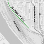
(Graphic: PBOT)
At long last the construction of a new bikeway on North Greeley Avenue is imminent. At least we hope it is.
At their meeting this week Portland City Council is poised to authorize a contract for the construction of the Greeley Multi-Use Path project. This change to a notoriously dangerous yet extremely vital link between the central city and north Portland was first slated to be completed in spring 2017. Then it was pushed back a year due to what the city’s transportation bureau said was a glitch in state contracting laws, only to be delayed once again last summer when PBOT says they ran out of time to get a quality bid.
Now PBOT says the $1.9 million project will go to construction this summer and will take about 4-6 months to build.
Advertisement
Here’s an overhead view of the latest plans showing the lane configuration. The new two-way path is on the bottom:
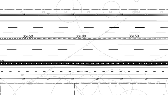
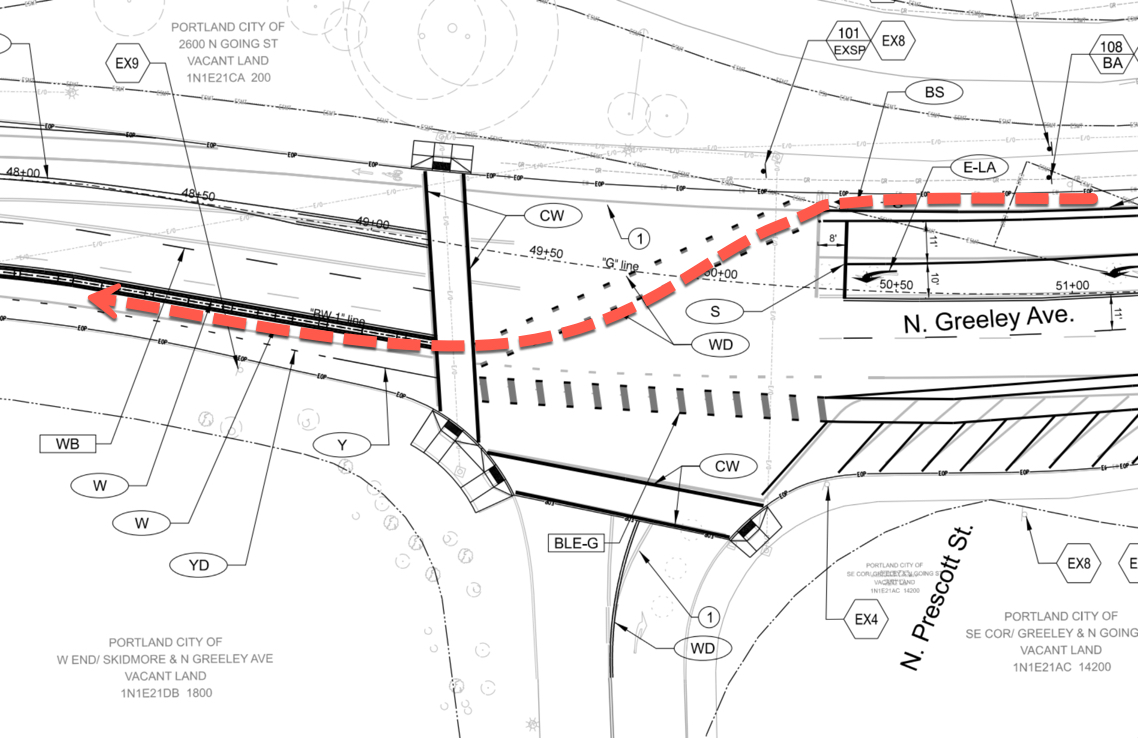
As we’ve reported, the design will be a two-way physically protected path on the east side of Greeley that will connect with the existing path that connects to North Interstate Avenue on the south end. Northbound Greeley users won’t notice much change in their route (except for others coming toward them in the opposite direction); but southbound users will notice a big change. South of Going Street, the plans call for a new bike signal, signage, and pavement markings that will direct bicycle riders from the west side of Greeley, across the intersection to the east side where the new path will begin.
I’ve added a red arrow to the latest plans (which are at 95% design) to show the southbound cycling movement:
The path itself will vary between 11.5 to 12-feet wide. It will have a two-foot wide buffer filled with a concrete wall, a.k.a. jersey barrier.
It will be interesting to see how this new path works. For comparison, it will be a similar width as Better Naito, another protected, two-way facility. But unlike Naito, Greeley is a very loud and stressful street where auto and large truck drivers will be flying by at 45-50 mph. Downhill cycling speeds are also an “x” factor in how the new, two-way design will work. Even will these concerns however, it’s likely to be a significant improvement over the freeway on-ramp roulette we’ve been dealing with all these years.
Funds for its construction come from a $650,000 allocation from the city’s Heavy Vehicle Use Tax (the project was endorsed by the city’s Freight Advisory Committee), $600,000 in maintenance funds set-aside by City Council, and $600,000 from ODOT’s House Bill 2017.
In related news, a pending lawsuit accusing PBOT of negligence for cycling conditions on Greeley is moving forward. Lawyers for the plaintiff, Robert Smith, say they’re in the discovery and deposition phase of the case and they’ve received answers from their inquiries from the PBOT, the Oregon Department of Transportation, and Brandon Swiger (the man who hit Smith with his car in December 2017).
View full 95% design plans here.
— Jonathan Maus: (503) 706-8804, @jonathan_maus on Twitter and jonathan@bikeportland.org
Never miss a story. Sign-up for the daily BP Headlines email.
BikePortland needs your support.


Thanks for reading.
BikePortland has served this community with independent community journalism since 2005. We rely on subscriptions from readers like you to survive. Your financial support is vital in keeping this valuable resource alive and well.
Please subscribe today to strengthen and expand our work.
Still a scary road to bike on – people treat it like a drag strip. I’d love to see 2-3 cameras on each stretch of it to keep the speeds down – since there is never really any enforcement on that road.
State law prohibits installation of speeding cameras on Greeley.
(Another example of how Oregon’s motoring-centric laws discriminate against vulnerable traffic.)
what law?
A few corrections:
1. a little less than 2/3’s of the path will by 11.5′ wide and that INCLUDES the shy distance from the jersey barrier. The rest will be slightly less than 10′ wide.
2. The existing speeds are OVER 55 mph, and the they are widening the lanes. That will not be great for the intersection where bikes are crossing diagonally, or for the narrow lanes on Interstate to the south or for the neighborhoods Greeley passes through north of here.
Please note that this is a freight project, being period for with freight-dedicated dollars. The design considerations begin and end with getting bikes out of the way for freight. This a terrible design for people driving in cars, walking or riding bikes. This “protection” is straight-up bike-wash
While I don’t necessarily disagree. Almost any project that results in physical separation from cars, particularly with jersey barriers, has my support.
Thank you for the update on this, Jonathan. Although it’ll make the trip down Greeley a minute or two longer in the morning, it’s much safer and will open this as an option for more users. At least once a month, when traveling north, I encounter a car in the bike lane (treating it as a breakdown lane) or to the inside of the lane, particularly as you make the sketchy transition onto Greeley from just past Hazelnut Grove. I’m glad that the jersey barrier will eliminate those interactions, but it’ll be interesting to see how it impacts auto traffic.
People riding bikes down Interstate Avenue southbound travel pretty fast. The intersection with the MUP (currently nearly exclusively used by people heading north) will become much busier with the proposed changes. There is not good visibility here, and with the 90-degree intersection (down a narrow ramp) with a 5-foot bike lane, this is likely to become a location for conflicts between people riding bikes. Is there anything PBOT can do to redesign this intersection to make it safer? There is quite a bit of space under the Greeley overpass that could be used for an expanded mixing zone. People on bikes heading southbound could head down the sidewalk and enter the bike lane obliquely if PBOT would cut a slot in the curb similar to the slot at SE Ladd/Clay
Hopefully the plan to move the homeless camp will actually go forward, thus reducing some of the current conflicts that exist on the MUP. The path is not nearly exclusively used by northbound cyclists. The people living in the camp and other people camping along Greely or moving to camps up on Willamette Bluff use the path more than cyclists do.
Will homeless people be able to camp within the protected bike lane space? It will be up to 12 feet wide, plenty of space for tents, and flat too.
The speed limits on Greeley are too high. This street is very dangerous to ride a bike on, walk along side, or drive a car on. The multiple lanes encourage dangerous passing. The City should not be promoting these high speeds on a City street so close to the Central City and at the edge of a neighborhood. The segment of the street that is 4 lanes and high speed is not very long, and the delay would be quite minimal if the speed limit was reduced to 30 or 35 mph, but the increase in safety and livability would be significant. Also, the lanes should not be widened; they should be narrowed to encourage slower traffic. Widening lanes to encourage speeding is contrary to the City’s Vision Zero Goals. Even if this MUP facility can improve safety for people on bike and on foot, narrower lanes and lower speeds would improve safety for people driving. This is not a limited access highway, it is a City street and it should be designed like one. Encouraging high rates of speeds guarantees that any crash is more likely to be fatal.
The proposed path plans to connect with the narrow concrete MUP between Interstate and Greeley. This path has poor sight lines, and is currently being used as a driveway by the City of Portland, the residents of Hazelnut Grove, and random citizens making donations to the camp. The residents have multiple personal vehicles parked along the trail. The City uses the path for regular trash pickup and to service portable toilets. Random citizens use this at all hours of the day to make drop-offs to the camp. If all vulnerable road users are going to be routed down this path, the City should install a series of removable bollards near Interstate. This would prevent residents from driving and parking here, and prevent random citizens from driving here while allowing emergency access and scheduled service calls.
I’ve heard the city is booting Hazelnut grove residents out to an industrial zone near Terminal 5, near Pier Park to the west of Lombard. So, this will be interesting to see what happens to this area and if other campers move into it after they move the services and residents out. I would expect that new temporary campers here might not be as neat and clean as the current residents of hazelnut grove.
Someone from the Overlook Neighborhood Association was at council today urging them to integrate an off road cycling track onto the site occupied by Hazelnut Grove and on the west side of Madrona Park. Some use like that would prevent other homeless people from moving in. Council didn’t seem interested.
that is a cool idea. If the City could get easements, an offroad trail network from Interste/Greeley to UP would be an incredible amenity for North Portland!
11.5′ and 9.9 feet wide is far too narrow for a 2-way MUP with such a significant hill. This route will certainly attract walkers, dog walkers, and joggers. It is already popular with bike commuters. There is a very wide range of bike speeds climbing hills, and there will be a very large speed differential between bikes heading uphill and bikes heading downhill. With speed differential comes the need to pass; this path will need to be much wider than the bare minimum of ten feet, and probably should be at least 14 feet. !2 feet may be adequate for bikes if there were a dedicated space for pedestrians.
Yes, this is a big concern. How to pass cyclists due to hill concerns and very different routine bike speeds, and also on the MUP sidewalk through the hazelnut grove, which has pinchpoints and a lamp post right in the middle of it. They will need to improve this sidewalk – make it wider, remove the posts in the middle, and clear the blackberries that grow across it.
I agree that the existing sidewalk should be widened and fixed for this project, but this project will not do anything to the existing concrete walkway
If they make no improvements to the sidewalk (on/off transitions; width, pinchpoints, obstructions, vegetation), and they route the main flow of 2-way bike traffic along it, this project will indeed make a bad situation worse.
Also of concern will be the blinding on-coming headlights that southbound riders will face on both sides, from head-on car and truck traffic just 3-5 feet to the right of the rider, and from head-on bike traffic just a few feet to the left of the rider. This, on a downhill at >25 mph typical bike speed. Good luck holding your line and avoiding road debris in the face of these blinding lights on both sides and northbound bikes coming over to pass cyclists and joggers. I think the problems of design of face-on car and bike traffic for south bound cyclists attempting to ride this in the non-daylight hours is more serious and dangerous than the current alignment. Perhaps they can add some additional several feet of visual barriers on top of the jersey barriers to reduce on-coming car headlights. I do not think head-on bike traffic (2-way cycle track or whatever you want to call it) on this hill, with the proposed widths listed, will be much of a safety improvement, and will have new, serious safety and maintenance issues.
Don’t forget getting blasted in the face with road spray from big trucks on wet days too. Always a pleasant experience as anyone who rides up the Going street hill from Swan Island knows.
New AASHTO standards for bike paths are coming out this year. They set the minimum width for two-way paths at 14′, so this design is obsolete before it’s even built.
Bike washing, indeed. PBoT needs to raise its game if it expects to raise its bike modal share.
The MUP will terminate at Going, and there are sidewalks along the west side of Greeley. However, steps up to Madrona Park, Adidas, and Overlook neighborhood are on the east side and there is not a safe crossing until Sumner! This project should consider continuing pedestrian facilities along the east of Greeley, at least to the stairs to Madrona Park. Alternatively, add a crosswalk with a center median island and RFB across from the park. Related to this, there is not a safe connection between the Going Greenway and Greeley bike infrastructure; this project should do something to create a safe connection.
The NP Greenway had proposed at one point to create an MUP on the west side of Greeley that would go around highway on-ramp. There are challenges with the grades, and with UPPR ownership, but it is a better route from certain perspectives, or maybe a good complimentary route. When Charlie Hales was Mayor, he claimed to be in negotiations for this route.
People driving and freight haulers have 2 very fast, very large direct routes that lead directly to highway on-ramps: Greeley and Going. People using bikes have been only marginally accommodated with narrow lanes along this high speed road with dangerous ramp crossings. People walking have had not been provided with any space along Greeley. I am glad to see PBOT recognize this is completely inappropriate and propose some space for people to walk and ride bikes. However, they are doing the community a disservice by promoting higher speeds, and not creating a safe environment to be shared by people walking and biking.These changes are likely to the last improvements this street sees in decades, and they are woefully inadequate at improving safety for drivers, bike riders or pedestrians. With a few changes, Greeley could become a much more appropriate street to have within the neighborhood, and it could a much better job at providing traveling options for all modes. PBOT should be pressed to do a much better job here.
Is this the Heavy Vehicle Use Tax that city council just eliminated due to pressure from freight?
I’d love to see a Ford F-150 with WA tags tax.
I’d love to see a light truck/SUV tax. Let’s do it by the pound and make it proportional to the bike tax. Let’s see, these things weigh about 300 times as much as a bike, but let’s let them spread the payment out over a decade, so 30 X $15 = $450/yr. That still wouldn’t cover the cost of the damage they do, but it would give them a little “skin in the game”.
It wasn’t eliminated. It was reduced and readjusted a bit.
Jonathan, I would love to hear from whoever designed this facility, is there any chance of getting an interview? I very often look at bicycle facilities and think “whoever designed this has never ridden a bike here.” Maybe I’m just being a Debbie Downer though – I would love to learn about the constraints and process that results in infrastructure like this.
If each 12ft lane was changed to 11.5, you’d get an extra 1-2ft of bike space (one of the car lanes is 12-13ft wide). It would make a big difference in passing ability. Considering the trucks go 45mph on 11ft roads in Portland, I imagine they can also make do with 11.5 ft lanes here
Huh, a lot of folks down on this project. This is a massive, massive improvement on the current situation and should largely eliminate the primary safety threats in my view (crossing over the I-5 onramp and avoiding traffic from Swan Island). I’ll definitely be using it in the future, as right now I ride Willamette to Concorde to Interstate instead.
Reducing speeds on Greeley would be nice, but this is a major freight route that connects to I-5 and I don’t see that happening anytime soon. With physical separation, this is a very good change.
Jake,
creating separation is a good thing, but this project is failing to provide a safe connection for the southern 1/3 of the route for bikes/peds. Jonathon points out the proposed section for a portion of the bike route, but 1/3 of the route will be an unimproved concrete walkway less than 10′ wide that connects toIntersate vvia a singel ramp. PBOT is doing nothing (and has no plans to) study, design or improve this. It is also taking a dangerous road with existing speeds exceeding 55 mph and making it less safe for people driving on or crossing Greeley. This project is pretending to address an extremely unsafe condition of the bike lane crossing the ramp, but it is not actually designing a safe route for pedestrians and bike riders. Don’t get me wrong, Greeley is VERY unsafe for all modes (except huge trucks) but this project will not adequately address those safety concerns. From a Vision Zero perspective and from the perspective of providing useful, safe infrastructure for people in North Portland, this project is a failure. This project is literally a freight giveaway.
I agree the connection from Interstate to this path is not ideal, but the width is not a tremendous issue in my eyes. This is likely never going to be a route that massive numbers of people ride. Ten feet is a decent amount of room to pass a slower bike, barring oncoming traffic. Given my guess of typical bike commute patterns on Greeley, I feel that oncoming traffic is not going to cause a lot of issues. Time will tell.
Jake,
If the 9.9′ concrete walkway width doesn’t alarm you, then take a look at where that connects to Interstate. A southbound bike will need to make a 90-degree left on to a sidewalk with a sign post narrowing it to approximately 7′ after 10′-15′, the rider then a 90-degree left turn down a single ramp then an immediate 90-degree right turn into a 5′ bike lane at the bottom of a steep hill (fast drivers, fast on-coming bikes). Keep in mind, this is also the route for people walking, jogging, pushing shopping carts AND for people on bikes heading northbound who will be sharing the ramp, the sidewalk and the 9.9′ concrete walkway. I spoke at length with PBOT, they ascknowledge this is not good but they promise to do nothing about it for this project. THEY WILL NOT TOUCH THIS. Maybe in the future. Maybe.
This project will reduce the width of the roadway, which should encourage slower driving. I would strongly support multiple speed cameras, though.
Chris I,
I don’t think this is correct. They are widening the outer lanes, and shifting the lanes west and getting rid of the shoulders and southbound bike lane. They are also adding some paving. in places according the plans linked in the story. Narrower lanes would encourage slower driving, this project is adding wider lanes.
I will continue to not ride Greeley – I just don’t find it enjoyable. While this will make it safer and hopefully get rid of the detritus from the trucks (mainly staples that give you flats), I still won’t like taking that angled crossing on greeley and wish the could have found a better way. Honestly wish they would have made ramp coming gong a NTOR signal and started the path earlier so it could have shared a stoplight at Killingsworth or with Adidas or something (or used Adidas bridge).
I really enjoy being able to jam down Greeley to Interstate very quickly and personally never felt at risk even with that heavy freight whizzing by, that’s just my opinion, I’ll miss that… Anyway, hoping everyone plays by the rules and takes it safe after the modifications, especially crossing Greeley to get to the path going south. Also, wondering if families will get that warm and fuzzy feeling using this path since it’s currently dissects a homeless camp with frequent garbage and debris at Hazelnut Junction…
I don’t ever go down Greeley due to it just not being a fun route..I go up.down Interstate Ave or Mississippi then is side street fun.
do people biking coming from the south to Swan island just use River St to N port Center Way?
I am not seeing much benefit for cycles, there seems to alt routes that are better…just need some signage..
Why not just go behind the On Ramp to I-5 south…?
And make a overpass for bikes and walkers over the Going to Greeley right hand on-ramp…
I think that land behind the on-ramp is owned by the RR’s and they aren’t known for giving up land like that.
Glenn, I suspect this solution would cost a significant amount more money. Building a ped/bike overpass in particular sounds like a multi-million dollar proposition to me.
City should take the opportunity to improve the Concord street Ped Bridge crossing of N Going st during this construction process. Will the construction period for this “improvement” completely eliminate N. Greeley in both directions for all of summer of 2019 (4-6 months)? If so, City should look to bolster alternatives and shore up improvements in the bike network in this area along Interstate, Concord, Ainsworth, Willamette, and I guess Vancouver. I will be really bummed if I have to ride on Interstate or Vancouver b/c Greeley is closed.
I don’t really get why laying out a line of 1-1/2 miles of Jersey barriers and scraping/applying paint stripes for lanes and putting up traffic signal mods at one intersection will take 4-6 months…. anyone know why this can’t be done in 4-6 weeks? Maybe this project won’t happen after all?
I really enjoy the concord curly-q’s.
i’ve been living in north portland for about 6 months, and this is my commute. i hate it so much! but, greeley is the quickest route anywhere. i prefer not to ride greeley in the dark (so lately, i’ve been going out of my way, north up williams on my way home). yes, this is an improvement. but, anything is better than the current setup.
the diagonal crossing (across 4 lanes of traffic) will not be pleasant even with a light. heading south, you can pick up a lot of speed, and i think it’ll make for dangerous interactions with other cyclists heading north. then, where do we go at the southern end? back to that terrible intersection on interstate, through hazelnut grove. i’ve never had any troubles with folks who live at hazelnut grove…it’s the rats. finally, this project won’t even be done until the end of the busy cycling season (at the earliest).
i know this project has been delayed for far too long, but i’d like to see the city do better. what’s better? i don’t know, as i’m not an engineer. seems like there could be opportunities for better cycling and ped infrastructure.
I’ve been riding this for a very long time, and I have to tell you- a diagonal crossing with a signal(I assume) is actually an improvement over leapfrogging i-5 onramp traffic going 5 times your speed (10mph vs 50). Note, I say it’s an improvement, I’ll reserve judgement over whether or not I’ll call it “good” when I find out how it will actually be implemented.
Kate, I agree with you! There is A LOT of north Portland that gets funneled on to Greeley when heading south. It can be avoided by traveling out of direction, but PBOT should recognize what an important connection this could be for most of North Portland and they should take the time to actually design meaningful improvements that provide safe connections.
“if you build it, they will come?” i want to believe but still not sure. i’m concerned greeley will always have be branded as unsafe even with improvements :/
With these “improvements”, it will definitely remain unsafe.
This is not an MUP along N. Greeley, but a two way cycle track. npGreenway (Friends of N. Portland Greenway Trail) continues to advocate allowing public use of the existing paved private road (aka Ash Grove Cement Road) between Swan Island @Port Center Way and N. Tillamook & Interstate. Mayor Hales office did play a big role in getting UPRR to consider propose option along the west side of Greeley…behind the trees using some RR property. Unfortunately this would require a MU bridge parallel to Going Street over the RR tracks, and came in at about $25M for one mile of trail! So we are back to looking at how the existing (very quiet and relatively safe) paved road along the River can be open to public use.
I would love to see the route go along the Ash Grove Cement Road, but I think a viable alternative is along the west side of Greeley. Instead of a bridge, why not just keep the path right on the edge of RR property and run at grade all the way along the edge of the bluff? There would be no crossings, and you would have a beautiful natural area on one side of you the whole route. The path would have to climb over the RR tunnel at one point, then again to meet the bluff side of the waud bluff bridge.
Yes- this is the real answer. I wish we could get this opened up.
Heading north I like to take Interstate up the hill, cross the tracks by KP, go through Overlook to the Concord bikeway and the pedestrian bridge across Going, then head back to Greeley by Adidas. It probably takes a little longer than Greeley all the way but I find it much more relaxing and enjoyable.
Same, best route in my opinion. It follows the Greenway and is usually low stress.
Awesome choice, if you love climbing hills! (ps, I dont)
So, I’m looking at the first image- N Prescott doesn’t exist anywhere near Greeley. And given that none of the diagrams have a compass arrow, I’m forced to conclude that the northbound bike lane on Greely at Going will cease to exist? Can you share any insight you might have?
Ok FYI that sort of hidden link at the bottom of the article contains the PDF from which the images were taken, but if you’re me, you won’t see it full size until you download it and open it in something that isn’t your browser. Here’s the full image, including a compass line:
https://imgur.com/a/J1nyD2h
If you dont like it, you can always take the shortcut through the RR yard. I used to commute several times per week along Greeley to get to/from Swan Island from SE. I would regularly choose trespassing on railroad land over putting my life in danger on Greeley. This plan is a step in the right direction. People will bitch (oh, they always do!), but it will be better than it is today, or ever has been.
PS: I only got stopped once in the railroad yard and the RR police were nice and just gave me a warning.
Great comments everyone. I can only add some great photos of 2016 to 2019
Greeley sucks now, it will suck less for bikes after this “upgreyedd”
Drivers of motor vehicles will continue to kill and injure each other. The guard rail has been totally rebuilt several times the last 3 years.
Photo gallery:
Crashes 2016
https://drive.google.com/file/d/0B-_lkfRp66-0WjZxX3g0d3ZDQjQ/view?usp=sharing
Saia truck going 63 next to bike lane ( limit is 45)
https://drive.google.com/file/d/1GFYgyfJUuDXgEj5OzWlbfKOkl0t8bZEP/view?usp=sharing
2018 crash (Dec)
https://drive.google.com/file/d/0B-_lkfRp66-0RjRRaEdaNDZERFdDc2V3Y3NaeFpsVjlKc2Zz/view?usp=sharing
Crash 2018 ( July) smashed new guard rail
Note the sign with green and yellow in the picture below.
https://drive.google.com/file/d/0B-_lkfRp66-0bmZIb21zTEtKVmdXTE0yTWVzR2xYOWhPcmhZ/view?usp=sharing
January 2019 car demolition derby update – That green and yellow sign (above) was split in half by another crash in October 2018. The yellow part of the sign ” was hauled away by PBOT. “right lane exit only” does not exist any longer. Only the green half remains, and the only 1 of 2 posts is in the ground. Behind the Jersey Barrier is a car racing wheel, rim, tire, axle and half shaft. Worth a lot in scrap money if you are hard up.
We are living in Idiocracy, The city and state will not install speed cameras and will not lower the speed limits. I say let the car drivers keep kicking each other in the balls.
new problems for bikes:
– bikes will head on crash each other
– Spray and dirt will be a bit nastier head on, headed South
– Asking the city to clean up all the car parts that fly over the cement wall
– demanding the city repair all the damage to the cement wall
– having to zen out and go slower down the hill ( a good thing)