
(Photo: Jonathan Maus)

Initially slated for spring 2017, a project that will create a protected bike path on Greeley Avenue in north Portland has been delayed again and isn’t expect to be built until spring 2019.
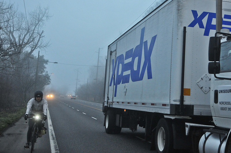
The Portland Bureau of Transportation plans to piggyback on a repaving project on Greeley between Interstate and Going in order to create the new bikeway. The current street cross-section of four standard vehicle lanes and two unprotected bike lanes is very dangerous and stressful. People drive very fast at this location and bicycle riders in the southbound direction are forced to negotiate a freeway onramp with auto users traveling over 50 miles per hour.
We first reported on this project 16 months ago when PBOT said it would be done in spring or summer of 2017. Then in July 2017 PBOT said a contracting glitch forced them to push the project back another year.

The latest news we’ve heard is that the project has been delayed again. Here’s the lowdown from PBOT:
The multi-use path (MUP) project originally came to light in 2017 because this stretch of N Greeley showed up on PBOT’s repaving list. In 2017, the project was delayed due to contracting rules limiting the dollar amount of work that could be done by PBOT maintenance forces.
As the project team continued to work on design of the multi-use path, it became evident that the entire width of N Greely would need to be repaved at the same time that the barrier was installed. When the barrier is installed, the road will need to restriped. The pavement is in such bad shape that the stripe removal needed in order to restripe would leave potentially dangerous “ghost stripes.”
Advertisement
When the project shifted from barrier installation and paving of the MUP to full-width paving, the team realized that we would not have time to complete the design, contract out the project, and acquire the barrier in time to catch the dry weather window needed for paving in 2018. Fabrication of the barrier will require a six to eight week lead time; the contracting process takes three to four months from advertising to notice to proceed. Another factor in the decision to push out the project was the timing of the bid. If we hurried to construct in 2018, we would’ve gone to bid in August. Our experience has been that bids that late in the “paving season” tend to be very high, plus all of the paving contractors are already booked for the season by that time.
We will have the contractor on board and ready to go in spring of 2019.


PBOT’s plans call for a two-way, 12-foot wide multi-use path on the west east side of the street separated from other road users by a continuous concrete (“jersey”) barrier. The path will be adjacent to four other travel lanes (the same amount there is today). Since the new path will be bi-directional, it means southbound bicycle riders will need to use a new signal to cross Greeley at Going to continue southbound (the existing bike lane will be removed). This movement will mean much slower travel times for bicycle users in exchange for the expected safety benefits (the southbound bike lanes currently allow bicycle users a very fast and direct route to Interstate).
For more on this project, check the official project page and our related posts below.
— Jonathan Maus: (503) 706-8804, @jonathan_maus on Twitter and jonathan@bikeportland.org
Never miss a story. Sign-up for the daily BP Headlines email.
BikePortland needs your support.


Thanks for reading.
BikePortland has served this community with independent community journalism since 2005. We rely on subscriptions from readers like you to survive. Your financial support is vital in keeping this valuable resource alive and well.
Please subscribe today to strengthen and expand our work.
“PBOT’s plans call for a two-way, 12-foot wide multi-use path on the west side of the street separated from other road users by a continuous concrete (“jersey”) barrier.”
all the pictures and other description suggest the path will be on the east side of the street. then again, I confuse easily.
Ugh. My mistake turnips. You are correct. It will indeed be on the east side of the street. I’ve edited the post. Sorry.
If it’s a full paving project, why are they continuing with the same shortcut design that should have been implemented by now? PBOT needs to quit doing this. Quick and temporary safety enhancements are getting postponed to turn into badly-designed permanent concrete junk. Meanwhile, people in cars are offered lane after lane of pavement which they use to race to the next stop light or bottleneck. Now with fresh pavement, they’re going to put back the same last-century 4-lane layout? They should at least remove one of the downhill car lanes, probably also the spare uphill one. (Induced demand is real and applies to all lanes of all types, existing or new.) Why can’t PBOT do anything quickly or correctly?
“do anything correctly”. Hmmmmm, according to whom ? Bikers?
Please consider the amount of. businesss and industry that is on Swan island and the importance of access to freeways for their transport of materials. Also consider the number of people employed by companies located on Swan Island and at Adidas at the top of the hill. If your suggestion is that PBOT should disregard their obligation to provide efficient pathways for the movement of freight and also make it even more difficult for adidas employees to get to and from work than it already is just so they can do what Is best for bikers…I’m not sure that they can.
If anyone here has a suggestion for how to pitch such an idea to the companies that rely on Greely for their livelihoods, I’d be interested to hear it.
I see lots of opposition to this plan but no viable suggestions for how else to eliminate the bike crossing at the I-5 on ramp. The. bike path to the right of it would be on Union Pacific land so likely not possible. Who’s got something else?
Ted G, this is a lot of hyperbole. There is plenty of space to improve the exisitng concrete walk at the southern end of this path to something that functions well for bikes. It could widened to 12′. Removable bollards could be added to control vehicle access. bikes continuing south on Interstate could continue down the sidewalk IF PBOT would remove a short section of curb and allow the bikes to merge diagonally into the bike lane instead of using 2 90-degree turns.
Alternatively, instead of adding a diagonal bike signal at Going, they could add signal to control freeway access, and change the on-ramp to a 90-degree turn. This would deal withthe bike conflict, and if could done without adding any more delay than the current proposal of a diagonal, bike-only phase. Instead of solid, jersey-cbarrier proteced MUP, the jersey barriers could be staggered and provide a protected 6-foot bike lane on either side of the street. Moving the signal here could also help slow traffic, which is one of the biggest failures of this plan. Accommodating freight does not mean we need 12′ driving lanes. Freight could move through here at 30-35 mph on 10.5′ lanes without any problems. These wide lanes support speeding in an area where high speeds are already a problem. When traffic is light, people drive over 55 mph here and carry those speeds on to Interstate (with 5-foot bike lanes) or into the neighborhoods when Greeley transitions to a street lined with houses.
NO ONE is advocating choking this street to the point that people and goods can’t access Swan ISland. I am advocating for a thorough and reasonable design of the bike route they are creating, and for this project to address the real and acknowledged problem of people driving too fast in this location.
On their project website PBOT describes Greely as a high-speed corridor with heavy freight vehicle traffic. I did not read anywhere that PBOT is interested in changing that. It sounds like you think slowing traffic down should be the purpose…but it’s not. The design is intended to allow traffic to move freely along Greely while making things safer for cyclists, which I think it does. I think your suggestions for the connector path to Interstate are good ones, but without knowing the constraints along that area, we cannot know if they are possible. So while I understand your desire to slow everyone down and make the experience of riding down Greely better for cyclists, that is not the purpose of the project and the design reflects that.
The speed limit is 40 mph. Observed speeds (median) are 53 in one direction and 56 the other. PBOT wants this to be free-flowing, but they have also adopted Vision Zero. The speeds on Greeley are not for people driving. This project is the sole opportunity PBOT will have to introduce design changes that can encourage drivers to obey the speed limit. Design tools like speed bumps or chicanes will not work here because it is a freight route. Increased signalization and narrower driving lanes are 2 design changes that have been shown to decrease driving speeds, could work on Greeley and are not being considered.
From my perspective, PBOT has ONLY designed this project through the lens of moving freight. The have ignored the implications to the traffic systems outisdie of this stretch that will be adversely impacted by hte higher speeds induced by these wider lanes. They have also not addressed the safety implications caused by creating a bike route on an existing concrete walkway. PBOT could address these issues if they acknowledged the problem, but unless they hear from people, they will treat this project as providing a single solution to a single problem: freight wants to move more quickly and freely. Ask them to do more and they will be able to do more- this project can accomplish multiple goals with some creativity and careful design.
Once this project is built, PBOT will not touch Greeley for another 15-20 years.
I still do not like the obnoxious 2 way MUP approach of a single path on the east side. I would rather have the west side bike path be opened to the right side of the on freeway ramp then rejoin, and murge with the Interstate southbound downhill bikepath. This from someone tht has been riding this route from way before the freeway on ramp.
Agreed! Of course, that would be a “best” solution, and PBOT is only interested in “fig leaf to let us make a barely plausible claim that we’re upholding our commitment to Vision Zero.”
Have you seen the brand new MUP on N. Lombard @ N. Columbia? Similar treatment as this N. Greeley plan – they removed part of the bike lane and ask the bikers to cross the street twice to access the mup. Cross the street in front of speeding trucks that are cruising through a right-turn yield sign at Columbia – good luck – and then cross it again at some weird mash up of intersections at the entrance to Schnitzer steel scrap yards – again, wait and pray for a way to get across traffic. This just to ride a short but dangerous section where they could have easily put in a bike lane on both sides of the street. In the middle of this section, the new MUP now crosses (as a sidewalk) the entrance driveway of one of the busiest trucking container yards in the city at NW Container Services where trucks are roaring in and out of in all directions. Again, a less safe option for cyclists that was built at no small cost, lots of new concrete and curb works, while removing some existing bike lanes on street. Another bronze design.
Another example of a project FOR freight interests at the expense of safety for people on bikes. PBOT is literally shunting bikes off the road and on to half-baked, undesigned, unsafe facilities. The only reason I can come up with for the bike activist communist to not coming unglued about this is that they are providing a few stretches of physically separated bike lane (missing the forest for the trees?)
Agreed. I am not sure who owns that land though – if it is the RR, I doubt any sort of path will ever go there. By far the best design and what should be done. I will continue to not ride this route even though it would be the fastest for my commute.
I certainly hope that planning and construction for the Rose Quarter I5 widening ( if it is built at all) will proceed at the same glacial pace. Hopefully its speed will be inversely proportional to its cost compared to the Greeley project.
The city adopted Vision Zero on June 17th, 2015. In the fourth year of this policy, Greeley remains dangerous by design.
In composition, PBOT’s response is something my freshman instructor would have balled up and thrown in my face. In substance, it feels the other way around.
Just in time for the need for a new “study” to arise and delay it again.
The Greeley ROW is 70′ and the cross-section shows 60′ of travel lanes and 5′ of green on both sides. On the MUP side, why not move the 5′ of green into the space between motor and human traffic so we have a 7′ separation? Every inch of distance reduces exposure to diesel particulates.
it appears to me that Parks is looking to accomplish the ‘signature trail’ of the 2030 Bike Master Plan for Portland on the cheap, on the easy, but lacking in the ‘signature’ department. My understanding is npGreenway,( the advocacy group long working on the North Portland Willamette Greenway Trail ) does not support this as a part of the trail and hopes to continue working to achieve a better alignment.
I was disappointed when Parks became the lead on the NPWGT, rather than PBOT. An unsafe trail is a not used trail. Few will use this, I am certain.
Please note that the 11.5′-12′ MUP INCLUDES the shy distance from the jersey barrier (effectively removing a foot or so) and ONLY applies to the north 2/3’s of the route. The southern 1/3 of the proposed route will use an existing concrete walkway that will not be improved in any way. This walkway is less than 10 feet wide. It is used by personal vehicles to access Hazelnut Grove and regular service vehicles for the trash and portable toilets. The route deadends into the sidewalk on the west side of Interstate where bikes will have to take a 90-degree turn, travel down the sidewalk narrowed by poles then take another 90-degree turn down a single ramp (to be shared by 2-way bike traffic) followed immediately by another 90-degree turn into a 5-foot bike lane at the bottom of the Interstate Ave hill. Meanwhile the traffic lanes will be 10.5′, 11.5′, 12′ and 10.5′ to maintain the current speeds of OVER 55 MPH!! This is a project to remove bikes from the road to make room for freight. Don’t believe me? Ask PBOT. While you are at it, ask them to address the unsafe speeds on Greeley, and address the unsafe conditions they are creating for bikes with this project (despite the fact that this project fundamently changes how the existing sidewalk is used, PBOT claims it is magically “not a part of this project”
Don’t even need this project. Once they start tolling 1-5 @ Going St, traffic will move to Interstate Ave and Greely causing traffic jams like Portland has never seen. Cars will essentially become jersey barriers
Hrm. Another project where it feels like bicyclists are an inconvenience that must be accommodated but not in any really dedicated or helpful fashion. I appreciate there being a barrier planned, but we need to treat bicycling as a valid, priority mode of transportation…not something to be shoved to the side and given a little space.
There is also the question of how they are going to keep this lane clean. I biked it for nearly a year from St. John’s to Downtown and there was a regular problem of debris in the bike lane (as well as flooding on the West side of the street).
About the
Over the past 6 months I have had some near head-on collisions with motorists driving UP this sidewalk. It’s a blind corner on your way down onto Greeley too. Without any improvement, and with increased volume, these conditions are going to lead to accidents.
Yeah, without in any way criticizing the houseless members of our community, I have seen a lot of motor vehicles as well as garbage on that stretch of sidewalk, which in my eyes would make it a less than ideal transportation link. I suppose a jersey barrier will cut down on motor vehicles, at least.
please contact PBOT about this. I have been hounding them, but I am, so far, the lone voice advocating for this.
Of course it is delayed…..though once built I may use it. Many however will still take the lane and bomb the hill as they will not.like the closed in, trapped in the tunnel, effect or the lower speeds.
I really don’t understand how the two way bike path is going to work. Going downhill, cyclists will be moving fast. Closing speed of cyclists uphill vs downhill will be easily 20 mph even if both are riding sedately. When pedestrians are present it will be even worse. And there will have to be some bollards to block vehicles from using the path, or it will be a real cluster.
I’m not too familiar with the homeless activity there but if the camp gets disorderly or attracts a problematic crowd, cycling on the path will be even less pleasant. Bike paths that are heavily used by the homeless are less conducive to commuting, because sooner or later, you’re going to have an unpleasant encounter than is more significant than simply dodging trash piles. I ride to Vancouver via the slough and I-5, and have an incident about yearly. Last year a homeless guy on a bike towing a trailer tried to run me off the slough path. Today a guy tried to shoulder me into the I-5 bridge girders. I have more negative incidents with the homeless people on my commute than I have with drivers.
Jonathan, thank you for re-upping this post. I’m very glad to know I”m not alone as I read much of the feedback here.
I hope PBOT designers will take heed and revise before implementing this design. I know it is not easy. this is a challenging situation and we in the general public are not aware of all of the constraints involved. However, there appear to be MANY opportunities for improvement in both the functionality of the design and the safety protections.–even with the new jersey barriers.
We can do better.
Why not have a design charrette about this like we have for other key pieces of infrastructure in the past? Let’s get to World Class!
And when can we build the North Portland Willamette Greenway Trail?
I take Greeley southbound every weekday morning. It’s not great, especially crossing before the I-5 ramp, but this design looks like it might be worse.
Agree with Scott and the others who say we can (should) do better.