The SW Corridor Project has reached a major milestone with the release this week of its Draft Environmental Impact Statement — a required step for the estimated $2.8 billion, 12-mile TriMet MAX light rail project to receive federal funding.
The plan has been seven years in the making and once complete (possibly around 2027), the new line would go from downtown Portland’s transit mall to Tualatin via Tigard. As proposed, the route would go along Barbur Boulevard until the Barbur Transit Center (at SW Capitol Highway) and then cross over I-5 on a new bridge that would run southwest along the freeway to Tigard before crossing Highway 217 and heading south to Bridgeport.
When the Portland region has built previous light rail lines, new bike lanes followed. The Yellow Line up Interstate got us new (albeit crappy and narrow) bike lanes, and the Orange Line came with an unprecedented investment in bikeways. Throughout planning for the SW Corridor, active transportation advocates have watched closely and sat on advisory committees to make sure the project would result in not just a new high-capacity transit line; but high-capacity bikeways as well.
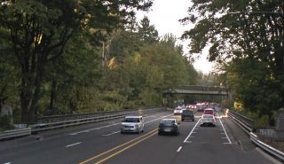
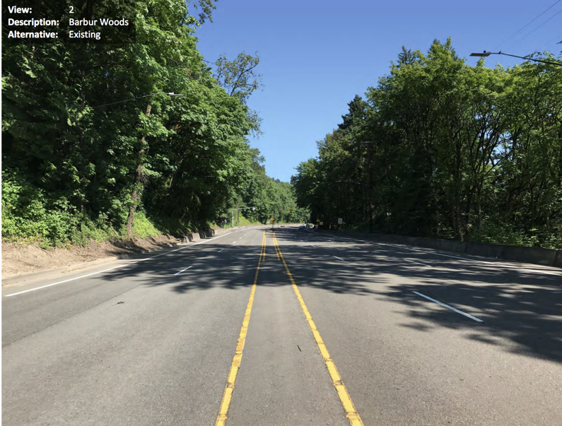
There’s been hope for years that this project would finally bring relief to the white-knuckle riding conditions on Barbur Blvd north of downtown Portland. The road in the “Barbur Woods” section has four standard lanes and no shoulder or bike lane over two closely-spaced trestle bridges. The bike lane gaps force riders into a shared lane where people often drive 50 mph or more.
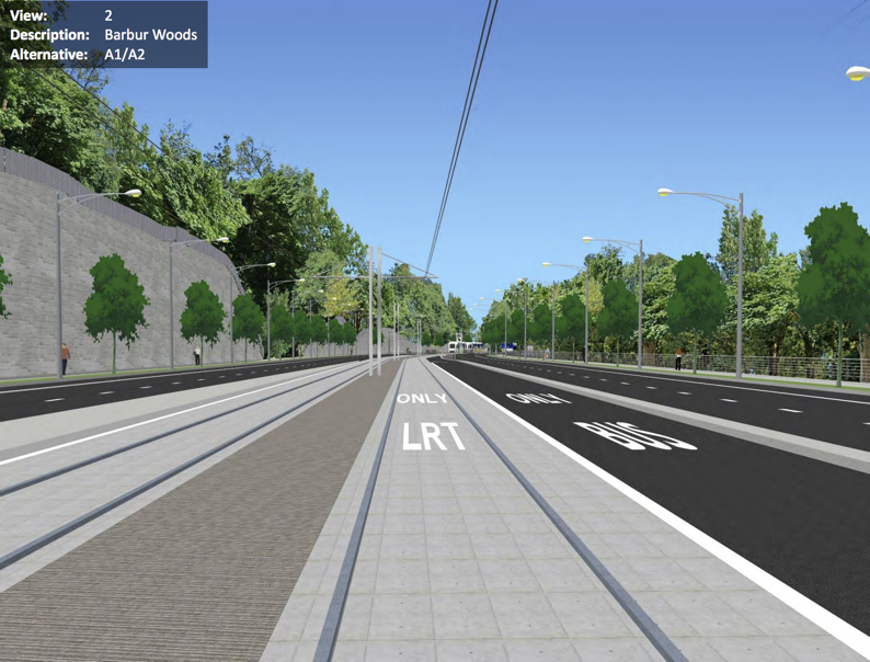
To deal with this issue it looks like Metro has chosen to simply avoid it. A “refinement” made to the proposal would move the alignment to the east side of Barbur Boulevard for about a mile in the woods section on a new, aerial structure. In the DEIS, Metro says the decision to leave Barbur at this location was done to save money, gain “constructability advantages” (the old bridges won’t support the weight of MAX trains) and to avoid replacing the trestle bridges, which are likely to trigger historic structure requirements.
This means the Vermont and Newbury bridges won’t get improved with this project. What about the new aerial bridge TriMet would build? NOTE: We’ve deleted a previous reference to a SW Portland Post article.
Here’s what Metro Planner Matt Bihn shared with us:
“To clarify, options for light rail in the Woods include replacing the viaducts, or skirting them to the east with a separate light rail facility. In either case, there will be bike and pedestrian improvements, but the location has not been decided. They could be on the replaced viaducts, on a light rail structure, or on a separate bike/pedestrian facility. Details will be worked out in final design.
The SW Portland Post article that BikePortland referenced focused solely the discussion of the option of skirting the viaducts and incorrectly inferred that bike/pedestrian facilities would not be included.”
Advertisement
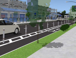
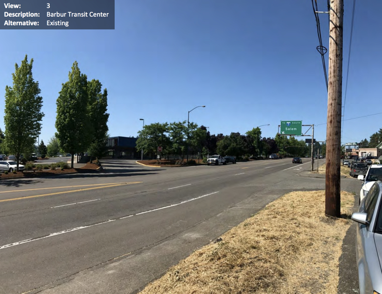
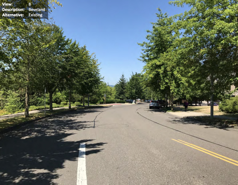
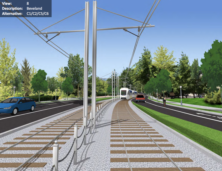
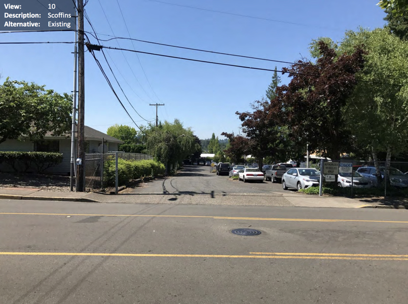
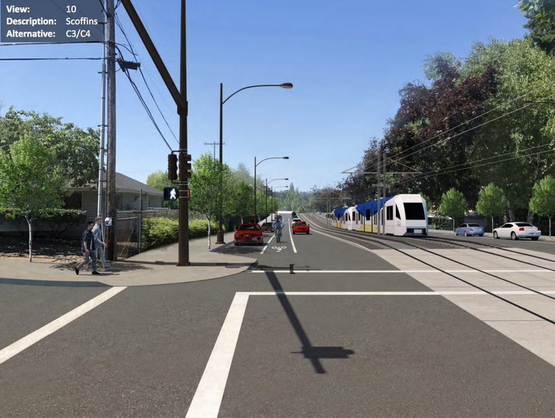
As for other sections of the project, the DEIS included some before/after visuals (below) that give us a hint of what’s in store in terms of bike facilities:
➤ Barbur Woods
➤ Barbur Transit Center

➤ Beveland
➤ Scoffins
➤ 53rd Avenue
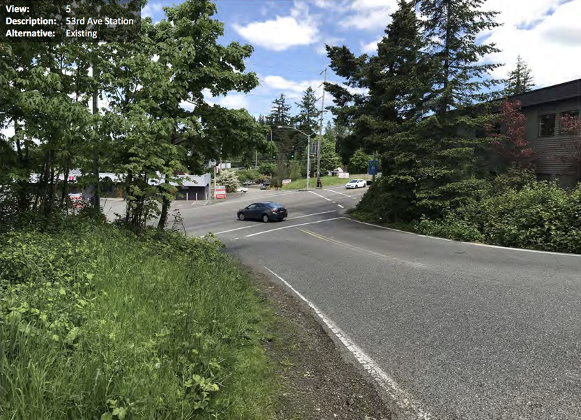
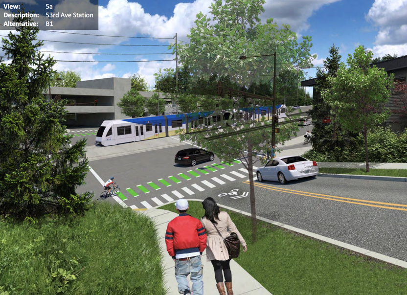
As you can see, these bikeways look rather underwhelming.
A 45-day comment period has been opened on the DEIS and Metro is hosting a series of open houses and info sessions so you can learn more about it and give informed feedback. The next open house is Tuesday June 26th at Markham Elementary School from 6:00 to 8:00 pm (more info here).
CORRECTION: Please note that this post originally cited a SW Portland Post article that misquoted a Metro planner. That quote, which we also ran, said there would not be a bike path along with a potential new light rail bridge around the Newbury and Vermont bridges. We regret the confusion. Please keep in mind that the DEIS represents a very early look at the project’s alignment and overall footprint — specific design details are yet to be decided.
— Jonathan Maus: (503) 706-8804, @jonathan_maus on Twitter and jonathan@bikeportland.org
Never miss a story. Sign-up for the daily BP Headlines email.
BikePortland needs your support.



Thanks for reading.
BikePortland has served this community with independent community journalism since 2005. We rely on subscriptions from readers like you to survive. Your financial support is vital in keeping this valuable resource alive and well.
Please subscribe today to strengthen and expand our work.
Ho-hum bicycle infrastructure. I like the bus-only lanes, though. I was on bus 54 today and it was packed.
The bike infrastructure (and frankly urban design in general) in those images is shockingly bad. Everyone involved in this should be ashamed by those images. Those would be marginal designs for a cheaply built retrofit. They’re unacceptable for what would be 100% new construction.
There’s a lot of explaining to do about what’s gone wrong with this project. Early plans for the SW Corridor included a tunnel under Marquam Hill that would serve OHSU and Hillsdale. That was abandoned in 2015, because it would add $732M-$900M to the $1.9-2.1 billion project costs (at that time, envisioning a route all the way to Tualatin):
https://www.oregonmetro.gov/sites/default/files/2016/06/30/SWCP-July2015-StaffRecommendations.pdf
One of the justifications for the surface alignment over the tunnel was that it would “include the replacement of Vermont and Newbury viaducts on Barbur Boulevard, or construction of parallel bike and pedestrian bridges”.
Now we’re being told that the route will only run to Bridgeport village, won’t include the replacement of the viaducts, and won’t include bicycle / pedestrian facilities on the new viaducts to the east of Barbur. This comes at a cost of $2.64-$2.86 billion, for a project that would a) still be slower than driving in year 2035, b) only marginally faster than the existing express buses in year 2035, and c) is only expected to increase transit ridership in the corridor by 8% over the no-build alternative.
I love transit and want to see rail to all parts of our region. I’m more than willing to vote to pay higher taxes for it. But at these kind of costs we need to ask why we’re not getting more out of it.
Hear, hear. I ride on Barbur several times a week, and I’ve been saying during every comment period that fixing the gaps should be the #1 priority. And now we’re told that – for $2.1B – the gaps cannot be solved. It’s unacceptable. Metro should be ashamed of themselves. I too love transit and use it regularly, but in its current configuration I will vote against a tax increase to pay for this project. Metro really has two choices: Pay the money and do it right, or don’t do it at all.
Seriously, what a bust. Any time we are spending this kind of money per mile we should be creating new transit right of way, right of way that provides competitive travel times at all times of day. SW corridor was a particularly unique opportunity to create new right of way that linked the major activity centers of southwest Portland more directly and quickly than they are today by any mode; tunneled rail connecting OHSU, Hillsdale, Multnomah Village, Barbur TC, West Portland, and PCC. As it stands, the $2.8 billion project doesn’t adequately serve any of the actual centers of activity in SW Portland, and now the active transportation improvements we thought we’d be getting because we compromised on the transit alignment aren’t even on the table anymore.
This is just the latest example showing this region really struggles to plan transit that transforms how its people get around (see: Division Transit, Orange Line, WES, Green Line). Definitely not a reason to be excited about the regional bond measure.
This was my reaction as well. If you are going to spend $2 billion, what’s a few extra million to properly connect OHSU and speed up the entire line? The Red line to the airport has the same issues, with out-of-direction travel and obnoxiously slow sections around Gateway TC. They could cut 5 minutes off the trip and make it a more competitive option from downtown.
Exactly, Chris. The difference in cost is not going to be an order of magnitude and so it will be all but imperceptible to voters. Speaking of the red line (and I guess the green line), running it along/under/above 82nd Ave – you know, where there are actually things and people – instead of in highway medians would have allowed the red line to be a more useful transit investment for everyday uses instead of just an airport connection the Port of Portland and the Convention Center can brag about in promotional brochures. So instead we have the sorry ridership of the unique portions of the red and green lines in the I-205 median with TriMet’s highest ridership bus line (Line 72) sloughing through traffic a mile to the west
This is the exact reason I cannot get my wife to take the MAX to the airport or anywhere. They cheaped out too many things and the result is just too damn slow. The connection from the Yellow Line to the red/blue at the MODA center is an embarasssment! The route to the airport is way too slow. The Gateway Transit Center is beyond pathetic. Now this! For the first time, I plan to vote against this bond. I have been a consistent rail supporter, but this has shaken my confidence. This route is slow, expensive, doesn’t provide crucial connections, and lacks basic amenities. This is just straight-up bad.
Funny that you mention that.
I live only about 8 miles from the airport and close enough to the yellow line. However, it takes longer to get to PDX via transit than it did for me when I lived in 77 miles away in Monmouth. My ex inlaws lived right along the red line in Hillsboro. Taking MAX directly to the airport from their place was more than 1/2 hr slower than driving from Monmouth.
If I ride my bike to the airport, I can save over an hour each way over transit. But there’s no reasonable place to leave a bike that’s not total junk that long and it’s awkward though not impossible with luggage.
Except along certain routes, transit times are hopeless. I’m frankly amazed how many people are willing to take it.
The whole project is so prohibitively expensive, I’m now wondering, why did they release a project proposal like this to the public? What purpose does this releasing the project proposal serve for the agencies involved? They know it’s too expensive and they know the public will react negatively to it, so why did they still propose it?
DH,
I think your definition of ‘public’ is too narrow. More of the same works for most people.
I don’t necessarily disagree, given what this particular price tag is paying for. But IS it prohibitively expensive? Doesn’t that depend on how much voters are willing to fess up? What is the difference between a $1B, $2B, and $3B project price tag to an individual voter who probably doesn’t understand and might not even ever be aware of how paying for the project will affect them financially? This seems to be the idea behind the big (and successful) regional transportation fund asks that have happened recently around the country (e.g. Seattle, LA); it seems voters may care more about the content of what they are voting for rather than the cost because they have a difficult time understanding how the cost of projects will actually affect them, especially when it’s bonded out over decades.
If this was in NC, Washington or California, I’d agree with you, $1-3 Billion is a lot of money, but still doable, given resources available and political will. But we aren’t talking about those much larger states. We are talking about Oregon, a state of only 4 million people who have no statewide sales tax nor any willingness to vote for one, who have severe constitutional limits on how high they can raise local property taxes, and who are unwilling to consider any other way of raising the revenue necessary for such a project as this. Oregon is also such a profoundly conservative state that the legislature-controlling Democrats and their governor there support higher speed limits on freeways, a 20-lane freeway bridge over the Columbia River, and massively prioritizing a $450 million “fix” on 1-5 over light rail or SR2S funding.
“Oregon is also such a profoundly conservative state…”
so true.
What about the link to SW Slavin Road?
How can our collective readership hammer home the fact that slavin road/ red trail and bridge are required in this project. Its asinine to spend 3 billion and not have safe riding/ walking as well. Especially when new construction is required.
Show up to the public meeting on June 26th at Markham Elementary school.
I’m confused. If you are building a new raised aerial structure for trains, seems you can hang some 8′ bike paths on either side or below?
Of course. My thought exactly. But then I’m a fan of the Wuppertal monorail that has been in operation for well over a century that is suspended from its rail. Lots of great options for those with a spine and imagination, neither of which seem in abundance here.
You’re probably looking at $2 million bucks to make the bridge just a little bit wider. That’s like a rounding on a nearly $3 billion project. And how on earth could this project cost $3 billion in the first place???
d,
bridges run around $30M, and there appear to be lots of retaining walls. If you’re rebuilding the road along most of the alignment, that’s about $1M per lane mile, or more in SW, with all the drainage issues.
https://www.portlandoregon.gov/transportation/article/453882
https://www.arkansashighways.com/roadway_design_division/Cost%20per%20Mile%20%28JULY%202014%29.pdf
A good plan might be to request/demand a peer review of the proposal. Might cost $50-$100k.
Trains need flatter grades than rubber-tired vehicles so there’s more cutting and filling (dirt moving). Wider right-of-ways for trains/connecting buses/cars/bikes mean the grade has to go further into the hillside, with retaining walls, or out into the air, with bridges. Unstable terrain makes any building more expensive. BRT advantage: less cutting and filling, also buses can operate closer to cars, bikes and people. Also, fewer signals needed because trains need more separation in space and time.
Rebuilt the bridges four years ago knew it wouldn’t work…that what they said at their meeting. Decided I was wasting my time when they argued broadband was on the other side of the river, so that should work. Geese!
I’m sure I could draw up a set of plans that are more environmentally damaging than what is shown here. However, I couldn’t present them to the public with a straight face and pretend they are the best I could do. This is some seriously poor work that should be promptly dumped into the nearest recycling bin.
We get what we have voted for apparently but we have the worst local government now top to bottom that I have seen in my 30 years in Portland.
We have become the most embarrassing example of “progressive”government in the country.
Seattle, Vancouver, the other northwest cities are planning for the future. We are planning for 1990.
Wheeler is an embarrassment, Metro is a joke and PBOT is a disgrace top to bottom as far as planning goes for any transportation other than cars.
We are in big trouble here and too apathetic to know it.
With no decent transit options and inner city housing for millionaires, how exactly is the “help” supposed to serve the west hills downtown crowd?
Other cities with sky high housing such as the bay area were at least smart enough to get real transit for the workers to serve the city dwellers.
With the city approaching gridlock and no real transit options (I bicycle but we are the 5%),
projects like this ridiculous one along with the other snail paced transit do nothing to solve anything.
Vote them all out…..
“We get what we have voted for”
This is why democracy doesn’t work.
Not related to biking but Trimet told me at an open house that they would not wall off the Barbur Woods area. That was a no-go and walling off the corridor is opposed by many. Looks like they lied.
It gets steep by Captiol Highway and elsewhere, but it shouldn’t be walled off. The old concrete staircases from Barbur need a rebuild. Will the bus-only lane also be for south-bound buses as they approach Terwilliger and Bertha Blvds ?
There’s no need for a bus only lane. They can drive on the tracks, just like on the Tillicum.
One of the main reasons the Sunset tunnel was built was because Trimet and ODOT thought the public would be upset if they cut down all the trees and walled off the Sunset with concrete. 20 years later, I guess this is now OK.
Oh. Well, I forgot about that. That does change things.
it’s hilarious that the bus lane is protected by a curb but not the bike lane.
How is it a bus-only lane by the light-rail line? How will the buses easily move over 2 lanes for the stop at SW Hamilton Street? Buses from Hillsdale ?
You would think the trains are going to replace many of the bus lines. I don’t get the bus only lane.
Bus 54 currently rides on Natio, Barbur, Hillsdale town center, BH Highway, to downtown Beaverton. It was fully packed with people yesterday morning. My mind almost thought I heard a unnerving sound from the brakes as we were traveling downhill on Captiol towards Barbur. Many buses on the westside use Barbur in some way, but eventually connect far from it.
I’d love a bus-only lane near Hamilton Street and Terwilliger for the buses approaching those intersections. The delays on Barbur is one reason that I stopped riding as often. I prefer riding right past the gridlock on Barbur.
Could a bus not share a rail ROW? To put all mass transit together?
Isn’t the Barbur we are talking about here SOUTH of downtown?
an absolute embarrassment. I not only oppose these half measure but would actively campaign against them. if this is part of the portland regions transportation package forget the transportation community helping it pass. Nothing game changing here and nothing to get excited about. portland used to do great things, maybe it is time to move somewhere else.
Years ago, people would get so excited about the fact that renderings like these were done on computers that they didn’t notice whether what was being shown was any good or not. The project team needs to realize we’ve moved beyond that era.
What on earth is going on with this 1998 nonsense.
Washington County placed a curb separating the bike / walk path on outer SW Farmington Road many years ago. I think bikeportland said it was from the 1970s or 1980s. The SW Corridor project has not many any mention about how and why Southwood Drive from the eastside of I-5 needs a walk / bike / emergency vehicle bridge over I-5 (for access to the transit line).
I meant to say, Southwood Drive does need a bridge, but Metro hasn’t mentioned anything about connecting that neighborhood to the other side of I-5.
I was hoping for at least the level of mediocrity reached by the Orange Line bike infrastructure, but it’s all oldies, all the time on this Golden Age…er, uh, Yellow Line throwback.
Seems like folk do not like it!
Take the soundings from the echo chamber with a grain of salt.
That sounds like what PBOT told my neighborhood when we argued against a street design that PBOT was trying to force on us. Ultimately, the street was built almost exactly how we’d asked for it to be done, and turned out well for everyone using it. It was especially frustrating for residents to hear that their comments had to be taken with a “grain of salt” when residents and other user groups were advocating for the same design.
What a way to react to constructive criticism!
paikiala,
you disregard comments on this site as an “echo chamber” at your own peril.
Also, I’d guess many–maybe most–people who comment here also drive. Many use transit.
Almost 100% walk. Almost 100% commute to work or school. Some own businesses and are employers. And 100% are residents of a neighborhood.
But if you’re recognized as someone who bikes (or just reads bikeportland, for that matter) all of a sudden you’re a “cyclist” whose opinion can “be taken with a grain of salt” because it must only represent what you think as a cyclist (and on bikeportland, an aggressively biased cyclist).
It’s actually pretty sickening to attend meetings about projects where the moderator and project staff sort everyone out into categories, then listen through a filter they’ve created so that each person’s views are “taken with a grain of salt”. They even set up meetings that way—“Now that we’ve heard from the residents, let’s here from park users (or cyclists, or pedestrians…) as if you can only be one.
On top of that, if they hear from a few people from one category, they view that as representing the opinions of all. If the person is on a neighborhood or business association board, that certifies their view as one person to represent ALL all residents or businesses.
The other thing that this view does is that it allows the project team to believe that they are the only objective viewers of the situation, and the only ones whose opinions (which they don’t admit are opinions) don’t have to be taken with a grain of salt.
“It’s actually pretty sickening to attend meetings about projects where the moderator and project staff sort everyone out into categories, then listen through a filter they’ve created so that each person’s views are “taken with a grain of salt”. They even set up meetings that way—“Now that we’ve heard from the residents, let’s here from park users (or cyclists, or pedestrians…) as if you can only be one.”
Agreed with every word.
I am no fan of the constituency model because too often, what passes for getting input for different perspectives amounts to giving the floor to small but vocal groups or even individuals claiming to represent more people than they do.
Sadly, growing tribalism and an “us vs. them” mentality that permeates more and more spheres of daily life only amplifies this problem.
As a lifelong transit fan, cyclist, child of a Trimet manager, and SW Portland native, I have to admit that I am disappointed with this project. We really can do better here. Transit riders are going to be critical of this plan as well. The cycling infrastructure is underwhelming, yes, but the bigger loss here was the opportunity to bore a tunnel that would allow access to OHSU. Why aren’t we creating rapid transit?
Why not make an elevator / escalator from Barbur to OHSU ?
the echo chamber in city government will likely hear a new loud progressive voice in November. it will be very interesting to see which commissioner is responsible for PBOT following the election…
I think it’s great to call out our confirmation bias sometimes. I love me some confirmation bias!
I live directly on this corridor (a few blocks off Barbur) and have been advocating for it for over a decade (even before I lived in this ‘hood). But this is a joke and not worth the price tag. As someone else said, adding *quality* bike infrastructure would be a rounding error and it’s a HUGE mistake to leave it off.
I would love to see this light rail line built even if the planned bike lanes are feeble. But I am afraid my hometown of Tigard drug its feet too long on welcoming rail transit and the era of easy money will come to a close before this ever gets constructed. Because of this, the Tigard-Tualatin triangle will become a blighted left-behind zone when happy motoring comes to its well deserved end.
I am utterly disappointed by the proposed product. Metro and TriMet planners need to look at themselves in the mirror and ask is this really the best they can do? This is like Powell-Division again. We are spending billions of dollars building products of the past. If the 2020 Regional Transportation bond is connected to SW Corridor, I will vote against it to not see such a mediocre transit project being built.
Metro is looking for support from the public. I can rally support for the Metro Bond, I could just stay silent or I could rally in opposition.
I commuted down Barbur for five years ending 15 years ago. I know the monster well, it is not much improved since then…..but this proposal is aweful. This is not the 1980s when Tri-Met did the Blue Line and remodelled east Burnside. This needs to be of international quality or don’t build it.
I support the SW Corridor project, and have been discussing it as part of a different issue in public meetings for months. My coalition represents 160,000 residents, but after the difficult issues with the Orange Line bike infrastructure. As it stands, I can not support this proposal. I am also going to recommend to the heads of the seven neighborhood coalitions this Thursday to oppose this current plan due to the pitifully inadaquate bike infrastructure.
The unprotected bike lanes on SE 17th when they opened Tri-Met said “well, we would do it differently now.”. Well, this is worse. The entire Bikeway needs full seperation, not shoehorned in as an after thought.
Terry Dublinski-Milton Co-Chair SE Uplift
Thank you! Kill this boondoggle please. This project should enhance bike/ ped infra also. Its asinine to build it out as is.
The planned course of action for bike travel over the Vermont/Newbury bridges of NOTHING is absolutely unacceptable. For a decade-ish, Metro/ODOT/PBOT have told us they won’t do anything about the horrible bridges because the SW Corridor project will fix everything. Now, the SW Corridor plan comes out, and the plan is to do NOTHING. My recommended course of action for Metro (assuming intransigence on changing the plan) would be to force ODOT to move forward with Option 3 (C?) of the Barbur Road Safety Audit submitted a few years ago; turn the R Southbound lane into a R turn only lane, signalize the crossing, eliminate a lane over the bridges to allow for proper bike facilities. A plus for this course of action is that it could potentially be completed next year, rather than a decade from now for the rest of the SW Corridor.
My understanding is that the Vermont/Newbury bridges have a limited lifespan and that the plan all along has been to replace them with MAX went in. So 10-20 years down the road, we’ll have to replace these bridges anyway? Seems like a complete waste of money to not just do them at the same time.
Interesting that Trimet has purchased the synagogue on Barbur for a station and the start of the elevator, stairs or however Trimet wants people to get to OHSU yet no conceptual drawings? Really curious to see how they make it work.
Also, massive miss but avoiding PCC Sylvania. I really doubt that a lot of folks will walk down the hill to the station. Most folks will just drive or talk the bus. Transit has to be convenient for people to use it. This isn’t convenient.
I heard that two things nixed a better connection to PCC:
1) The folks who live along the streets leading to PCC balked at the idea of MAX coming up their quiet streets; and
2) PCC itself wasn’t ready to receive a MAX station, despite the bonds voters approved for PCC construction (PCC had other plans to use those funds).
This is such a very disappointing proposal. First of all, TriMet and Metro should be designing protected bikeways (either raised or separated) as part of these projects from here on out. We need to design this for the future, not the past, and that means using modern standards. There is also no reason a new structure parallel to the viaducts could not include a bike path. It’s pretty embarrassing to propose not even filling those gaps. This is turning out to be similar to the Green Line and most other TriMet light rail projects, where the desire to save money results in a very compromised project. But in this case, it’s still really expensive, and we’re not getting much out of it. To get my support for a bond measure, this will either need to get vastly improved, or they will need to include enough other good projects around the region that I’ll hold my nose and vote for it.
To call this report disappointing is really a compliment because it’s so much worse. It completely neglects the climate goals of the state, region, and city. The DEIS also does not move the needle significantly on the City’s and Metro’s mode share goals. The inability to handle the bike and pedestrian connections on a $2+ billion project is backwards to the point of irresponsible. What’s worst of all is that it shows a lack of growth and responsiveness on the part of planners when it comes to best in class designs and meeting the needs of a community, regardless of how well they are able to recognize or verbalize it.
If this version of the SW Corridor, or something like it, goes in there will be no opportunity for at least 1-2 generations to come back and fix it. Pouring so much funding into a project that doesn’t markedly improve travel times for any mode, goes to great pains to preserve current infrastructure/lanes for personal vehicles (there is a lot of information in the report that focuses on the impact of traffic on car travel times and latent demand), and leaves vulnerable road users in a worse position than they are now (right now there is hope of something better, that goes away once construction begins) needs to be redesigned or shelved. For a small fraction of the price we could very easily convert one lane in each direction for BRT-only, put in the necessary stations, throw in some bike and pedestrian improvements, avoid years of construction, and save $2 billion.
Interested to see how The Street Trust responds to this given the many impacts for people on foot, bike, and transit.
Exactly this! BRT, and bike/ walk access, for 10% of the cost of this project! Why o why is this planned as such?
Costs are crazy. You could buy 250,000(!) electric bikes (@ $4,000) each for $1 billion and still have $1.8 billion left of the $2.8 budget for bus and bike infrastructure improvements. Electric bikes could revolutionize biking in the SW corridor (at least from Tigard to Portland) IF good biking infrastructure ever gets built. I love light rail, but if we’re going to build it, we should spend the big money to build it right and ensure it achieves all its transportation, land use, and community building goals into the future. Every line ends up sucking more than it should.
Either:
Trains are crack,
Or:
It’s all about getting rails in place while we have the money, they’ll last a hundred years, we can deal with lesser infrastructure later. AfterTheApocalypse everything is a bike path. We can twist plastic bags into cable and throw a swinging bridge across the occasional crevasse. Hemp, bamboo, that sort of thing.
Humble request: Build the transit line with flat pavement, overhead power lines for rubber-tire buses, retractable bollards spaced 1.1 m apart, no paint at all. 30 MPH speed limit for private transport, $500 fine for interfering with bus ROW (long sight-lines, big radius turns, bus chirps to signal Move Over). Patrolled by cops on e bikes. Or maybe Honda 50s.
Saves a billion.
Trains can’t be crack or we’d still be addicted and wouldn’t have paved over all the rails from 100 years ago that are now showing because they can’t afford to fix the streets because they got rid of the trains and motor vehicles tear up the pavement.
I just read the “Refinements” Appendix and found this statement that suggests the Metro planner may have spoken out of turn:
“The aerial guideway would be wide enough to accommodate double track light rail and potentially a multi‐use path. Accommodation of bicycle and pedestrian improvements will be required within the corridor. This could include a multi‐use path constructed as part of the aerial guideway or new or modified bicycle and pedestrian facilities on SW Barbur Boulevard.”
good catch momo.
yes. maybe spoken out of turn… or he just knows the budget situation and knows there not a willingness internally to spend it on that.
The “will be required” is pretty strong language, though. I think it would be hard for them to leave that gap completely the way it is. Maybe they plan to pressure ODOT to just restripe the roadway instead?
I am the Metro planner mentioned in the article. To clarify, options for light rail in the Woods include replacing the viaducts, or skirting them to the east with a separate light rail facility. In either case, there will be bike and pedestrian improvements, but the location has not been decided. They could be on the replaced viaducts, on a light rail structure, or on a separate bike/pedestrian facility. Details will be worked out in final design.
The SW Portland Post article that BikePortland referenced focused solely the discussion of the option of skirting the viaducts and incorrectly inferred that bike/pedestrian facilities would not be included. We have notified BikePortland of this and other inaccuracies in the Post article.
I appreciate the clarifications. Our great Decider in Chief 2000-2008 said it succinctly. “Fool me once, shame on. .. . shame on you, ya fool me I can’t get fooled again”.
I frequently ride on Interstate Ave where Trimet spent buku $$$ only to have intermittent disappearing bike lanes. I also frequent inner SW and SE and the ~46 rail crossings of the Orange Line extension. So much could have been done to align bike/ped access with trains on the Orange line with minimal funds. To think that this SW Rail Project will somehow magically get it right this time is beyond comprehension. It is imperative that this rail project reduces auto use. It is a multimodal project and preliminary plans should reflect that.
The only way I could get behind a project this flawed is if they upzoned like crazy the station areas and used value capture to help pay for a large portion of the costs. I don’t believe either of these are being proposed and as a result I would like to concur with almost everyone here that this is a giant turd. It isn’t too late to throw away all the work done until now and just do incremental fixes like fixing the bridges
An “open BRT” system, where multiple lines come together into a shared dedicated busway, always seemed to me like the best option for this suburban-oriented corridor. In my view there was a political decision early on that other parts of the region had gotten light rail and that anything less was “settling” for something perceived as inferior. But BRT may be the best solution if we’re not willing to spend real money on a tunnel or a full rebuild of Barbur/Naito.
They won’t upzone, because the politically connected SW residents will ensure that they can’t. Surface LRT on Barbur doesn’t make much sense. BRT on Barbur or an LRT tunnel under the hill. Anything in-between is just a waste of money.
We’re well into the 21st century. To come up with this 1990s design is really disappointing. Anyone with a web browser can know what high quality cycling infrastructure looks like and they can see that this is not it.
Either this is designed by people out of touch with modern thinking or it’s intentionally low quality as a political trick so that later they can point to it and say “See we give them all this and they don’t us it!”.
What can be done at this stage? Can there be meetings with staffers so they can learn why this is not good enough?
McFarlane’s monstrosity.
“Widening them (the viaducts) is not an option. Again, it’s a matter of budget.”
Wouldn’t, “Again, it’s a matter of priorities” be more accurate?
Or, “There’s not enough money left for that after paying for all the other things we already decided were more important”?
Widening them may or may not be the best decision, but saying it can’t be done within a $2.8 billion budget isn’t true.
I’m familiar with this project.
The forest section, from Terwilliger North to Hamilton and even beyond to 5th/6th or Naito offers our best chance for a two way bike parkway, physically protected from high speed traffic and freight, with ped, all on the East side of existing Barbur.
Imagine the traffic lanes of Barbur, separated from N & S rail tracks by a jersey barrier on the East side, then another jersey barrier with a 6 foot fence atop, then a 10 foot two way bike boulevard, then a curb and a 5 foot sidewalk. The stations at Gibbs, Hamilton and just S of Terwilligher can easily handle this.
I know the designers have explored the light rail on the East side, rather than the middle as found on the Yellow line and Interstate Avenue. I have to dig into the DEIS this weekend to see where that idea went.
A two way rail + two way bike + two way sidewalk can get independent bridge structures to the East, much on existing public land.
Such a bikeway could connect Capitol Highway, Bertha and Terwilliger bike routes and their connectors beyond to a safe bike parkway, not the “bold and brave – only use” proposal implied in this article.
As I was scanning the pictures I laughed a bit thinking of the lost opportunity they had on Barbur to cut down auto capacity. All that space for people and they continue to waste it on private motor vehicles. But then I got to some of the lower pictures and realized that they actually increased auto capacity by building new streets with auto lanes.
Why are we building more lanes for autos? Aren’t we trying to get people to use the train in the next lane instead?
At least they put plastic wands in the bike buffer strip.
But what I mostly see here is that they’re opening up space for drivers to go faster. That seems like the opposite goal.
Given Trimet’s consistent underperformance with light rail, this doesn’t surprise me.
15 years ago, when I started riding transit, your could get just about anywhere on a bus, in decent time. But trinet has cut express buses and “replaced” them with rail lines that don’t connect points of activity, aren’t faster, cost more, and failed to include bike/walk facilities that would have been a rounding error of the total cost (I’m looking at you, orange line from PSU to Tilikum…).
Any time a new rail line is proposed, I just wonder “couldn’t lane right of way Bus Rapid Transit do this better for less money?”
Hell, given the hilly terrain in sw, you could better serve the region with tricable gondolas (a la whister’s peak2peak) for half the cost per mile as light rail! And the views would be wonderful!
Seething.
I think BikePortland should correct the inaccuracies in this story. For example, the picture caption that says: “The project won’t fix the bikeway gaps on Barbur Blvd.” is simply wrong.
Will work on that ASAP Anthony. Although there are still no guarantees either way. Isn’t that correct? Thanks.
Jonathan –
Yes, that’s correct that there are no guarantees (about anything, really). The project certainly intends to close this gap. Thanks for the reporting!
Anthony
Design Refinement 1 has language stating that “Widening the existing right of way of SW Barbur Boulevard would not be required to accommodate the bicycle and pedestrian improvements.” It may well be Metro’s intent to fix the bikeway gaps whether technically required or not, but if that’s in the DEIS I haven’t found it yet. The DEIS is frustratingly very vague about what is proposed for cyclists. There are hundreds of pages devoted to what the impact to level of service for cars will be, but next to nothing about bicycle facilities directly along the corridor.
Just wondering here: why would Metro not put more time into clearing up ambiguities around obvious points of confusion before/at the same time as the release of the DEIS rather than letting it sit for a day prior to providing any additional information? Calling out the Vermont and Newbury Bridges not being replaced and the failure of pretty much every TriMet project to adequately take other modes especially bicyclists into consideration would constitute a nightmare situation for anyone who has ever ridden on Barbur. This is a multi-billion dollar project that will require approval of a property tax on every piece of property within Metro before any commitment is made by Congress, PR should be front and center here, not the lagging department.
I tried my best to comb through the DEIS prior to the BAC/PAC joint meeting and there was so little there that it was easy to print out every page that mentioned bicycles and pedestrians as modes of transport. The presentation, and subsequent Q&A, revealed a lot of new information but there is a lack of understanding at the Metro and TriMet level for how poorly prior projects have integrated bicycles and pedestrians. For $2.8 billion one would think that protected bikeways would be standard, but the rendering provided online and displayed in this article didn’t have them (it was apparently an oversight but would have been to code a year or so ago). There was more attention paid in this document to the loss of a dozen parking spots that aren’t metered than the experience for everyone on foot or bicycle. While there was a verbal commitment to have full sidewalks and bike lanes (up to code, whatever that ends up meaning) until it’s in writing in a planning document there isn’t a lot of trust to fall back on.
The SW Corridor offers a rare opportunity to make a meaningful difference when it comes to re-imagining how people get around. Given that the best that can be presented is a model that avoids the largest employment center in the city (Marquam Hill), maintains full car access, and doesn’t reduce the number of people utilizing personal single occupant vehicles demonstrates how uncommitted Metro and TriMet are to climate, transportation, and mode share goals that have been established at the state, regional, and local levels. While this document might be for the purpose of satisfying Federal requirements there was precious little effort to develop a narrative that people throughout the region could latch onto that would help guide where we want to be rather than where we are now.
Agreed. If Metro isn’t happy about how this article covered the project maybe they should take a careful look at what information they’ve provided, and what information they haven’t provided.