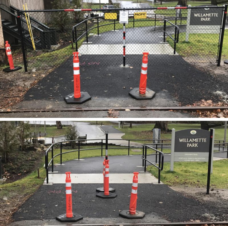
(Photos from a BikePortland reader)
The Nevada Street entrance to Willamette Park was abruptly closed last week. This path is listed as a recommended bikeway and featured in popular maps produced by both the City of Portland and Metro. The decision by the Portland Parks & Recreation bureau to erect a black, chain-link fence was made without any public warning and it stems from a multi-year jurisidictional negotiation between the Oregon Department of Transportation and the City of Portland that spans more than three years.
“We had no realistic alternative other than to install it.”
— Mark Ross, Portland Parks and Recreation
When we first heard about the fence on Monday we were told by Parks that it was erected by ODOT. But ODOT denied it. Then it became clear that the Parks media relations office had a miscommunication with a staffer and Parks did indeed erect the fence; but only after ODOT threatened to fully close the entrance if it didn’t go up.
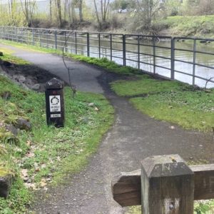
The new fence is just east of the Willamette Shore Railway railroad tracks (which you can see in the photos). It has poles buried into the ground and spans a few feet beyond the paved path. It’s wide enough to make you stop and take notice, yet narrow enough to walk (or bike) around it. In an official statement, Parks refers to it as a “temporary” fence.
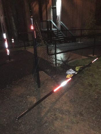
And as of last night, the fence has been removed. This time no agency is to blame. It appears a vandal loosened the bolts and tore it down.
In trying to figure out what the heck is going on, I’ve learned a few things that might shed light on why this happened and what to expect going forward.
First, ODOT is involved because their Rail and Public Transit Division regulates (either completely or partially) every one of the over 4,000 at-grade rail crossings in the state (this three-page PDF explains more about their role). This particular crossing has been on the radar of the City of Portland and ODOT for over three years. That’s about the time when the Portland Water Bureau began to eye a project to build a new pump station in Willamette Park just a few yards away from the Nevada Street entrance. The need for crossing improvements that led to this kerfuffle are tied to that pump station project.
Unfortunately for Parks, they’ve gotten the brunt of the negative PR fallout from all this because they manage the path and entrance that had been closed (the miscommunication between Parks’ media office and a project manager that led to their initial assertion that ODOT erected the fence hasn’t helped them either).
Mark Ross, public information officer for the Parks Bureau shared with us today that, “The way the fence came to be was an anomaly and very unfortunate. We prioritize safety, and will of course work to ensure that a similar situation does not occur in the future.”
In case it wasn’t obviously already, a big reason for this mess is because there are so many cooks in the kitchen. That is to say, it’s the perfect storm of jurisdictional red tape. We’ve got Parks in charge of the path and entrance, the Water Bureau in charge of the pump station, the Metro-run Willamette Shore Railway watching over the tracks, the Portland Bureau of Transportation in charge of the sidewalk and street west of the tracks (but the improvements are the Water Bureau’s responsibility because of the pump station project), and ODOT Rail who regulates the crossing.
Once the Water Bureau flagged this crossing for improvement, ODOT began to look at it more closely. According to a response from a Parks employee to a citizen complaint filed on PDXParkscan on September 8th of 2017, the path was ordered to be closed by ODOT, “citing safety concerns about the… crossing.” We’ve since learned that ODOT ordered the closure as far back as last summer.
Advertisement
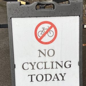
The City first complied with ODOT’s concerns by placing a-frame barricades at the entrance. But those were routinely ignored and moved aside by park users and as ODOT worried about safety and liability, they strongly urged Parks to erect a fence. If Parks didn’t, ODOT said they’d close the Nevada Street entrance permanently and order the path that feeds into it removed. “We had no realistic alternative other than to install it,” Parks’ Ross said.
Now, what will it take to re-open the path?
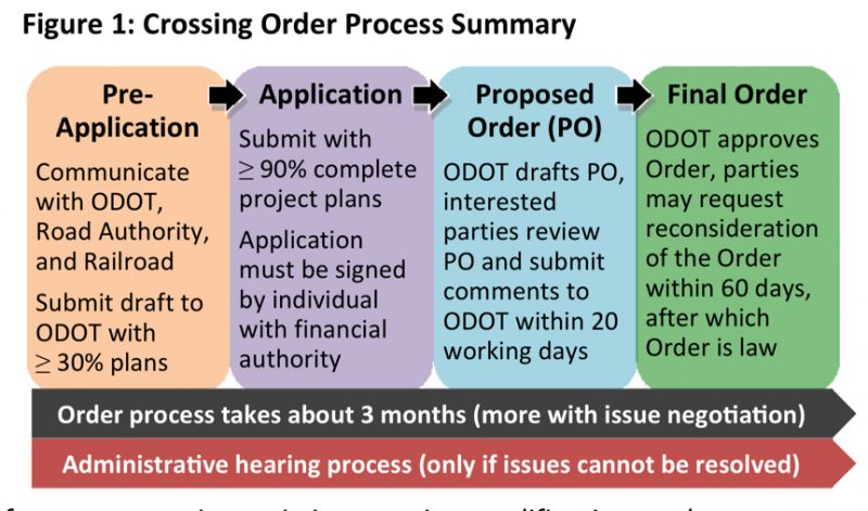
When a local entity (county, city, etc…) wants to modify an existing at-grade railroad crossing, they must apply for a Crossing Order through ODOT’s Rail and Public Transit division. ODOT defines Crossing Orders as, “laws that not only specify what is to be constructed at a crossing, but they may also close crossings, suspend operations of railroads or road authorities, levy fines, authorize investigations, and authorize changes to Oregon Administrative Rules.” That process from application to granting of an order usually takes about three months.
According to ODOT public affairs, the Portland Water Bureau just applied for a Crossing Order in the first week of January 2018. Asked why they hadn’t applied until now, Parks Bureau PIO Mark Ross said the agencies have been meeting and discussing the crossing upgrade requirements for over three years now.
Shelley Snow with ODOT Public Affairs told me in an interview yesterday that ODOT had a meeting last week to discuss the application. It was in that meeting that ODOT, Snow says, “strongly encouraged” Parks to install the fence. Snow also shared that the Water Bureau’s Crossing Order application “needs some work.” She described the scope of improvements the City must make in order to receive ODOT’s blessing as, “pretty large.” Sidewalks, curbs, and gutters must be rebuilt and upgraded, there must be new signage and a variety of safety railings, “to bring it up to standards to prevent someone from crossing and being killed.”
To get an idea of what’s typically required by the State for at-grade crossings, Snow referrred me to Oregon Administrative Rules 741-110-0060 (“Required Installation of Specified Protective Devices”) and 741-120-0025 (Sidewalk Construction and Maintenance”).
So we have a situation where the City proposes designs and then ODOT reviews them, makes changes and suggestions and sends them back, and the negotiations continue.
It’s still unclear what the full scope budget for the improvements might be.
In a statement released Monday, Parks said they anticipate that the permitting process could go into spring. That means any needed construction would happen in summer at the earliest and the issues could persist for many more months.
At this point the fence is down. And Parks doesn’t appear to be eager to replace it. “We are evaluating how to address this,” Ross says.
Stay tuned.
— Jonathan Maus: (503) 706-8804, @jonathan_maus on Twitter and jonathan@bikeportland.org
Never miss a story. Sign-up for the daily BP Headlines email.
BikePortland needs your support.


Thanks for reading.
BikePortland has served this community with independent community journalism since 2005. We rely on subscriptions from readers like you to survive. Your financial support is vital in keeping this valuable resource alive and well.
Please subscribe today to strengthen and expand our work.
Again, why not just stop the trolley south of this entrance until it’s done? There are several hundred people going in and out of this entrance for every trolley passenger.
And the trolley doesn’t even make regular runs until summer anyway.
I asked about this. Was told it’s likely that as long as the tracks and the crossing exist, the safety regulations would apply — regardless of whether or not there is actual active train/trolley traffic. That made sense to me, given how cautious state/federal regs and lawyers generally are.
There are also cultural factors at work here. Railroad tracks are at the top of the heap in terms of respect and power when it comes to these conversations and bicycle users are often at the bottom of that heap.
Sounds like full-on BS to me.
“…as long as the tracks and the crossing exist, the safety regulations would apply — regardless of whether or not there is actual active train/trolley traffic. That made sense to me…”
Apologies in advance for any implicit snark, Jonathan, but: Franz Kafka could craft an excellent little story out of this.
Recent history conflicts with the answer you were given. Before the fence, there were temporary construction barricades put up, but they didn’t appear until this summer. Prior to that, there was some time between the pump station being completed (around end of spring) and the new asphalt path (that leads to and from the crossing) being open for use.
And prior to that, during the pump station construction that lasted a couple years, that crossing was used every day by trucks and workers as the main construction access. For much of that time, access for the public over the tracks in and out of the park was also maintained, parallel to the construction access.
So you were told that this permit/situation has been an issue for about 3 years, but during that three years up until this summer, full crossing access was allowed up until the barriers went up this summer. So if the regulations applied, they weren’t being enforced by ODOT or anyone else until this summer.
The trolley stopped running north of the Sellwood Bridge a few years ago when the tracks between the bridge and SW Miles St. were removed to create bridge construction access. The track replacement was finished at the beginning of this year, and the trolley and maintenance rail vehicle started making runs north of the Sellwood Bridge up to OPB just north of Miles. There, a metal clamp was installed on the tracks to mark the north limit of where the trolley was allowed to run, because it didn’t yet have approval to go further. That approval was granted (and the clamp removed) several months ago.
What all that means is that not only was ODOT allowing people to cross at Nevada for most of the three years since this permit issue apparently arose, it was even allowing people to cross for several months after the trolley started running again through the Nevada crossing.
So the reality is that ODOT definitely DID allow crossing without the trolley running for more than two of the last three years. That shows that even if the regulations applied, ODOT had the discretion (which it used) to suspend enforcing them. And beyond that, for the several weeks or months between the trolley and maintenance vehicle starting runs in spring, and the barriers being set up in summer, ODOT was even allowing use of the crossing while rail use WAS present.
So the answer you were given makes no sense.
The crossing could have been grandfathered in from more recent crossing rules. If the line went inactive at that crossing, it may not change the status of the crossing itself. If that’s all true, ODOT wouldn’t have had to enforce the rules before now because the crossing was grandfathered in or the line was inactive at the crossing.
My guess is that ODOT stepped in only when the Change Order was submitted because the crossing would then be no longer grandfathered in.
You are absolutely correct in asserting that “railroads are at the top of the heap.” There is an old saying that “Most agencies recognize that railroads are next to God in authority, but railroads object to that characterization.”
Incidentally, the bus stop taking everyone from downtown to Willamette Park for the summer concert series stops on SW Nevada and everyone enters the park at that crossing. I’ve seen whole buses empty out at that stop in the summer. This is going to be a big problem.
Also, I empathize with what I’m guessing the vandal’s aims were, but I hope ODOT doesn’t order this fence replaced with something tougher to cheat past.
I’m puzzled. I haven’t been at this crossing in particular, but the crossing of the same track South of there by the West-side bike path, just North of the Sellwood Bridge, seems quite simple: no fancy safety devices that I recall. Is that crossing appropriately permitted, or will it be fenced as well?
Hi James,
I asked ODOT about this. If someone had a project that touched the crossings at Miles or Nebraska, the same situation would arise. In other words, it’s typical with stuff like this that upgrade requirements and new regulations only become triggered when an entity wants to make a modification to the overlapping/adjacent property.
An example is when PBOT wants to build a bikeway in southwest hills they often have trouble because the project triggers huge and expensive requirements for stormwater treatment that must be done. The SW Capitol Hwy project is perfect example…that took 25 years to finally start and coukd cost around $16-20 million!
Perhaps my syntax was too mangled to understand. I meant the track crossing where the newly-reconstructed bike path crosses the new-reconstructed tracks literally just north of the newly-reconstructed Sellwood Bridge. Surely that triggered some reviews, and yet the crossing does seem very simple.
Good point, it’s an entirely new path, and the rails were also completely rebuilt. It has pavement markings and small signs on each side, but I think that’s it. And both locations serve the same trolley.
There’d be some irony involved if more than that was required (talking about signals, signs, etc. and not sidewalk/curb/etc. improvements) given that tens of thousands of people cross much busier streetcar tracks downtown everyday with no elaborate safety paraphernalia, and in the midst of a much noisier, more complex environment. I realize the regulations are probably different.
James, you comment makes me think–there’s an even better example near yours, where as part of the same bridge project the new trail and rebuilt rails cross the new houseboat driveway. That crossing also has just pavement markings and metal signs–nothing elaborate. And unlike this Nevada crossing, it also involves cars crossing as well as bikes and pedestrians. And new drainage, lighting, etc. AND it’s in an environmental area.
Both those crossings are at least as complex in terms of both number of entities, and work required, as the Nevada crossing, but were done in a workmanlike manner by the bridge project. I’m getting the feeling Parks is really overstating the complexity of this, in order to excuse away the current situation. It’s really simple work that shouldn’t still be taking several years to complete.
So, according to the Parks’ own website, the citizen comment which initiated this mess was made 3 days AFTER the decision to close the path was made. How does that make sense?
I’m assuming you’re talking about that Park Scan link. The mess started years ago according to the article. The decision to close the path was made at least a month before the citizen’s September 8th comment. In fact, the citizen was asking about why the path had been closed “for about a month”. How can you interpret someone asking why the trail was closed as “initiating this mess” of the trail being closed?
And where do you get that the decision to close the path was made three days after the citizen’s comment, when again, the citizen was asking why the trail had been closed for a month?
Meanwhile cars parallel park nearly ON the tracks outside the Sailing club on Beaver Ave north of the park (at least per google streetview). Maybe a more useful place for fencing?
There is a book by Historian Joseph Tainter titled ‘ ” Collapse of Complex Civilizations.” It describes how most historical civilizations from Rome to the Mayans began to increase complexity as a way to solve the problems they encountered as they grew. At some point the complexity becomes massive and counterproductive and there is not enough money or energy in the civilization to maintain it, so the civilization collapses back to a simpler level that can be maintained with availible resources. This Gate saga as described above reminds me that such a dynamic is certainly at play today.
Sounds like America. Grandiose schemes to “make America great” but lacking in money, plans and commitment.
It sounds like the difference between liberals and conservatives, on several levels.
“the difference”
?
can you explain?
I imagine he was inferring that conservatives would rather see a more survival of the fittest and less civilized society while liberals seek to create social structures that benefit not just the individual.
Dumb
I thought these tracks were abandoned. Maybe they should be signed “bikes may use full track” to create a shared-use route for train / railbike / bike. Just put in a 4-way stop here.
There was an attempt to create a shared use path in the right of way, adjacent to the tracks about ten years ago. I was on the citizens review committee. The property owners in Lake Oswego adjacent to the right of way managed to kill it. It was my first time participating in the public process and left me questioning the whole process in disappointment. It appeared to be window dressing over a less than transparent process.
>>> If Parks didn’t, ODOT said they’d close the Nevada Street entrance permanently and order the path that feeds into it removed. <<<
How can ODOT order Parks to do anything?
It’s an active rail line under Federal rules which ODOT has to enforce. Federal rules don’t appear to make any other distinctions, and apparently the only way to make a line inactive is repair or decommissioning. Doesn’t matter if a train hasn’t run across the tracks in 20 years – active is active.
Any accident at that crossing would likely get the NTSB involved as the primary lead since it involves passenger rail (depending on how the operator/line is classified), and they are not a fun organization to deal with.
Good heavens, somebody tell ODOT it’s not a 24-hour, 80-mph mainline track, it’s an historical trolley that operates on summer weekends at 10 mph.
Maybe the solution is to turn the crossing into a major urban plaza, then the trolley could safely mix freely with thousands of pedestrians (think PSU plaza with streetcar running through it): http://www.walkermacy.com/wp-content/uploads/2015/11/PSU-Urban_131025_004.png
Or turn it into a main street, and run freight trains down the middle of it, like in Rainier.
(TBH, I like your idea better.)
Jack London Square, Oakland. Hmm, that train looks familiar. &docid=DSp3LseFRwn7iM&tbnid=QpAQNf2EOZ2XvM%3A&vet=1&w=1008&h=665&bih=560&biw=360&ved=0ahUKEwi_yvzt09DYAhUB4WMKHdjHDEgQxiAIJSgF&iact=c&ictx=1
How about some large dayglo orange signs posted on either side of the tracks: “Danger- Railroad Crossing Ahead- Proceed at Your Own Risk”?
Big rail is prob pissed that we hopped tbetween train cars last month…
“a big reason for this mess is because there are so many cooks in the kitchen.”
While that is, essentially, true, I think we should be wary of giving anyone a pass here. The fact is all of these agencies involved have public information officers (or equivalent), all have people whose specific job it is to coordinate with their counterparts at other agencies. What I see is simple ball-dropping, sloppiness, incompetence. Bureaucracies can’t have it both ways: opt to carve up their domain into many tiny pieces, and then throw up their hands when something gets lost.
when did this crossing become unsafe?
it seems to me that this used to be a through street with pedestrian access across the tracks long before the park was there… so it seems that PPR wouldn’t be suddenly forced to remedy something that’s been in place long before the surrounding infrastructure and even the agencies themselves have been around… the only issue seems to be that somebody pointed out something that was never updated because it never needs to be…
how does ODOT have the authority to remove a path inside a park? wouldn’t they just put up their own barrier?
why does ODOT still have so much power to make local entities pay for things they don’t want or need? can’t we tell them to bugger off and close all the freeway ramps?
How is this rail crossing significantly worse that other rails around town? I’m specifically thinking about the rail crossing at Clay and Water, and the entirety of NW 15th ave from Thurman to Lovejoy.
it’s not Dan.
ODOT’s argument is that this one is being scrutinized only because an adjacent project has triggered improvements on it. If a developer or city agency wanted to do a project near another crossing, ODOT would get involved as well. (at least this is how ODOT says it).
If the railway crossings are so contentious, how come we have to cross multiple spurs at 20 degree angles in SW Front avenue ROW, among others. This one is a luxury at 90.
ODOT governs rail lines in Oregon. Rail regulations legitimately have requirements for signs, pavement striping, etc. that typically are on property adjacent to crossings. Parks and PBOT want the crossing, so ODOT is telling them to provide certain things to meet code, the same as the building department can require you to provide certain things you don’t want in order to approve your building project.
Oops–meant as reply to Spiffy above.
I think the issue is whether those requirements are legitimate as applied in this case. It’s a rail line in name only.
Right. Do they control the zoo trains?
It’s a rail line that’s used, albeit very lightly. So ODOT can’t just ignore the lack of permit, signs, etc.
But yes, this is a stupid situation. Regulations almost always have a way for officials to use discretion in how rules are applied. Here, the fence itself is more dangerous than anything, and so is sending people to walk several hundred yards down the tracks, or along Macadam, only to cross the same tracks. It would be safer to let people continue to cross until they do the improvements.
I think one reason ODOT may be acting forcefully is that Parks has completely blown off this situation for three years. Parks has never told the public what was going on. The sign it put up Monday took them 2+ years to put up, and lasted for one day. It sent whole concert crowds over that crossing. It created construction detours for a year that closed legal park entrances and directed people to use the illegal Nevada crossing.
About a month ago, a contractor finishing the handrails on the ramp apparently though the barricades for the crossing were his company’s, and took them away. Parks didn’t bother to reinstall new ones for the whole month, even though Parks staff is right there daily. So ODOT has some reason to be frustrated with Park.
“Metro-run Willamette Shore Railway”
Eh, you might want to clarify that statement, Jonathan. Not accurate at all.
One thing I’m curious about. Last summer the ODOT guy who was at the crossing picking up downed barriers told me that Nevada isn’t the only crossing it’s identified around here as lacking permits. He said there are a bunch of crossings further north towards downtown with the same unpermitted situation.
That area includes South Waterfront. It’d be interesting to see what enforcement ODOT has done at those locations, which could include streets and driveways as well (or maybe more likely than) pedestrian/bike crossings. Is ODOT requiring fencing or stopping use of those, or is it taking a stance that those are more important because they serve vehicles, and the park entrance is just a minor, recreational path?
The shoreline trolley shouldn’t exist anymore. It’s only around to maintain the easements for the ROW. Can we have a bond measure vote to make the easements permanent and turn the route into a MUP? I know the folks in Dunthorpe will sue, but there has to be a legal way to maintain this public ROW without running a train on it a few dozen times per year.
So from what I gather, if a vandal were to disable the useless rail tracks, it’d be a far more effective and lasting solution than taking down the fence.
I fondly remember a time when Portland was, “The City That Works”. My apologies for sounding like a grumpy Oregonian commenter but, the city is now working to make bicycling harder and less safe. The once vaunted MUPs that we were proud of are now poorly maintained linear homeless camps. The car is still king and is seizing more power. Meanwhile, our “advocrats” wring their hands and clutch their pearls unable to fix the bike counter on the Hawthorne Bridge let alone solve any real mobility issues.
so here we are… what a twisted web we weave…
With that timeline, it’s likely that any real closure of this path will overlap with the Springwater closure. Whoops.
PBOT staffers can afford pearls?
I did not know we are paying them so much!
I’m sure I’m not the only person who noticed in the photo that Parks set out the cones only inches from the track, so that if a trolley actually did pass through, it would hit the cones.
That’s on top of what others have said about putting the sign on the fence with small print so that you have to cross the tracks only to find out you shouldn’t have crossed the tracks. It’s like a friend of mine who paddleboarded for years past a grounded ship, always staying well away from it to be safe. One day a sign appeared on it, so he went closer than ever before so he could read the sign. It said, “Extreme danger! Do not come within 100 yards of this sign.”
An opera about our governance:
“The Pearl Clutchers”
Today “SIDEWALK CLOSED” signs were put up, on one each side of the tracks, aiming at people approaching from both directions. The signs are visible and easy to go past, so a big improvement over the black fence. Now if they’d just add an explanation sheet, and check on the signs periodically (Parks staff is there every day) instead of leaving them strewn about for weeks as happened with the previous temporary barriers.
It’s almost become a tourist attraction. When I was walking through there today, someone biked over and said they’d read about it on bikeportland and had to see it for themselves. Next, maybe some “BUILD THE WALL!” protesters for some lively counterpoint…
Tonight the maintenance rail car went through the Nevada crossing about 5:15, then back through it again about 5:30. So in the face of this mess, that’s the response of the trolley line and of Metro, their landlord–send the maintenance car through the crossing twice at the time of day that combines darkness with peak use (everyone biking home out of the park, or coming in on their dog walk or run.
And the regular trolley runs don’t start for several months, so what was the urgency that demanded they come exactly then, and not go an hour or two earlier (so it was light) or later (to avoid peak trail use)?
It’s not that it’s likely they’d hit anyone, but that they’re not willing to make the slightest effort towards safety, right after showing their lack of concern for the public’s safety by putting up the black fence. It’s incredibly stupid PR if nothing else.
30,000 a people year reliably die by car. How many die by people crossing narrow gauge track?
Wait, we should put fence all along the max tracks. Now!!!!
Something might be happening. After several days of cones and barriers moving here and there, this morning a bunch of chalk marks appeared. There are “X”s every 8′ or so down the center of the ramp/path, from the train tracks down the ramp, then turning north towards the crosswalk. Along the edges of the top third of the ramp are white chalk lines every 3′ or so, and those also appear on the east edge of the main trail across from the bottom of the ramp.
Marks for more bollards? Pavement markings or a handrail down the middle of the ramp? Fences on the sides at the top third? A fence or rail at the bottom, so runaway bikes don’t continue into the playfield? More caged rocks?
Two wooden stakes were put in the ground a few feet west (towards Macadam) of the tracks, either yesterday or today. They’re not in the middle of the path, but just stick up a few inches, so not particularly easy to see in the dark.
lol I remember when I took this fence out with a crescent wrench haha give me liberty or give me death
Is the fence still there?