(Photos: J. Maus/BikePortland)
One of the ways I fit cycling adventures into my life is to ride to places where I’m already planning to do something with my family. So, when we planned to meet some friends in Hood River on Sunday, I knew it was a golden opportunity.
Like always, I opened up Ride With GPS and started planning. I ended up doing an absolutely sublime 100-mile route from Portland to Hood River that you definitely want to put on your to-do list (if you haven’t already).

When I plan a route my main goal is to come in contact with as few cars as possible. And by that measure, the route I did Sunday is one of the best I’ve ever done. Most of it was either on carfree paths or mountain backroads with very few motor vehicles. I can’t believe it’s taken me 13 years of living in Portland to do this ride!
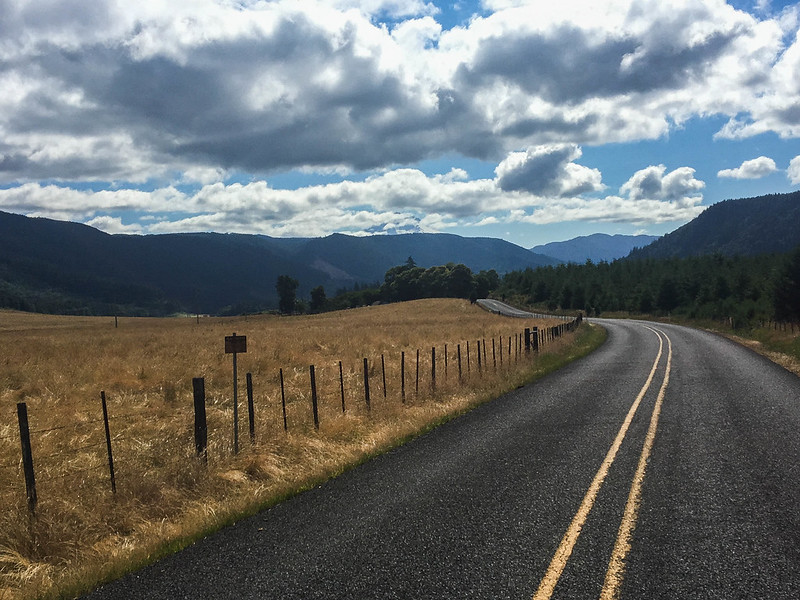
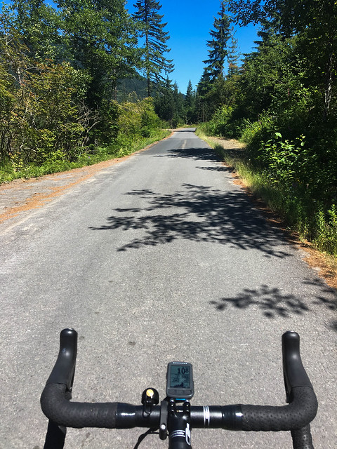
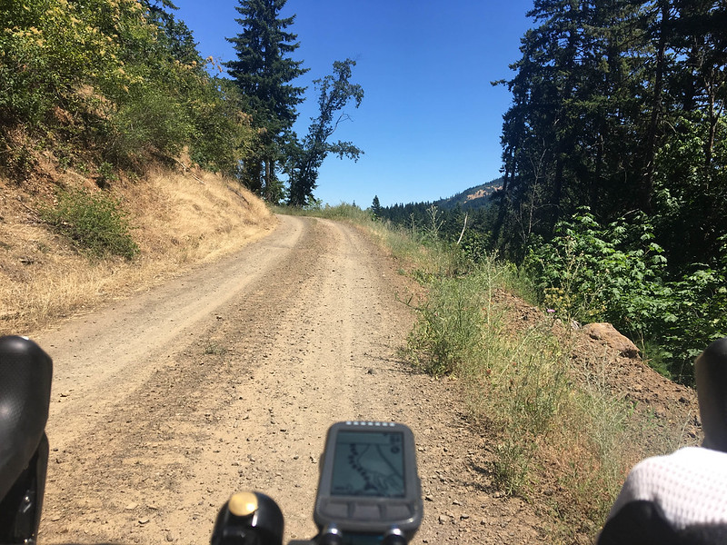
The first 25 miles or so were on the Esplanade and the Springwater. By the time I turned off the Springwater (north of Boring), I was already among rural farmlands with hardly any traffic (especially on a Sunday morning). I headed east toward the Sandy River via Dodge Park Boulevard and Lusted Road. After a water refill at beautiful Dodge Park, a campground at the confluence of the Sandy and Bull Run rivers run by the Portland Water Bureau, I continued east on smooth and winding backroads. SE Shipley Road between Ten Eyck and Marmot roads was a highlight of this section.
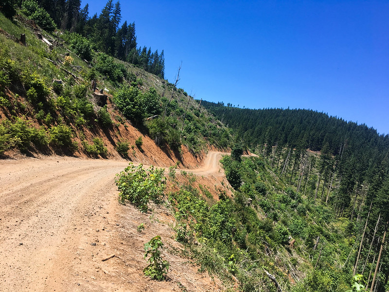
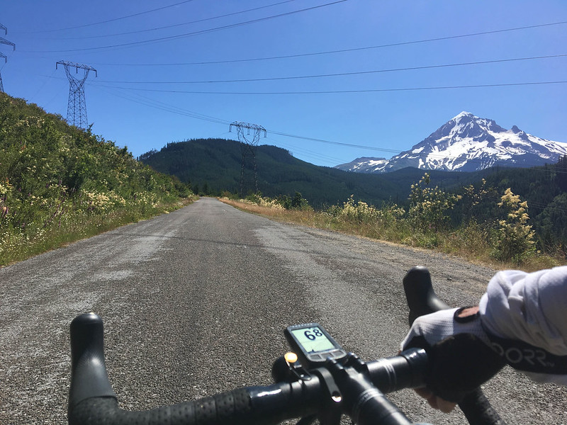
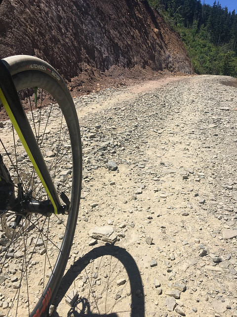
Once on Marmot Road (which is quiet and beautiful) the route paralleled Highway 26 (while being far enough away to not hear or see it) for 14 miles. At tiny mountain community of Zig Zag, I made a left and headed north on Lolo Pass Road. This was the big climb of the day: the road took me 2,000 feet up in about 10 miles. At the top, the road turned to dirt. I crawled my way down about 3.5 miles of loose rocks and gravel (thank goodness I had size 32 tires set up tubeless).
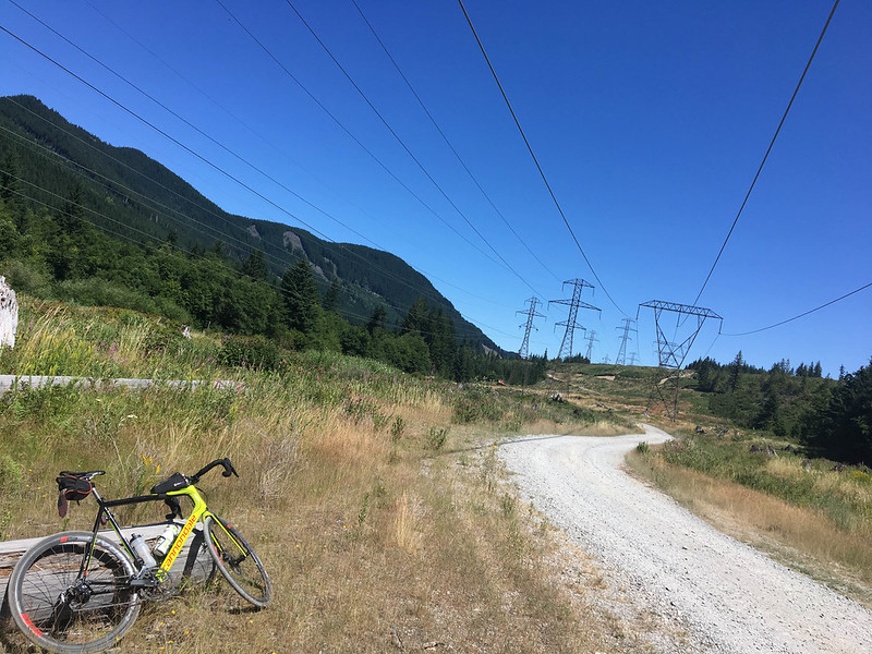
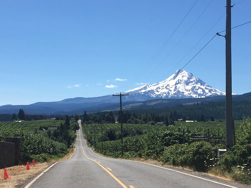
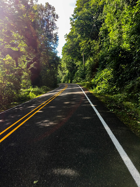
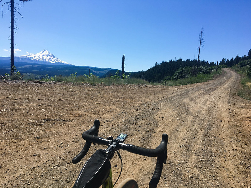
After the dirt section, Lolo Pass turns into Lost Lake Road and I eventually wound my way to the orchards of the upper Hood River valley. Instead of going into town via the popular route of Dee Highway I opted for an alternate: Kingsley Road. I had no idea what to expect, but I’m glad I gave it a try. The four-mile, 1,100 foot climb turned out to be rocky dirt and felt rather steep with 90 miles already in my legs — but it sure beat riding on the shoulder of Dee Highway (218)! And the paved descent on Kingsley back to the highway was smooth, fast, and perfect.
I can’t recommend this route enough. And keep in mind you don’t have to do the 100-miler all the way to Hood River. This route is a great way to get from Portland to Dodge Park for an overnight bikecamping trip. Or do the Kingsley-Punchbowl Road loop from Hood River. Check out the route on Ride With GPS.
— Jonathan Maus: (503) 706-8804, @jonathan_maus on Twitter and jonathan@bikeportland.org
BikePortland is supported by the community (that means you!). Please become a subscriber or make a donation today.


Thanks for reading.
BikePortland has served this community with independent community journalism since 2005. We rely on subscriptions from readers like you to survive. Your financial support is vital in keeping this valuable resource alive and well.
Please subscribe today to strengthen and expand our work.
Sweet looking route.
I ride 23 slicks so the gravel wouldn’t be awesome, but looks like it would still be worth it.
with 23s i would avoid the Kingsley option and just stay on Dee Hwy into town. And you could walk/roll the Lolo Pass dirt section… just make sure to wear comfy shoes!
I really like road 1828, which parallels Lolo Pass Rd and happens to be paved and shaded. It starts arounds McNeil Campground and brings you to Lolo Pass where it crosses the PCT.
Thanks for the ride report Jonathan. Riding Lolo pass to Hood River has been on my to do list for a few years.
that sounds good. I want to go back now and do more exploring and more loops. Ideally I’d ride out there… find a place to sleep… and then ride some more… and then ride home.
This was used in this years Mt Hood Gravel Grinder Ride. Some very sizable pot holes (aka entire width of the road) to watch for but I agree it is an incredible alternate road, very narrow and shaded. Dumps you back into Lolo pass rd right at the top by PCT.
Or change your tires, doh!
I have so little clearance I might be able to fit 25s, definitely not anything bigger.
They work better than most people would guess, though it’s not very fast going.
I went to wide rims (Pacenti SL23s, and Sugar just finished a set of Pacenti Forza), and the difference was noticeable. The contact patch widens, and 23s look like 25s but ride like 28s. When I recently switched back to Ksyriums, they felt lighter and faster at first, but descending felt less confident, and Strava didn’t show any difference in my usual speeds.
And contrary to the current “gravel grinder craze” you can ride many (if not most) dirt gravel roads on 23 or 25s. We used to just call that riding.
Seems really dangerous if you don’t have a bike with gravel-specific geometry. And rim brakes? Are you insane?
Hydraulic, because mechanical discs are just too risky.
disagree.
(it’s a joke… 😉
whoosh right over my head!
So you’re telling me I should be rocking a fat bike?
I grew up underbiking, and going fatter makes all the difference in the world. Way faster going up and waaay faster going down rougher stuff. I now seek out gravel above all. Compass makes some amazing tires in heretofore heretical sizes that are only going to get more popular as people discover fat doesn’t mean slow, especially if the tires are #supple. Beyond sizes like 650×42 and 48, there are now even production all-road bikes built around 26×55, which seems crazy but is actually plush and fast. Roughly same OD as 700×25, just a lot more suspension and less wheel weight and inertia.
Definitely agree that you can go faster with wider/bigger tires.
There’s a big difference between riding gravel/dirt and having sections of that stuff on a ride. Also, the range of bikes that can be used depends on the specific road conditions and rider.
BTW, loose gravel is outright fun on recumbent trikes, particularly if you have switchback curves to descend.
Agree, my bike with roadish geometry running 2.25″ tubeless tires flies on pavement but is untouchable on gravel. I like to hunt for good photo angles of my friends coming down fire roads and dirt trails while I’m inevitably waiting for them to catch up. It’s also a good time to grab a snack.
There’s a big difference between riding gravel/dirt and having sections of that stuff on a ride. Also, the range of bikes that can be used depends on the specific road conditions and rider.
BTW, loose gravel is outright fun on recumbent trikes, particularly if you have switchback curves to descend.
So beautiful. Thanks for giving me something for my to do list.
looks like a perfect ride, thanks for the post!
I cannot wait to ride this!
Major kudos, thanks for sharing!
Did the lolo pass portion on 23’s one year; I got away with it but I would alter my thinking moving forward!
Great writeup, great Century!
Yes, I’ve done it on slick 25s before – kind of like walking in high heels on ball bearings, but in a group of 5 riders, no one had any flats, even though there was some pretty spirited riding.
I mapped almost the same route on Ridewithgps a few weeks ago…looks great…
Looks like an excellent trip thru some fine Republican country. I guess you’re used to the road bike, but I’d prefer a mountain bike – even if it had those smooth Serfas tires with the inny tread (as opposed to outty tread).
Sold… I want to do this as well.
What did you do for water?. I took a similar ride a couple years ago, it was >100F, and I ran out of water with two hours to go.
There are lots of options. Churches are great because they have outdoor spigots, but if there is anyone living out there, you can simply ask — I’ve only been refused once in my entire life because the lady thought it was a scam to get her to open the door. If you pass by no houses whatsoever but you pass by any kind of stream or other water source, carry a filter. You can also carry a lot of water. Two big bottles plus up to 100oz camelbak even on a race setup, or if you have a rig that takes panniers, lugging a couple gallons is doable.
Definitely don’t run out of water. Good way to collapse from heat exhaustion and wake up by the side of the road.
I battle atrial fibrillation now because of episodes with heat exhaustion, so I can’t stress your advice enough. I also use Hammer Endurolyte Extreme tablets, but fully hydrating the day before a long, hot, hilly ride like this is critical. (I’ve also learned that alcohol, jet lag, stress, and other factors can contribute to dehydration, subtly).
Heat exhaustion is serious stuff and you become more vulnerable once you’ve had it. It’s important to pay attention to hydration, pacing, and electrolytes.
One dead giveaway is it can make you feel like you’re freezing. You might also find that you can’t consume anything — not even water. It sounds like it would be easy to figure out something’s wrong, but unfortunately your head and judgment also get messed up.
Don’t ignore warning signs, or you could collapse without warning.
I was told a-fib comes back once you get it – four cardioversions later I can attest that’s true. Caffeine especially makes you vulnerable – my downfall was energy drinks. The later episodes were each different in their own way, each time with me thinking I had it under control, and unfortunately couldn’t really tell until after I stopped riding and things don’t come down quite properly. (On the plus side, though, the lovely ER nurse who pressed the button the first time is now my wife).
SAWYER MINI FILTER!! Super easy and super small, I’ve been carrying on all of my “out there” rides where I’m unsure of water. Best $20 I’ve ever spent.
You can also carry a water filter. There are a few stream/river crossings along the way.
MSR Trailshot or Steripen
Great question John. It was hot. But not scorching. I topped off my two large bottles at Dodge Park relatively early in the ride and then hoped I’d find another water source. I never did, so I rolled into Hood empty (after drinking sparingly).
Other commenters are right. Plenty of springs out there. I didn’t bring a filter .. although I almost filled up at a really nice spring that was literally gushing from under a tree root. but yes, lack of services is an issue on the Lolo Pass stretch of this.
Keep in mind though.. If an emergency there are houses you could stop at and ask people to use their water.
You can get water if you ask nicely from residents along Barlow Trail Rd, and if you go slightly out of the way to Hwy26 there’s a ranger station where you can get water and maps.
Unless it’s the weekend or after five PM. Station Rangers work bankers hours. 🙁
I did this ride once and ran way low on water. As I was finally making my way into the orchards above Hood River, I pulled over and stole what looked to be a delicious, ripe, juicy pear. Bit into it, and it was completely unripe, starchy, and dry!!!! I seriously have not been tempted by a pear since, and that was like in 2010 I think.
Fortunately there was a country store another couple miles down the road.
Better leave fruit picking to the experts, apparently.
You also don’t know what stuff on the trees may be sprayed with.
Not that they’d do this with trees, but having done quite a bit of riding with through agricultural areas, I’ve been caught in “reclaimed water” spray many times — get yer probiotics!
6 pack of PBR in the paniers!
https://www.youtube.com/watch?v=56duVYLsd4Q
🙂
I have done a fair bit of this route although the Punchbowls is new to me. I would make the suggestion to get to the top of Lolo and take 1810, it’s a much nicer road that intersects with NF18 further down.
thanks James!
That was on my original route.. but I was up against a time constraint and since I had never done it I opted for the more known variable. Next time for sure.
Plus 1810 is fine on 25’s, has some ridable gravel. 23’s at a pinch.
Beautiful and inspiring. Thanks for sharing!
I think we are just about to make reservations in Portland.
Ehhh, Hood River!
This looks like a fun ride. Will definitely have to keep this in mind.
Interesting diversion out Orchard Rd. in Hood River. Looks like you got headed off by the airport runway extension. It looks like Google maps hasn’t caught up with the change. The street view shows a road where the satellite view shows a break for the runway.
Good eyes Stephen. I sure did. I was trying to cut some miles off Orchard Rd. And yes, my maps must have been out of date. Glad it wasn’t much a trouble… and the extra few miles is what actually helped my odometer tick to 100 so that’s a bonus!
Thank you for sharing! I love your ride reports and wish there were more of them.
Glad you like them Pat. I love doing them.
I’m always planning trips and welcome your ideas for where to go. Right now I’m trying to nail down a trip to Walla Walla to see what they have to offer.
Yes, you should ride in Walla Walla. There are some road rides in the Waitsburg direction. City of Walla Walla publishes a good map. It has routes as well as elevation profiles! Contact gis@ci.walla-walla.wa.us. And get this…..follwing one of the routes on their map,I found public water stops marked with offical county signs. Pretty nice on a hot August day.
Go further east sometime: http://www.adventuresnw.com/ride-like-the-wind-cycling-the-palouse
Love this, bookmarking for the future!
Is there a decent way to make a loop of this back to PDX through the Gorge? I was considering a similar ride this weekend to get to the Fall Creek Hinterland ride on Sat in Carson, but couldn’t figure a good way to get from Hood River to Cascade Locks/BOG. It looks like the choice are a stretch on I-84 or RT 14 on the WA side. Anyone know of a better option?
If your choice comes down to I-84 or RT14, take I-84. RT14 has almost no shoulder, at the end of the day it will be hard for cars to pick you out due to the setting sun, and there is debris from small slides on the shoulder – rocks from gravel size up to fist size. Also, there are tunnels. I-84 will at least give you more room on the shoulder and no tunnels.
Plus if you want to get to the Oregon side from Bingen, you’ll have to hitch because the HR Bridge bans peds and cyclists (and you’d be crazy to try it anyway).
Until ODOT completes the final portions of the Historic Columbia River Hwy State trail, you’re forced to ride I-84 for about 11 miles between Hood River and Wyeth. It’s legal, but I’m not sure I’d want to do it. Nor would I want to be on the WA side of the river on SR14.
http://oregonstateparks.org/ckFiles/files/HCRH_BikeMaps.pdf
I’ve done this, and it wasn’t all that bad in my mind. You are on a huge shoulder, and while traffic is moving fast, highway drivers tend to hold their lanes, especially when there are rumble strips (if I’m remembering correctly, they are common on I84 around there).
And then once you can connect to the paths and old highway things are golden.
We live in very different worlds, it seems.
A beloved local cyclist was killed riding this stretch a few years ago…so I might be a bit more sensitive about riding it than you. https://bikeportland.org/2014/08/27/fatal-collision-highlights-gap-historic-columbia-river-highway-state-trail-110428
I travel between HR-PDX on 84 regularly, and can’t tell you how many times I’ve watched the 2nd or 3rd trailer of a semi wobble over onto the shoulder.
All in all, it’s probably not much more dangerous than many routes in Portland. I agree that we live in different worlds…I generally encounter less than a dozen cars on my road rides.
On the back wall of Celilo restaurant there is an extraordinary work of her art (I believe Maui and Ben and Jacquelyn brought it over from Sixth Street). I think of her every time I see it. I didn’t know her personally very well (friend of friends), but she was a vibrant woman to be around. Tragic loss to the entire community.
What makes riding on the shoulders of freeways bad isn’t traffic, but rather debris and crossing on/off ramps. In the case of 84, wind can be a huge issue (though it could also be a tailwind).
My experience is that traffic drift is less of an issue on interstates than other types of highways. On the plus side, you can get an excellent side draft off heavy traffic. It’s not that fun, but you can cover a lot of miles fast.
I appreciate the mansplain, but I don’t even like riding in bike lanes next to 30 MPH traffic. There is absolutely no way in hell I’m riding on the shoulder of a highway. The roar of the cars along would probably induce a panic attack.
It’s totally obvious to me why someone wouldn’t like riding by the roar of highway traffic. It is really loud. But it’s not as dangerous as many “normal” cycling environments except when crossing ramps. Sight lines are excellent, threats from the side are nonexistent, and the shoulders are super wide. Hook threats are nonexistent — problems only come from behind
Along interstates, you ride much further from the white line because the blast from trucks is hefty. That means that for a cyclist to get hit: 1) a vehicle has to be 5 feet or more into the shoulder where drivers who’ve dozed off will get loads of tactile feedback (how often do you see this, seriously); and 2) the cyclist doesn’t notice or doesn’t have time to bail.
The reason it’s legal to ride along certain sections of in Oregon is because it’s considered safer than alternatives. If you want to go places on a bike, it is frequently the case that there is no easy and pleasant option.
Is this even a ride you are interested in (setting aside the safety issues on 84)? Based on your comments on this site, my impression that your interest lies primarily in commuting and around-town toodling.
I would suggest that if that is the case, your opinion on this ride in particular bears little relevance.
It’s intimidating, but do-able. Problem is that those shoulders are rarely clean of debris. It tends to be cleaner westbound (and downhill), though gusty.
I was thinking about the intimidation thing because vehicles go nearly the speeds on many two lane highways as they do on interstates and shoulders aren’t nearly was wide (or might not even exist).
I used to ride between Monmouth and Eugene on an occasional basis for work and have done it via I-5, 99, and back roads. The back roads are by far the most fun, but they take significantly longer, I-5 is fastest, and 99 is somewhere in between. From a safety standpoint, 99 was the worst by far. There are some sections with no shoulder at all, and traffic is heavy and fast.
My recollection was that the biggest single drawback I saw to riding I-5 was the debris followed by the noise. Safety wasn’t a significant concern. It is a major concern on some two lane highways and it can be an issue even on back roads.
There are a bunch of roads that look like they’d be great for riding but are quite dangerous. Near the coast, there are a bunch of curvy back roads with really light traffic. Problem is that the locals and some tourists use them for a Mario Andretti driving experience.
Oooof… I lived in Corvallis and rode 99 to Eugene once. No shoulder and buzzed by speeding cars from what I remember.
Also, don’t be fooled by the Ride-With-GPS suggestion to climb up Wyeth Trail #411 to NF-2820. The Wyeth Trail is under US Forest Service “wilderness restrictions,” which, among other things requires a permit and prohibits “possessing or using a… bicycle” (see https://www.fs.usda.gov/detail/mthood/specialplaces/?cid=stelprdb5192346). I realize this may be a politically sensitive subject and I’m not trying to pick a fight with anyone. I simply don’t want people to be surprised by such rules. Unfortunately, the Google maps routing engine does not do a good job of distinguishing protected trails from those that allow bike-access.
“Is there a decent way to make a loop of this back to PDX through the Gorge?”
No.
West of Wyeth, yes. The freeway shoulder might be “wide” most of those 10-12 miles from Hood River to Wyeth, but not around Shellrock Mountain. That’s where you’re going to die.
An alternative that might work, if you’re not an anti-car purist: I believe there is a taxi service in Hood River. If I’m not mistaken, cyclists sometimes use it to get across the bikes-prohibited bridge over the Columbia. I wonder if you could get them to drive you and your bike to Wyeth. Might cost a few bucks, but would totally be worth it.
https://www.youtube.com/watch?v=mt1icFkkzUM
Good luck with the “cab” companies here…
Awesome route! I’ve done most of it, but we crossed over Vista Ridge/Red Hill (USFS 16, 98% paved) to come out in Parkdale and then across to the east side of the valley to avoid Dee Hwy down to Hood River (Note that this adds another serious climb and
some distance).
https://ridewithgps.com/routes/23268310
A couple others have mentioned the alternate climb and descent of Lolo Pass. The alternate climb adds about 3 miles, but it’s much better cycling road (Narrow, twisty pavement…and even less chance of seeing a car compared to Lolo Pass Road). When you meet Lolo Pass road at the top take the 1810 down. While gravel, it’s in better shape than Lolo Pass road. Here’s the map:
https://ridewithgps.com/routes/23267987
Just a thought: If the Trans-America trail ever gets to Oregon, this could be an alternate to the Columbia Gorge trail. Adding water stops, rain shelters and signage to this might be worth considering.
JM,
you should make this an annual group ride 🙂
I’d love to. Have actually thought a lot about doing “BikePortand Rides”. Would be a great way to share roads and get to know readers better. Might have to make it happen.
Talk to Chad Sperry or Kendra Wenzel or Julie Wilson for some tips. Now that the Tour de Hood is gone, there is definitely a gap, and this is a great variation to some local routes (that I’ll have to try soon).
Check out the Oregon Gravel Grinder Series! 3 Grand Fondos and the one around Mt Hood used the smaller Forest Service roads along this route. The events could definitely use more participation to be sustainable.
Yeah, one of Chad’s new gigs, so it has to be good! Haven’t had a chance to make it yet, but after seeing the video with the tandem, we’ll have to start training for next year now…
I’d be happy to help with the planning 🙂
My buddy Scott and I have discussed starting a partially supported, mostly gravel route. Basically, someone drives your stuff from point to point and picks up food/beer. I think there is a market for this. The Mitchell area has been an area of focus for this – with the Spoke’N Hostel and Tiger Town brewing there.
I’ve got an old extended-length cargo van…
(Once carried seven bikes/cyclists from BMC Racing out to TD for the Mt. Hood Classic time trial in it, so there should be some space for beer).
“Cycle Oregravel”
Love it. Stay the night in HR then take the Columbia Gorge Express back into town (someday soon), and it’d be amazing.
Someone go make it happen!
“MCEDD is seeking a Mobility Manager to support the Gorge TransLink Alliance. Learn more at mcedd.org/jobopenings.htm
CAT is seeking an Executive Director. Learn more at catransit.org.”
Oh yeah, on Tuesday and Thursday mornings you can catch CAT into Portland ~8 AM on Wasco by the Walmart.
http://www.gorgetranslink.com/regional-thedalles-hoodriver-portland.html
I do this ride in the reverse direction usually at least once a year. I live in The Dalles and start out riding the Old Highway up the Rowena Loops and then over the Twin Tunnels Trail between Mosier and Hood River. I then turn south and ride on the east side of the Hood River Valley on Eastside road. The Kingsley Road option is an interesting one – Skipping the Dee Highway is a wise decision considering the not-always-so-considerate highway traffic that rushes along it. Riding “toward” Portland via this route and riding along Barlow Trail / Marmot Roads is really nice.
Thanks for the report.
JM did it in the ‘kinder’ direction; climbing up Kingsley or Binn’s Hill Road from Hood River’s westside heading S/SW are some pretty challenging hills! (But then again Sevenmile from TD isn’t a cakewalk either…).
I’ve done the Lusted/Marmot stretch (going out to Welches) and it’s pretty nice. I remember very few cars, and half a dozen calves curiously running along a fenceline trying to follow me (but as soon as I stopped and looked back, they would run away).
How many orchards did you pass? Might be good to time the ride for when they are blooming if there’s not too much snow on the high parts.
I hope you’re out there doing more beautiful rides, Jonathan.
As a frequent critic/skeptic, I just want you to know that this is exactly the kind of BikePortland post that I miss.