The contours of conversations about how much space should be given to various users of the new Hood River-White Salmon Bridge are quickly coming into focus. Members of the Columbia River Gorge Commission where given an update on the project this morning and some of them see a red flag in the lack of space initially allocated toward non-car users.
Washington and Oregon have decided to spend an estimated $520 million to replace the current bridge because it’s over 100 years old, is quite narrow, and has no dedicated space for bicycling or walking.
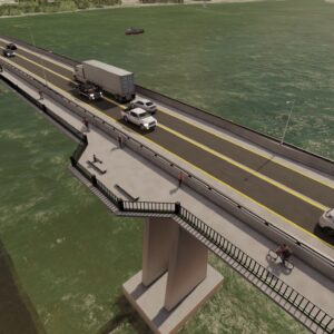
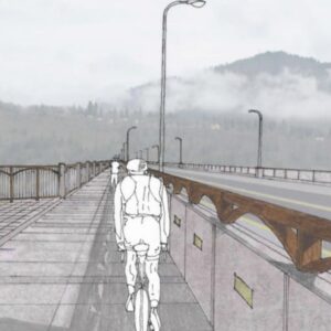
Planning work began in earnest in 2018 and BikePortland first covered the project in 2020 when it reached a major planning milestone. From the get-go, some advocates worried that the conceptual design language called for only one 12-foot-wide path to serve two directions of cycling, walking, and other non-car users. That one path would be adjacent to 40 feet for drivers who would have two, 12-foot lanes and two 8-foot wide “breakdown” shoulders (so people could move aside and let traffic get by in the event of a fender-bender or other emergency).
The Gorge Commission was shown a presentation by Michael Shannon, a project manager with HTNB Corp, an engineering consulting firm. Shannon shared a new digital video of a conceptual rendering of what the future bridge could look like.
After seeing the presentation, Commission member (and former Metro Councilor) Robert Liberty raised his hand. He highlighted the management plan for the project that mandates the new bridge, “shall include facilities for pedestrians and bicyclists that are be wide enough to safely accommodate and encourage walking, bicycling and other uses.” Liberty then explained that a standard width for bike lanes on bridges is five feet in each direction and another five-to-six feet for pedestrians.
“So that’d be 15 to 16 feet, but the rendering and the cross-section state 12-feet. When the [Historic Columbia River Highway] bike trail on the [Oregon] side is completed, the volume of traffic is going to be considerable,” Liberty said. He then painted a picture of bike riders mixing with walkers and groups of people posing for a family photo.
In response, Shannon said it’s a challenge to balance all the needs of the project with a fixed budget. He added that the width of the bike path has been a “topic of discussion” and he assured Liberty that the designs shown today are merely at an early, 5-10% level of detail. “There will be more design refinements to look at on that,” Shannon promised.
Shannon also acknowledged that bridge engineers have flexibility when it comes to lane widths. He said they could consider adjusting the width of the shoulders to give more room to the path. Another option he mentioned was creating a bike lane on the main bridge deck that’s, “More geared toward e-bikes or the professional road users who don’t really like to be mixed in with the pedestrians and casual recreational users.”
It’s unclear why Shannon referred to some cyclists as “professional road users.”
The project currently has $119 million in the bank ($80 million from Washington, $25 million from Oregon, $14 million from federal government) and needs $400 million more — including $105 million from Oregon.
The current estimate for the bike/walk path is about $50 million.
While Liberty appears to be ready to champion a significant increase in the width and quality of the path, two members of the public who spoke during the open comment period shared a different perspective.
“The main purpose of this bridge is to move cars. It’s not to move people and bikes and everything else,” said a commenter named Mary (who also objected to the planned tolls that will help maintain the bridge). “It’s a crossing that is needed for economic reasons, but its main purpose is moving cars and trucks to keep commerce going.”
Another woman agreed with Mary, saying, “The principal responsibility of the bridge is to move traffic, it’s not to be the Golden Gate Bridge or whatever… it is for the most movement of transport and commerce and people who want to move from one side of the Gorge to the other for purposes of returning home from shopping or moving visitors to the area from one side to the other. I can’t imagine that a lot of people are going to be stopping at one side of the bridge or the other to take a photo.”
Shannon said the project hopes to have a final environmental impact statement and official “record of decision” from the federal government by spring of next year. Construction would then begin in fall 2025 with the final design in place by the end of 2026. The new bridge is expected to open in late 2029.


Thanks for reading.
BikePortland has served this community with independent community journalism since 2005. We rely on subscriptions from readers like you to survive. Your financial support is vital in keeping this valuable resource alive and well.
Please subscribe today to strengthen and expand our work.
The golden gate bridge is actually extremely not nice to bike over. It’s very narrow, and actually has huge areas with no visibility because of the columns, clogged with tourists and people biking of various skill/aggression levels.
https://www.google.com/maps/@37.81324,-122.4777239,3a,75y,152.21h,84.12t/data=!3m7!1e1!3m5!1sAF1QipNdHqOxwRNLI9aBW64e40NLa03HeR8_g5d6HqMi!2e10!3e11!7i11000!8i5500?entry=ttu
That being said, it’s a shame to hear that they’re not more interested in tourism or just building a great place for the sake of it, I’d love to ride my bike out there but right now it’s way too scary.
It’s also only open to bikes and pedestrians during certain hours, right?
There is 24h access for bikes. You need to buzz through a gate after hours.
Pedestrian access is limited to ~daylight hours.
https://www.goldengate.org/bridge/visiting-the-bridge/bikes-pedestrians/
I have a friend that works odd hours (hospital staff) and usually bikes across the GG Bridge to San Francisco. She says you just have to ring a buzzer and not be obviously suicidal on video surveillance (I’m sure being a regular helps) to be let through the gates.
When I rode the Golden Gate in late 2020 it had been divided so that one side was for bikes only and the other was pedestrians. The bikes had the western side with ocean views and the peds had the SF bay side. It was still a little tight for two way traffic, and there were some peds not following the rules, but overall it wasn’t a bad experience, it certainly beats any bridge experience in the Columbia gorge, and I’ve ridden 4 different bridges in the gorge. https://pdxtosfoorbust.blogspot.com/ if you want to see pictures of it from the blog I did of the ride.
I rode it twice, first time in 2010 touring the pacific coast. Not knowing any better we took the bay side, mid-day. Huge mess, trying to squeeze fully loaded touring rigs through the crowds. Whoops!
Did it again in 2021 on rental bikes and while the ocean side was calm, yeah there are a lot of obstructions, construction areas, etc.
It should be pointed out that cyclist also contribute to commerce. Towns that have bike trails in them have seen an increase in dollars from cyclists. More and more cyclists are using bikes as their method of commuting to and from work.
Comment deleted
Bingen businesses stand to gain the most from this, from that perspective, and the town is really starting to come into its own. Crossing on bike there you’d currently not want to head west on 14, but heading east wouldn’t be so dangerous, as there’s a wide enough shoulder and 40 MPH speed limit, and worst case empty sidewalk. Traffic is calmed once into Bingen, and sharrows could be painted. You wouldn’t want to bike further east on 14, especially through the tunnels out by Lyle. You could do the fairly strenuous climb to White Salmon, mixing with fast drivers on a narrow, typically dirty shoulder.
(Aside from tourism, there is a sizeable car-free population living in poverty level in WA who really need at least ped access on this bridge. I should note Mt Adams Transport and CAT are viable current options, with their busses equipped to carry bikes).
Best thing Bingen could do would be to build a MUP all the way into town.
“Professional road users”. Lol. Probably because you aren’t allowed to say “Lycra nerds” in a professional meeting (no hate toward Lycra nerds/professional road users)
I find it funny that this bridge is likely to cost 1/20th of the of the cost of the CRC to cross the same river. Obviously there are major differences between the two, but it’s food for thought on why the CRC is so expensive. Hint: look at all the unnecessary new interchanges on I-5 as part of the CRC.
It’s amazing what can be done when you are actually doing a 1:1 replacement and not trying to hide a massive freeway expansion as part of a “replacement” project.
Or a massive light rail expansion? /devilsadvocate
Says who? The management plan literally mandates facilities to move people and bikes and everything else, as it should.
What does she think the people who would cross this bridge on bikes are doing?
I love when car-brains pretend all motorists are doing very important commerce business and no one ever drives for recreation or to access non-business related things.
That kind of outlook is so infuriating. It’s unbelievable. She’s saying that the river is un-crossable unless you’re in a motor vehicle. If you want to get across it, you need to somehow get someone to drive you and your bike across. This is an insane, backwards, mind boggling view of the world that makes the river a hard barrier to bicycles. It makes no sense and really, it sounds like she seriously hasn’t put forth any thought at all.
She’s put plenty of thought into it, she doesn’t want any bikes in her way, ever.
The current bridge is indeed uncrossable if you’re not in a car or truck. I’ve lived in the gorge for decades and can’t even count the number of people there who don’t own cars who we pick up hitch hiking on one side of the other.
“I can’t imagine that a lot of people are going to be stopping at one side of the bridge or the other to take a photo.”
Has this person ever looked beyond the bumper of the car in front of them when crossing the bridge? Imagine living in the gorge and thinking people won’t want to stop and take pictures.
The whole time I lived in Hood River (2015-2018), I had no car. I wanted so badly to ride my bike across that bridge. There will be hundreds of people stopping mid-span to take pictures every day in the Summer.
You’re right. My hope is for several “bump outs” that can function as Instagram hot spots. Then people actually traveling can proceed through.
I don’t think this should be the case at all. If you want pictures from the bridge you should have to walk/bike across. Cars should not be stopping at all. (HR citizen, car and road/mtn biker since ’07).
Wholeheartedly agree! There is no reason, except for emergency/breakdown, cars should be allowed to stop. Though I didn’t read Joe’s comment as allowing cars to stop.
Current lane widths on this bridge should be kept the same.
no shoulder for cars.
the new car deck should be steel as it is now.
Add a 16′-20′ wide shared-use path. in steel or concrete.
No separation of lyrca cyclists vs people walking.
Seems to work just fine on narrower bridge in PDX like Steel and Hawthorne
What happens when a vehicle breaks down on the bridge, though? Adding no option for breakdown space or emergency vehicle bypass space would be very short-sighted.
Given the number of cyclists and pedestrians that will use this thing, I think 12ft is fine. This is a very long bridge, with significant grades. There will be minimal pedestrian use.
Why do you think there will be minimal pedestrian use? It’s only a mile-long bridge. The number of people commuting between White Salmon and Hood River keeps growing. If given the opportunity to do so, some are going to walk. (And many more will bike.)
Neither end gets you to White Salmon or Hood River. It’s at least 2 miles, so I don’t think many will be walk commuting. There will definitely be demand for bike commuting, though.
Bingen is at the bottom of the hill. They have a fantastic skatepark and a lot of cool shops. White Salmon isn’t the only Washinton-side community that this will serve.
I know the area. I suggest bringing up a map, because Bingen to Hood River is also 2+ miles, with about a mile of that being a very unpleasant walk along HWY 14.
If only there were a reason, or impetus, to attempt to make this less unpleasant. Perhaps this is it?
FWIW, living and working car-free in Hood River for 3 years, I often walked 2-4 miles to get to work, or the grocery store (I lived just outside city limits for a stint). This was before I could afford to have a new, non-fixed gear, wheelset built (by Mountain View Bicycles) for my bike.
Yes the bridge itself is slightly less than a mile long (4418.2 feet). But I suggest you take a good look at both ends of the current bridge. Now on the south side google when asked for biking directions from the bridge to downtown Hood River showed using a couple of trails and streets for about a mile long ride. So easy done on a bike. So on the North Side the route to downtown White Salmon for bicycles according to Google is 2.7 miles long with about a 500 foot climb. So city center to city center is 4.7 miles. Shouldn’t be a problem for most cyclist. The only concern for safety is riding about a mile on the shoulder of State Route 14 on the Washington side. I am not seeing a lot of pedestrians making that trek, but I could be wrong.
Most cyclists will have a difficult time climbing Dock Grade or Jewett, and heading west on 14 towards Underwood is terribly dangerous on a bicycle (I daresay suicidal).
I agree here, but I also like to think that adding active transport to this bridge may help with adding active transport to the Washington side.
I initially had the same thought, that 12′ would be adequate; but the edges will be “hard” railings that people bicycling shy away from, even more so at speed on downgrades. So I think that a few extra feet width make sense, as it would be a shame to under-build a new facility like this and have it kind of stink for the bike/ped users.
No way, it’s way too narrow at the moment.
Agreed. Crossing this bridge in a car with 2-way traffic, and large commercial vehicles is nerve-wracking.
It would be less nerve-wracking if everyone just slowed down while crossing the bridge
To a degree, yes, but the lanes are the width of a parking spot, and the posted speed limit was dropped to 15 MPH last year. People generally do 20-25 (when not stuck in summer backups), and I’ve seen some jerks dangerously doing 30+, so policy-based enforcement alone isn’t currently effective.
I’ve lost two mirrors driving a van across it, which I did daily for many years.
The commenter almost said the quiet part out loud, they want the bridge to be free for motorists because the purpose the the bridge in their eyes is for Washington residents to evade taxes by shopping in Oregon.
That is the way of life until Oregon establishes its own regressive sales tax.
Guilty as charged!
You also have to consider this bridge has been under paid study for decades, and residents were originally told the toll would be temporary. There is little to no grocery shopping on the WA side, and the few choices in HR are expensive (overpriced relative to TD or PDX or even CA). The toll was nearly doubled on 9/1/23 for those of us using the discounted pass, and many have questioned why the port authority waited until tourist season was over (based on traffic volume) if the aim is to raise funds?
Also, considerably more medical services in Hood River than just Skyline Hospital in White Salmon. Without the HR bridge, residents of Skamania and Klickitat counties would be forced to drive to The Dalles for a variety of other services (like cell phone stores, clothes, hardware), or Vancouver/PDX, increasing VMT and tailpipe emissions.
How sad…it sounds like there were no balanced public voices attending from the pedestrian, cyclists, thru hikers (PCT) or visitor industry…what is up with that?
I believe the pct crosses at cascade locks.
And you can walk or ride across the BotG.
Crossing here would be a very strange and roundabout way to thru-hike the PCT. Good luck with trail connections on either side…
Welcome to HR, many there do not even want HCRH, trail completed from Mitchell Point to the Cascade Ave exit. No bike lane or parking on Mitchell Pt. Dr. or Westcliff Dr., very dangerous navigation at Cascade Ave/I84 on and off ramps, etc.
Nevermind the death race from there to downtown that is also facing pushback.
Only 1.5 miles to finish after Mitchell Pt. that are arguably some of the most expensive and challenging ones and many of the players,stakeholders that could really benefit are dug in against it.
Not sure what they are thinking, an incredible thing is being built that will help ensure positive economic impact and presents an excellent opportunity to combine it with this bridge project to further the bigger picture and they are trying to shut bikes out of it too, really missing the boat here.
A potentially incredible segue being squandered.
“More geared toward e-bikes or the professional road users”
This is a very dangerous and telling statement, as if to say we’ll prioritize e-bikes and fast riders so we can minimize any consideration for family, recreational and novice riders.
This will garner the support of and for e-bike and services providers to make money by supporting this line of thinking while limiting good, easy access for all.
At the rate things are going “bike advocacy” will be “motorcycle advocacy” in a decade, tops. I’m constantly puzzled as to why the cycling community is welcoming vehicles that do 30mph with the twist of a throttle into facilities designed for human powered speeds.
Blinded by climate change doomerism, I guess. No attention paid to the chilling effect electrified vehicles will have on what were formerly inclusive spaces.
I don’t think the cycling community actually is welcoming but we get lumped together for the sake of bike shops and industry reinventing themselves to take advantage of the latest fad (e-bikes) that is not a fad and obviously here to stay.
The pedal powered bikes have finally gotten some traction on these bigger projects just in time for the e-bikes to capitalize on it and trample us as they take over.
Any path with e-bikes is half the size it needs to be for regular bikes, they weave, speed, startle and scare many less experienced cyclists and in general make a normally pleasant ride much less so.
The Gorge is often a perfect example of this, lightly traveled much of the time but many of the e-bikes don’t seem to know what to do when they encounter regular bikes, their first reaction is to swerve around rather than pay attention and slow down like they are supposed to and act like we are in their way.
There is such a great opportunity here to create an “experience” with the bridge that would draw a ton of tourism. Just add some nice bump out areas with interpretive signs and such about the viewpoints and history. For walker/bikers only, as these are on the river-side of the path.
Check out what they did with the new Tappan Zee bridge:
“The north span has a bicycle and pedestrian path, which opened on June 15, 2020. This path connects the towns of Tarrytown and South Nyack and measures 3.6 miles (5.8 km) in length. It has visitor centers at each end, named after the counties of Rockland and Westchester. Both of these contain restrooms, brochures, and interactive displays. The Westchester visitor center also has vendors that operate daily. The path is split into two lanes with bikes on the east and pedestrians on the west. The path has six scenic overlooks known as “belvederes.” Each belvedere is named after a local point of interest and provides Wi-Fi, a seating area, bike racks (on most), informational kiosks, and trash cans. The path also contains LED displays for warning messages.”
Bike-pedestrian path opens over Gov. Mario M. Cuomo Bridge (lohud.com)