(source)
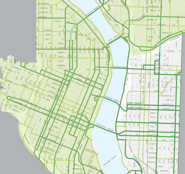
Some recent updates to a map of future bikeways in Portland’s central city have advocates talking.
The map of “city bikeways” and “major city bikeways” (the difference between the two is that on “major city bikeways,” biking is relatively more important compared to other modes) is the latest sign of which streets will be candidates for protected bike lanes in the $8.4 million Central City Multimodal Safety Project that’s supposed to begin public outreach this summer.
The central city bikeway map has been refined since we covered an earlier version of it in February, but it’s not yet finished. The current draft is the one being “proposed” by city staff, before approval by the Planning and Sustainability Commission or the City Council.
Feedback to the planning commission is due Aug. 9.
Among the notable details here:
• SW Alder Street, a useful connection between Northwest Portland and the Morrison Bridge, will be upgraded to a major city bikeway across Interstate 405, but only as far east as Broadway. Between Broadway and the river it would no longer be a designated bikeway.
• SW Washington Street would be upgraded to a major city bikeway between Broadway and I-405, so Alder/Washington would echo the existing Oak/Stark couplet closer to the river.
• SW Yamhill, where the westbound MAX tracks run, is no longer marked as a potential bikeway. Neither is Morrison, one block to its north, where the eastbound MAX tracks run. But Taylor, just south of Yamill, is now seen as a future bikeway. So is Salmon, the one-way eastbound street one block south of Taylor.
• As previously proposed, SW Jefferson and Columbia streets would become a major city bikeway couplet between SW 19th and Naito Parkway, making them major connections across Interstate 405 and almost to the Hawthorne Bridge.
• SW Harrison Street would be upgraded to major city bikeway as far west as the Park Blocks, creating a link between the South Waterfront (including Tilikum Crossing) and Portland State University.
• The city continues to pull back from the idea of Fourth Avenue, with its many garages, as a major northbound bike route through downtown. It’s no longer marked as a major city bikeway north of Madison.
• SW Second and Third avenues, both of which are getting bike lanes in the Old Town area already, are now a major city bikeway couplet between SW Market and NW Flanders. This sets up two future routes to bike north or east from the PSU area: the Park Blocks to the Broadway Bridge or Columbia/Second to the Morrison, Burnside and Steel bridges.
• East of the river, SE 11th and 12th Avenues have been upgraded to major city bikeways (a change that was “literally applauded” when city staffers mentioned it to the Bicycle Advisory Committee on Tuesday, according to Jessica Engelman of BikeLoudPDX). And the city now envisions a direct north-south biking-walking bridge across Interstate 84 at 7th Avenue rather than cutting the angle to 8th and then jogging back to 7th.
Advertisement

ODOT approves “multimodal mixed-use area,” giving downtown permission to evolve away from cars
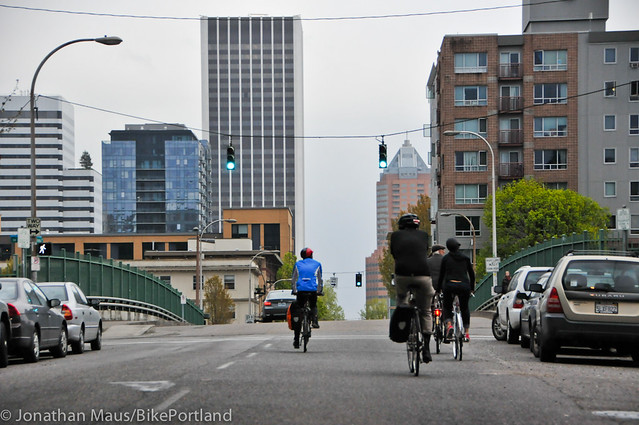
(Photo: J.Maus/BikePortland)
This is essentially a way of locking in the idea that as new buildings arrive in the area, the city will simply let nearby auto congestion increase.
Another significant change for the central city, embedded in the proposed Central City 2035 plan, is the fact that downtown is becoming the first “multimodal mixed-use area” in the city of Portland. This is essentially a way of locking in the idea that as new buildings arrive in the area, the city will simply let nearby auto congestion increase.
In many other cities, developers are required to pay to increase the automotive capacity of nearby intersections, an expensive requirement that effectively shuts down new development in denser areas. In central Portland, this will only be necessary if the additional congestion causes a safety problem — for example, traffic won’t be allowed to back up all the way onto a freeway offramp.
Because the Oregon Department of Transportation controls several freeway intersections in the area, it had to sign off on the city’s proposal. It did.
“The concept is that if you have downtown and you have other modes — bike as well as ped as well as transit — and you have a mix of land uses that makes it possible to get around by those modes — that’s good, that’s something the State of Oregon supports,” said Lidwien Rahman, a principal planner for ODOT’s Portland regional office. “So you shouldn’t have to worry about vehicle mobility because you can get around at those other modes.”
Rahman said ODOT’s only condition for signing off was that the city vet this plan with interest groups such as its freight committee and the Portland Business Alliance, which it has.
“As long as everybody knows that this is the choice you’re making, it’s all good,” Rahman said.
In a somewhat related change, most of the central city will also be designated as a “bicycle district.” This is another concept from the city’s Bike Plan for 2030, defined as an area “with a dense concentration of commercial, cultural, institutional and/or recreational destinations
where the City intends to make bicycle travel more attractive than driving.”
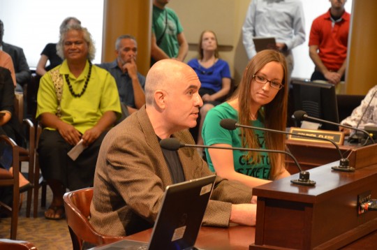
Analysis from BikeLoud’s Engelman
(Photo: M.Andersen/BikePortland)
City transportation planners Mauricio LeClerc and Zef Wagner visited the Portland Bicycle Advisory Committee Tuesday to discuss the changes.
Engelman, who is a co-chair of advocacy group BikeLoudPDX, was one of those who attended. Below are passages from her report about the meeting.
On the “bicycle district” designation:
Does this mean putting sharrows and “bikes may use full lane” signs on every street? Re-time the lights to be at more of a bicycle pace? Minimum bicycle parking requirements? etc. These are the types of specifics that need to be determined for “bicycle district” to actually mean anything.
On reaction from the advisory committee:
A few BAC members had comments regarding specific streets: one thought was that SW 4th would be a better major city bikeway than SW 2nd because it could serve as a couplet with Broadway. There was also a call to attention regarding the lack of bike connections on the west side of the Morrison Bridge (considered an important issue because the Hawthorne Bridge is already over capacity during rush hour). There was support from a few members for a city bikeway designation on NE Davis east of 7th. And the room literally applauded the major city bikeway designation on SE 11th and 12th (something BikeLoudPDX strongly recommended in our testimony).
On the Central City Multimodal Safety Project:
The multimodal project is for ALL of Central City, not just downtown, although there is an expectation that most of the funds will go there, but with public support, a project or two from Lloyd or Central Eastside may also be able to draw from that pot of money.
And on the effectiveness of BikeLoud’s testimony so far:
Fortunately they incorporated so much of what BikeLoudPDX requested last time that there’s not as much to testify on this time around, except to again highlight which specific projects we think should be a priority, re-recommend the few things we didn’t get in this draft, and maybe comment on a few streets’ MCB vs CB classifications.
Correction 1:40 pm: An earlier version of this post confused Yamhill, Taylor and Morrison at one point, and gave the wrong name for a “multimodal mixed-use area.”
— Michael Andersen, (503) 333-7824 – michael@bikeportland.org
Our work is supported by subscribers. Please become one today.


Thanks for reading.
BikePortland has served this community with independent community journalism since 2005. We rely on subscriptions from readers like you to survive. Your financial support is vital in keeping this valuable resource alive and well.
Please subscribe today to strengthen and expand our work.
That’s a lot to digest, but my hot take is: wow. Brilliant. Now show me a budget.
What would the city be willing to do on Harrison? Between 1st and 4th you have the streetcar and several buses slowed to a crawl during rush hour already. Rip out all the trees and the planter strip to make room for a bike lane? Are they going to get rid of a general traffic lane there? Try to make it a local access street for the apartments and garages and push through autos elsewhere?
Lines on a map are nice. Detailed street plans a bit better. But there isn’t much to celebrate until there’s something on the ground. Montgomery used to have a nice line on the map. It isn’t there anymore.
PBOT staff has made it known that they intend Alder between 19th and 13th (?) to be a two-way bike route in the future, even though the one-way option was the preferred alternative in the Burnside/19th/18th project.
Another major addition is making NW/SW 16th a continuous bikeway in complement to NW/SW 14th going northbound.
There was also considerable discussion regarding SW 18th in Goose Hollow. Notice that that is no longer being considered a City Bikeway. PBOT’s alternatives are either taking SW 20th along steep grades in Kings Hill, or a future connection through the Lincoln HS campus.
Another change includes making NW 9th a Major City Bikeway, this would be a great way to distribute bike traffic between the east-west bike corridors in NW (Naito, Overton, Marshall, Lovejoy, Johnson, Flanders). But it means that PBOT would need to remove street parking on both sides of the street.
Maybe consider a two way path on the east side along the post office. It would be a short route and the super block cuts down on the number of intersections.
That only gets you from Hoyt to Lovejoy. And then what?
I’m very interested in what folks think of the Goose Hollow parts of this plan. I’m concerned that the grades on SW 20th (and the Salmon approach to 20th) and Columbia are so steep as to discourage many folks from using these.
What do people think?
Chris, I think I’ll continue to take my chances on 18th. Maybe PBOT should consider cutting into the sidewalk so that we can get real bike lanes on that street.
There isn’t a lot of walking room (at least not continuously.) Cutting into the sidewalk means ripping out trees, street lights, streetcar poles, bike parking etc…
Yep, it won’t cheap. We could always remove the on-street parking as well.
On street parking isn’t continuous either.
Not much parking to remove…
That would violate the Transportation Strategy for People Movement, which says that bicycle projects should not make things worse for pedestrians. There’s really no way to fit bike lanes on 18th when the cross section is: Sidewalk – Lane – Rail – Rail – Lane – Sidewalk. No parking to remove, no travel lanes to remove. I can’t see how it would work. It can’t be bike only, because it carries bus service and is critical for traffic and emergency response (especially on game days).
I used to live up the hill on 20th and would never ride up it. I used the elevator in the Mac parking garage instead. If the bikeway is put on 20th, I guarantee no one will use it – it’s way too steep to go up then down two blocks later, when 18th is nearly flat. This decision fits with PBOT’s pattern of putting greenways on the steepest routes while drivers get the flatter roads. People will use 18th anyway, why not encourage the behavior that’s going to happen anyway by making it safer to do so?
PBOT has pre-project bike data for NW/SW 20th, Raleigh to Jefferson.
132 per day were counted north of Quimby
186 per day were counted south of Kearney
245 a day were counted south of Everett
86 cyclist a day were counted south of Yamhill
237 per day were counted south of Madison
What about 18th? I rode it a lot a few years ago, horrible MAX crossing be darned.
Absolutely. SW 18th was preferred mostly for that reason. I’d say the grade on SW 20th will render it ineffective.
There is no way folks will take 20th, it’s fairly steep. Instead, they will continue to use the less than stellar, but far easier, option of 18th.
5th Ave needs to be free of private cars.
And 6th.
I think this is a good start. However, it’s not simply good enough to say “we’re going to stop increasing auto capacity”. We need to be reducing auto capacity and demand. One way is to convert a land of motor traffic into a protected bike lane. I’m fairly confident that charging $20/hour to park anywhere downtown will encourage most people to take transit or bike. Another option is congestion charging.
Overall, I think this bike map looks good, as long as all those dark green lines are separated cycleways and not just wide painted bike lanes that allow people to drive in them (hello, Third Av!). When I hear the word “bikeway”, I don’t think of sharrows or even the right-hook lanes on Oak/Stark.
I tend to agree, but with such crappy infrastructure and substantial gaps in bike infrastructure that people use to GET to downtown, I’m not sure that this plan is going to do much beyond improving conditions for folks who already ride downtown. If you want to reduce reliance on cars, you have to give people viable alternatives to get from where they live to where they work. Increasingly, that means getting people in from further east, as well as SW, Beaverton, Tigard, and Milwaukee.
Rail is better for getting people from the suburbs into the city center, and once they’re here, they can hop on a bike share bike for the last mile. Biketown plus upgrading center city infra should make a big difference.
I’m not so sure about that. Personally, I find multi-modal transport to be a hassle. One of the things I like about getting around by bike is not having to worry about train or bus schedules, and I doubt I’m alone in that sentiment. I’d much rather ride the whole 10 miles from my house to downtown than take a train and ride 1 or 2 miles, a distance I’m much more inclined to walk. When I talk to my friends and neighbors who live farther out and ride bikes, most seem to share my concerns.
Depends on the distance and terrain, honestly. I can see bike commuting from Milwaukie (though I’d still personally take the train) but Beaverton or Tigard require riding over the West Hills, and I’m not sure many people would want to make that journey daily. Bike share makes that multi-modal transport much easier because it removes the hassle of bringing your bike on MAX or bus and you don’t have to worry about not getting a space. People typically do what’s most convenient for them and bike share makes riding incredibly convenient.
On the picture, I’m seeing something that looks like a viaduct over I-5 between NE Clackamas and N Vancouver / Williams. Is there any more info about that project?
Also, looking at the transit and bike maps in the PDF, when it says “major” bike or transit street, does that mean that we will finally get bus lanes on these streets or protected bike lanes or cycle tracks on these streets?
A Clackamas overcrossing was part of the i5 rose quarter expansion plans.
http://bikeportland.org/2012/06/07/time-is-now-to-engage-on-i-5-expansion-plans-near-rose-quarter-72846
“SW Yamhill, where the westbound MAX tracks run, is no longer marked as a potential bikeway. Neither is Morrison, one block to its north. But Taylor, where the eastbound MAX tracks run, is now seen as a future bikeway. So is Salmon, the one-way eastbound street one block south of Yamhill”
You’ll want to check the maps again on this one…
Great article though.
Thanks, fixed.
Thanks! One more thing though, not that it really matters much, but Yamhill is eastbound and Morrison is westbound.
The designation of 11th and 12th as major city bikeways is a major win. It’s also great to see Jessica’s phenomenal advocacy on the Central City Plan being covered.
*******************
On to some criticisms:
Another oversight was the lack of Major City Bikeway designation for Burnside and Couch south of 6th. The Burnside bike lane is a *major* bike route and gets far more bike traffic than Ankeny in this area. Moreover, if we are serious about a 25% cycling mode share goal we need to allocate space for bikes on the most efficient routes to river crossings.
I agree with the BAC member that SW 4th should be designated a major city bikeway. It has 3-4 lanes of traffic (and parking in some sections) which affords significant space for a world-class bike facility. Moreover, due to its central location it will better serve PSU, the downtown area, the pearl district, and old town than routes on the periphery (e.g. 2nd). SW 4th also has better connections to the Hawthorne bridge than SW 2nd.
How is SW4th to Madison better than SW 2nd to madison? Main to 2nd doesn’t have the hill with the swerve around the fountain that main to 4th does.
Now that right turns are banned, the bike lane on Madison works reasonably well. You do raise a good point about the fountain on Main but I honestly never use 2nd to go anywhere because it does not connect well to the places I’m interested in traveling.
Well for one, there is no signal at SW 2nd and Clay.
https://www.portlandoregon.gov/transportation/article/534000
There are plans to install a signal there.
Perhaps we could have 3rd/4th from Jefferson/Columbia to Stark/Oak, the 2nd/3rd north of Stark/Oak? That seems like a good compromise. It provides a more direct route from PSU to the north, but also respects the the upcoming 2nd Ave project in Old Town. Plus 4th is not great for crossing Burnside since it crosses the Chinatown Gate which is a pinch point.
11th and 12th are a long time coming. I imagine better engineering than the Williams/Vancouver couplet. Please let this be in the 1-2 year works.
What was missing in N Portland was 1) dedicated lanes for bikes only and 2) consistent physical separation. This could have been achieved by simply altering the direction of traffic in key places, e.g. having Beech one way Eastbound thereby eliminating the need for a left turn lane on Williams.
In a Major City Bikeway, “bicycle transportation will have priority over motorized travel.” As an example they show the East Side Esplanade. Can we assume that this means physically separated lanes?
As noted above Harrison is designated as such, but it seems doubtful the city will remove a lane of car traffic in each direction. What are the consequences if these are not completed by 2035? What is the timeline for this to be implemented?
Major city bikeway description from the draft TSP:
Major City Bikeways form the backbone of the city’s bikeway network and are intended to serve high volumes of bicycle traffic and provide direct, seamless, efficient travel across and between transportation districts.
Land Use. Major City Bikeways should support 2040 land use types.
Improvements. Major City Bikeways should be designed to accommodate large volumes of bicyclists, to maximize their comfort and to minimize delays by emphasizing the movement of bicycles. Build the highest quality bikeway facilities. Motor vehicle lanes and on-street parking may be removed on Major City Bikeways to provide needed width for separated-in-roadway facilities where compatible with adjacent land uses and only after performing careful analysis to determine potential impacts to the essential movement of all modes. Where improvements to the bicycling environment are needed but the ability to reallocate road space is limited, consider alternative approaches that include property acquisition, parallel routes and/or less desirable facilities. On Major City Bikeways developed as shared roadways, use all appropriate tools to achieve recommended performance guidelines. Where conditions warrant and where practical, Major City Bikeways should have separated facilities for bicycles and pedestrians.
>As an example they show the East Side Esplanade. Can we assume that this means physically separated lanes?
I’d say conditions would warrant separate pedestrian and bicycle facilities there. If they didn’t, I don’t think OMSI would have gotten the fast bikes use water signs. But ‘where practical…’
‘Careful analysis to determine potential impacts to the essential movement of all modes’ sounds like no, you should not assume major city bikeway designation on a road means a physically separate path on that road.
“after performing careful analysis to determine potential impacts to the essential movement of all modes” = if it slows down cars, we won’t do it.
Sort of. I think the language was put in after a push by freight interests who didn’t want their trucks stuck in car traffic.
“In a somewhat related change, most of the central city will also be designated as a ‘bicycle district.’ (…) where the City intends to make bicycle travel more attractive than driving.’ ”
I wonder how the city intends to achieve that. Riding on Broadway’s “bike lane” today I would not consider that an infrastructure that makes bicycle travel more attractive than driving. To achieve that, I think the bike lane would need to be converted to a separated cycleway, which would probably require removing one of the three (!three lanes! In a downtown!) car lanes or the parking lane. It would be good to know how the city intends to operationalize this concept.
On a different note: making downtown a multimodal mixed-use area and thereby allow congestion to increase is a way to save money relative to the status before that, which would require further infrastructure construction. This money that the city or state would otherwise have to spend could / should go to other infrastructure development.
Any specifics for what is envisioned for SW Park? Will parking be removed? Will cars be banned? So much potential here!
This really needs a detailed design process with several alternatives explored. There are really so many opportunities to rethink that space.
What do the green dotted circle lines mean? I see a number of them in inner NW on the map.
You have one through the high school campus aligned with 16th. A couple through the post office superblock. Potential future NE 7th bridge over 84. Potential future NE Clackamas bridge over i5. And a few connecting Naito and the riverfront trail to Pearl/NW aligned with Irving, Marshall, and Pettygrove. They’re all potential future bike/ped projects where you don’t have a motor vehicle road to take space from today, so you have to build something new.
Am I seeing a Sullivan’s Gulch path between Lloyd Blvd and I-84?
Yes.
I’m just hoping there will be some improvements to SW Main. Right now the Hawthorne Bridge (the busiest bridge in town, I’ve heard) just dumps cyclists out onto a narrow, two lane, uphill street that’s usually chock full of backed up car traffic every morning. I filter through because I don’t want to sit and suck in car exhaust for an extra five minutes, but that’s dangerous, too. Why isn’t there any facility for cyclists?