
After months of hearings with the Portland Design Commission — and almost 15 years of planning in total — the vision for a new district surrounding the Oregon Museum of Science and Industry (OMSI) in Portland’s Central Eastside is now one step closer to fruition. Last week, the Design Commission voted to approve the most recent iteration of the OMSI District Master Plan: a “one-of-a-kind neighborhood that is an inclusive community destination with innovation, culture, arts, and science learning at its heart.”
The OMSI District will consist of new construction in the 10-block, 34-acre area surrounding the museum, with the potential for hotels, restaurants, retail spaces, offices and thousands of new housing units on land currently used as surface parking lots. The plan also calls for a realignment of Water Avenue that would split the street into “Old” and “New” Water Aves. Old Water Ave is designated for local traffic in the district, while New Water Ave would function as a throughway and contain a new two-way cycle track linking to the Hawthorne Bridge on the north and the Tilikum Crossing and Springwater Corridor Trail to the south. The plans for Old Water Ave also contain a two-way cycle track on most of the street, which is designed to “facilitate movement of…local visitors from exterior routes…to interior destinations, such as OMSI or the waterfront.”
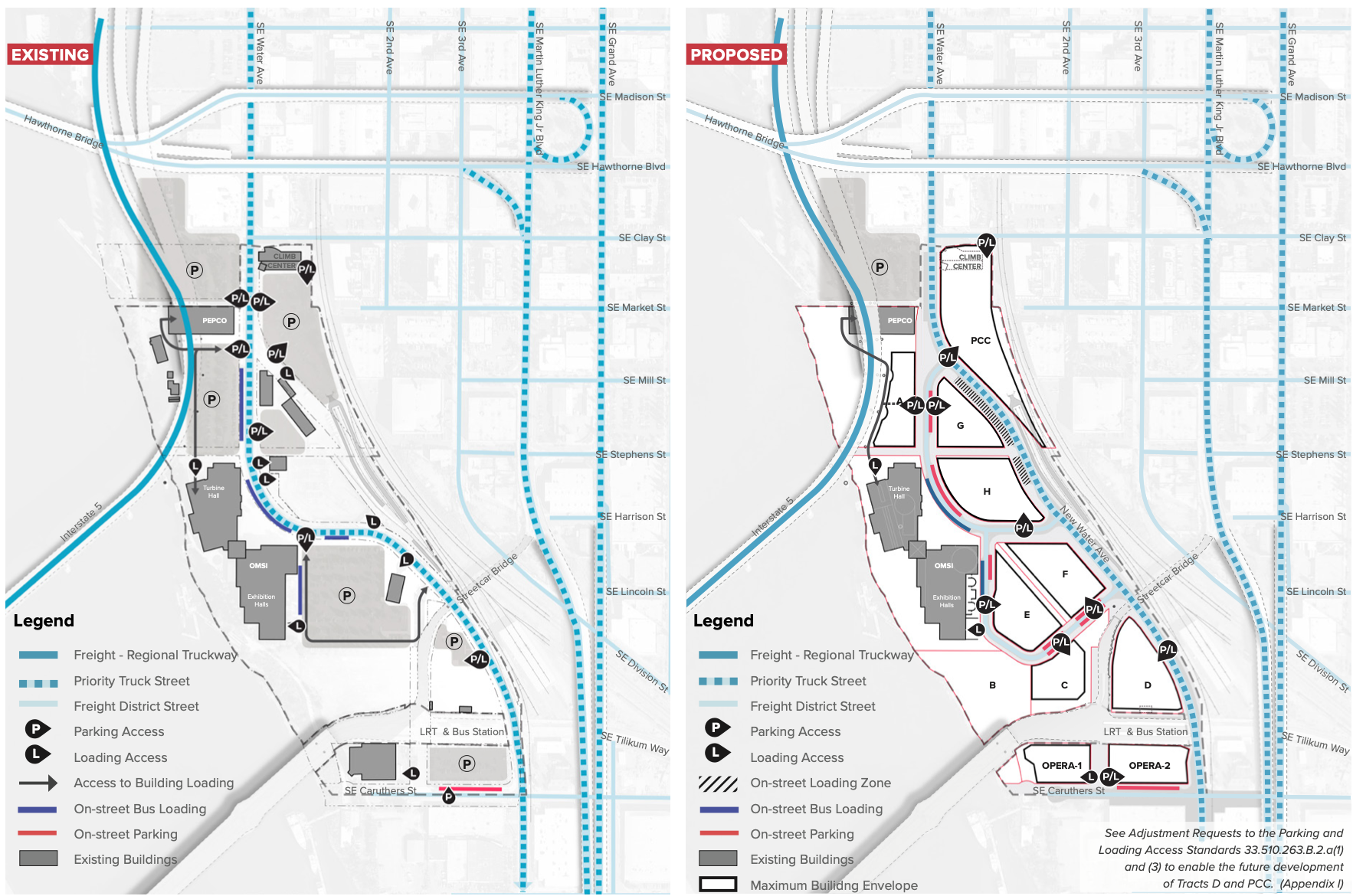
There will also be new signalized crossing opportunities at SE Caruthers Street and Water Avenue as well as at the I-5 exit for Water Ave to “enhance the quality and safety of the frequent pedestrian and bicyclist crossings that occur.”
Additionally, the plan calls for a significant investment in open public space — 20% of the OMSI District must be devoted to “parks, outdoor recreation amenities, plazas, public fountains, or landscaped areas,” per the Central City Master Plan. The plan explains that this open space will be split into three sections: south, central, and north, all making up a waterfront education park “opening up access to the Willamette River and grounded in indigenous ecological knowledge.”
In a staff report from August, Portland Bureau of Transportation engineers expressed skepticism about some of the proposed street design elements, including lane widths for car and bike traffic and how people on bikes would enter the new district north and south of the site. But after more thorough review — and a few requests for changes to the plan — PBOT approved the plan’s most recent iteration, saying they “find that adequate and timely transportation infrastructure will be provided in the master plan area.”
The requested changes don’t include any major differences to the cycle tracks or overall street layout, however: the layout remains very similar to its initial design proposal all the way back in 2017.
One of the main PBOT approval criteria was that the “development of public transportation infrastructure [will] occur no later than the development of specific tracts within the master plan area” to make sure active transportation infrastructure will be available during the development and construction process of the entire district. Either the New Water Ave bikeway or 2nd Ave to Caruthers will be available as a Major City Bikeway from the Tilikum Crossing.
“PBOT recommends conditions of approval for a phasing plan for transportation infrastructure that does not rely on multiple zones and will be simpler and clearer for future reviewers to determine when public street improvements will be required,” a PBOT memo in the latest staff report states.
PBOT’s conditions for approval also include funding negotiations to help with street and signal changes.
Right now, OMSI has committed $33 million in funding for the project, with a private sector commitment of $44 million. OMSI is requesting $38 million from the City of Portland, which the city has not fully agreed to. Funding negotiations will be worked out separately, but will certainly play a major role in whether or not the plan comes to fruition to its full extent.
But for now, the Design Commission approval marks a step in the right direction for project boosters. The plan will certainly something to keep an eye on as it unfolds.


Thanks for reading.
BikePortland has served this community with independent community journalism since 2005. We rely on subscriptions from readers like you to survive. Your financial support is vital in keeping this valuable resource alive and well.
Please subscribe today to strengthen and expand our work.
There is a lot to like about this plan. IT has a lot promising public openspaces and what looks like promising mix of land uses. I am disappointed that they are sticking with the 2-way cycletrack along “New Water”. This street is also the local truck route, and there is a lot of truck traffic through here. The most sensible location for the cycletrack is the east side of the street, parallel to the RR tracks to avoid right hooks. The trade off is the connection at the north/south ends and the fat that cyclists are cut off from all the new destinations in the OMSI District. I get what they are trying to do: make a fast efficient route for freight which is very important to the CEID, and keep bikes out of the way. I wish PBOT would stand up to the freight interests and say no to this by-pass freight route and create a complete street that bikes and trucks can safely share. That would look like buffered bike lanes on each side of the street, and a road that goes through (not around) the development.
You think buffered bike lanes is more of a “complete street” than a two-way protected bike lane? That doesn’t make any sense to me.
Part of the the complete street comment is that the proposed route is by-pass road that only connects to the businesses and residences on one side of the street. This is high-speed and no friendly by design. A cyclepath could be buffered from this and be safe and efficient, but it will have tradeoffs- there will either be awkward/unsafe connections at either end when it transitions to bikes on either side of the road and the bikes have limited connections to anything in the new district, or the bike path is along the development and there are multiple dangerous spots where half the bikes are coming from the “wrong” way, and the other half are in danger of right hooks. Changing the development pattern to get rid of the bypass route would include bike lanes are integrated into the street and the development. There are still right hook dangers, but the bike connections on either side of the district are seamless. These bike lanes are fully integrated in the street and the neighborhood meaning people biking, walking or driving can enter/exit at every block. This is what I mean by designing this as a complete street: a street that supports multiple forms of transportation, and street life- shopping, dinning, dog walking, etc. The biggest trade-off for this types of street is that freight/businesses would lose a quick bypass in and out of the CEID.
I agree. The design expects southbound bicyclists to cross Water Avenue twice within a short distance to enter/exit the two-way bicycle track. I would not use it when heading southbound because I consider that less safe than staying in the main traffic lane.
It will be a great improvement, but 1,200 units of housing is underwhelming right next to a transit hub and so close to so many things.
Very exciting! Hopefully this will get some city staff hungry to have more eastern waterfront development. Let’s sneak in removing i5 south of i84 😉
Now if only we could do something about the noise and traffic from I-5….
It’s my understanding that the “access to the river” is only going to be visual and educational/interpretive. Surrounding neighborhoods, as well as some of the tribal interests wanted, at a minimum, a carry-down canoe/kayak launch (similar to what is in south waterfront behind Mirabella). There was also great interest in creating a recreational access site for multi-tribe canoe events like the Tribal Journeys program, or other in-river cultural activities. Not gonna happen.
Housing units are better than parking lots. I’m curious how the land deals are going to be structured. Hopefully they are 50-99 year land leases so that OMSI will eventually get something back. (This has recently been a major boost to UW in Seattle when they got back several blocks of prime downtown real estate with the expiration of a 99 year land lease).
Hopefully OMSI isn’t just selling off their prime location for short term gain.