— This story is by Jacob Loeb. It was first published by Montavilla News on October 10th.
Over the last two years, staff at Portland’s Bureau of Planning and Sustainability (BPS) developed a plan to cultivate two new commercial centers for residents living south of SE Foster Road in the Brentwood-Darlington neighborhood. Out of that work and years of gathering community input, BPS drafted the Lower SE Rising (LSER) Area Plan to create community cores similar to what other Portland neighborhoods inherited. Through proposed zoning changes and transportation investments, the plan’s authors intend to incentivize future development that will create new walkable corridors lined with small businesses and multifamily housing.
On Tuesday, the draft plan appeared before the Portland Planning Commission, a key step toward eventual adoption by Portland City Council.
Many of Portland’s neighborhoods feature commercial corridors with stores and restaurants clustered around main streets. As with Montavilla’s SE Stark Street and NE Glisan Street, most commercial districts centered on transportation hubs created by historic streetcar lines or major roads. Often, businesses coalesced in these spaces over 100 years ago. However, not all communities in the city had that historic commercial core before the automobile age shifted resources miles away from where people lived. City planners are now working to reduce reliance on personal vehicle travel and strengthen locale retail access within neighborhoods, creating environments where residents can walk or take transit to desirable destinations. In older areas, that takes less effort because a legacy organization of buildings already supports that effort. However, in some communities with predominantly post-war development, community intervention is needed to create the desired change.
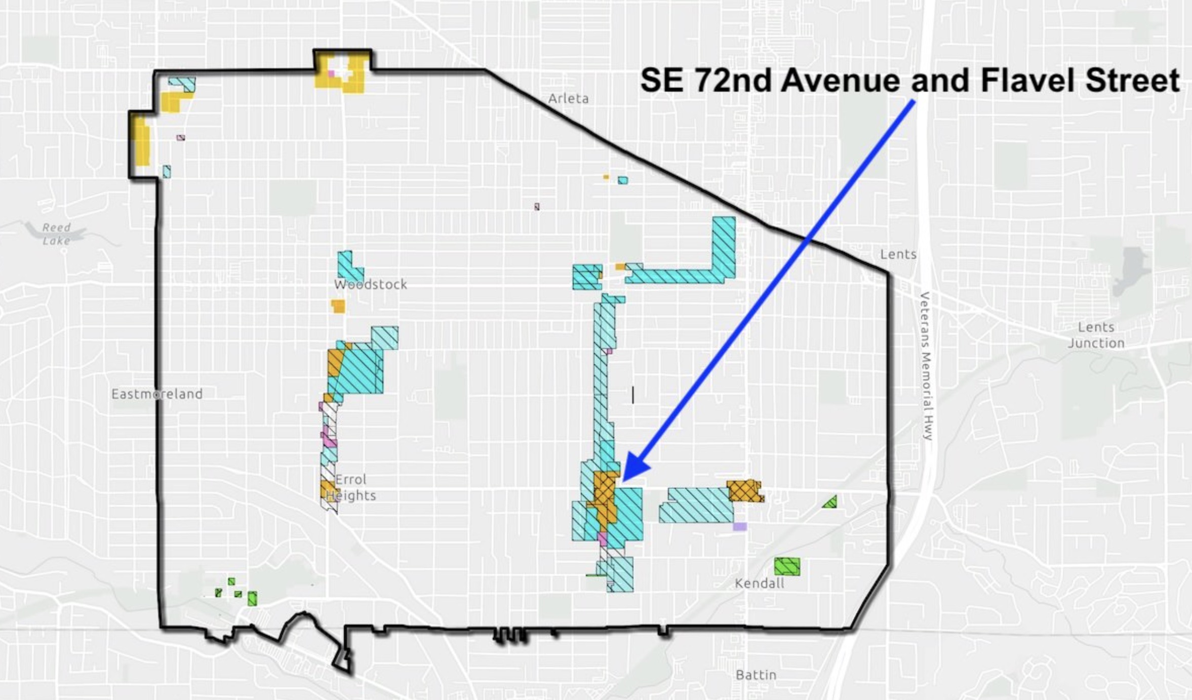
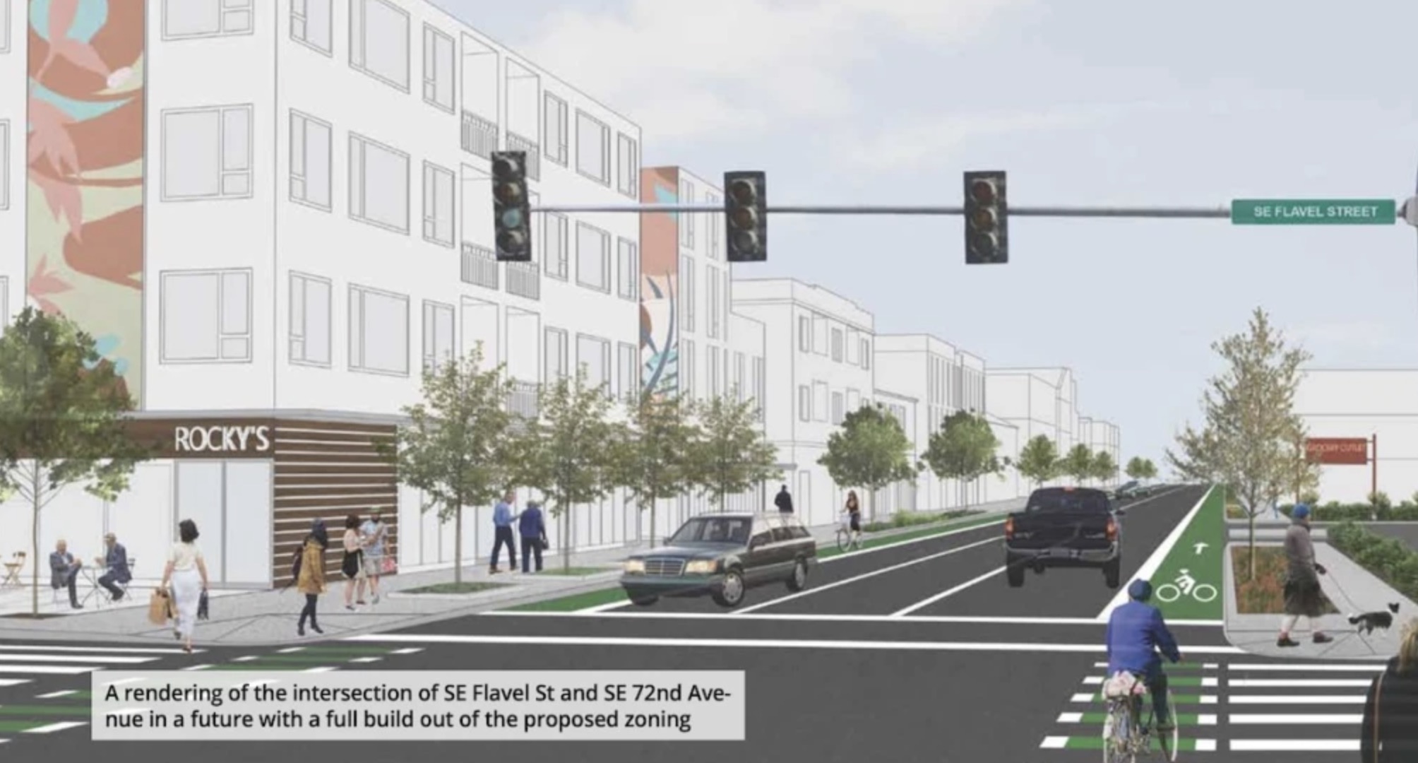
The draft Lower SE Rising (LSER) Area Plan proposes turning SE 52nd and SE 72nd Avenues into mixed-use corridors with more housing options and commercial hubs at primary intersections in the Brentwood-Darlington neighborhood. The new commercial district on SE 72nd Avenue and Flavel Street extends towards SE 82nd Avenue, creating a more significant business district that links to a major arterial road. If the City Council approves the plan, zoning changes will be the first step towards instigating uses along the corridor. However, those changes only allow new commercial services and do not force property owners to make any changes unless completely redeveloping a site. Further enhancements are needed to draw people into these centers, spurring property transformation. As in the past formation of community hubs, transportation can attract people to a business district.
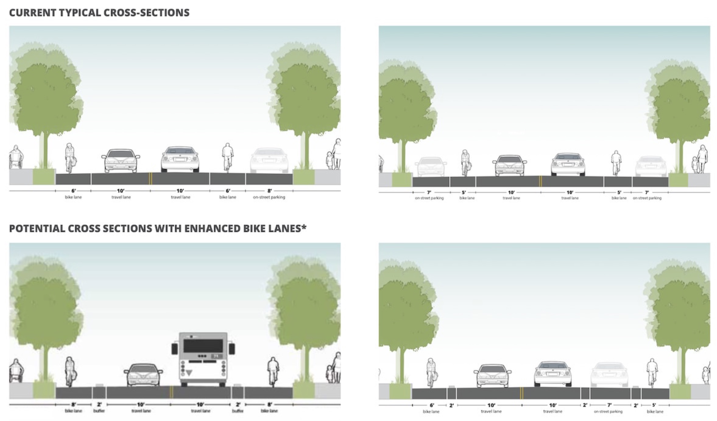
The plan’s authors propose street improvements, making it safer and more accessible for pedestrians to navigate and cross the busier roadways like SE 52nd, SE 72nd, and SE Woodstock. Additionally, the plan includes neighborhood greenway projects connecting the bicycle and pedestrian networks through this area. However, enhanced bus transit in this district offers a high likelihood for increased housing density and business growth while strengthening other centers. “One thing we’re finding is that the existing transit network didn’t really serve centers. For example, you cannot take a bus from the Woodstock neighborhood center to the Lents Town Center,” explained Bill Cunningham, a City Planner with BPS. Realigning bus routes and creating more frequent service between centers can provide the linkage needed for these fledgling business districts to take root. The LSER plan will integrate with future transit line adjustments underway as part of TriMet’s Forward Together plan to cultivate the desired change.
The Lower SE Rising (LSER) Area Plan is a response to community desires. It offers a chance to create a walkable and community-focused neighborhood similar to what Montavilla residents enjoy. The 172-page draft plan is available for public review. People can also use the Map App to leave written testimony and review what other people have contributed.
Planning Commission members voiced positive comments about the plan at their meeting yesterday, and will now deliberate for several weeks, as they take a closer look at the plan through November before forwarding their recommendations to the Portland City Council. The community will have other opportunities to provide comments during the City Council’s review sometime in spring 2024. If approved, substantial growth for the new could take decades of slow transformation. However, that slow change should help prevent sudden displacement while creating opportunities for micro businesses to sprout up in formerly residential buildings.


Thanks for reading.
BikePortland has served this community with independent community journalism since 2005. We rely on subscriptions from readers like you to survive. Your financial support is vital in keeping this valuable resource alive and well.
Please subscribe today to strengthen and expand our work.
Yes! A huge chunk of my riding is up 52nd from Milwaukie and while I’m a confident rider. Let’s just say it is not my favorite place to be, especially during ‘bike lane full of gravel’ season. Of course this only goes to Woodstock so not my whole ride, but still a significant section! Not to mention the benefit to people who actually live in that area, not just riding through like me!
Why, in this day and age, are they showing anything other than protected bicycle lanes as a marquee image? The proposed cross-sections look good, but why show green bike lanes as the one image people will take away with them?
That is sad. The cross-sections at least show a low concrete curb between the bike and vehicle lanes.
Also, the rendering arbitrarily shows the correct bar crosswalks going one direction, but the old striped one going the other. And it shows the horrible diagonal curb ramps. As drawn, it’s literally impossible for someone needing a curb ramp to cross the street (72nd) without leaving the crosswalk. The woman in the tan coat should have a “WTF” cartoon thought bubble.
I realize it’s “just a rendering” but those are all really basic mistakes. At least the dog’s on a leash, though. And I guess for balance, they didn’t do that well with the traffic lights (set up for two vehicle lanes instead of one) either.
This is a terrible plan that will make one of Portlands last affordable and most diverse neighborhoods (per the planners at the Lower SE Rising hearing Oct 10th) into one packed with brand new apartments. Those with the rents that come with brand new apartments. Did they mention that none of these will have parking? Developer don’t need to install parking once the rezoning takes place. A brand new overpriced neighborhood packed with cars in every street is a thieves paradise.
You bring up such a good point!! We should make it law that nothing new can ever get built unless it’s a parking lot. Let’s also have a cop on every corner to shoot anyone who look like they might be a thief.
I brought this up on the map feedback but I lead one of the Woodstock bike buses and this plan still doesn’t include a safe route to school for us. I’ll still be physically blocking traffic with my body in ten years if and when this all gets done.
That is my neighborhood! I am so glad we are getting so much needed attention.