The Oregon Department of Transportation brushed aside proposals to allow safe bike travel on Southwest Barbur Boulevard, raising the possibility of “unacceptable impacts” that might result from replacing a northbound travel lane with dedicated bike lanes.
“While some have framed the removal of a motor vehicle lane on the bridges as a quick and easy, ‘noimpact’ solution, there are impacts that need to be considered,” the agency wrote in a memo distributed Thursday evening.
The memo cited estimates that removing one of Barbur’s four travel lanes would increase northbound auto travel times between 5 and 15 percent today, and somewhere between 10 and 65 percent by 2035.
During the busiest few minutes of the morning on the 4.9 mile corridor in question, it comes out to an additional delay of somewhere between 84 seconds and 9 minutes over the course of the next 22 years.
Update 8:03 pm: I’ve changed these figures (previously 1.8 miles and 36 seconds to 4 minutes) to include the full stretch of road studied and to allow an apples-to-apples comparison of travel times in 2035. -MA
“The actual amount of delay would likely fall somewhere in between these two predictions on ‘typical’ travel days,” the memo from ODOT’s Jessica Horning explained.
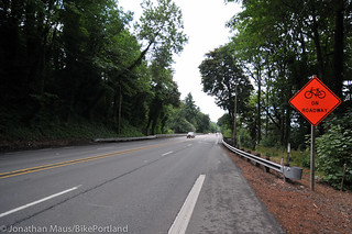
Barbur currently forces cars and bikes to merge into the same lane as they cross two narrow bridges on Barbur. The speed limit on the bridges is 45 mph.
“Over the past several months, ODOT has received both strong messages of support for a road diet,” Horning wrote, “and strong objections from stakeholders who feel that reducing motor vehicle capacity on Barbur/99W would create unacceptable impacts for commuters, businesses, transit, and freight operations.”
ODOT spokesman Don Hamilton said Tuesday that he didn’t know if ODOT’s traffic models accounted for any reduced auto traffic that might result from turning Barbur into the only safe and comfortable bikeway between Southwest Portland’s 60,000 residents and the rest of the city.
“That’s a good question,” Hamilton said. “I’m not sure.”
Update 6:34 pm: According to files provided by Hamilton, the traffic model used by ODOT that found the 65 percent increase assumes that the ratio of people driving, biking and taking transit would be unchanged both by bike improvements and by increased congestion, and that people would not readjust their schedules to avoid congestion.
Two weeks ago, ODOT wrote in a press release that “traffic will not be significantly impacted” by the temporary removal of two motor vehicle lanes on the bridges, “especially over time as motorists adapt to the changes.”
The memo released Thursday night also estimated that “a significant amount of traffic (5-20% of vehicles today, and 10-35% in 2035)” would “divert to local streets such as Corbett, Terwilliger, Capitol Hill, and Taylor’s Ferry.” It did not discuss the possibility of other measures, such as speed bumps or traffic diverters, that might limit such diversion.
Hamilton said such measures were outside the scope of ODOT’s study.
“This was designed to understand what a road diet would affect,” Hamilton said.
He added that “any suggestion that we ignore bike and pedestrian needs is incorrect.” ODOT is planning to install a flashing “bikes on bridge” sign and to reconsider bike improvements as part of the Southwest Corridor planning process that’s expected to wrap up in the mid-2020s at the soonest, though changes to bike facilities might happen earlier in that process.
“This is an area that is ripe for improvement, and it’s getting some serious attention,” Hamilton said.
Horning, who works a 4/10 schedule, was unavailable for comment Friday.


Thanks for reading.
BikePortland has served this community with independent community journalism since 2005. We rely on subscriptions from readers like you to survive. Your financial support is vital in keeping this valuable resource alive and well.
Please subscribe today to strengthen and expand our work.
Sounds like sumwun’s talkin’ out bot sides of their neck…
…the top side and the bottom side?
Did they average in the multi-hour delays that serious injury or fatality collisions will cause, and how much more likely those are in the present configuration?
(and in general: boooo-hissss)
Anybody know who to contact at ODOT to express our opinion on this issue?
jessica.horning@odot.state.or.us sent the statement to stakeholders.
Sweet thanks! Also sent email to the ODOT Director’s “Office” at askodot@odot.state.or.us
Thanks for the email addresses. It took me three minutes to send an email.
Toward the middle of the ladder, I might also recommend ODOT Region 1 Policy and Development Manager Rian.M.Windsheimer@odot.state.or.us (Horning’s boss) and Region 1 Manager Jason.A.Tell@odot.state.or.us as other influential people on decisions like this one.
Thanks!! Sent to them too!
Isn’t there an elected leader that oversees ODOT, like the Governor? I don’t know who it is, but I think they need to get the message, too. Politicians would be more likely to listen to the needs of their constituents than ODOT.
4 min delay versus the life of a person? Hmm. tough decision. I think a bike mass movement is necessary.
Yes, but it’s 4 mins times x number of cars and x number of trips! Priorities man!
From an estimate. I always have major reservations in predicting traffic patterns 22 years into the future.
Does anyone have the actual capacity numbers that Barbur is currently running at?
What I have heard is that the volume is the same as on SW Multnomah Blvd between Barbur and Oleson Rd, which is a two lane road.
ODOT and Metro collected all that data for SW corridor. Shouldn’t be hard to find.
You can find PBOT traffic data from PortlandMaps – http://www.portlandmaps.com/detail.cfm?action=Traffic&propertyid=R328478&state_id=1S1E15BB%20%205400&address_id=702005&intersection_id=&dynamic_point=0&x=7642742.352&y=671426.015&place=4950%20SW%20BARBUR%20BLVD&city=PORTLAND&neighborhood=SOUTH%20PORTLAND&seg_id=194983
Heck, textbook example of trusting traffic projections is right here in my back yard. Proponents of what is now the Turner Turnpike, back in the 1920s, were pushing the idea that going through the expense and trouble of buying land from the tribes between OKC and Tulsa, drafting treaties to have the legal authority to regulate it, and the costs of constructing it were a good idea because their traffic projections were saying that there would be 400,000 vehicles per day moving between the two cities by 1960. Even if the dustbowl hadn’t rendered most of the state uninhabitable for most of the era in question, the odds of that traffic projection actually coming true were approximately zero. I 405 in LA County between MP 21 and MP 22 currently gets 374,000 vehicles per day, and that’s the most travelled road in the world, ever.
Meanwhile, the opposite extreme also happened here. In the 1970s, nobody thought the Creek Turnpike would ever be a success looking at the numbers, especially, given the utter failure of the Turner. Fast forward to today, and it’s on the verge of being paid off. The Oklahoma Turnpike Authority and ODOT are trying to figure out how to make the handoff when that happens in a few months, since that’s never happened with any of the turnpikes before…
That bridge on 99W probably gets more bicycles per day than 90% of the bridges in Oregon get total vehicles per week, measurably, right now. Total no brainer. It’s too bad the conservative contingent in Oregon isn’t so much about self sufficiency (the reason why Oklahoma even has a state cycleway now!) but is instead all about considering any service they don’t use and don’t anticipate using for themselves as opulent waste.
I don’t see what the problem with using future projections is. By 2035 Portland’s air quality will be so poor from building for motor vehicle use over cleaner options, that nobody will want to ride a bike anyway.
Something like a bike swarm during rush hour would help illustrate a futuristic view of what the road should look like in 2035. We’ve got to stop building for failure.
Good argument. The air is going to be so dirty from all the cars, we might as well give up riding our bikes and just drive cars. Do you work for ODOT?
I call BS on the travel time estimates. I ride the Northbound section everyday at peak commute times, and take the lane the great majority of the time. When I do, most drivers end up merging over to the other lane, and don’t have much difficulty doing so. There are only brief surges, depending on light changes at Terwilliger, when the roadway is at full capacity of auto traffic. The rest of the time, BOTH auto lanes are either empty or lightly traveled. A road diet would cause mild delays during the “swells”, but aggregate commute times of groups of ~100 drivers would NOT be affected.
add to that that merging is usually a cause of bottlenecks and slowdowns. So if cars were already moving in the same lane, there’s no need for merging.
The main delay comes from traffic lights anyway, but there. Are no traffic lights between Miles and Hamilton (in which section the bridges are located).
One of the proposed improvements in the Barbur Safety Plan is to lower speeds across the entire corridor. I’m curious if that is taken into account when running traffic models for future scenarios.
Quotes:
“Posted speeds range from 35 to 45 MPH along the length of the corridor; 35 MPH on the north end, transitioning to 45 MPH south of Hamilton, then back to 35 MPH near Terwilliger and then 40 MPH from Bertha to the south. Residents and neighborhood groups have routinely expressed concern over the posted speeds and travel speeds on Barbur. About 10 percent of the crashes on Barbur were coded with speeding as a contributing factor, though this number is assumed to be low given that Oregon is a self-reporting state and relies mostly on crash data that has been self-reported. High speeds create uncomfortable conditions for bicyclists riding in in-street bike lanes as well as for pedestrians crossing Barbur. High speed traffic makes it difficult for pedestrians to judge adequate gaps in traffic. Additionally, statistics show that higher auto speeds are directly correlated to higher rates of pedestrian fatalies: pedestrians hit by autos traveling at 20 MPH rarely die, but 66% of pedestrian crashes where the car was traveling 35 MPH or more resulted in pedestrian fatalities.”
“Appropriate speed zoning and speed zone reduction: Speed zone review by ODOT to determine if posted speeds can be consistent along entire corridor. ” (p.13)
Plan: http://www.portlandoregon.gov/transportation/article/386469
They can post what they want as the speed limit, but if it stays 3 lanes that are freeway width people are going to go freeway speeds. It’s the simple psychology of the average driver.
Why stop with just Barbur? If this is all it takes to make riding your bike in the same lane as cars going 45+ miles per hour both safe and desirable why bother with the Sullivan’s gulch trail at all, ODOT should just instruct cyclists to take the lane on 84. All we would have to do is put up some flashing yellow lights and it would not only be safe it would feel safe right?
This is exactly what they did on the St Johns Bridge! ODOT does NOT care about the safety of cyclists. People routinely drive 50-55 + over the bridge, and barely give cyclists any room. Thanks for the sharrows, but they are no where near enough.
Part of it’s gotta be regional psychology. Oregon, sadly, is a big part of the car culture. I say this because Avery Drive here in Tulsa County is posted at 55, has sharrows in Tulsa City, and goes to bike lanes when it leaves the city limit, but traffic overall is going slower than posted. Particularly around rush hour and on the weekends when it’s more common to find equestrians and cyclists.
Isn’t there a tunnel on I-84 toward Cascade Locks with a flashing “bikes in tunnel” sign? Horrifying.
No, I-84 has no tunnels through the Gorge. You may be thinking of the old Gorge highway or the 101.
I-84 eastbound goes through a tunnel just west of Eagle Creek. The westbound lanes do not.
https://maps.google.com/?ll=45.637541,-121.938576&spn=0.000735,0.00193&t=h&z=20&layer=c&cbll=45.637512,-121.938691&panoid=zCx89YVUIQsoeqQ_MDOuzw&cbp=12,75.17,,0,8.57
I’ve taken it in a commercial vehicle, by bicycle, and while in my personal vehicle. Oddly enough, the local drivers tend to be the worst offenders, with the OTR drivers using due caution in that tunnel (particularly the east coast drivers which get the hair on their neck raising at the thought of running over a cyclist on the freeway).
You’re joking of course but envision the havoc that would ensue if we Critical Mass’ed the Banfield. It makes me grin my evil grin 😀
There are so many nooks and crannies in the law just begging to be exploited here.
I was annoyed when I read this form letter in my in box this morning.
ODOT remains in the dark ages. Horning is doing nothing other than her bureaucratic paper pushing position on this issue. The city, and the general public, needs to move higher up with some sort of direct action WHEN we discover that during construction there are no major grid lock issues in this SW corridor.
I get tired of saying this stuff but it apparently must be repeated.
Barbur is seldom near capacity. Only at rush hour, and then only near either Terwilliger or Hamilton. In other words: the problem is the ends of the pipe, not the middle. Slimming the middle to 3 car lanes won’t much effect the logjam at the ends.
Heck as a driver I welcome a road diet here. Barbur is much scarier when it’s empty — that’s when all the accidents happen, remember? The road is designed in such a way that it’s easy to find yourself driving real highway speeds when it’s empty. Wide, straight, gentle grade, no cross traffic.
It’s like the poster child of obese roads.
Man, Jessica has an unenviable job. I can well imagine the number of excruciating meetings she had to sit through with traffic engineers, safety “experts,” travel demand modeling nerds, agency execs, community affairs wordsmithers, etc., just to get that short memo together. Ouch.
I seriously doubt that ODOT’s models take any sort of bicycle transportation into account. If they did, they would probably show even greater motorist delays if they had to assume a two or three fold increase in bicycle traffic on SW Barbur taking the lane with the current lane configuration.
They aren’t ODOT’s models, they’re Metro’s. And the latest Metro models CAN account for increased bicycling demand due to network modifications, but I can’t guarantee they went through the effort of re-running the bike model in this case.
RJ’s right: The traffic models originate with Metro, though they’re being used by ODOT in this case.
BURR refers to growing bike traffic. I think it’s perfectly reasonable to assume that bike traffic on Barbur will never grow much unless the road is either restriped or widened somehow. I think the public policy question is whether we think as a state that significantly increasing bike travel in and out of Southwest is more important or less important than a minute or two of additional congestion time in a growing metro area.
If they can assume increasing future motor vehicle traffic volumes despite actual evidence to the contrary, they can also assume increasing volumes of bicycle traffic, despite the unpleasantness of existing conditions, and the low likelihood of attracting additional cyclists under current conditions.
That’s the whole point of a model – you run the model with a variety of assumptions, and compare the results. The ‘absolute’ accuracy of the modeling results depends on a combination of the accuracy of your assumptions and the quality of the modeling code; but running a model multiple times with a variety of different assumptions, including plausible but unlikely ones, can be instructive as well, because it helps bracket the results and tells you something about how well the model responds to changes in different variables.
Also, even though the model may be capable of incorporating bicycle traffic, there is the separate but related issue of how well the model is actually calibrated for bicycle traffic. My guess is that the model(s) being used are much better calibrated for motor vehicle traffic than for bicycle traffic.
“If they can assume increasing future motor vehicle traffic volumes despite actual evidence to the contrary, …” BURR
What ‘actual evidence to the contrary? Relative to the next 20 years of population growth and motor vehicle ownership and use in the Portland Metro area, I’d say it’s a good hunch that motor vehicle traffic volumes are likely to increase. Not certain of course, but that this will happen is a strong possibility.
Into the future, fewer people may own/drive cars, but the increase in population could work out to maintain or likely increase current volume of motor vehicles on the road. Even if the numbers of people biking on the roads increase, Portland may gradually see higher numbers of motor vehicles on the road.
“What ‘actual evidence to the contrary?”
Well the statistics of the past tend years of cars on Barbur that RJ cited for starters.
“Portland may gradually see higher numbers of motor vehicles on the road.”
Or may not.
This seems to be the crux of the matter. ODOT’s analysis seems to have omitted the subjunctive which I appreciate you including, wsbob. I can list ten reasons to think that the use of cars will decline long before 2035. And you can probably list ten reasons (or maybe five) to think that use of cars will pick up again. Most of us will be around a few years hence to see who’s right. The trouble is that in the meantime ODOT’s approach pretty much confirms that they’ll not lift a finger to accommodate the bikes already on Barbur, never mind invite or improve the safety of those who now eschew it.
What a waste of taxpayer money.
The Metro model assumes different growth characteristics, different vehicle ownership characteristics, and different mode splits (among other things) for each the over 2,000 transportation analysis zones in the region. In TAZs with a lot of room for new development and high vehicle ownership (i.e., lots of Washington and Clark Counties), the Metro model will definitely project substantial traffic increases. This works really well out there. There’s no shortage of consultant work in planning and designing new roadways in these places.
In TAZs that are already built out, with lots of transit availability and/or with a good mix of uses (i.e., most Portland neighborhoods), the model generally will not project much in the way of increases in vehicle travel demand. The exception is when you’re dealing with facilities in the city that serve regional traffic — mostly the freeways. Since these carry traffic to and from the burbs, they will see lots of traffic growth through the 2035 horizon year.
It explains why the model shows traffic growth on the segment of Barbur in question through 2035 even though there hasn’t been growth on the segment in at least a decade. Right now, Barbur really serves pretty local trips, mostly between SW Portland (and maybe some of Tigard) and downtown. I mean, think about it. If you’re going farther north or east than downtown, you’ll get on I-5 to avoid various clusterf***s on the surface streets. If you’re coming from farther away than maybe the Portland/Tigard city limits, then I-5 will simply be a faster option more often than not. So really, the Terwilliger-to-Hamilton segment of Barbur serves a very limited vehicle travel shed, and this travel shed is unlikely to grow that much population-wise since it’s generally built out.
The problem with the 2035 model is, I-5 gets VERY congested in the future. What happens in the model, then, is that vehicles making trips from places like Wilsonville, Tualatin, Sherwood, etc., start diverting onto 99W (Barbur) to save travel time. The model runs a bunch of iterations until the congested travel time on competing routes reaches equilibrium. Today, Barbur doesn’t come into play for these trips because I-5 isn’t congested ENOUGH in the AM peak hour to justify much diversion. In 2035, though, the model estimates that a lot of vehicles originating from points much further south than today (think Yamhill County) will be attracted to Barbur.
So what ODOT is really saying with this memo is, we can’t give up a lane on Barbur for people riding bikes because we MIGHT need it to serve people who choose to live in Sherwood and drive downtown every day in 2035. Infuriated yet? 🙂
Thanks, RJ. Very instructive.
{Point: SW Portland is not really “built out”. There is a very large amount of unbuilt (and some would argue, “underbuilt” land). Portland has been making a fairly concerted effort to increase density in this part of the city for the last 20 years and, indeed, there are a lot more people living here now than before this effort began. Most of these folks have jobs or school and they travel.
You’re right. “Built out” wasn’t really the right term for what I meant. In fact, in the 2035 model, it’s assumed that there will be a fair amount of upzoning around future high capacity transit stations along the Barbur corridor. But the thing is, this upzoning (and actual market support for constructing new residential and employment uses, which is probably more to the point) in the Barbur area will only happen if the SW Corridor transportation improvements are built. And if the improvements are built, then you’ll get a lower motor vehicle mode split along the corridor. And when I say improvements, it’s not just HCT…SW Corridor is looking at lots of active transportation and TDM solutions, too. So it’s a dynamic process. That’s why we talk about integrated land use and transportation planning. You can’t really do one without the other.
All of which goes to the point I make further down in the comments, which is — why are we using 2035 assumptions to analyze a road diet (btw, I prefer “right-sizing”) that’s only intended to be a modest interim fix while the SW Corridor process lumbers along?
“…What happens in the model, then, is that vehicles making trips from places like Wilsonville, Tualatin, Sherwood, etc., start diverting onto 99W (Barbur) to save travel time. …”
…
“…So what ODOT is really saying with this memo is, we can’t give up a lane on Barbur for people riding bikes because we MIGHT need it to serve people who choose to live in Sherwood and drive downtown every day in 2035. …” RJ
Also, Tigard, Burlingame and points in between. Increases in population and higher population density will very possibly be accompanied by an increasing need for motor vehicle travel volume on Barbur Blvd into the future. I expect ODOT believes it’s obliged to plan for and accommodate increases in motor vehicle use likely happening. Of course, if the general public were to broadly and emphatically come out, directing ODOT to divert its emphasis to a dramatic shift in balance towards support of bike use on Barbur Blvd’s roadway, ODOT would have to make the change. I suppose a big question would be whether the public would so support such a change.
I like to think that with public support, ODOT could seriously consider at least an interim use option for Barbur, of a reduction in number of main travel lanes supplanted by the addition of better bike lanes, or addition of needed bike lanes where they don’t currently exist on the road. At least as a limited time…say 2-5 years…experiment to get some idea of whether availability of a world class thoroughfare bike lane could spur a big growth of bike travel mode share, that may be worth some relatively modest delay or inconvenience to people that travel by motor vehicle.
“Increases in population and higher population density will very possibly be accompanied by an increasing need for motor vehicle travel volume on Barbur Blvd into the future. I expect ODOT believes it’s obliged to plan for and accommodate increases in motor vehicle use likely happening.”
It is clear that ODOT thinks this way, but there are other ways.
How about this?
“We don’t need better projections, we need a system that is robust to modeling error. We need a system of growth and development where we don’t need to project correctly in order to succeed. We need a system where we build incrementally in a replicable and evolving pattern, one where each fractal evolves continually and naturally over time. We need a system where we’re not required to place huge bets on the future, oversizing infrastructure in service of projections, but instead can invest in high return endeavors where the likelihood of success is great.
We need a strong towns approach which, if you stop and look, is a lot like the pre-automobile approach that served us well for thousands of years. I’m not saying we get rid of the automobile, but when we build our entire environment around its propagation, we are slave to our own hubris and lack of understanding.”
http://www.streets.mn/2012/10/01/living-without-projections/
and
http://www.strongtowns.org/journal/2012/7/23/the-projections-fallacy.html
I think what you would propose, is not what a big percentage, or a majority of the public is asking for. I realize there are people that don’t think so, but ODOT takes it orders from the public.
Small town, walkable, bike-able, models of self sufficiency are popular talking topics, but still to a very large degree it seems, if motor vehicles are the overwhelming means of access to employment goods and services…which they are…the public seems likely to continue prioritizing the reservation of roads like Barbur Blvd for maximum motor vehicle carrying capacity. ODOT will have to follow that mandate.
“ODOT takes it orders from the public.”
hahahaha
Is that so? Can you elaborate?
What is the process by which the public’s will is communicated, interpreted, acted on by those within ODOT you are thinking of? Matt Garrett has to date never answered my voicemail messages.
“ODOT will have to follow that mandate.”
I think you’ve got it backwards, wsbob. We live in a car-drenched culture. No argument from me. But the idea that this is some Panglossian situation where everyone’s will is perfectly expressed, and we have the system we all prefer is ridiculous.
We have complex preferences. Not every preference revealed in the marketplace can or should be interpreted as a political statement, the final word, what we would prefer to prefer (what David George calls secondary preferences).
You might find his book interesting:
http://www.press.umich.edu/17264/preference_pollution
Many of my neighbors who drive everywhere would I’m pretty sure like to bike more than they do. The distances they drive are not the problem; those are typically easily accomplished by bicycle. It is I think largely habit, where buying and using a car is a culturally reflexive, self-perpetuating, ‘natural’ choice. The fact that they already spent $30,000, or whatever, on a car (depreciation!) and insurance, is a pretty strong motivator to recoup some of that investment. If they left the car at home and biked everywhere it would cast a strange light on their decision to buy a fancy car. It is just as easy (easier?) to look at their choice to buy and then rely heavily on a car as a collective failure to realize our preferred preferences, a series of contingent choices made under less than ideal circumstances.
You seem to infer from the fact that the majority now drive all over the place (consumer preferences) that these are also our collective political preferences: more cars, more VMT, more asphalt, more lane miles. I don’t think that is a reasonable conclusion at all, and if ODOT draws the same conclusions I think they are also mistaken.
@9watts – another formulation is that we have dependent utility functions. For example, if we had *independent* utility functions, we would find the roads equally pleasant whether our neighbors used SUVs or bicycles. That’s clearly not so — our utility functions are dependent.
When this is the case, so-called “market” solutions are not guaranteed to reach a point of welfare maximization and may settle somewhere that is globally suboptimal. The classic effect from the computer world is all the people who use Microsoft Word because they must be able to interact with other people who use Microsoft Word, even though they hate Microsoft Word.
“”ODOT takes it orders from the public.”
…
Is that so? Can you elaborate?
What is the process by which the public’s will is communicated, interpreted, acted on by those within ODOT you are thinking of? …” 9watts
By way of elected representatives and the legislature, speaking on behalf of the people of the Oregon.
Individual citizens can communicate directly with ODOT through letters, phone calls, emails and whatnot, but I think more weight may be felt by state depts, agencies, whatever, when bigger number of citizens’ views on particular administrative subjects are presented to the legislature for what can be part of statewide consideration and decision making. Oregon Legislature meets next in January 2015.
ODOT Fail.
So, ODOT thinks things are fine now – They can close two lanes for construction without problems – but they have to keep those lanes on Barbur due to furture increases in traffic
Total vehicle miles traveled have been falling in Oregon since the 1990s, and ODOT still thinks car traffic on Barbur is going to increase by 2035? Where are those cars going to come from? Any new construction along Barbur is going to be oriented around transit or walking and biking.
Is Portland planning to build new parking garages downtown for those cars to go to after they leave Barbur? The plans now will make it more expensive to park downtown and in inner Portland neighborhoods.
I’m willing to bet that car traffic on Barbur never reaches the levels of 1999, let alone rises higher. 1 lane each way will be plenty.
Small note: per capita VMT have been falling in Oregon since 1999. Total VMT have only been falling since 2005 or so.
http://oregoneconomicanalysis.wordpress.com/2013/06/10/vehicle-miles-traveled/
Not entirely surprised on that. A big part of that would be people like me, lifelong Portlanders leaving the city because there’s no place to work and not much in the way of recreational activity.
Yes the community needs to react to ODoTs mixed messages here (work zone closures will not create a traffic problem vs. long term lane closure) at a much higher level in the institutional food chain.
That’s the biggest pile of ODOT bs we’ve seen yet.
Hello PSU and curious graduate students working on thesis research…
…the upcoming lane closures should be a great opportunity to collect data on how well the road diet may work…set up some video cameras and counters if you got’em and break out the lawn chairs and coffee to observe the constrained operations then repeat with the “improved” operations.
In Vancouver, when the city recently reversed decision on maintaining auto lanes on MacArthur Blvd and ultimately reduced traffic lanes and installed bike lanes, the KEY in changing their minds was a new traffic study that showed decreasing traffic and high auto speeds. They conducted the new study due to cyclist and pedestrian concerns/involvement. The new figures — showing 10% traffic decrease since last study in 2006 & peak travel volume far below capacity for one lane– carried the day.
When was the most recent traffic study done on Barbur? If you can PROVE decreasing traffic, or traffic counts below capacity for diminished lanes, you have hard case to ignore.
When traffic has shown DECREASING trend over last decade, how can ODOT forecast increasing impact in the future?
AADT on Barbur, north of the Terwilliger intersection (milepost 4.05), last ten years of data:
2002 20,000
2003 20,400
2004 18,800
2005 19,200
2006 19,500
2007 19,500
2008 18,400
2009 18,900
2010 16,600
2011 16,600
http://www.oregon.gov/ODOT/TD/TDATA/pages/tsm/tvt.aspx/shtml
That looks ominous. I see delays 22 years out. Yep.
RJ, thanks for finding those statistics.
Fascinating, and troubling for ODOT’s bulls%*t extrapolations.
What’s funny is, the typical argument raised by DOTs/freight advocates when you point out that VMT is flat or declining is that it’s a temporary blip due to the recession. Well, the local unemployment rate peaked in mid-2009…so how do we explain the 2010 and 2011 AADT numbers? There are lots of theories, but I think that our region generally attracts and retains people who care about having travel choices, who think strong land use/transportation planning is a good thing, who care about living in neighborhoods and working in places where you don’t need to get into your car to run simple errands, etc. People who want to live an auto-oriented lifestyle have all kids of other options…Phoenix, Houston, Boise, Spokane, whatever. Over time, the composition of our population and its aggregate propensity towards different kinds of travel evolves. Metro’s recent household activity survey shows these behavior changes pretty clearly since the last survey was done in 1994.
My only question is…let’s say you’ve made the decision to move to Portland, and you’re excited about embracing a lifestyle that includes great biking connections, good transit options, and walkable environments. You visit the city and tour all five quadrants. Now, given the lifestyle you aspire to, why would you ever choose to live in SW?
“The DTA analysis indicated that removing a northbound lane would divert a significant amount of traffic (5-20% of vehicles today, and 10-35% in 2035) from Barbur, with those trips switching to local streets such as Corbett, Terwilliger, Capitol Hill, and Taylor’s Ferry.”
so reads part of the ODOT memo.
But if we use the numbers RJ discovered, it could read something like this:
“The DTA analysis indicated that removing a northbound lane would divert an insignificant amount of traffic (2-4% of vehicles today, and 0% by 2020) from Barbur.”
One would very much like to know how the percentages are supposed to increase over time, while motor vehicle traffic has been declining on this stretch. They don’t identify or support the notion of an inflection point after which traffic will once again rise. For all we know, the impact today could already be zero since the modeling probably didn’t use the most recent traffic counts, or am I wrong?
Wow, thanks for the hard numbers RJ. A pretty significant drop over the past decade, and consistent with the overall trend of VMTs having peaked some time ago in Portland (for sure per capita, but IIRC also on an absolute basis) and on the decline.
More people (most notably young adults) are choosing alternatives to driving, increased density is reducing the average distances people need to drive (if they still drive) and people are also voluntarily reducing their driving due to higher gas prices and more awareness of environmental impacts. This is not a fad. It is the future.
Population growth will continue, but that no longer means a corresponding increase in driving. Unfortunately too many transportation planners and engineers are still stuck in the old mentality that continued population growth means proportionately (or more, due to sprawl) miles driven. Similar faulty assumptions were behind the CRC project, and its justification and financing model fell apart when those were shattered.
“Unfortunately too many transportation planners and engineers are still stuck in the old mentality that continued population growth means proportionately (or more, due to sprawl) miles driven.”
What I want to know is why!? Why are they so unable or unwilling to recognize that these models (or the inputs to them–I can’t quite figure out where the hangup is) are not useful.
And I’m also not sure it all hinges on population growth–that too is not what it once was: http://tinyurl.com/l8sqoyc. VMT is it’s own thing, and you’d think transportation planners of all professionals would be able to observe, ponder, make sense of this parameter all by itself.
Because then they wouldn’t have jobs. Highways are a lot more expensive (i.e. require many more ODOT engineers) than streets and paths.
Ding ding ding! We have a winner! Continued VMT growth and highway expansion means more (tradtional) highway engineering and construction jobs, and bigger budgets. How many transportation planners are going to advocate for smaller future budgets?
Sure they would. Someone’s still got to figure out what the most effective route for those cycleways are, and what the most effective design would be. You can tell nobody’s doing that now because you’ve got high volume facilities like the Springwater Corridor and Willamette Greenway lacking much needed traffic controls and pedestrian facilities.
Thanks for this. Now we know they are just lying to us. This is just a BS excuse because they don’t want to get off their asses and do something. Shame on them.
I don’t get it – when they close a lane for construction, they state there will be “no impact” to motor traffic. If they close a lane for bikes, they sait will be catastrophic for motor traffic.
The word “hypocrites” comes to mind, but perhaps that’s just me…?
But you forget that ODOT is planning for the future! Between now and 2035, they simply MUST assume that motor vehicle traffic will increase substantially. Although they would absolutely LOVE to do otherwise, ODOT’s strong commitment to the public good requires them to assume that the downward trend in motor vehicle miles per capita seen in Oregon for the past seven years will reverse itself dramatically.
Their planning assumptions have nothing to do with political cowardice, unwillingness to rock the boat, or their political masters’ obeisance to organized business and labor. Certainly not! These are humble public servants simply doing their best to use reasonable assumptions about how there will be tons and tons and tons of motor vehicles on our roads in 2035. And of course, these tons and tons and tons of motor vehicles must be accomodated! Why would anyone think otherwise?
/sarcasm
Until it isn’t…
http://daily.sightline.org/2014/10/21/washington-state-traffic-forecast-finally-recognizes-reality/
mentioned in the Oct 27, ’14 Monday Roundup here:
http://bikeportland.org/2014/10/27/monday-roundup-requiring-site-parking-sidewalks-112712
Can you say Myopia?
Always predictably asymmetric with their assumptions. You nailed it. Everything that comes out of ODOT is suspect, biased, unhelpful, a throwback.
I can’t wait for a change in organizational culture over there.
Yeah, I know. Matt Garrett said this takes time. But I’d love if it didn’t take 22 years!
“Sure, we may save a few lives, but millions will be late!”
– Homer Simpson
They are ignoring the SW Corridor Plan, I bet. If bus rapid transit or a Max line are put in, that will reduce automobile traffic on Barbur.
I’d like to see the people at DOT responsible for this decision actually ride a bicycle on the stretch of road in question and then let us know if they still think the current infrastructure is up to snuff.
my guess is they would shudder, and go back to driving. I think the heart of the matter is that the folks making these decisions at ODOT don’t get bikes, don’t know anyone who bikes for transport, think biking (on Barbur no less) is a fad, a minority to be appeased with mellifluous talk and no actions (unless someone like Jeff Smith figures out how to poke them in the eye, and they do something). They seem to see their constituents as those who drive. Period. Until that changes we’ll continue to be screwed.
Here’s a review of their slogans through the years. You tell me where ODOT is today…
1913 – “Get Oregon Out of the Mud”
1957 – “Building Oregon Thru Better Highways”
1958 – “Oregon Freeways…Symbol of 2nd Century Progress”
1961 – “Freeways are Easier”
1967 – “Fifty Years of Building Better Highways in Oregon”
1978 – “Keep Oregon Green and in the Black”
1986 – “ODOT on the Move”
I’m for going back to the Oregon Highway Department. More truthful.
2000 – “Those Were the Good Old Days”
2010 – “Back to the Future”
2020 – “What Might Have Been”
We now know the value of a cyclist’s or pedestrian’s life vs. the convenience of car travel. I was never a fan of critical mass, but perhaps it’s time to bring appropriate outrage and pressure back to the streets because “nice advocacy” doesn’t seem to be working.
In 2035 we may well be driving teams of mules, but almost certainly not very many cars. Future travel times along Barbur are uncertain at best.
This is the kind of decision you get if auto level of service is the only LOS that you consider. Naturally it prioritizes auto speeds over safety – or any level of accommodation whatsoever – for any other mode.
Ah, yes, a good old “planning horizon models.” These things are a standard practice in traffic engineering, and as such, the results are treated as gospel to many in my beloved profession, and often portrayed as unassailable fact. Which they kind of are, *IF* the assumptions that go into the model are correct. As a lot of you are correctly surmising, of course, that’s a big ‘if.’ There are a lot of assumptions (What will the population growth along the corridor be? What will the modal split be, and how many drivers will be diverted to other modes/routed from the increased congestion?) that are included in the model that are really nothing more than wild guesses, as well as many that are not included but clearly would affect things (What will the price of gas be in 2035? Is New York under six feet of water and if so do we actually give a shit about climate change yet? Did anything come from this Hyperloop thing?). So, to put it mildly, depending upon what your particular crystal ball says, you could get wildly divergent results.
What it looks like here is that ODOT made one set of assumptions and found that we need all the travel lanes, PBOT made some assumptions that found that we could easily get bike lanes here. Who’s right? Beats me. But pay close attention to the fact that each set of assumptions wound up producing results that supported what I suppose was each agency’s desired outcome. It reveals a lot about how malleable these models are.
The fact is, our transportation system has proven to be an exceptionally adaptive, resilient thing, and that’s what will happen with Barbur no matter what we do. If we keep it as a de facto freeway, auto use will remain high, bike ridership will remain low, and the many years of experience possessed by state DOT engineers will remain relevant. Conversely, if auto lanes are replaced with bike lanes, the purpose and culture of the road will shift accordingly, and there are many folks who are in important jobs who find this proposition frightening.
What I don’t get is, we are just talking about some paint here. Just some restriping of lanes. It doesn’t cost a lot and is easily reversible. Nobody is talking about permanent infractructure like cycle tracks and sidewalks (although that would be MY ultimate dream). So ODOT could easily do this as a trial. And if traffic is a mess in 2035 we can restripe again! See whose prediction is right and adapt accordingly. It just shows that ODOT is not willing.
That’s good! This kind of clear thinking would be a breath of fresh air over at ODOT.
Even Jersey barriers can be easily move and removed. Heck, places like the Golden Gate bridge use barriers that they move every day.
Barrier Systems sells a moveable concrete barrier product; shorter length interlinked of the same profile as Jersey barriers but they can be moved by their specially designed “truck” that picks them up and moves them from 8 – 24 feet at 5 mph without ever stopping.
I’ve seen them used in Dallas/Fort Worth for tolled express lanes and it allows them to not build highways wider than they already are by utilizing the underutilized lanes on the uncrowded side.
Configure Barbur for 3 lanes but make the middle lane hot swapped at noon & midnight.
And don’t forget — it’s not necessary with current traffic, but they can have a contingency plan for 22 years from now.
Would be cheaper to install and maintain, and just as safe, to go with a reversible lane model you see on BC 99 through the George Massey Tunnel (shown here with one lane on the oncoming side reversed) and again on the Stanley Park Causeway (shown here with two lanes open to Vancouver, one to North Vancouver) given the speeds involved.
What you showed would be cheaper by a great margin. So are bike lanes compared to separated bikeways.
Whereas a separated bikeway would not be moving much a changeable direction lane is a new and confusing challenge for Oregon drivers who seem barely capable of keeping their own vehicle in their own lane. In my opinion if ODOT was to implement a flow dependent contraflow lane without concrete barriers separating oncoming traffic we could expect for at least the first few months that auto vs auto head on collisions would spike so precipitously that public opinion would force a reversion.
But there is no way that the Barrier Systems setup is cheap. I haven’t managed to dig up pricing yet but from what I’ve seen of similar industrial equipment just the barrier mover truck should cost at least $500,000; probably closer to a cool mill.
Plus, we’ll probably need to pave it once or twice in the next 20 years?
Put in a big buffered lane, maybe with jersey barriers in places, and if it is not working by the next repaving in say 2030, pull it out.
It’s particularly disingenuous for them to be using the Metro traffic models with no mode split change when Metro has done a demand analysis forecast through the Active Transportation Plan process indicating large potential travel demand for active modes in this corridor.
The essence of it is that you can put the numbers together any way you want. They chose to put them together using assumptions, models, and attitudes that favor motor vehicle traffic. Only public or political pressure will sway them, not the better arguments that I’m confident they already know exist.
I don’t know what kind of action is the best option, but some kind of public action is required.
Whenever I drive on Barbur I rarely experience any traffic congestions on the SW Miles to Hamilton stretch, the one we are mainly talking about here, as there are no lights and little cross traffic here. The congestion going north is mainly close to downtown where Barbur hits 405. I have never experienced any congestions in the “Woods” section going north. So what’s the big deal, ODOT?
This is reprehensible, disgusting, hypocritical, rage inducing and (expletive deleted). I can understand the NSA’s motivation to do what they are doing; it’s basically their mission statement. Any department of transportation’s primary job is to ensure that everyone can get from point A to point B SAFELY; it seems ODOT has no interest in doing so.
We need to archive offline copies of all relevant documents in this matter from Metro & ODOT. If we don’t they are likely to disappear the same way the seismic upgrade cost document did for the current I-5 bridge over the Columbia River when ODOT tried to rewrite history to push the CRC on us.
I’d like a protest, with real people holding big signs, at the site of these collisions showing blow up photos of the crime scene, injuries and damage. It needs to be topped off with signs that more eloquently say:
“ODOT says for the sake of an estimated 1-9 minutes off possible delay over 20 years from now people walking and cycling must die here.” or “there is a middle ground that doesn’t involve deadly facilities for pedestrians and bicyclists but ODOT doesn’t care”
unbold oops
I have four brief observations, some of which remain after reading the latest from our friends at ODOT:
1. Why release a memo with subjective language like “significant amount of traffic”? Not only is it in poor form it clearly shows the bias of the author(s). Is 5-20% significant to everyone?
2. The analysis notes that those diverted trips will switch to “local streets” such as Corbett, Terwilliger, Capitol Hill, Macadam, and Taylor’s Ferry. Is this a bad thing? Some of those facilities are classified as Major City Traffic Streets in the City’s TSP and the rest are Neighborhood Collectors; these are not Local Streets.
3. ODOT continues to lean on the tired “Barbur as the I-5 diversion route” argument. Why does Barbur need to retain its vehicular capacity when ODOT and other regional stakeholders allowed a similar parallel arterial adjacent to a much more problematic stretch of I-5 (N. Interstate) to lose vehicle travel lanes for the Yellow Line MAX? Is it OK to divert North Portland trips to Greeley, Williams, MLK, Albina, and Denver but unacceptable to divert South Portland trips on the aforementioned parallel arterials?
4. According to the Sellwood Bridge project website, the projected year 2015 ADT across the two-lane Sellwood Bridge will be approximately 30,500, higher than ODOT’s 2011 volumes along Barbur NORTH of Capitol Highway (28,000) and over 2x higher than the volumes along both Barbur bridges in question (14,500). As before, why did our regional stakeholders allow the removal of vehicular travel lanes along SE Tacoma Street and approve the construction of a new two-lane Sellwood Bridge while Barbur with lower volumes stagnates with its four-lane cross section?
In these case the roads and sellwood are controlled locally so ODOT did not have much impact. MLK is, hence Interstate and not MLK.
Was digging through google results and found the following docs that referenced Barbur and I-5.
Integrated Corridor Management
http://library.oregonmetro.gov/files/its_icm.pdf
I-5/Barbur Boulevard Parallel Corridor Traffic Management Demonstration Project – ITS Report
http://ntl.bts.gov/lib/jpodocs/repts_te/14301_files/chapter_1.htm
Creating a Freeway/Arterial Concept of Operations Plan in Portland
http://www.ite.org/Membersonly/techconference/2005/CB05B0603.pdf
I-5/Barbur Boulevard Incident Management Operational Plan
http://www.oregon.gov/ODOT/HWY/ITS/pdfs/itsdocuments/cityofportland/i-5_barbur_incident_management_plan.pdf
I think there’s a decent “investment” in considering Barbur an emergency/alternate route. However – I agree with Barbara- it’s paint. Why not give it a shot? It’s not infrastructure.
All the cycling alternatives to Barbur are considerably steeper and/or more circuitous.
Being forced to choose a safer alternative to Barbur amounts to a 9-minute delay for me right freaking now!
Heh. This. This is one of my big pet peeves regarding “safe routes” for bikes.
“Hey, Mr. Bicyclist–even though it’s perfectly legal, don’t ride here ‘cuz, you know, it’s totally unsafe due to all the improvements we don’t want to make. Instead, why don’t you just take this other “low stress” route–the scenery is better, there are fewer cars (‘cuz drivers prefer direct routes)–AND best of all: it’s only a 10-minute detour with slightly more climbing involved! How cool is that! After all, you’re riding a bike–you don’t care how long it takes you to get anywhere! Besides, if anybody catches you riding on the direct route, they’ll call you crazy and think to themselves how they would never be stupid enough to ride here as they buzz you with their speeding car and blame you for being stupid if you get run over…you don’t want that, do you?”
I call it “Route Equity”, and it bugs me that even so-called cycling “advocates” will accuse me of having a “windshield mentality” or being a “vroom-vroom-er” if I point out how my routes to get from A to B on a bike usually take me from A to D first, then to C via the F trail, where I can usually turn off onto route E, unless there’s too much traffic, then I can stay on the F trail through the gravel section until I get to G, where I can backtrack on the sidewalk along E for a ways until I get to the crosswalk where I can push the button and wait to cross over to B. In my car, I would get in at A and drive straight to B along the obvious and most direct route.
That’s so true. And as you said in your first sentence “Hey, MR. Bicycle…” Barbur is bad enough for the strong and fearless (mainly male) riders. Don’t even think about women and children riding here. Not surprisingly, the rate of women riders is one of the lowest on Barbur. I’m one them not riding there. I would never ever ride Barbur in the current configuration, but instead go for the longer and hiller Terwilliger route (and I consider myself in the “enthused and confident” category). You can probably consider women and children as “indicator species” for safety and pleasantness of bikeways.
I only used “Mr.” because I was responding to GlowBoy, but you have a great point. When designing facilities that will be acceptable for the “typical” bike rider, I wonder what the definition of “typical” is?
It seems as though “typical” means “the kind of riders we already see on Barbur”, which as you indicate are those mostly young, male, strong-and-fearless types. It’s a bit like claiming some stretch of road doesn’t need bike lanes “because nobody rides there”. Gee, I wonder why?
IIIRC the standard assumption in traffic engineering is that ONE LANE, on bridges and other facilities without intersections, has the same capacity as TWO LANES on roads with intersections. That’s why Clackamites’ pleas for more capacity on the redesigned Sellwood bridge were misguided – even with one lane each direction, its capacity will exceed the roads it’s connected to.
There are almost no intersections on stretch in question, from Hamilton to Brier Pl. In effect it functions as a mile-and-a-half long bridge, and even with half the lanes this stretch of Barbur wouldn’t have any less usable capacity than the segments with stoplights.
Something to also consider is the future capabilites of automobiles. Stories of self-driving Google cars, insurance black boxes that track your every move and proposed European speed limiter tech appear nearly every day. Vehicle speeds along this corridor may eventually be regulated by computer. Onboard object avoidance systems could decrease pedestrian and cyclist collisions.
Why not do what they do up there in Vancouver, eh? Three lanes. Two are used for the morning commute in, and then it switches to two going out for the afternoon commute. Are two lanes really needed in the direction that opposes the commute rush time?
Between Miles and Hamilton there is no need for two lanes north/inbound at *any* time, even at rush hour. No matter how fast you can go on that 1.5 mi stretch of highway you’ll have to slow for the signal at Hamilton.
This is a massively overbuilt road, nowhere near its capacity now or probably ever in its history. They admit as much in their construction impact assessment. That ODOT defends this waste for no immediate reason says a lot about their priorities.
Indeed, they have to look 22 years into the future and go [hand-wavey motion] to find the barest contingency requiring all that expensive pavement.
Michael:
I have a question about your 8:03 update:
“During the busiest few minutes of the morning on the 4.9 mile corridor in question, it comes out to an additional delay of somewhere between 84 seconds and 9 minutes over the course of the next 22 years.”
“Update 8:03 pm: I’ve changed these figures (previously 1.8 miles and 36 seconds to 4 minutes) to include the full stretch of road studied and to allow an apples-to-apples comparison of travel times in 2035. -MA”
Does this mean ODOT is studying a removal of a vehicle lane along the ENTIRE length of Barbur from Sheridan to Capital Hwy? (Thats the only way I can see a 9min difference. It would barely take 9min to WALK from Miles to Hamilton.)
I’m looking at ODOT’s files (ftp://ftp.odot.state.or.us/outgoing/dta/) but I don’t find an answer to this question. Can someone who knows how to read these docs answer this?
Regardless, the SpaceTimeSpeed diagrams are really fun/infuriating. The only place on the entire 5mi stretch where vehicle speeds regularly beat 35mph at any time, in any scenario, is the 1.5mi that we’re all talking about. Check out 2010.Base.PM.transposed.15.18.SpaceTime-speed.pdf pp1-2 The bright blue stripe? THAT’s the bloated piece of road we need to put on a diet.
Jessica’s memo states, “several SW Corridor partners (Metro, City of Portland, and ODOT) worked together with a consultant team to analyze the potential short-and long-term effects of removing a northbound motor vehicle lane on Barbur Blvd between SW Hamilton St and SW Terwilliger Blvd to provide enhanced bicycle facilities.” I would hope that’s the road diet they actually analyzed when they did the DTA, Synchro, etc.
I do know that as part of the SW Corridor process they have studied removing a lane in each direction from 99W between the South Waterfront area (around Hamilton) and Capitol Highway in deep SW. This is obviously a much longer segment, and it was done to study the effects of repurposing travel lanes for either LRT or BRT. It would be interesting to compare the results of that analysis to the analysis done for the more modest Hamilton-to-Terwilliger northbound-only diet.
Good question. My understanding, based on the memo, is that these models are evaluating the effect that a 1.8 mile road diet near the bridges (the section that’s currently 45 mph) would have on travel behaviour on the longer 4.9 mile stretch of Barbur. My read of the documents Hamilton shared is that they present travel time estimates for the full 4.9 mile stretch. This is why I changed the “disaster” scenario above from 4 minutes to 9 minutes.
This is confusing in part because some of the numbers I’ve seen refer only to the 1.8 mile stretch where the road diet would actually take place. There’s also the fact that for a fair statement of ODOT’s concern, we should be comparing their “low-build” scenario for 2035 with their “road diet” scenario for 2035, not the current traffic situation with the 2035 road diet scenario.
As this data has come in, I’ve done my best to interpret it based on the apples-to-apples numbers I could find, and sent notes to the Metro expert who ran the model, ODOT’s spokesman and Horning in an effort to get things right. My hope is to build a very clear sense of the tradeoffs ODOT is considering.
Thanks RJ and Michael. It would be interesting to compare this with the SW Corridor study.
Some of the effects (diversion, mostly) in these models make little sense to this longtime SW driver. Driving in SW means moving pretty fast between really slow pinch points. There’s almost never any purpose in diverting to other routes b/c there are so few pinch points. If I knew that I’d only be going 32mph instead of 47mph on NB Barbur at Miles I wouldn’t divert onto Capitol Hwy, unless ODOT is also planning on razing Multnomah Village. Basically: the problem isn’t the pipes, it’s the junctions.
I freely admit my own ignorance here, though. I’m sure the experts take all this into account.
If anything were to improve car travel in SW PDX it would be smoothing out the pinch points, e.g. with roundabouts. Or just reducing the overall car load, and wouldn’t an awesome bikeway along Barbur do just that?
Well, of course. When it comes to accessibility, Oregon’s only kidding. Like when France said they’d support us on the War on Terror.
And don’t forget, that the road diet stretch is 4 lanes only for a part of it. A 5th lane is added with the Capitol Hwy onramp and goes all the way to Hamilton/Naito Parkway turn-off. So we are not even talking about road diet scenario of 3 lanes for the whole 1.8 mile stretch, but about three lanes going to 4 lanes halfway through that stretch. Now, 5 lanes areally overkill!
“[ODOT has received] strong objections from stakeholders who feel that reducing motor vehicle capacity on Barbur/99W would create unacceptable impacts for commuters, businesses, transit, and freight operations.”
Who are these stakeholders?
Lake Oswego.
ODOT is concerned with the possible congestion in 2035, yet presumably the SW Corridor Plan will be implemented by then, overriding the entire issue, so… that’s confusing.
Also, if traffic increases by their 2035 projections and no road diet, there will be bikes taking a lane in both directions, which could create even more congestion than a road diet. Plus safety issues and cyclist/driver animosity.
…OK, so with the current trend of traffic volumes dropping, how about entering into stakeholder agreement to allow the near term addition of the bike lanes/ MV lane reduction with an opt out clause if future volumes required this space?
Such a past success here in Vancouver, in 2001 (?) when the City + Port + Neighborhoods entered into a long term “Community Accord” to allow a near term conversion of SR 501 / West 4th Plain from 4 (& 5 lanes) to a Road Diet when it was decommissioned as a state highway while leaving the possibility of returning the “old” lane layout if the future freight traffic growth necessitated it after further study once the accord was retriggered. This has not happened yet.
Additionally the bike track could be designed to allow EMT/ fire access through the corridor if there was emergency during a traffic jam. Or similarly if I-5 were closed. The bicyclists might have to be bussed through the closure if it were more than an hour or so.
Self-fulfilling prophecy.
If ODOT is able to squash the growth in cycling in Oregon, then they hope they will be employed to build the new freeways and beltline roads that will be needed in the next half of the century.
Wasn’t there some sort of statistic that the average age of an ODOT manager was 50+ years old? Of course they hate bikes and want to push the car agenda – they are highway engineers/managers!
Let’s drop the ageism. I am 55 and I am pretty sure there are others in the same age range here.
Thanks for sayin’.
RJ, there is also milepost 3.39/3.20 (south of Capitol Highway) which is the true location of the bridges.
All of these numbers are from the files listed under “Transportation Volumes listed by Highway Number and Mile Post” at the website: http://www.oregon.gov/ODOT/TD/TDATA/pages/tsm/tvt.aspx/shtml
2011 14,500 page 64
2010 14,500 page 62
2009 16,700 page 67
2008 16,300 page 71
2007 17,200 page 67
2006 17,200 page 67
2005 16,900 page 5
2004 16,600 excel sheet 1998-2004 Transportation Volume Tables in Excel Format. Row 2570
2003 18,000 page 5
2002 17,200 page 6
2001 16,600 page 6
2000 17,300 page 7
1999 16,400 page 7
1998 16,200 page 8
1997 16,000 page 7
1996 15,500 page 8
1995 17,300 page 8
1994 16,600 page 7
1993 14,000 page 7
1992 14,000 page 7
1991 12,600 page 7
1990 12,200 page 7
1989 12,400 page 6
1988 11,900 page 7
1987 13,500 page 5
1986 12,900 page 5
those page numbers are the pages in the respective documents where you can find the numbers.
Do they also estimate the number of deaths or lives saved…..because you know safety is number 1….so obviously we would be talking about lives saved not seconds saved.
But do you work at ODOT?
A way for ODOT to maintain capacity while creating room for bike lanes would be to have 3 lanes of auto traffic, one lane in each direction with a reversible lane in the middle, so the road is still 2 lanes in the direction of rush hour flow
From the memo: “Remove a northbound motor vehicle travel lane between
SW Hamilton Rd and SW Terwilliger Blvd to provide enhanced bicycle facilities”. Why remove 1.8 miles of a northbound lane when the bridges in question are only ~1/4 mile apart. Yes, buffered bike lanes would be nice on this whole stretch, but I’d settle for plain ol’ bike lanes on those 2 structures. And we’re just talking about paint, right? why not a trial period?
” EACH BIKE RIDER makes “safe bike travel” possible, not government bureaucrats. Stay far to the right, wear high-viz yellow and orange and use lots of lights and you will not have a problem.”
I’m sure Christeen Osborn will appreciate your perspective. She did exactly as you say and was on a straight stretch of Hwy 101 in broad daylight (1pm if I recall correctly) before Wanda Cortese mowed her down. Or the father & son on/in a bike + trailer with lots of reflective bits and lights who were stopped at 60th & Division before being run into/smashed up by an inattentive person in a car.
As has been stated here innumerable times, all the day-glo and lights and riding to the right in the world isn’t going to amount to a hill of beans if the driver of the car is distracted, drunk, or unable to control his/her vehicle/driving too fast for conditions. It happens every day, and your smug SHOUTING isn’t going to change that unfortunately.
Hey SW Portlanders…toughen up. You think you’re the only ones with lousy connections to downtown? Been out to east county much?
I’m really tired of hearing the “we’re #1 cycling city” mantra over and over again because that’s just plain BS.
Hugh – Poor infrastructure in SE, or anywhere else, is not a reason to “toughen up” and accept unsafe conditions in SW. I think all of us here support safe and efficient transportation for all of our communities.
Where is “east county” to you? I’ve heard this archaic name used to refer to East Portland (east of 82nd), but also the cities beyond, such as Gresham, Troutdale and Happy Valley.
I’ve lived on both sides, while I’ve picked option C) Oklahoma, I can safely say the eastside is _way_ easier to get around than the west side. If only because Portland doesn’t care about routes to Washington County, making the flattest, safest way to Beaverton the shoulders of Sunset Freeway.
And you have to admit that topography has a lot to do with these differences.
Trek, do you ride a bike? On this specific location (the bridges) riding far to the ride is precisely the *wrong* thing to do for safety. These lanes are too narrow to share side-by-side, and asserting the full lane is the only way to make sure drivers pass you safely.
Bicycle facilities matter, and some are safer than others. On Barbur, ODOT holds the keys to making the street safer for everyone (black clothes or not).
I do wonder what reply is most likely to get a desirable reaction out of these guys. It almost sounds like this is the product of one or two people who are thoroughly pro-car or anti-bike, and who decided to come up with a real ha-ha-FU BS response. Maybe the bureaucratic-style attack is best — demand to see the studies, ask if it is policy to use studies of this (almost certainly low/bogus/speculative) quality, ask if it is policy to make these projections N years out — has this been done elsewhere, and how well has reality tracked the projections from decades past? Would the bureaucracy close ranks behind the probable bozos, or would they find some way to overrule them?
And if it happens that the projections they used assumed a different change that what is being rejected, that’s a second lever that can be used.
Beyond that, it sure would be amusing if we could ever force someone to file an environmental impact report on maintaining the status quo.
If I were these “bozos” I’d claim that my degree means that anything the general public plebes come up with is obviously wrong.
Don’t expect these “professionals” to be proven wrong easily; some college educated people still join the Flat Earth Society.
Given the rules quoted below, I’d say that the best “direct action” would be to wait till a run of really hot summer days, and to rent a semi-trailer loaded to the legal max, inflate its tires to the legal max, and run it back-and-forth across that section of road as many times as you could afford.
I.e., intentionally destroy the road (through legal means, of course 🙂 and force its reconstruction, at which point bicycle accommodations are required with no tradeoffs on traffic throughput.
I drive a truck for a living for now. When in LA I often pick up a 43,000lb+ load from the Coca-Cola plant heading to the Wilsonville distribution site for NW Oregon.
With all those heavily laden trucks going in and out of a single point of entry and exit you’d expect there to be massive road surface damage but there isn’t.
The worst damage is on asphalt only road surfaces on approach to a red lighted intersection; it seems that the hard braking is what does the most damage. The amount of trucks you’d need would also likely exceed all the freight capacity that moves through all of Port of Portland being routed through SW Barbur and being specifically instructed to make lots of dangerous panic stops.
It might be more realistic to attack the accuracy and impartiality of the geology service that declared this hillside safe for heavy freight even during the wet/landslide season. Whomever did this assignment is likely very familiar with freight interests and lobbying but less so with the majority of local citizens that live or work around this area.