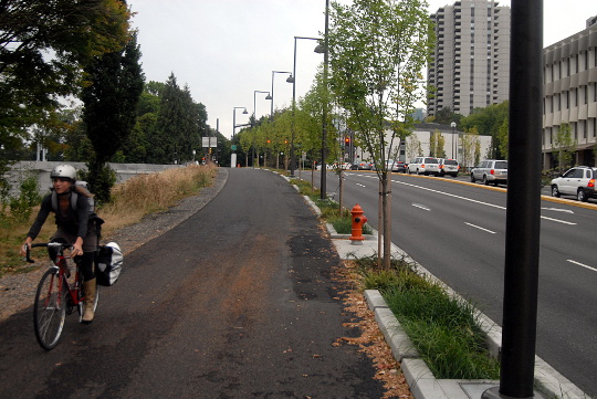
(Photos: M.Andersen/BikePortland)
Thanks to TriMet’s nearly completed Orange Line, the main bike route to the South Waterfront got smoother this week.
But as we discussed in a post last week, there are still significant complications with the bike connections to Portland State University that could have been solved if it had been possible to run a bike/walk/skate path on the new MAX viaduct.
I spent a while in the area last night, comparing the various route options created by the new northwest/southeast path that now links Moody Avenue and Sheridan to Harbor Drive and River Parkway. Let’s start with the good news.
Almost everybody who bikes into the South Waterfront should probably be using this path now.
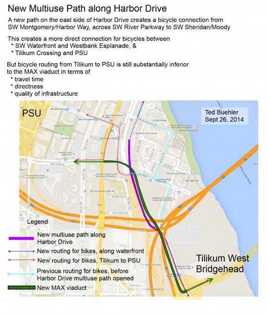
(Image and commentary by Ted Buehler)
It cuts the corner between Moody and the Hawthorne Bridge landings and lets you skip two traffic signals, including an awkwardly signaled intersection and a bunch of streetcar tracks.
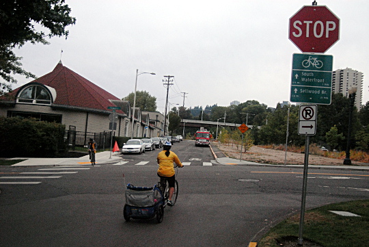
Most people biking to the South Waterfront from downtown or the east side head south through Waterfront Park until they reach this intersection (Harbor Way and Montgomery), then turn left. But as of this week, it really makes more sense to obey the wayfinding sign and go straight ahead:
Harbor Way dead-ends into a mixed-use path…
…which proceeds on the east side of Harbor Drive…
…and reaches the path built by TriMet for this purpose and opened this week.
Heading down this way, you’ll get a quick signal and straight shot across Sheridan into the Moody cycle track rather than dealing with the long signal and diagonal crossing across streetcar tracks that have been in use for the last few years.
Nice!
OK, now, the bad news…
Advertisement
It’s still slow and complicated to bike from Tilikum Crossing to PSU.
Last week, reader Ted Buehler argued that by far the best way to get to Portland State University from TriMet’s new bridge (and therefore from much of Southeast Portland) would be to bike or walk up the viaduct alongside the rails and busway … if only there were a path on that viaduct.
“It’s a Grade A Platinum Route from PSU to SE Portland,” Buehler had written in a comment thread about the apparent decline in biking rates among PSU students. “But not open to bikes.”
It’s not clear how hard it would have been to actually open that path to bikes. But Buehler is right.
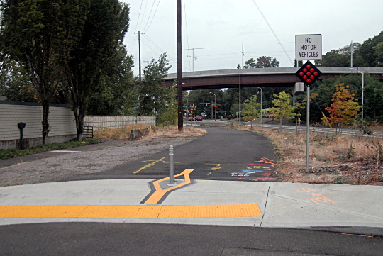
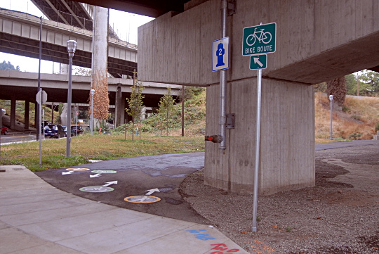
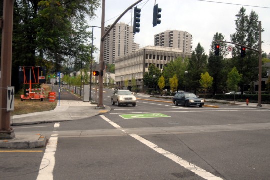
Let’s take the best existing route one step at a time, starting this time at the bottom of the hill, near the South Waterfront and the west landing of Tilikum Crossing. Here’s the view across Sheridan from the end of Moody’s awesome raised, separated cycle track:
There are new signs here urging people to turn left. They should!
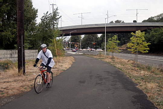
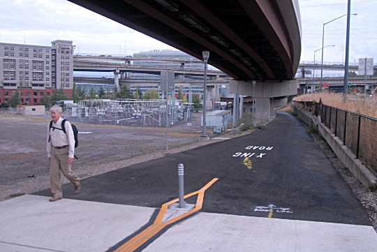
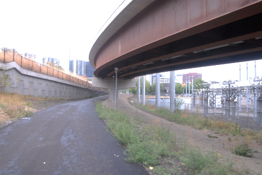
From there you can proceed up the path, just west of a power station and a vacant lot that seems sure to be a future Midnight Mystery Ride destination…
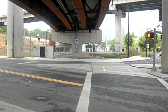
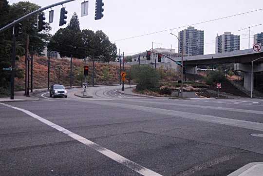
…and up to Harbor Drive, the stub of 1950s expressway that remained after Governor Tom McCall successfully led an effort to replace most of it with Waterfront Park.
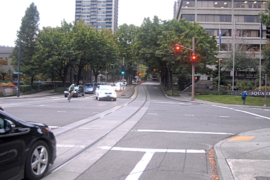
From there, someone biking uphill has to make a two-stage cross using the pedestrian signals, one of which requires a push button, into the bike lanes on Harrison Street alongside the combined streetcar/traffic lane. Those curve around to reach Naito Parkway, at which point you can continue straight onto Harrison and into the PSU area…
…unless sharing an uphill traffic lane with cars on a divided four-lane boulevard next to the streetcar tracks isn’t your thing. In that case, your best bet for reaching the much more comfortable Lincoln Street bike lane would be to turn left and wait through a long signal cycle to head over this crosswalk and onto the sidewalk here:
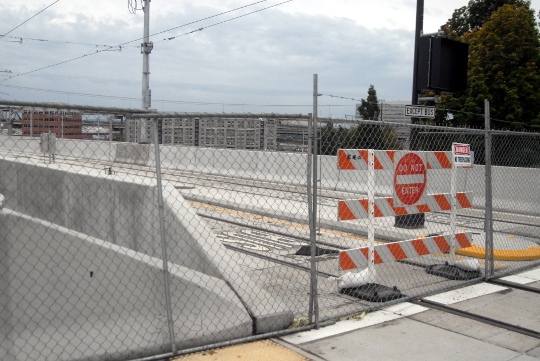
At the top of this incline, you’ll reach the new bike/walk crossing onto Lincoln. What’s that on your left?
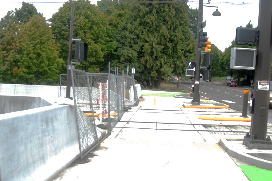
It’s the top of the new MAX viaduct that curves straight up from the bridge landing.
I timed myself biking up and down the legal route. It took 5:38 uphill, much of it waiting for the left turn crossing signal onto Naito from Harrison, and 3:01 downhill.
As for biking the viaduct, I would estimate (purely hypothetically) that it might take a similar rider about 2:28 uphill and 1:54 downhill, assuming that rider were proceeding carefully to avoid any track conflicts.
None of this is to overstate the importance of a minute or three in the big picture of someone’s bike trip. Like so much of Portland’s bike infrastructure, it’s good enough to serve those who are already riding, and it was certainly affordable. In a rail project that wound up furiously cutting $62 million at the last minute to make ends meet, that may have been necessary.
In an email Thursday, TriMet spokeswoman Mary Fetsch wrote that physical space was a problem, too.
“Designing a structure wide enough to include acceptably wide multi-use paths was not feasible due to the need for the structure to pass between freeway columns — the space between the columns limits the maximum width of the structure,” she wrote. “Even if possible within the physical space, a structure that wide would have added an estimated $5 million to the structure’s cost and necessitated access ramps to the structure in its southern section.”
Regardless, the bigger problem with the route TriMet settled on instead, compared to an MUP similar to the MAX viaduct, is that it’s the sort of thing that takes eight photographs to explain. Compare all these twists and turns through the shadows of highway and rail viaducts to the simplicity of “head up this path and it takes you straight there.”
That’s the sort of amenity that only money can buy.




Thanks for reading.
BikePortland has served this community with independent community journalism since 2005. We rely on subscriptions from readers like you to survive. Your financial support is vital in keeping this valuable resource alive and well.
Please subscribe today to strengthen and expand our work.
The biggest problem stretch is going up Harrison. I would love to see an extra little two-way cycletrack or MUP in that cuts through and connects with the top of the viaduct and the Lincoln bike paths. Then you wouldn’t need to do a two-stage crossing or ride in the narrow bike lane up the curvy stretch of Harrison.
Since that area is currently a grass filled lot that I believe PBOT already owns I don’t know why it wouldn’t be possible.
Interesting. You mean this hillside? It seems pretty steep.
https://www.google.com/maps/search/sw+naito+and+lincoln/@45.5074318,-122.6763023,3a,75y,240.17h,90.3t/data=!3m4!1e1!3m2!1s0ESrhB7SQGTAU957PeYpgw!2e0
PortlandMaps treats this area as if it’s a street, but I don’t know if that means it belongs to PBOT, ODOT or someone else. I don’t think this would have anything to do with ODOT’s planned addition of a freeway link between the Ross Island Bridge and I-5, but I could be wrong. Maybe someone else knows?
That’s the hill, it is somewhat steep but there’s a lot of room, a loop back would be easy enough to add and it would likely end up less steep than harrison is currently. You could also just extend the sidewalk a bit and follow that under the viaduct and then loop back before hitting Naito so that you come out at Lincoln. Either would be preferable to the bike lanes on Harrison and would provide a nice protected route all the way from PSU to South waterfront.
You’re right though, given it’s location between Naito and Harbor drive ODOT may be the more probable owner.
Thanks for adding the map.
The purple line I added here is what I’m talking about for a path up the hill:
http://imgur.com/1NKJUXm
Yeah, that’s really steep, possibly steep enough to require stairs.
Harrison west of Naito needs to be reduced to 1 motor vehicle/streetcar lane each way, with separated bike lanes, particularly in the uphill direction. Yes, the streetcar & buses will obstruct traffic a little, but there’s going to be a cost for safety, right?
Just a quibble: The Moody cycle track is less than awesome. Its surfaces and other visual cues are indistinct, so there is always someone walking in a bike lane. Also, its lane widths have been permanently pinched at the point where the Tilikum tracks tie in.
A huge frigging column completely blocks the view of cyclists entering from the north leading to significant risk for clueless peds/joggers/dogwalkers. I now enter south bound on the ped side because I’ve had to emergency brake several times to avoid colliding with peds/joggers.
There are also two pointless crossovers at the beginning and the end that confuse anyone who has not used the facility regularly.
The south bound one way lane bike lane is too narrow to pass other cyclists and PBOT bizarrely installed grates, trees, and non-pavement surface blocks between the lanes.
It’s hard to understand why a facility with so much open space allocates so little of it to cyclists!
I have a memory of a cross-section plan that I saw before construction. I seem to recall that the grates, trees and non-pavement blocks originally were to help separate the walking path from the bike lanes. Some genius must have made a running change during construction and shifted things so that the furniture separated the two bike lanes. D’oh! (Can anyone corroborate?)
The bike crossing on the north is the most poorly designed facility I have ever encountered, it really is a marvel that someone designed something so dangerous.
And it’s on the wrong side of Moody for both north AND southbound traffic.
I completely agree. What’s most upsetting is that it seems like actual good solutions would have been very easy to design, but instead we get the bizarrely knotted path with multiple signal crossings and no discernible logic. Boo cycletrack designers.
Can easily see this is not high quality bicycle infrastructure. Missing a golden opportunity. One would think the connectors to a non-car bridge would demonstrate high quality segregated bicycle infrastructure.
thanks for covering this new cycle path, there aren’t enough stories about new cycle paths opening in Portland. I wonder when the last one was? I’m a little confused about the exact route you took, maybe a map would help?
I like this idea. It would help to visualize the layout better for those of us not able to explore the new paths immediately.
Same. I opened up google maps and tried to follow along and quickly gave up.
Would this route somehow be a good way to get between SW Lincoln at 1st and the Hawthorne Bridge? Currently I’m biking down 1st when heading from the bridge but am taking Lincoln->Naito path->Harrison to go the other way, and that’s a pretty annoying detour.
Okay you guys, just because I love you I added a map to this post.
Thank you!
So it looks like it’s still pretty unpleasant to make a left from River Pkwy to the new route given the streetcar tracks- is that an accurate assessment?
this facility is a mup, not a cyclepath.
The people responsible for the dreadful design of the Moody Avenue rebuild were standing up front at the brown bag lunch last week (excluding you, Michael).
Why are those people never held responsible for their incompetent designs?
Be strong and fearless! Sack the lot!
All these pictures are of places that rarely (if ever) see. I never go to this part of town. However, I could use a good exploratory bike route! Thanks for posting.
Seems like the route problem boils down to getting from the River Pkwy-Harbor intersection to the Lincoln-1st intersection in a more direct way. A multi-use overpass would have to run about 800 ft. to get there, but I have no idea what it would cost.
“Designing a structure wide enough to include acceptably wide multi-use paths was not feasible due to the need for the structure to pass between freeway columns — the space between the columns limits the maximum width of the structure,” she wrote. “Even if possible within the physical space, a structure that wide would have added an estimated $5 million to the structure’s cost and necessitated access ramps to the structure in its southern section.”
What’s the answer to this? Isn’t better bike infrastructure always conceptually possible if money is unlimited and maximum roadway width is ignored?
My answer to this is the same as my answer to the similar argument about the Barbur bridges and why accommodating bicycles there is cost prohibitive:
Run an 8′ diameter acrylic tub (or two) for bikes. Suspend it from the side, run it over—or under—the bridge. Whatever. It won’t cost $5M (or $12M in the Barbur case).
http://bikeportland.org/2013/09/30/odot-region-1-manager-lays-out-barbur-road-diet-position-in-letter-to-commissioner-novick-94670#comment-4457888
Hanging an 8 foot diameter tube under the viaduct: requires the viaduct to be raised 8 feet, is incompatible with the viaduct supports, the steeper grade could be a problem for MAX, possibly overhead clearance issues for MAX too.
Cantilevering an 8 foot diameter tube off the side of the viaduct: structural support requirements, doesn’t solve the problem of insufficient space between overpass columns.
The 8 foot tube would be inaccessible to emergency vehicles. No sensible transportation agency is going to build a bike/ped path from which an injured person (accident, heart attack, etc) cannot be evacuated by ambulance.
Finally, you’re not being realistic about the cost of a mile of custom-made, suspended, engineered, 8 foot “tube” pathway able to support the weight of a dense crowd of people, all walking or jumping, with acceptable safety margins, and designed to last for many decades. Something very similar, 2 miles long, was proposed for a bridge in San Diego. Even the architect who proposed it estimated the pedestrian tube would cost $50 million.
http://blog.archpaper.com/wordpress/archives/56202
http://www.10news.com/news/elaborate-pedestrian-tube-proposed-for-coronado-bay-bridge-021413
If it was as easy as you think, it’d have been done.
They could have attached a MUP to the side of the structure as it crosses Harbor Drive, and then had it descent more steeply than the MAX flyover to meet the MUP that they just built under the flyover. This would provide direct access to Lincoln without creating a width conflict when the flyover passes under the Marquam Bridge supports.
“If it was as easy as you think, it’d have been done.”
Actually I think that is the problem. The easy stuff isn’t for ODOT. They want to make everything complicated and expensive.
That Coronado Bridge design is really cool. But you forgot to mention in your comparison that the bridge is 200 feet in the air and they were proposing a much fancier, larger, steel structure than I am suggesting, and think would be perfectly adequate in this or the Vermont Bridge/Barbur application.
I realize full well that a plastic tube adequate to support biking isn’t something you and I will likely install in a weekend, but I’m convinced that this could be done for a fraction of the price ODOT quoted for work they deemed necessary to adapt the bridges on Barbur to bikes.
These folks figured out how to hang a train from steel girders more than a hundred years ago: http://en.wikipedia.org/wiki/Wuppertal_Suspension_Railway
The only thing difficult here is the attitude that says
– too difficult
– too expensive
– if it were easy it would already have been done.
Let’s throw some staff brainstorming time at this, and then see if it really couldn’t be done for a reasonable amount of money.
As for money have you looked at what Salem’s proposed Third Bridge is supposed to cost? The one that is justified using ten-year-old and now completely obsolete traffic projections?
This is not just about the PSU students having good bike infrastructure, it is about communicating an attitude about being open and committed to doing sensible, innovative things with our public funds.
Makes no difference if you are suspending people 200 feet or 20 feet. Same structural and safety considerations.
I’d suggest the Coronado bike/ped tube design contemplates a steel structure of a certain complexity for a reason. Maybe because outdoor acrylic structures aren’t designed for a 100 year lifespan?
And I don’t see what point are you making by referencing the Salem third bridge cost, expected to be $100-140MM (bridge alone) or $350-400MM (total project)? Does that support your idea that adding a bike/ped tube to the MAX viaduct will be cheap?
“Makes no difference if you are suspending people 200 feet or 20 feet. Same structural and safety considerations.”
I’m no structural engineer, but I’d think that from a retrofitting bridge/installing the tube/worker safety perspective it would make a considerable difference, not to mention a cost difference whether you can use a hi-lift (work from the ground) vs having to stage everything from the existing bridge deck, 200 ft above the water.
“The cost estimate for [Salem’s 3rd bridge option] 4D is $687 million in 2015 dollars.”
http://thirdbridgesalem.blogspot.com/ (a pro-3rd bridge website)
My point in mentioning the cost of Salem’s third bridge was that for something utterly redundant and economically questionable ODOT seems quite able to assume 700M is going to materialize—money not currently budgeted anywhere–when in the case of adding real functionality to this bridge, which in any case would cost less than 1% as much, it appears no one even bothered to pencil out what it might have cost/could have cost.
The Wuppertal Suspension Railway is pretty cool.
https://maps.google.com/maps?q=Wuppertal,+Germany.&hl=en&ie=UTF8&ll=51.262371,7.173772&spn=0.006338,0.037208&sll=45.504091,-122.674402&sspn=0.00788,0.018604&hnear=Wuppertal,+D%C3%BCsseldorf,+North+Rhine-Westphalia,+Germany&t=m&z=16&layer=c&cbll=51.262372,7.17378&panoid=FBMCCQiFiBrCPYE8FRzK0A&cbp=11,245.27,,0,-9.11
& https://maps.google.com/maps?q=Wuppertal,+Germany.&hl=en&ie=UTF8&ll=51.267178,7.188728&spn=0.006955,0.037594&sll=45.504091,-122.674402&sspn=0.00788,0.018604&hnear=Wuppertal,+D%C3%BCsseldorf,+North+Rhine-Westphalia,+Germany&t=m&z=16&layer=c&cbll=51.267179,7.188724&panoid=8RyHpFHRE7SVNKuGjqYkZA&cbp=11,218.58,,0,-3.82
Wow, it’s like biking across the interstate bridge!
I explored this new MUP this morning SB from Hawthorne, and again as if I were riding NB from Moody. Doesn’t seem like it would suit anyone. Strong/fearless riders make frustrating detours, weaker riders are still forced into a lane with cars at Harrison (although Lincoln is better — but getting to it is tricky). Both kinds of riders have to do a lot of waiting at intersections including the ridiculous “wait through two red lights to turn left” maneuver. Golden opportunities were missed, like a cut-through to Lincoln like Daniel L describes above or improved SB lanes on Naito from the Hawthorne.
Despite this being in the middle of at least 2 daily routes for me & my family we will probably never use it. What a waste.
I’m not just disappointed, I’m insulted. This kind of afterthought infrastructure just underlines that bikes are squeezed in around the “Big Boy” transpo options like trimet and private cars. Especially with the viaduct going DIRECTLY FRICKING THERE. Maybe I’m tetchy but I’d rather be ignored than thrown scraps like this.
http://bikeportland.org/2014/09/23/panel-ponders-portlands-slide-cycling-superstardom-111205
From the map shown, I have learned that the Boy Scouts of America location is roughly 1 block from the Portland Center Liquor Store.
This has me wondering about a scale for bike routes along the lines of Geller’s “Four Types of Cyclists.” It might go something like this for current Portland build-out (flipping the percentage of his last two categories):
1% – If they won’t ride this, they won’t ride anything.
7% – OK for most people with more than a few months under their wheels.
33% – Works for most “Enthused & Confident.”
60% – Works for the “Strong & Fearless.”
The route in this article seems to me to fall somewhere in the 33%, maybe nearing the 7% category. To dig into Geller’s 60% “Interested but Concerned” people category, Portland needs to massively increase the fraction of those upper two infrastructure brackets.
Michael: The lead photo text uses a term “wide sidewalk”…a more correct term may be “MUP” or “path”.
Existence of post construction design discussions like this are what really separates true Platinum Bike Cities from Silver level.
I’ve made a diagram showing the new Harbor Drive Multiuse Path and how it helps connect Tilikum, SW Waterfront, PSU and the Westbank Esplanade.
https://www.flickr.com/photos/11599639@N03/15362432195/
Ted Buehler
I’m not fond of that purple route crossing 99. Looking in google satellite, there appears to be an underpass of 99 beside 405 – and it looks like from Harrison you can do a sidewalk-to-parkinglot connector to get to it. Not any more out of the way than the original red path, with the bonus of not having to wait for lights. Someone ride this & report if it works!
maybe we could just do a tunnel like they did in San Sebastian http://www.copenhagenize.com/2009/08/worlds-longest-bicycle-tunnel-opens.html 🙂
I find the parallel ride on SW Water (W side of Harbor Dr) a better choice. Thanks anyway!
you may be amused to note this post was referenced in the OHSU staff newsletter as a way of informing their employees about the path.
The North Macadam Transportation Development Strategy of 2009 (http://efiles.portlandoregon.gov/webdrawer.dll/webdrawer/rec/4567649/) has a number of bike pedestrian projects, including BP-2, which is listed as a “high priority”. The description is “New pedestrian/bike connection between 3rd Ave and Water Ave, passing along south side of The International School and under I-405. The connection will tie into South Auditorium trails.”
Now that PSU plans on redeveloping the University Place Hotel site, it would be an excellent time to resurrect that plan. It would connect the Moody cycletrack with PSU by a very direct route. I think it’s also one of the route options being considered as part of the 2035 Comp Plan “Green Loop.”
After reviewing all the comments, checking out Google Satellite images, and field checking a few things, I think there is an excellent, low-cost solution to the Tilikum => PSU quandary.
The legs are this, I’ll probably be able to field check it in a few days.
From the East Tilikum Bridgehead —
* North on Moody Cycletrack to Sheridan.
* West on Sheridan to Water (PBOT/ODOT could remove parking on the south side of the street and create a multiuse path, or 2-way cycletrack).
* Go north on Water St. to either Caruthers, Sherman or Water Culdesacs.
* Build a multiuse path from one of these culdesacs on the “West Naito Lawn” up to the Naito Parkway at Lincoln St.
The right-of-way exists. The grades are reasonable. There would be no signalized intersections, and only one or two stop signs. You wouldn’t sail above the fray on a wide path with a constant grade and nice views like TriMet does, but you could definitely get from Tilikum to Lincoln @ Naito with little muss or fuss.
If this route works, we should all be a bit disappointed that it wasn’t built as part of the Tilikum project, but we should be pleased that with a little effort we should be able to convince PBOT/ODOT/TriMet to construct a first class bike facility on this corridor in a year or two.
Ted Buehler
That should be *East* Naito Lawn.
& poking around a little more on Google Streetview, it looks like Caruthers and Sherman are way too steep to be a reasonable bike route. But the tail end of Water is okay, and could have a path with one switchback on it to get up to the Naito elevation.
& a connection from eastbound Harrison would allow bicyclists to cut over to Water/Sheridan to get to southbound Moody. Since Sheridan goes under Harbor Drive, bikes would avoid the annoyingly long traffic light crossing Harbor Drive at Harrison.
This
https://maps.google.com/?ll=45.507178,-122.676569&spn=0.002773,0.004651&t=h&z=19&layer=c&cbll=45.50718,-122.67639&panoid=ae_XHbQnGwfS95VH8RMZTw&cbp=12,304.47,,0,13.55
is the point of magical contact, the NW terminus of SW Water St. There is a road/path connection from here going south that connects to the Tilikum Bridge without any major street crossings. And to the north and the west, there appears to be public right of way to connect this cul de sac to either
* Naito Parkway, with a switchback on the lawn,
* SW Harrison at the Harbor Drive traffic signal, with a short sidewalk connection, or
* Naito at Lincoln (where the Platinum resumes at the top of the MAX viaduct) by running a path up the lawn to the top of the viaduct, possibly under the viaduct itself then doubling back.
None of these are as good as routing on the viaduct itself would have been if we could go back in time. They all have a bit of steep grade, and probably a squiggle. But all are much better than any of the options currently available from Tilikum West to PSU. They are pretty direct, they avoid all major surface streets, and they have no traffic lights.
FWIW,
Ted Buehler
BTW, these ideas are essentially copied and expanded from Daniel L’s posts — 1 & 3 in at the top of this thread.
I have read all the coverage lately about how poor the cycling paths are when compared to the viaduct.
Today, I had a chance to find out first hand as I have a class at the CLSB on the waterfront and also live on the stretch of Lincoln Street between 1st & 5th.
I rode the new paths, and then rode up next to the streetcar alignment. Then turned back up the new MUP and up to Harrison and while it is a bit of a jog, it is mostly seemless. Also of note, the grade on the MUP is much less than that of the viaduct (based on visual observation). I ride a single speed, so the more gradual grade of the “Harrison jog” was desirable.
All tolled, I had myself built up to find a terrible ride up to SW Lincoln. In the end, the only thing that sucks is that you have to sit and wait forever on the light to allow cyclists to cross Naito.
Just my thoughts. From someone who lives in the heart of this and will be using it often.
Curtis — thanks for the on-the-ground report. I’m glad that the exisitng route was satisfactory for you.
To clarify, did you actually ride up the MAX viaduct from Tilikum West to the concrete barriers at Lincoln? Or just eyeball it.
The time cost to not having bikes on the viaduct may be somewhat mitigated by the factors you mention — most of your energy is spent climbing, not moving forward. So adding additional length on the uphill leg may not be all that penalizing vs. the viaduct route. Penalized time-wise for waiting at traffic signals, but not penalized so much for out-of-direction travel because so much of it is on an upgrade anyway.
But, from PSU to Tilikum, the time penalty would be much greater, since a bicyclist could zoom down a [well-engineered] path on the viaduct at 30 mph and go from Lincoln/Naito to East Tilikum in 1 minute, vs. the 3 minutes reported by Michael on surface streets.
This 2 minute gain represents 0.3 miles of travel at 10 mph. When folks are making a decision as to whether to bike, drive or take transit, the omission of a bike path on the viaduct automatically moves all eastside students 2 minutes, or 0.3 miles, further from home. And add the headache of waiting for the light at Harbor Drive. This delay and “friction” will push some commuters over the threshold from bicycling to transit or driving.
Ted Buehler
I didn’t ride up the viaduct. I would hate lifting my bike around the fence. But the ride up the new path and then up the Harrison jog was pretty easy. Sitting down on the single speed even.
Tonight I rode up next to Naito and looked over at Harrison and the viaduct and still feel that the grade of the viaduct might make it tough to cycle up. Maybe with extra gears it wouldn’t be too bad, but who can say. We do live in a city of hills after all, so maybe it wouldn’t have been a big deal.
I’m happy they’ve opened this path – it makes the transition from downtown to Moody much better. However, I wish they would rethink the lights at Harbor Drive and River Parkway. There’s an extra lane northbound on Harbor Drive to allow drivers to turn right (East) onto River Parkway. The crosswalk lights, which are what bicycles traveling along the path system have to use, are not timed to allow a rider to cross the street in one action. It forces cyclists and pedestrians who obey the signals to stop in the sidewalk island in the middle of the street and wait – whether you’re going from the new path to Harbor Drive or vice versa. All this is just to allow the few cars that are turning right at that intersection to travel with the green light for cars continuing into downtown. It would be much easier if that right turn was a yield sign instead of a light, or if cars turning right had their own time to turn separate from the walk signal timing.