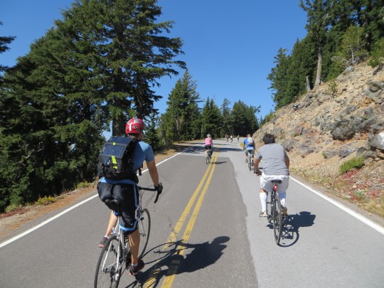
(Photos by Rebecca Hamilton)
As we mentioned in the Weekend Event Guide, Saturday is the last day this year to experience a carfree ride around Crater Lake. Contributor Rebecca Hamilton experienced it last week and has some tips to share.
Crater Lake National Park will host its last carfree day of 2014 this Saturday, September 27th. Although the West Rim Drive will remain open to motorized vehicles, the East Rim Drive’s 24 miles (of the 33-mile loop) around the caldera rim are yours to enjoy on foot or two wheels without a single stop sign or RV along the way.
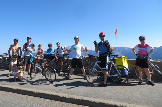
I joined a group of Portlanders who traveled south and tried this out last weekend. We picked up a few tips worth knowing if you decide to go:
Timing
It took two fairly strong cyclists on road bikes about four hours to complete the loop, which included generous time spent stopping at overlooks and reading informational signage about Park ecosystems. Experienced cyclists who don’t care about scenic beauty or the lifecycle of the Clarke Nuthatch could ride it much faster; but why rush? Stop for the vistas and save the wind sprints for the less breathtaking stretches of road in your life.
Check the weather
At 7,000 feet, the weather can make or break your day. While our group last weekend enjoyed blue skies and 85-degree weather, it’s telling that no one who went on last year’s September carfree days would even consider the invitation to go again due to traumatic memories of something they referred to as the “thunder snows.”
It’s not the Springwater Corridor
You’ll be doing + 3,000 feet of climbing and the elevation adds an extra challenge for those accustomed to breathing the oxygen-dense air of Portland. The loop won’t faze a determined commuter but this is definitely not a beginner’s ride.
Ride counterclockwise
For 90% of the ride, one direction is as good as the other. If you go clockwise, however, you’ll be ending your peaceful, pleasantly exhausting ride with 3 miles of climbing up a 4% grade in steady traffic. It’s do-able but feels like ending a yoga class with a fire alarm. Bonus: if the day is hot, the counterclockwise trip will put you at the Cleetwood Cove jumping/swimming spot at about mile 22 of your ride.
Road bikes are recommended
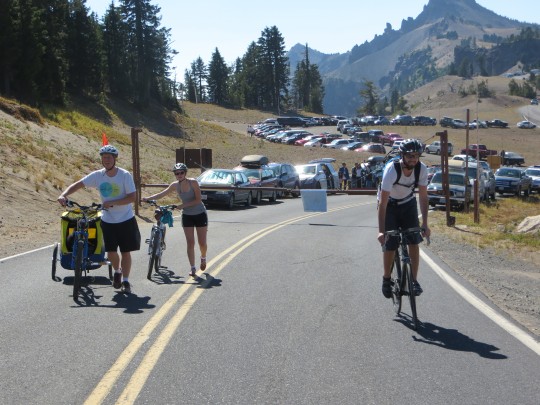
This is a ride of both long, sustained climbs and glorious 5-mile descents, so an average rider may be most comfortable on a bike with a wide gear range and thinner tires. All our mountain-bike riding friends made it, however, and we did see a few SuperParents riding with kids on tag-alongs. Anything is possible if you’re willing to put the work in. The people on tandems looked like they were having most fun, at least on the downhills.
Check your brakes
Most of the descents are less steep than what you’d find coming off of the West Hills, but they’re long and you pick up a lot of momentum after several miles of downhill. There are also a number of places where the road has been damaged by freeze-thaw cycles or rockfalls that require quick responses when you’re travelling at speed. Replace borderline brake pads and tighten loose cables before you go.
It’s a real volcano
There aren’t any snack vending machines or drinking fountains along the way so bring what you need. There is a primitive restroom located halfway around at the Whitebark Pine Picnic Area.
Go
It’s no understatement to say that this is one of the Great Experiences of Oregon. The chance to bike around the rim of a car-free Cascadian volcano caldera filled with a lake that created its own shade of blue is either why you moved here from Iowa or why you’re native Oregonian and will never leave. Just be sure to check the weather report for those pesky thunder snows.
Here are a few more resources:
—Official Crater Lake National Park Bike Map (PDF)
—GPS of the counter-clockwise route with elevation profile
— Official National Parks site: Vehicle Free Days on East Rim Drive
Have fun! And make sure to comment or Tweet @BikePortland to share your photos and reviews of the ride.


Thanks for reading.
BikePortland has served this community with independent community journalism since 2005. We rely on subscriptions from readers like you to survive. Your financial support is vital in keeping this valuable resource alive and well.
Please subscribe today to strengthen and expand our work.
Great timing, gang. Only about a week after the event started. Thanks.
Hey Alex,
This event didn’t exactly start last week. There were two days this month that the NPS made carfree. Last Saturday and this coming Saturday. Perhaps we should have made that more clear.
Alex, this event was published on this very website on 9/18 as part of the weekend guide. And back in June this website also published the NPS announcement of these dates. Cheers.
Did this last week and had an amazing time! Started from the Diamond Lake campground, which let us ride right through the gate passed the long wait of cars, but added 14 more miles and about 2,100 more feet of climbing. One hell of a return trip though!
My main advice would be to bring tons of water, preferably a camel back. We rode counter-clockwise with two water bottles filled each and admittedly did not think the ride was going to be as climbing intense. After the lodge, we had the majority of the rim road left and only the two water bottles full of water. Definitely not enough and no places to refill until returning to the gate (and even then, just asking for people loading up their cars if they have extra water).
Besides the water mishap, we all had a blast and was one of my favorite rides. It was so great seeing so many cyclists of all types enjoying this National Park without worrying about cars. I hope they continue to do this every year!
FYI, if you are going counter-clockwise, there are sections of descent filled with potholes and gravel. Keep a lookout for them when blazing down descents, else you will have a bad time.
Yes, I agree on camping at Diamond Lake. If you camp at Mazama Campground, it’s a lot more driving.
If you don’t want to haul water, snacks and extra clothing, the Crater Lake Century is a supported, charity ride held every August. It’s not car free, but it is a great ride.
http://craterlakecentury.com/
I second the no water comment. I’ve done it twice, both counter clockwise, once with a gallon of water strapped to a back rack. It’s not just that there are no drinking fountains, there is NO RUNNING WATER until you get back to the beginning. Also, to those who like the idea of a midride swim, keep in mind it’s a mile down to the water with about 700 feet of loss/gain.
http://www.craterlakeinstitute.com/planning-visit/activities/trail-cleetwood-cove.htm
As a final downer, much of the East and South side of the ride has limited views of the lake, so less adventurous riders (assuming counter clockwise travel) may consider an out and back. All that said, it is truly an amazing ride that all Oregon cyclists should do at least once.
Sorry, I meant clockwise, not counter.
There are water fountains and bathrooms at the visitor center.
Looking for a ride down there tomorrow. I will pay for the gas, and have a campsite reserved.
Another reason why I refuse to let Mrs Dibbly sell the Santana!
(Is it just me, or do Thunder Snows sound awesome?)
Interesting about the counter-clockwise thing. We were there just this last weekend in our van on our way back from California and encountered a mom and daughter riding clockwise. We picked them up on the southeast side of the crater (a bit past the Pinnacles turnoff) and they looked exhausted and were walking their bikes up the long hill. They were ever so grateful because they had underestimated the effort to make it all the way around, having started at the junction road on the northwest side.
They were from the Bay Area and doing a mother-daughter trip to Ashland, Crater Lake, and finally Portland. So, good Karma points earned there. I actually ran into them at the food carts on my lunch break a few days after that, waiting for food at the same torta cart. Hilarious serendipity.
That was my first ever visit to the crater and it was done on a whim on our way home from Ashland that morning. I had all kinds of wonders about where to park and best ways to do the ride on some car-free weekend. Thanks for publishing the tips. Bookmarked!
Also, there are some sections of the road that are pretty torn up right now from rock fall and are under repair – so do expect some road crews and some particularly bumpy, pot-holed sections.
agreed on the counter clockwise. did this some years ago and it was harder than I expected even though I had studied the elevation changes. Great ride!
Good input, thanks all. Sounds intimidating and I apparently brought the wrong kind of bike. But looking forward to the ride none the less. BTW does anyone know if is their cell coverage? I will have to connect with another group for my ride back to Sun River.
Cell coverage is pretty spotty. It might depend on your carrier, but with T-mobile it was mostly no coverage, with an occasional 1-2 bars at random spots.
Pshaw, I have a friend who rode it last weekend on a swing bike. Pretty sure it’s the one he built with the bbq grill on the front rack.
There’s no wrong kind of bike, just not enough preparation. 🙂
The forecast for Saturday is high temp of 48 degrees. Sunday is forecast high of 56 degrees. High temp each day is at 4:00 pm, much cooler in the morning.
Counter-clockwise might be the way to go (it was certainly pretty grueling for our group who went clockwise), but it’s worth it to note that by doing so, you are on the outside rim of the crater, and will have to cross over every time you want to go to one of the lake vista points (and in general won’t see the lake as often/easily while you’re riding). I’ll admit, as someone who is a somewhat experienced city rider, the route was pretty strenuous. Be prepared and bring lots of water and snacks!
A few notes from my experience last weekend —
4 hours is doable for folks in good shape. But if some of your party is in only fair shape, better allow at least 6 hours. And bring lots of water, food and snacks.
Minimal cell phone coverage. Plan on using pay phones, and leaving messages with a third party if you’re trying to meet up with people. Otherwise you’ll spend a lot of time frustrated, trying to eke out data from a weak signal.
Counterclockwise is the way to do the whole loop. But, if you’re just doing the car-free section, you can leave a car at the NW junction, ride clockwise, and just have one member of your party turn around halfway to pick up the vehicle, and you get a long descent at the end of the clockwise movement. I did this with friends with very satisfactory results, including the final 4 miles of pure downhill from the SW junction down to the campground.
Make your campground reservations early for the Mazama Village campground. Or just camp at Diamond Lake.
Swimming was epic, bring goggles if you have them. I bought some corrective lens goggles earlier this year, and seeing the underwater drop-off, strewn with boulders and logs, disappearing into a deep blue, was one of the coolest things I’ve done in a long time.
Ted Buehler
If you are camping at Mazama village, I found that clockwise was the way to go. Leave early for the brutal climb up to the lodge, and ride the west rim early while traffic is low. The finish is all downhill back down to Mazama.
We rode it last weekend clock -wise pulling two trailers with children in them. The climb at the end did suck, but we were able to fill up our bottles at the lodge before the last long climb. We stayed at the Diamond Lake Resort but drove over to the Park. If we don’t have the kids with us we could’ve ridden. Here are some photos from our trip. https://www.flickr.com/photos/jordan_n22/sets/72157647875536411/
It was an awesome trip and very recommended!
“an average rider may be most comfortable on a bike with a wide gear range” Sounds like, for some riders, a good reason not to bring a road racing bike.
Mountain bikes have a wider gear range than even most road triples, and far more than most road doubles. Mountain bikes would have a speed disadvantage when equipped with standard knobby tires at lower pressure, but that’s easily fixed.
We did the ride last saturday going ccw, starting at the Steel Vistor center. It’s 3800ft of climbing if you do the full 33 mile loop. Starts with a long uphill, ended with a long downhill. Some more thoughts/tips:
– There was hardly anywhere in the immediate area we stayed at (Ft Klamath) to buy food. Make sure you bring your own if staying there.
– It took us about 5.5-6 hours to get down there from Portland. We got stuck in heavy evening commute traffic until around Wilsonville and behind several trailers going up the mountains. Had to call our hotel to let them know we’d be a little late.
– The whole ride took us 7 hours making several stops including a long nearly hour lunch break. We ride quite a bit in Portland, but weren’t quite in the best shape and ended up doing a lot of walking uphill.
– We started the ride way too late at 1pm. The East Rim drive reopened to cars at 5pm and almost immediately there were cars on the road. It was also dark when we finished; luckily we had lights.
– Also underestimated how much water would be needed. I think next time I would try to bring 3 good size water bottles.
Overall it was fun, but the hills were grueling. Hope to do it again some day.
I did the ride last weekend CLOCKWISE (along with most others) this seems the best way. To avoid the long hill at the end- park at the special parking lot for cyclists just south of Steel Information Center. Start early (we started at 8:30am) so you get all the riding with traffic out of the way when it’s early and less crowded. Check the wind conditions- a headwind could really be a bummer and may impact how far you want to go.
One can only dream of the day when the car-free Crater Lake ride can actually be accessed by car-free people…
With “Getaround” you can be have the benefits of car travel without car ownership.
Sure, you still need to drive places like Crater Lake, but you don’t need to own a car, find a friend to give you a ride, or pay commercial car rental rates.
$40/day, $200/week is the going rate for a Subaru Wagon.
I figure I used to spend about $2000/yr on non-gas costs for my lightly used elderly Toyota station wagon. At that rate, I could rent someone’s Surbaru on Getaround for
* 3 weeks ($600)
* 10 weekends (2 day) ($800)
* 8 days ($320)
* 30 hours ($240)
for a total of $1960, and still stay ahead. And in reality, the most I’d need would be half that, so I’ll save $1000/yr.
&, FWIW, my car broke down on the way home from Crater Lake one year ago. So I’ve been car-free for one year now. I’ve used Car2go three times and carpooled a bit. But mostly biked, trained, bused and flown instead. I haven’t tried Getaround yet, but I do miss the weekend trips.
Crater Lake, nab yourself you neighbor’s Subaru wagon, and you can do a 3-day trip for $120.
Ted Buehler
Clockwise has the advantage that you’re riding on the lake side of the road, with considerably better views into the crater as you go around, and all the pullouts are on the right.
I’m in Chemult now looking forward to riding in the morning. Forecast is mid-30s tonight warming up to a high of 55 tomorrow. I can’t wait!
A few thoughts:
Although riding counterclockwise is easier, clockwise gives you better views of the Lake while riding. It is also great to get past the patches of bad road going uphill instead of downhill and you can get water at the Visitor Center before climbing back up to the Lodge and on to wherever you parked. Riding up to the Rim from Diamond Lake Campground is a great experience! I love this ride and so appreciate the car free portion. I can’t wait to do it again next year.
Thank you for this! I’m considering doing this next Saturday and am looking into logistics – this is quite helpful!
http://ridetherim2015.com