(Image: ODOT)
Last week the Federal Highway Administration announced $19.5 million in transportation project grants throughout Oregon. One of the funded projects is 1.6 miles of paved path (for biking and walking only) along I-84 in the Columbia River Gorge.
Since the Gorge is such a popular place to ride (and I bet even Bill Walton doesn’t like riding on the shoulder of I-84) I figured the project was worth a closer look.
The new path is part of a $50 million project to renovate the Historic Columbia River Highway. Back in 2007, I joined Jeanette Kloos from the Friends of the History Columbia River Highway for a glimpse into a section of the project further east. Thanks to Jeanette and the Friends group, just 11 of the 72 mile length of the Historic Highway remain.
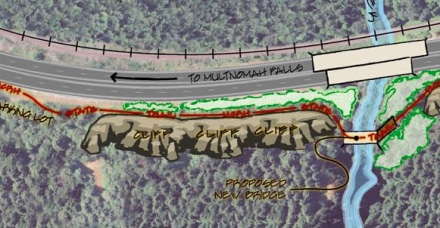
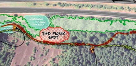
This latest FHWA grant will pump $2.1 million into a segment of the path from John B. Yeon State Park at Warrendale to an already restored section of the Columbia River Highway State Trail at the Moffett Creek Bridge.
The big news for people riding bikes is that they’ll no longer have to use the shoulder of I-84 between Troutdale and Cascade Locks. In fact, once this trail is complete, you’ll be able to ride 34 miles between Troutdale and Cascade Locks completely on a mix of the Historic Highway and the State Trail. This new path will also complement the existing US Forest Service Trail 400 and will connect users with a hiking trailhead at Elowah Falls.

Construction on this path segment is set to begin February 2012 and should be done by summer 2013. For more information, check out the Oregon Department of Transportation project page.


Thanks for reading.
BikePortland has served this community with independent community journalism since 2005. We rely on subscriptions from readers like you to survive. Your financial support is vital in keeping this valuable resource alive and well.
Please subscribe today to strengthen and expand our work.
Will the entire 34 connected miles be paved? I’m not familiar with the US Forest service trail. Just wondering about suitability for road bikes.
The new section of the trail will be paved, as is all of the existing gorge trail. But FS trail 400 is a hiking trail and is not paved.
I’m so stoked about this getting funded! This link has been sorely needed.
In my experience FS 400 gets more use as a Mountain Biking trail. Although, it is designated for hikers and bikers.
Hallelujah!
That’s incredible! I’m so happy!!!
That is awesome! I love riding out in the gorge, and I’ve never had a problem using the shoulder on the historic highway, but I have zero desire to ride along I-84.
This is fantastic news. I can’t wait!
Does this get rid of the need to use the stairway to get up to the trail above I-84? That is a major bottleneck with larger bikes loaded for touring, velomobiles, etc.
No, not as a part of this project. Here’s the link to the segment you’re referring to. I agree this needs to be the next step, as it’s a pain with just a road bike; I can only imagine what it’s like with a loaded touring bike or with a trailer!
But providing a safe way across McCord Creek removes the most dangerous part of the existing route and rightly deserved to be done ASAP. Riding on the shoulder of I-84 is annoying, but it’s pretty wide and safe, other than on the McCord bridge.
http://www.oregon.gov/ODOT/HWY/HCRH/docs/Reconnection_seg1a.pdf
Now If we can just get the state parks to designate hiker biker campgrounds along the gorge as well….
Those state parks do honor the hiker biker rates. Two summers ago I was biking back towards Portland and camped out there. Not seeing the familiar hiker-biker rate listed, I ponied up the full amount ($17?).
I was awoken early with a “knock” on my tent from a ranger giving me a refund for the difference!!
Tb & SS, I know several people, myself included, have asked State Parks’ Bike Recreation Coordinator Alexandra Phillips (alex.phillips@state.or.us) to look at siting a hiker/biker camp at Ainsworth (closest campground to Portland metro) and any/all other State Park campgrounds in the Gorge. You may want to add your voice with an email to her. They really moved fast on adding one to Willamette Mission State Park http://www.oregonstateparks.org/park_139.php it’s actually there, just not well-promoted on the website -so there is hope for Parks to do something in the Gorge.
Glad to hear they’re honoring the $5 bike fee, but the real issue for cyclists is finding a “normal” campsite space during a summer weekend. The beauty of the hiker/biker campsite is that you just don’t have to worry about availability.
Thanks for the contact info, I will shoot an email that way when I get the chance!
The State Parks website now claims that Ainsworth has “primitive” (I think their term for hiker-biker?) sites: http://www.oregonstateparks.org/park_146.php
GB, I think the “primitive” sites are open to someone arriving by motor vehicle – you just can’t drive right up to the site, so you have to schelp your gear a (short) distance. So I’d bet these are filled most summer weekends.
And when you email Alex Phillips, be polite – she’s been a tireless force at OPRD for improvements, and Parks has added to her responsibilities, so she’s one busy person.
Also as a note – the situation with the State Parks in the Gorge isn’t easy to remedy or modify – the Columbia Gorge National Scenic Area has hundreds of landowners and something like 17 major stakeholders who have to sign off on any major changes – the whole area is regulated at local, state and federal levels. This project took decades to get to where it is today, and while we shouldn’t rest easy and should continue to press for better biking facilities, we should also bear in mind the challenges to put them in and to have realistic expectations.
Excellent! I’ll never forget the walk home to Portland after a summer on the PCT and coming to Moffett Creek/I-84 shoulder walking. Finally one of the worst gaps in the Portland-to-PCT ped link will be closed.
That proposed trail reconnection at Eagle Creek vs. the existing stair will be a great improvement.
It really was ‘sucky’ to have to unexpectedly portage a loaded touring bike down those stairs. I am glad I did not have the family touring with me…as I would have been tired carrying everyone’s loaded bike at the end of a long day riding.
all fine and well, but I will really be doing the hallelujah when some real transportation trails get funded. npGreenway and Sullivans Gulch to start off with.
I know, different pots of money. And I shouldn’t be raining on their parade.
However….
I’ve never ridden the gorge on the Oregon side, playing fender tag on the shoulderless freeway bridge isn’t my idea of a good time.
At the Oregon Active Transportation Summit in March I spoke with the ODOT rep on this, she assured me that it would all be engineered to a high standard. I looked at the drawings, but couldn’t tell if it was free of blind, sharp corners and steep hills like you sometimes find on multiuse paths that are built as an “afterthought” to the roadway.
I hope they do a good job of it, and I look forward to riding my bike to Cascade Locks after it’s done.
Ted Buehler
I recently hiked the Ruckel Creek Loop and part of the hike included a walk along the already paved section of the HCRH near Eagle Creek.
The trail is in terrible condition. Tree roots have buckled the trail raising sharp, 3 inch bumps in the pavement. Blackberry vines hang in the right of way and dirt and sand from landslides take away significant road surface from folks riding road bikes, or those with thin skin.
Why are MUP’s built to such poor standards? The surfaces laid down would last many more years if the subsurface treatments were improved. I mean, trees grown near freeways and highways but I don’t see their roots cracking the center lane.
I hope there is a plan to maintain this trail, not just launch it with a quick grade and blacktop.
B-M-B, you raise a good question – is the (paved) trail maintained by ODoT, or State Parks, or..?
Oregon Parks and Recreation Department maintains the Historic Columbia River Highway State Trail, with the exception of “major structures” that are maintained by ODOT. A list of needed repairs is being made; hopefully, there will be some improvements made next year.
Sounds to me like it is a bikepath, not a “trail”, so leet’s quit calling it a trail.
I agree Terry. Trail is such a common (and the official) way to refer to projects like this that I sometimes defer to it as a matter of clarity for readers… But I don’t like the word “trail” either (unless it’s actually an off-road/hiking/mtb trail). I went back and changed the headline and the story text. cheers.
I’d like it now. 🙂 I ride this area several times a year. The westbound mile to Warrendale on I-84 isn’t so bad, but the longer eastbound stretch on I-84 – yuck.
i hope they install signage that cyclists are on the roadway and to share the road in dangerous sections of the historic hwy 30. limited sight lines, narrow lanes with no shoulder and cars still passing in these areas even with a double yellow line make for a dangerous ride. several times i’ve been in a group of cyclists where drivers refused to obey common sense (and the law) and nearly ran folks into the ditch!
Right on Well said!
Not addressed is the longer question: At what point will a rider be able to ride a bike, without portaging on stairs or using the freeway shoulder, all the way from Troutdale to Hood River and back?
Next to Hood River, the Dalles and beyond!!!
The Friends of the Historic Columbia River Highway have the goal of reconnecting all of the highway so that you can ride a bike from Troutdale to The Dalles without being on Interstate 84. If you want to become involved – or donate – visit http://www.hcrh.org.
I have ridden I-84 to Portland about four times. The worst part is the 2 foot wide shoulder around Shell Rock Mountain. It scares me to death. The east bond lane with it’s retaining wall and blind curve is far worst then the west bond lane Which runs along the railroad track and guardrail Will this Trail come all the way over to Hood River? And if yes When? Thank you for all the great work you have done so far. I ride The Mosier Twin Tunnel all the time.
PS. The stairs at Tooth Rock are very hard to get a Packed Recumbent up or down. But I will put up with it because the alternative going threw the tunnel would be death.