A parent should be able to send their 12-year-old to a day at summer camp or to run an errand by bike without worrying about them getting hurt (or worse) in a traffic crash. Especially if those destinations are along a regional path managed by agencies who say they care about climate change.
That’s what Tina Ricks thinks. It seems like a simple thing, but after months sloshing around in the bureaucratic mud, she has found out it’s anything but.
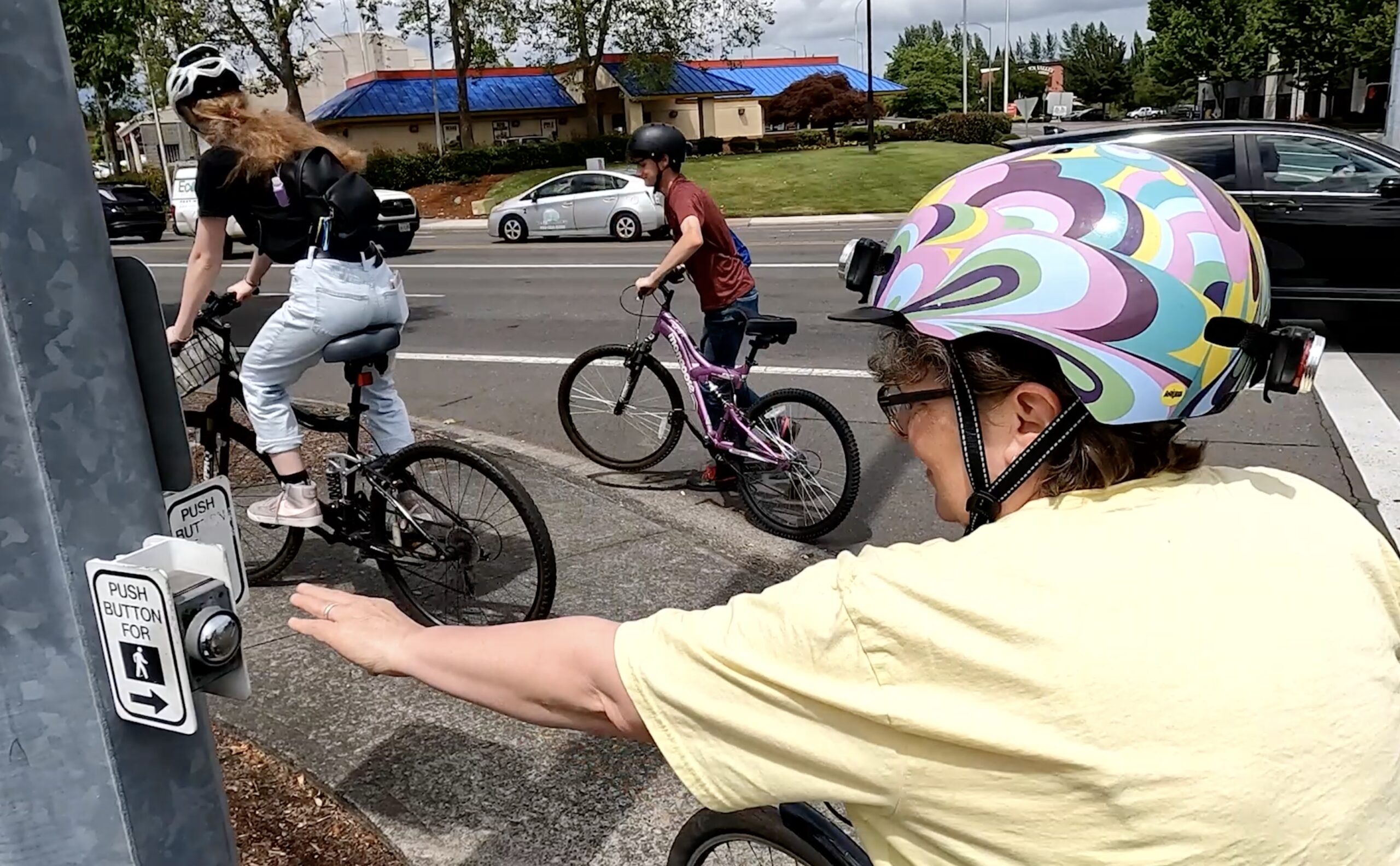
Ricks (@tinaintheburbs on Twitter) is on a mission to make the Waterhouse Trail a safe and feasible option for bicycle riders of all ages, and a key part of making that happen is to close a dangerous gap in the path where it crosses Highway 26 on NW Bethany Blvd between Bethany Court and Bronson Road. It’s just ¾ of a mile but it’s a deal-breaker for all but the most confident and patient riders.
I met up with Ricks recently to learn more about what she’s been working on and see for myself how bad current conditions are.
The Context

The Waterhouse Trail is a 10-mile paved path that follows a powerline corridor between housing developments from the 158th/Merlo MAX light rail station in Beaverton north to Bethany (unincorporated Washington County). It’s typical of the many paths in this area in that it’s a very mixed bag when it comes to bikeway quality.
Some spots are sublime, but in other places the path is either too narrow, full of bumps, has way too many turns, has awkward and unsafe street crossings, or some combination of all of these.
The section Tina is most concerned with is where the path ends into an industrial park near the busy intersection of NW Bethany and Cornell Road. From there, people are taken from the quiet and carfree path and dumped onto a stressful street shared with drivers where path users are barely an afterthought.
Adding salt to the wound is that the industrial area where the trail ends is full of kid-oriented destinations. There’s a pediatric care office, a martial arts studio, a gymnastics school, indoor soccer facility, and a daycare center.
About a mile east, Metro, Tualatin Hills Park and Recreation District, and other agencies plan to build a new carfree bridge to connect the Westside Trail over Highway 26, but that won’t help this gap and likely won’t be built for several more years at least.
Riding The Gap


On Bethany Court, at the path’s southern terminus, parking is allowed on both sides of the street despite parking lots in every direction. “I counted 459 spots on Google Maps,” Tina said as we rode, “But people still want to park on the street.”
A current plan from the City of Beaverton would limit on-street parking to just one side. But Tina is pushing to remove all of it. (At least one Beaverton City Council member seems to support her. “I like your thinking around no parking,” Councilor Nadia Hasan shared in an email to Tina last month.)
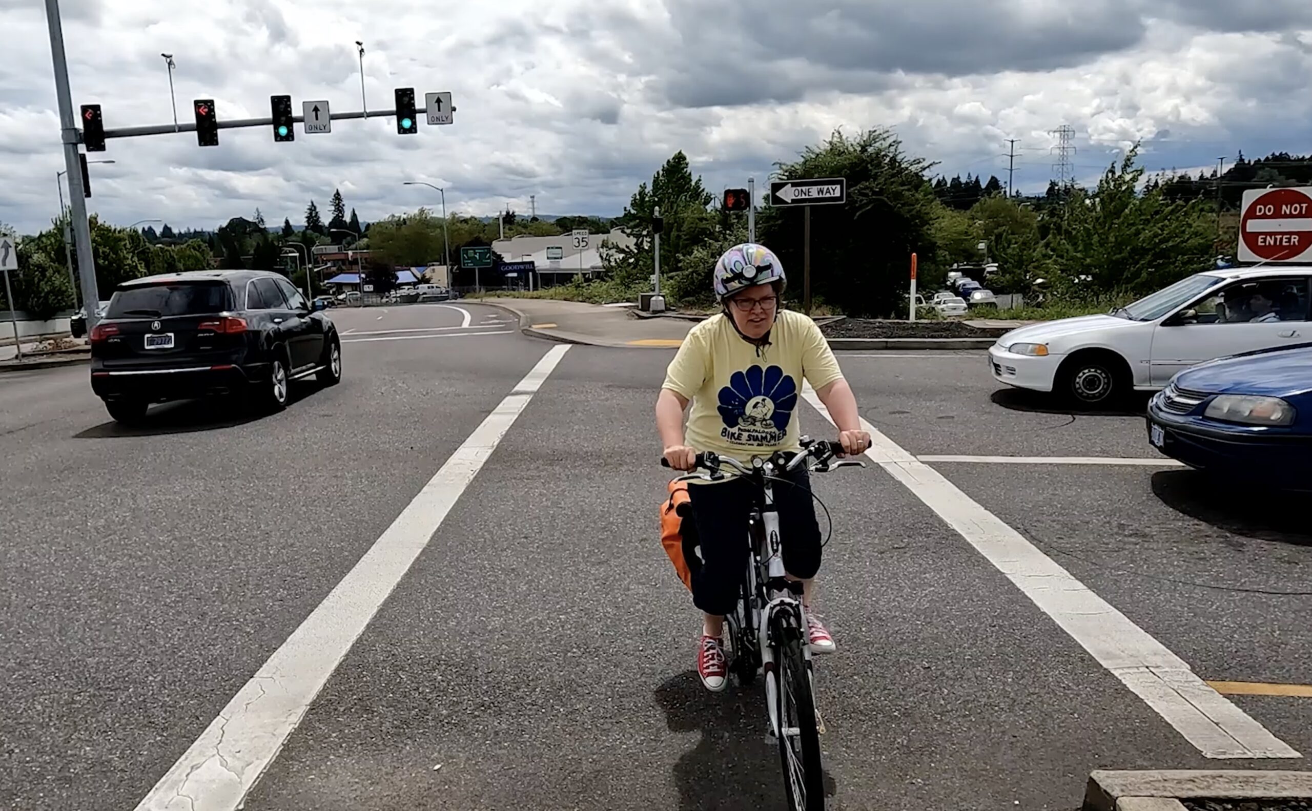
If not for a very small sign high up on a traffic pole, we wouldn’t know that the bike route is on a sidewalk going against traffic. (Tina said she’d biked this route for two years and had never noticed the signs until a County staff person pointed them out to her.) As we crested the Highway 26 overpass it was hard to hear each other over the roar of car traffic adjacent and below us.
Putting full trust of our lives into “Walk” signals, and after hitting six beg buttons and crossing four major intersections in the course of just a few blocks, we finally re-connected with the Waterhouse trail and could breathe easy again.
At Bethany and Cornell, Tina points out that crossing is prohibited for non-drivers at the southeast corner so we have to reposition our bikes and use painted crosswalks to get across the ten lanes of traffic, plus a slip lane. Cornell has a 40 mph speed limit and we feel like fish-out-of-water as we navigate our way across.
The Red Tape
Trail gaps are notoriously difficult to close for a variety of reasons, mostly because they’re often seen by governments as recreational facilities and not serious transportation infrastructure. In this case, Tina’s challenge is even tougher because of a nightmare of overlapping jurisdictional boundaries.
In just 3,800 linear feet between the two Waterhouse Trail access points the roads and intersections are owned and managed by three different government bodies: City of Beaverton, Washington County, and the Oregon Department of Transportation.
There has been some collaboration in the recent past, like when the County widened Bethany Blvd a decade ago, they got ODOT to sign off on (but not fund) the wider sidewalks we biked on. But as you can see in the video, even if the County granted Tina her smallest ask — pavement markings to help guide folks through the gap — County staff have told her they could only paint the sidewalk up to the overpass where ODOT’s authority takes over.
What Tina Wants
At the most basic level, Tina doesn’t want her 12-year-old to be hurt or killed while biking here. As she says in the video, she thinks at the absolute minimum there should be much better signage and markings along the existing route.
But that should be just the start. “I would love to see fully protected, Dutch-style bike paths so that a responsible parent would feel safe sending their middle schoolers to bike it,” Tina wrote in an email to one of the many government staffers she’s contacted about this. “So that all ages and abilities could ride the whole Waterhouse Trail, not just part of it. So that this could become a true transportation link as well as a recreational path.”
Tina, like so many other people in our region, is doing this on her own. She’s not connected to any advocacy group, she’s not being paid. She just wants to make .
“My experience with this whole project is that about every week or two of barking up trees, someone sends me a puzzle piece in the mail,” she shared in a recent email to me. “And I have to figure out where it fits.”
Watch our ride-along video below for a closer look at Tina’s project.


")
Thanks for reading.
BikePortland has served this community with independent community journalism since 2005. We rely on subscriptions from readers like you to survive. Your financial support is vital in keeping this valuable resource alive and well.
Please subscribe today to strengthen and expand our work.
Great story Jonathan! I really appreciate your coverage of this important gap in the off-street network. Keep up the good work!
Washington County and Beavertons idea of bike infrastructure is a painted bike gutters along a four lane 45mph arterial. I don’t know what it will take for them to shift their priorities.
Yes, agreed. However, the regional trails managed by THPRD are such a lovely exception to this rule… except for trail gaps like this one. I decided rather than starting with (waves hands) everything, I could focus on this one 3/4 of a mile section.
Thank you Tina and Jonathan, that was beautiful.
Whatever BikeLoud can do to support getting better infra here, we are in!
still safer to bike in washington county than mult co anyday
Might appear safer in the data because basically no one rides out there.
Not true – I ride in Beaverton all the time, and it generally feels safe, though I don’t love riding on the heavily trafficked 45-mph arterials. But they are better than nothing, and I like that Beaverton isn’t going for the wanded lanes which never get cleaned.
I’m trying to make it better. One 3/4 of a mile trail gap at a time.
Very helpful piece, Jonathan. The clarity of the article and simplicity of the needed solution makes it seems solvable. I must admit I find it amusing when people live in Beaverton and won’t stop talking about how horrible the traffic and bicycle infrastructure are. Often, it’s as if they moved there without ever visiting.
Actually, I’ve lived in Washington County since 1991. I’m well aware of the issues here. I have driven everywhere until 2018 when I started biking and trying to live differently.
Thank you Tina!
By coincidence, I just walked a 9 mile stretch of the Waterhouse trail (and a connector) a few days ago. I didn’t find the stretch over highway 26 to be that intimidating. It would be enormously expensive to build a connector over this highway and I would think there would have to be some synergies realized over just recreation to justify the expense (i.e. connections between Bethany and Max for cyclists)
I believe that gaps like this are a huge instance of “if you build it, they will come.” People don’t ride in scary places BECAUSE they are scary. But what happens if you make them less scary? How enormously expensive is it to NOT make connectors like this better, meaning everyone has to drive (or drive their kids all over) because biking is impossible? I started seeing gaps like this when I started biking to MAX from Bethany for my downtown job, two years before covid. It could be so good… for kids, families, and everyone, not just brave and bold adults. I think “justifying” the expense could mean building infrastructure that a responsible parent would send a hypothetical 12-year-old to use. If a 12-year-old can use it, then many others will too–older adults, timid adults, adult riders with baby trailers, and many others.
Hate riding through this spot. Also the raised path on the south side of 26 to rejoin the power line trail is slippery AF.
Yeah, the path isn’t great. It looks to me like THPRD is experimenting with a lot of different materials to make it less slippery when there is frost. The Bronson Creek bridge near me is really bad with frost also.
Go Tina! We just did this ride on Sunday on our way to tualatin nature park, and it’s the only dodgy stretch on what would otherwise be a wonderful, car free ride. What’s almost as discouraging as the danger is the sheer confusion involved in figuring out just how to stay on the trail. If the connecting route were clearly and prominently marked, I bet a lot more people would use it, but really, it needs a complete and coordinated redesign , as Tina advocates. Who should we contact at which agencies to boost her efforts? Email addresses would be helpful.
I ride through this section of WashCo relatively frequently, using parts of the Waterhouse trail to connect a longer loop of road riding through the area. Even for riders who are comfortable with riding next to 40mph traffic and taking the lane, it’s a dicey spot. Kudos to Tina for bringing a light to the gap and the issues it presents!
If only there was a wider right of way there could be a cycle track…. oh wait.
Too bad ODOT doesn’t have 1.5 billion burning a hole in their pocket, they could put down a little paint or maybe a bridge!
Excellent video! I felt ill watching the force salmon sidewalk riding!