“We wish this were not the case, however, it will give the City an additional year to hopefully implement bike detour safety treatments in anticipation of the Springwater Corridor trail closure.”
— Anne Nelson, Bureau of Environmental Services
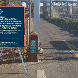
A project by the City of Portland Bureau of Environmental Services on the 170-acre Oaks Bottom Wildlife Refuge that was going to close a popular section of the Springwater Corridor Trail for up to four months next summer has been postponed.
In an email to stakeholders this morning, BES staffer Anne Nelson said the project will be delayed until summer of 2012 due to “funding issues”:
“While this is not our preference, it is the reality of the situation. As we are receiving a significant portion of the funding from the Army Corps of Engineers, the project must align with the Corps’ process and timeline, which is unable to align with our planned 2011 construction window.”
Also in her email, Nelson referred to concerns expressed by the City of Portland’s Bicycle Advisory Committee about the safety of the proposed detour routes. As we reported back in July, the BAC is concerned about maintaining safe and efficient routes for bicycle traffic while the key non-motorized transportation corridor is closed.
The Bureau of Transportation has made it clear that this project might be added impetus to improve several bike safety improvements in the area. Referring to those in her email this morning, Nelson wrote that the delay, “will give the City an additional year to hopefully implement bike detour safety treatments in anticipation of the trail closure…”
Learn more about the BES project here and stay tuned for more about the potential bike projects as details become available.


Thanks for reading.
BikePortland has served this community with independent community journalism since 2005. We rely on subscriptions from readers like you to survive. Your financial support is vital in keeping this valuable resource alive and well.
Please subscribe today to strengthen and expand our work.
Set up a bike counter at that location in 2011 during the originally projected closure months.
Use this to predict back logs to all important automobile traffic as cyclists are routed on to heavier traffic detour streets.
Also, with known increases in cyclist flow through known hazardous intersection we can easily estimate the increase in collisions.
Important factors in considering how and where cyclists will be rerouted.
Hopefully our political leadership is smart enough to leverage that sweet sweet Corps of Engineer money into more permanent bike infrastructure. Perhaps these “detours” need to be, say, permanent cycle tracks. Not that I’m holding my breath.
They’ll just find some other reasons to block the Springwater next summer anyway… sigh.
This is very good news especially for less confident (non-vehicular) cyclists if it means improvements in the bottle neck between Holgate & Insley (where there are no parallel neighborhood streets).
Not sure where a bike lane or trail would go however w/o removing northbound lane of car traffic on Milwaukie and southbound lane on 17th. Hey, why not?
There’s a fair chance this project won’t happen – 2012 pushes this into an election year, and there’s a good chance (unfortunately) that after the elections the environment for infrastructure projects will change – not for the better.
I think a cross-section like this could be good for NE Ainsworth. I love the trees, but those lanes are just so narrow that I think it would be worth reclaiming that median space for bikes.
Oops – my reply was supposed to be for the California CycleTrack story before this one. sorry for the confusion.