To make way for the Portland-Milwaukie light rail project, the City of Portland Bureau of Transportation is drafting a new Concept Street Plan for the South Waterfront district.
As part of that plan, some major changes are coming to SW Moody Ave. Among them are a new, two-way cycle track facility. Art Pearce with PBOT is heading up the project and he brought the plans to the City’s Bike Advisory Committee earlier this month.
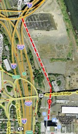
location of cycle track.
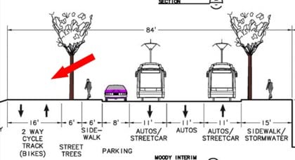
According to Pearce, the new cycle track will be 16-feet wide and will be built along the west side of Moody in order to minimize bike/streetcar interactions (see cross section drawing above). The cycle track will run between SW Sheridan Street (at the north end) and Gibbs Street (at the south end).
Also in the plans are to make Moody one-way southbound for all vehicular traffic through the District (streetcar would be one-way southbound south of Woods St.) and the street would be raised 14-feet in order to be at a level “consistent with the Willamette River Crossing Partnership findings necessary for light rail.”
City Council is set to adopt the new plan in July. After adoption by Council, they would direct PBOT to include the updated street plan into the next update of the Transportation System Plan.
More on the South Waterfront District Street Plan here.



Thanks for reading.
BikePortland has served this community with independent community journalism since 2005. We rely on subscriptions from readers like you to survive. Your financial support is vital in keeping this valuable resource alive and well.
Please subscribe today to strengthen and expand our work.
This will be great, as I come this way to work every day from the Hawthorne bridge. Moody doesn’t have a huge amount of traffic as-is, but the road is in fairly bad shape, and the bike lanes go over sewer drains and manholes and big potholes and such, so it will be nice to have some better surface to ride on.
Sounds good, as long as it gets me through that hellhole as fast as possible when I’m on my way to John’s Landing.
i’m concerned that pedestrians will cross the cyclepath… maybe this doesnt make sense. will there ever be retail on that side of the street?
A public open house is set for June 11th? Is that July 11th, or did the OH already happen?
Thanks for catching that Laura. My mistake. The open house already happened. — Jonathan
Jonathan, your ariel diagram is incorrect. The cycle track will be on the portion of Moody between SW Sheridan Street (at the north end) and Gibbs Street(at the south end). Since there will be no buildings on the west side of the street, there should be no conflict with pedestrians crossing the track.
Thanks for that Brian. I have edited the graphic and added info about where the facility will go. — Jonathan
The Southwest Corridor Path in Boston is very similar to that for much of the way, in that there is a sidewalk along the street and a two-way bike path away from the street. What happens a lot is that pedestrians walk in the bike path because it’s further away from traffic. It’s probably worth seeing if you can have just a very narrow strip of sidewalk for people getting in and out of cars, but put the “real” sidewalk on the other side of the trees, and maybe even on the other side of the bike path. Something like:
buildings – sidewalk – two-way bike path – trees – narrow sidewalk – parked cars – etc…
It’s a good thing that car is purple.
Now THAT is a cycle track…on steroids! The joggers with baby buggies will love it! I kid!!! I kid!!
It’d be nice to see that plan extend all along the willamette to Sellwood’s new crossing [picking up the new transit crossing and beyond to Lake O??]
Appears to be a good start and development appropriate.
If the cycle track is proposed on the west side of the street, the diagram is still wrong. can’t you get some better maps from PDOT, Jonathan?
Raising the surface 14′ will be a major and disruptive undertaking – how will traffic get through that area during construction? Cars can detour a number of different ways, but on a bike that’s the only reasonable option I can think of between SOWA / Macadam and Downtown.
Good to see Portland experimenting with separated bike lane implementations. I can’t wait to see more bike lanes getting people where they need to go on busy commercial streets, i.e. Hawthorne. One of these years…
@ben, I agree…. when will the city/pbot start planning for cycle tracks in areas of high cycle/auto usage i.e. Hawthorne, 82nd, Belmont, 39th, etc.?
While I love the idea of a cycle track, and fully support installing them, i think my tax dollars are best served by placing them in areas where they actually make some real impact.
interesting. on the surface, i like it… but 2 things…
1. what of the existing streetcar alignment “on” moody (single track, two-way, off-street to the west)? will this be realigned? it appears so, as the graphic doesnt mesh with my knowledge of the current alignment
2. mixing streetcar with car traffic AGAIN. argh. when will we learn to physically separate light rail from automobile traffic? as far as im concerned, this is the great failing of the majority of the portland streetcar line (excepting, ironically enough, the current off-street moody alignment) as well as the downtown max lines. light rail that has to share a lane with other traffic, even bus traffic, loses the advantage it has over such traffic. light rail stuck in traffic may as well be a freaking bus. this is just DUMB, and i do not understand why we keep planning things this way. all it takes is a slight elevation above the roadbed, a small curb, something like that. its SO easy, but it takes a willingness to relegate auto traffic to second fiddle in transit corridors, and we apparently dont have the cajones to do that yet. its tiring.
i LOVE that portland is spending time on bringing light rail back. LOVE it. every chink in the street i see with 30s era rails peeking through nags at me, so its great to see this stuff coming back. but while mixed-traffic light rail worked in 1930s era lower car ownership, its a huge mistake in this day and age. light rail and other public transit needs to be prioritized at the expense of auto travel if it is really going to find the chinks in its armor and exploit them. i realize moodys traffic is nowhere near the traffic the streetcar runs into on the rest of its route, but with all the development going on down there, it is likely to reach those levels in the future – and proper separation of light rail is one way to stave that off.
oh – and so as not to sound completely negative – im super-stoked on the separated cycle track aspect of this design. while i will likely still use the auto lanes for those times when i need to be down long macadam now now now on a rush delivery, the separated cycle track will make the other times a lot nicer. and while i wish this kind of alignment were being tried out somewhere more high-profile, i realize that its a lot more feasible to work this in in an area being developed rather than an existing zone. hopefully it can work as an example for other sections of town, though 6 years is a long time to ask those other areas to wait…
Small matter: on the west side, would it not be better to use the street trees to separate peds from motorized traffic rather than bicycle traffic? Admittedly the sidewalk on the west side will see little use as OHSU campus will be on the east side with the wider sidewalk. Unless there are development plans…parking garages…for the west side land up to I-5
So I have read a little bit of Jeff Mapes’ Pedaling Revolution. And he touched upon cycletrack streets, I believe referencing this project.
He spoke of a Mighk Wilson, the bicycle and pedestrian coordinator of Orlando who was not in favor of cycletracks. (p. 86 if you have the book)
Mighk mentioned that he thought it would be unethical to build cycletracks from merely the novelty aspect to encourage biking. This, I guess, because, due to the fact that there won’t be too many cycletracks in Portland, it would be a dangerous novelty to become used to?
Anyone want to perhaps take a crack at what this Mighk guy is referencing? I am at a loss.
I’m not understanding the raising of Moody by 14 feet. What is the purpose of this? And someone earlier mentioned that it will be okay for autos to bypass it – but, seriously – how will autos bypass this construction, considering there are two streets through the area, each going one way? Is the raising of the street only for the area where it’s two way, which is really only one block (right next to the OHSU building) unless you consider everything north of OHSU to be part of the “District”?
Why do these changes need to be made anyway? There is very little traffic through the area. I would support making Gaines a two-way between Moody and Bond (especially since I see cars driving the wrong way down that street several times a day). But the rest of it is fine.
I totally support the cycletrack though. That area is sketchy to start with, so anything that can be added there will be great.
The grade will be raised up to 14 feet in the north district only, i.e. the area between the Marquam and Ross Island Bridges where OHSU’s new campus will be built. This is to raise the land out of the flood plain and to allow for underground parking. Moody needs to be completely rebuilt and moved slightly west anyway due to light rail and to accomodate two-way streetcar on Moody.
The increased grade does not affect Moody street south of Gibbs (where the tram is located).
Will Portland cycle tracks come at the price of the right to ride on the road? Or does Portland have enough confidence in the design that it will still be legal to ride on the road?
There is an Oregon law stating that if there is a “bike lane” you have to ride in the bike lane – however, there are so many exceptions to it, I can hardly imagine it being enforced much in Portland proper. I’m pretty sure there are a good number of people who already violate this one (like the masses of people riding down Hawthorne off the bridge not in the bike lane) and never getting tagged for it.