Last night at the headquarters of the Sellwood-Moreland neighborhood association, about 50 residents showed up to learn more about the City of Portland’s plans to create a bicycle boulevard on SE Spokane Street.
They got a chance to see some of the latest innovations in the city’s toolbox for creating successful bike streets that co-exist with the livability and business needs of the surrounding neighborhoods.
Progress on this project is a welcome development from local residents. Over a year ago, the Sellwood-Moreland Improvement League (SMIL) sent a letter to the Bureau of Transportation (PBOT) endorsing the bike boulevard. In part because of that broad community support, when Sam Adams took over as mayor earlier this month, he included Spokane as one of three bike boulevard projects to be fast-tracked for completion by the end of the year (along with N/NE Going and N Wabash).
Funding for this $80,00 project is coming from two sources; $30,000 will come from PBOT through their Community and Schools Traffic Safety Partnership program (funded through traffic fine revenue) and the other $50,000 will come from the city’s Bureau of Environmental Services’ “Green Streets” program.
PBOT’s Mark Lear is helping spearhead the city’s bike boulevard effort. Reached by phone this morning, Lear said Spokane is a “key bike boulevard connection” because it connects the Springwater on the Willamette to the Springwater Trail and because it “has strong significance to the regional trail network and the bike boulevard network.”

because of it’s connection to
the Springwater Trail and its
proximity to Sellwood businesses.
Besides creating a comfortable and connected bike route, the city has two main goals with the Spokane bike boulevard; to improve the safety of the crossings at SE 13th and 17th and to minimize cut-through traffic on Spokane (thus making it a nicer place to bike).
In 2001, the city completed a major “road diet” project on SE Tacoma Blvd. (a major street that turns into the Sellwood Bridge, one block south). The result of that project was an increase in motor vehicle traffic on Spokane, especially during the morning commute hours.
To address the safety of crossing Spokane at 13th and 17th, Lear confirmed that PBOT will work with the Oregon Department of Transportation to create a new, 20 mph business district speed zone (ODOT must sign-off on any speed limit adjustments). Also proposed to improve the safety of those crossings is a 20-foot long pedestrian island, marked crosswalks, and new bike/ped signage.
To make the street less appealing for motor vehicle traffic, the Sellwood neighborhood is supportive of PBOT’s proposal for new diversion methods at SE 7th, 13th, and 16th.
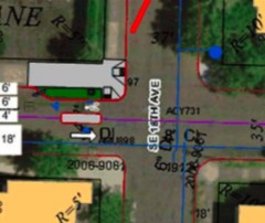
at SE 13th and SE 16th.
At 13th and 16th, the proposal is to install “semi-diverters”. These would be similar to the existing diverters on the Clinton bike boulevard at SE 39th. On that street, bikes get the exception to ride eastbound and they are separated from motor vehicle traffic by a double-yellow line (see photo at right). The new diverters proposed for SE 13th and 16th would place a concrete median between the bike and car traffic.
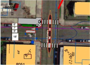
Another proposal for the crossing at SE 13th, that Lear said had the most support at last night’s meeting, was to add a full concrete median (with a pass-through for bikes, similar to SE Ankeny at 28th). That diversion method would restrict motor vehicle left turns off of 13th. (See below for concept drawing).
SMIL president Paul Notti is very excited about the 13th Ave median, saying, “I see it as being very positive for the neighborhood.”
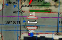
“pinch point” diversion concept.
At SE 7th, a new (for PBOT) and innovative “pinch point” method is likely to be built. The idea with a pinch point is to act as a “gateway” onto the bike boulevard and to ensure that bikes are not pinched into the shoulder of the road by motor vehicles. Two, semicircular concrete medians would be installed in the roadway, narrowing the width of the motor vehicle travel lane while providing a safe, protected buffer space for bike lanes on each side.
To further improve the biking experience on SE Spokane, PBOT will plan to flip three stop signs — at SE 9th, 11th, and 15th — leaving only the stop signs for the major arterials of SE 13th and 17th in place. In order to ensure that motor vehicle speeds don’t increase as a result of those flipped stop signs, PBOT has a contingency plan to analyze existing speed bumps and possibly add others (current speeds on SE Spokane average about 22 mph according to PBOT).
Another new treatment that riders will see on the Spokane Ave bike boulevard will be improved pavement markings. Every 300-350 feet or so, PBOT plans to lay down a new marking that will be significantly larger than the existing “dots”. According to Mark Lear, the design will be based on the existing bike lane symbol and will be placed directly in the roadway (stay tuned for visuals).
Also, because the Spokane bike boulevard is funded in part by the BES Green Street program, medians used in the project will be feature plants and bio-swales.
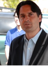
association president
Paul Notti.
SMIL president Paul Notti said one concern he wants to address during the process is that whatever happens to traffic on SE Spokane doesn’t negatively impact SE Nehalem and SE Miller. “We don’t want to just shift the problem,” he said, “we want to solve the problem”.
On the whole, Notti is enthusiastic about the project. He feels it will be a boost not just to biking, but to the health and economic vibrancy of the neighborhood. “I think this will be beneficial for people visiting Sellwood…beyond just bikers going through the neighborhood, it will have a huge impact on our businesses and livability.”
From here, PBOT will put together a refined proposal and meet with the board of the SMIL neighborhood association on March 4th. According to project engineer Scott Batson, the plan will then be turned over to the design team and the maintenance bureau would begin work on the project this summer.




Thanks for reading.
BikePortland has served this community with independent community journalism since 2005. We rely on subscriptions from readers like you to survive. Your financial support is vital in keeping this valuable resource alive and well.
Please subscribe today to strengthen and expand our work.
that would be SE Ankeny at SE 20th, not 28th. also SE Harrison at 20th.
This is all well and good but where’s some love and attention for outer SE. Whenever I find myself in Sellwood I find it a priviledge to not have to deal with SE Division or Powell. Why spend money where it is already better then some other areas? Outer SE needs a desperate overhaul!
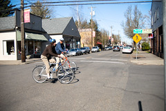
That first picture is actually crossing at 13th and Umatilla, but I am a former nostalgic Sellwood resident who spent too much time on that corner. What about the right turn only sign on the SE corner of 13th and Spokane? If the sign is still there this “alleged” 13th and Spokane photo would have caught these cyclists breaking the law!
Adam: I assume you mean east of 205, west of 205 there’s a really nice alternative via Woodward/Clinton (I used to live on 58th just north of Powell, Clinton to downtown was a really pleasant ride).
There’s not really a whole lot the city can do around Powell/Division east of 205. Take a look at the area on a map… none of the streets go through! The only alternative anywhere close by looks like Market, the rest of the streets go for three or four block stretches and then disappear.
I’m just using Google Maps to take a look at the area, I’m always happy to learn about alternate routes (just in case I find myself in the area), but to me it doesn’t look like that area lends itself to bike boulevards.
This is great. Crossing 13th or 17th can take a while, especially during rush hour. Traffic calming would help too since people coming off the bridge can be in a hurry although Sellwood itself is pretty chill.
Right now if you’re going between three bridges and the springwater on the river Umatilla is nice since it has signal buttons on those streets as well as a gentler grade.
Joel: the sign has been changed to right turn only except bicycles. Although it seems like only about half of drivers obey the sign. I nearly got _left_ hooked there going east today.
Whoops I mean going west.
I understand the need to calm auto traffic on Spokane because cut through traffic is very bad, but Umatilla (2 blocks south of Tacoma) already serves cyclist quite nicely. Umatilla also connects the missing Spring Water trail section.
This will be a good project when done, but I’d much rather see a North/South Bike Boulevard in Sellwood/Westmoreland. Someplace between 17th and 20th would be good.
“Over a year ago, the Sellwood-Moreland Improvement League (SMIL) sent a letter”
Come on…it’s the Sellwood-Moreland Improvement LEague (SMILE). Isn’t that better?
Matt M – I agree. North/South is key for connecting this neighborhood. About a year ago, I asked BTA about considering 17th as a future bike boulevard. Many cyclists use 17th or Milwaukie even though the car traffic is fast and close (scary at times). The current idea from city planners is to move N/S traffic down to the path which can be out of the way really. 17th cannot be considered as a bike boulevard because it gets too much traffic. Ironic.
In my commuting experience over the last five years, I haven’t had nearly the problem with speedy cut-through traffic on Spokane as I have on the other side of Tacoma, on Umatilla. Especially in the morning.
Cyclist (#4) I am indeed refering to east of 205. I to use either Clinton or Lincoln to find my way to downtown whenever I’m heading that way. I know from experience that Market is a quiet route to take but many times inconvenient. The major problem out here is exactly like you said. There are no side streets that go anywhere between Powell and Division. Seeing some improvements on Division and other major streets out this way would be amazing. Possibly some bike boxes along stretches of Powell. I doubt the possibility of this being that it is a highway.
Adam:
In addition to Cyclist’s recommendations, Bush south of Powell is a decent alternative. Getting to it is the main problem (and crossing 122nd). And Powell is really only viable once you’ve gotten East of 205. It’s not a good way to cross 205.
I commute using Division in the morning, when traffic is light (6:00 – 6:20am), but use Market on the way home. It’s a bit out of the way for me (I live a block S of Powell and 148th), but at least I don’t feel like my life is in imminent danger like it does on Division during the evening rush hours.
Anonymous / Adam? (#11) – Improvements to Powell are problematic because it is a state highway – everything has to go through ODOT, and PBOT can only influence ODOT’s decision – they have no actual say.
Outer NE and Outer SE are going to remain difficult to modify for bikes until we have real transportation money to spend – the city needs to implement expensive solutions to remedy the existing problems, like purchasing properties to connect subvisions, building sidewalks, signalization, and other pricey solutions. Painting lines and building minor traffic management treatments isn’t going to cut it in those areas.
This is fantastic and way overdue.
I’m really sick of people speeding down 13th like there aren’t people, kids, dogs, etc. all over and trying to cross this road.
And I’m even sicker of suburbanites from Clackamastan buzzing me on Spokane so they can shave 10 seconds off their morning commute.
Thanks for doing the peoples’ work, SMILE.
I think it’s great to add bike space. But I’m also very concerned that traffic will increase even more on SE Miller, when they already speed and don’t stop in corners especially in rush hour. SE Miller is wider than Nehalem making it a “perfect” speeding side street.
Just curious– but does anyone know why the Springwater Corridor bike path along the RR tracks in Sellwood does not continue along the tracks to 17th? For obvious reasons, this would be a mighty fine addition for those of us continuing south towards Miwlaukie (that little town south of Portland, ya know.)