
When Martin Greenough was hit and killed by a car driver as he rode on Northeast Lombard Street the night of December 12th 2015, he was very likely unaware of a dangerous gap in the bike lane where the busy highway rumbles under NE 42nd Avenue. Friends told BikePortland he had just moved to town and was still experimenting with his route to work.
Now, nearly a decade after Greenough’s death, the City of Portland and Oregon Department of Transportation are ready to close that gap for good. BikePortland shared this news in 2021 (after local traffic safety activist and lawyer Scott Kocher told us about it) and the agreement between the city and state was finalized last year.
A Portland Bureau of Transportation project manager told members of the city’s freight committee at their monthly meeting last week that they’ve received funding from ODOT (who owns and manages Lombard since it’s also Highway 30) to widen the road and build a continuous bike lane in both directions. The PBOT staffer referred to this as a “vital safety improvement.”
The work is part of PBOT’s project to replace the 42nd Avenue bridge later this fall.

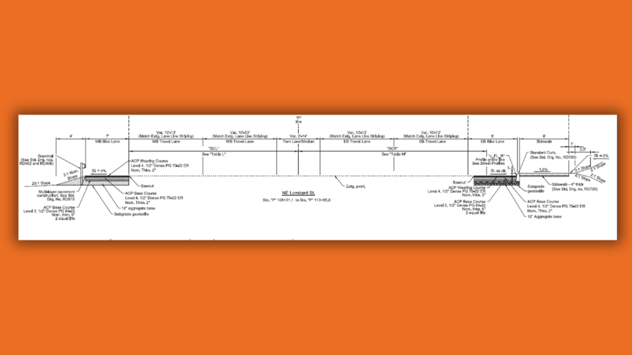
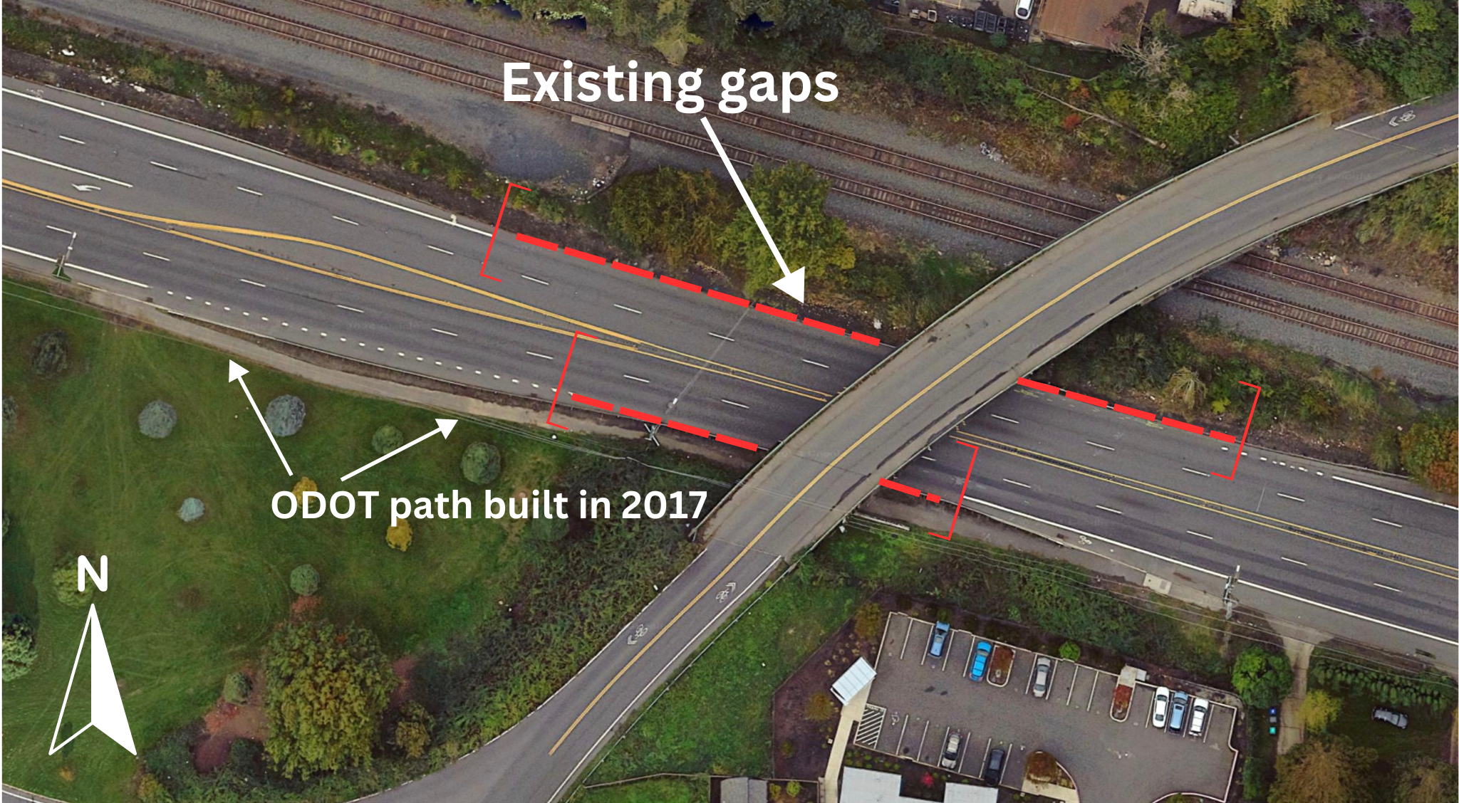
PBOT Public Information Officer Dylan Rivera has confirmed they will stripe a seven-foot wide bike lane in the westbound direction and an eight-foot bike lane eastbound. Rivera says ODOT gave PBOT $587,000 to build the new bike lanes. The lanes will have a paint-only buffer stripe. The schematic plans shared by Rivera (above) also show an eight-foot sidewalk on the south side (eastbound) of the street. I assume this will take the place of the existing bike path, but I still need to confirm that.
In 2017 the city and state settled a lawsuit with Greenough’s family over the design of the roadway. At that time, ODOT opted to pave a bike path in the eastbound direction, instead of closing the bike lane gap.
The Greenough tragedy pressured the City of Portland to edit their official bike map to reflect the dangerous gap. Once the new bike lanes are in place, they’ll have another change to make to the map. Whether an unprotected bike lane on an urban highway with a 45 mph speed limit merits removal of “caution” markings will be up to PBOT.


Thanks for reading.
BikePortland has served this community with independent community journalism since 2005. We rely on subscriptions from readers like you to survive. Your financial support is vital in keeping this valuable resource alive and well.
Please subscribe today to strengthen and expand our work.
Hopefully not, but I really don’t like how inconsistent the “caution” markings are. Let’s take a sample of them to see just how hard it is to know the conditions on the road.
I find it incredibly frustrating to go over things like this. There are clear and obvious categorical differences between a place like NE 28th for riding and a state highway with a disappearing bike lane under an overpass, or a wide arterial with no shoulder. If someone rides a lot on NE 28th, then consults the bike map to see if a route will be safe or not and uses that as a heuristic for what “difficult connection” means, will they end up riding uphill on NE Glisan in 40 mph traffic with no other option?
It’s hard not to feel like some of the decisions for how to categorize certain segments have more to do with the history of how the greenways and other bike infrastructure came about. Is NE 28th labeled as a “difficult connection” because it’s difficult, or because PBOT wants to encourage use of the less direct “20s” greenway (on 30th)? And is the bridge over 99E labeled as a “difficult connection” because of the presence of the relatively new SE 17th bike lanes, or because it’s genuinely dangerous? I ride that bridge at least once a week and prefer it massively to waiting at the at grade crossing of 99E and 17th. And on 12th, before the Blumenauer Bridge was built, the crossing was just marked as a standard “bike lane” with no difficult connection included (source). Sure, these days of course I’d rather ride over the Blumenauer, but there are still times when 12th is more convenient for me and conditions are exactly the same as they were before the other bridge opened.
This is all to say that the bike map has serious flaws, but they should be fixable. Places that are more in the “sort of uncomfortable” category (NE 28th, NE 12th) really should not be marked as difficult connection when the same designation is used for segments that are almost always going to be immediately life threatening. It’s confusing and dangerous for there to be such glaring inconsistencies. If PBOT can create a whole new part of the legend for “Shared Roadways” to make the bike network more complete looking and legible (but which really amount to nothing at all), then they can have a category for “use extreme caution very dangerous”.
IMO, PBOT marked these areas as RED (danger!!!) only because they wanted people to switch from these older but still widely used bike routes to the 20s Neighborhood Greenway and the Blumenauer bridge.
This incorrect red-zoning of commonly used bike routes is just the PBOT bike map version of a motorist shouting at you that you should not ride on Hawthorne/28th/12th but on the Neighborhood Greenway a few blocks over.
Or the insane amount of turns they added to the new 70’s greenway path, it used to be down a nice straight road
It makes me maybe unreasonably angry that the 70s greenway is routed on 80th when 76th is straighter and has the crossings for Division and Powell. There’s only one major road crossing where 80th is better than 76th (Stark). The only benefit to 80th is to provide a closer parallel facility to 82nd, which is almost certainly the reason for the routing.
But then when you interrogate that further, it’s hard not to feel like the purpose of the 70s greenway is to make it so PBOT doesn’t need to bother with bike lanes on 82nd. I don’t think there’s any specifically bad intention from PBOT on this front, but it is a natural consequence of using greenways as parallel facilities for major roads. There usually aren’t great options for this (part of why the major road is major in the first place), so you get a windy, contorted greenway rather than a natural low-stress route through an area.
I think the problem is that a greenway can kind of only do one or the other – it can either be a parallel facility for a major road, or it can be a relaxing neighborhood route on a natural bike route. There are exceptions (Ankeny, Clinton), but the further out from the central Portland grid you get, the more difficult it is to find neighborhood roads that do both aspects of a greenway well. And of course, N/S routes tend to be much more difficult than E/W routes in this regard as well. There really only are a few car routes that manage to go N/S in Portland without chicanes and seemingly random turns. The fact that 82nd is one of those (along with MLK and sort of Cesar Chavez) and won’t get bike facilities in a major rebuild is a major issue, and one that is not solved by giving cyclists a circuitous detour.
blumdrew just posted the c.omment of the week.
This is good news. Tragically, it comes a decade too late.
It amazes me how much infrastructure upgrades cost. Half a million to widen, stripe, and build sidewalk on a ~ 100′ stretch of road? Ludicrous.
Are the columns that support the 42/47th overpass going to be moved? Because it seems like their existence is the reason the nominal bike lane that now exists has a gap. The cross-section shown above (the text of which I can’t make out) seems to show two more sidewalks, two more bike lanes, and a left-turn lane (purpose=??) compared to the existing road. There is certainly not enough space to do that between the existing pillars. If the overpass is going to modified, what do the modifications look like? Will they improve bicycle connections to/from the Holman greenway? I certainly welcome completing the shoulder bike lane on Lombard, but 42/47th is a higher priority to me.
Also, it’s frustrating that it takes a fatal tragedy plus years of litigation to impel ODOT to meet the barest minimum to make bicycling on Lombard survivable.
The NE 42nd bridge is being completely rebuilt. The columns of the new bridge will be set wider so that there’s room for the new bike lanes and sidewalk.
With the construction of the paved path, why is there a gap in the eastbound direction? That bypass is probably the safest part of the route.
It’s unclear to me what the street profile will look like after construction (e.g. they closing a lane or routing around the bridge piers?), but I’m glad this gap will finally be addressed.
Good question Watts.
I don’t consider paths like that the same as a bike lane. The “gap” still exists because the bike lane ends and then picks back up a bit later. That path is OK, but it’s often blocked and it’s not really the same as an on-street facility. Also, it is only in one direction.
And given the high probability that the bike path will be blocked by *something* in the near future, I would consider this to still be a gap, as I won’t be able to predict on any given day if it will be clear or not.
This is stupid. It’s not the car cultrue that is the problem, it’s the bicycles riding in the middle of the street instead of the sidewalk. Bicycles do NOT BELONG IN THE STREET!!!As long as they keep making streets worse for cars in favor of bicycles, bicycles will continue to be hit by cars driving where they are supposed to. Portland is ***portion of comment deleted by moderator for inappropriate word choices. – JM***
Look at the picture at the top of this article. Someone is trying to ride their bike to a job on the other side of this gap. Where should they ride? And “get a car” is not an acceptable answer.
I’ll wait.
NE Holman/Ainsworth/Killingsworth? It’s where I’d ride, with or without the westbound gap being filled.
Not nearly as direct and with significantly more crossings. We should have direct/fast routes in this city. I don’t think we should treat every major road like it is a limited-access interstate.
Sure, but the bike lanes as designed on Lombard aren’t exactly safe even if this gap gets filled. They’re just repurposed shoulders, and ODOT would never allow for them to be hardened because they still function as such. We could push for a separated path (probably north of the street and south of the railroad) instead, but no idea if that’s actually worth it.
There are places where I’d push for fast/direct routes, I think this particular section of Lombard is super low priority given how few places there are along it, and how its owned by ODOT still. Better to push on 82nd, or Hawthorne, or MLK, or E Broadway, or Sandy, or Belmont, or Cesar Chavez.
It sounds like they plan to invest over half a million dollars and the end result will still be a death trap that few will want to ride on and really no one should want to ride on. Am I missing something here?
Don’t ride on Lombard, period. Plenty of better routes. Spend limited money in east Portland and Cully to build sidewalks.