(Graphic: PBOT Citywide Bike Map)
The City of Portland has edited a section of their official bike map to more accurately depict a dangerous gap in the bike lane where man was killed in 2015.
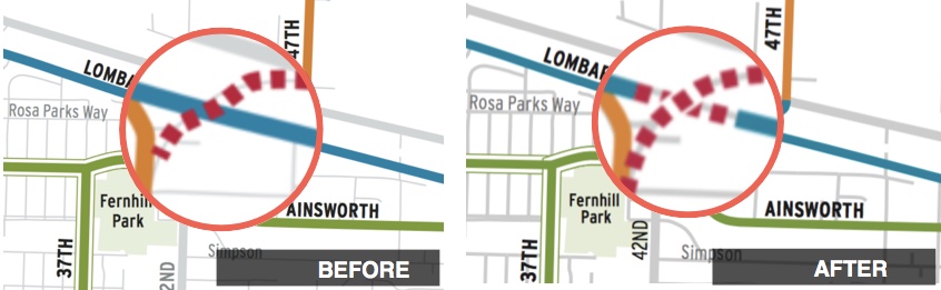
As we reported at the time, Martin Greenough might have been on his first-ever bike commute when he was hit and killed by an intoxicated driver on NE Lombard. Greenough was hit while bicycling through a dangerous gap in the bike lane that occurs where the lanes narrow to go under an overpass. Unfortunately, the official City of Portland bike map Greenough used to plot his course did not show the gap. The map incorrectly labeled that section of NE Lombard where it goes under 42nd Avenue as having a continuous bike lane.
After consulting his map, Greenough probably assumed his chosen route was safe. By the time he realized he was wrong, it would have been too late to change course.
In response to our reporting, Metro edited the online version of their “Bike There” map 10 days after Greenough died. That map also labeled Lombard’s bike lanes as being continuous. Metro’s edit added a red “bike with caution” label to the entire gap where Greenough was riding.
Advertisement

On December 23rd I asked if the City of Portland would edit their map in a similar way. I never heard back. This week I just happened to look at their map again and noticed the change. Both the printed and online versions of PBOT’s map now use a red “difficult connection” label in the Lombard gap. The change was made sometime before March of 2016.
Greenough’s family ultimately sued the City of Portland (and the Oregon Department of Transportation) for their negligence in allowing the gap and pinch-point to exist and failure to, “provide for safe travel for both motor vehicles and bicycles.” That lawsuit settled last month.
Today ODOT is putting the finishing touches on a new path that will finally close this dangerous gap in the eastbound direction. But PBOT doesn’t need to edit the map again because there’s still a gap for westbound bicycle traffic. When ODOT finishes upgrades to bicycle access in both directions, we hope PBOT will edit the map again.
Someday when our bike network is upgraded and completed we won’t need to rely on maps to keep people safe. Until then, the maps we have must be as accurate as possible.
— Jonathan Maus: (503) 706-8804, @jonathan_maus on Twitter and jonathan@bikeportland.org
BikePortland is supported by the community (that means you!). Please become a subscriber or make a donation today.


Thanks for reading.
BikePortland has served this community with independent community journalism since 2005. We rely on subscriptions from readers like you to survive. Your financial support is vital in keeping this valuable resource alive and well.
Please subscribe today to strengthen and expand our work.
Wow, Portland, over a year to make a tiny correction that could save lives, and not even a differentiation between eastbound (now much safer) and westbound (still deadly despite *MASSIVE* room for a side path). Faint praise: thanks for finally doing it.
Thanks for the followup, Jonathan. (not faint praise 🙂
Thank you for this article.
Even as a fair weather bike commuter, it has always been a constant that the organizations responsible (e.g. PBOT, City of Portland) for these issues lack accountability and integrity and that will continue to be the case until significant changes are made.
I checked the map for a few of the unsafe intersections/connections I know of and it looks liek none were added to the map. I think PBOT has too high of a bar for what makes a dangerous Intersection/connection (requires a high profile death). I am glad that they made this cahnge and I think it is very important to provide good information, but it is disappointing that PBOT seems more concerned with creating a map that touts miles of bike lanes/greenways than creating a map that would be useful tool in navigating the CIty by bike. This does not bode well for the prospects that the City will tackle and fix the numerous dangerous connections, intersections and gaps that would make true, functional network out of the disparate lines we have today
” This does not bode well for the prospects that the City will tackle and fix the numerous dangerous connections, intersections and gaps that would make true, functional network out of the disparate lines we have today”
My impression is that there are serious, dedicated folks at PBOT who would be pleased to get this right, fix the maps, or better yet the problems themselves. But I also believe that the honchos and the money bags don’t dispense authority and funds in accordance with these sensible priorities I’m imputing to some of the staff. How can we fix this?
Find a transportation advocate who can win a council seat.
The city could overlay the map with their crash statistics that they use for vision zero. This would give people a more complete idea which areas are safe and which ones are not.
Yes this is good news…even as long as it took for this oversight to be corrected. Sadly, it took a life to highlight it.
Thanks Jonathan (and others) for keeping an eye open for this correction…I wonder if Google bike mapping updated itself too?
a death you mean?
So many maps have bad bike routes or don’t even show gravel trails in the urban city. Check SW Sunnyhill Lane in West Slope. A nice route to downtown Beaverton.
So, it seems that ODOT could add a similar “behind the columns” fix in the westbound direction, too. But, they’d have to build a 3′ retaining wall to hold it up. Apparently that’s too expensive, so the westbound route will continue to be dangerous until…..
doug, I think ODOT is working on the westbound direction. I’ll try to get an update and post something.
I drove by on Lombard westbound today. No sign of work on that side. The bike lane still disappears as the guard rail and curb squeeze over toward the motor vehicle lane. It’s a very dangerous location.
The eastbound bike bypass looks good (what I could see from the far side of the road).
Jonathan —
Thanks for bringing this to the attention of Metro and PBOT.
Metro and PBOT’s maps have dozens, if not 100s of other errors like this in them.
I’m surprised that, given the large numbers of bicycle commuters in Portland, that neither PBOT nor Metro seem keen on reviewing their maps in-house to get errors like this fixed, and reduce the number of people on bikes that are unnecessarily going through dangerous or grueling sections of road.
I sent in some corrections to Metro over the years, and it took a long time for anything to get corrected. But very serious stuff, like the southbound MLK bridge over Columbia Slough, which is marked as having bike lanes, but in real life it’s a 55 mph highway with exactly zero shoulder, on a bridge…
https://goo.gl/maps/oowqVBegBvm
https://goo.gl/maps/fqPo6QNpdcE2
I sent in the correction request in in May 2010, not sure when it got corrected, maybe 2015? (I could be wrong on this, I don’t have current or old paper copies of the map handy) At any rate I’d never seen it corrected until I checked tonight.
I try to be motivated to help out and send in corrections like this. It could save someone’s life. But I find it hard to be motivated with the very lukewarm response rate from the government agencies.
I’d think they’d take these issues more seriously…
Ted Buehler
I’m surprised so many people would put that level of trust in a map.
Cycling maps sometimes make dangerous roads look safe and vice versa. The technical details that the maps are based on present only a partial picture and don’t account for specifics unique to the area or moment.
Maps are a good first point you turn to if you don’t have another source of information, but they’re no substitute for judgment.
You have to put some level of trust in a map. Most of us here have spent way too many hours poring over maps, just to figure out safe routes across town. What would be nice is if all (or most?!) of our streets were safe, so we didn’t have to do that.
But ALL of us have been in the situation where we found ourselves on a road we thought was going to be safe, and turned out not to be. Sometimes we backtrack and go another way. Sometimes we’re pretty committed, and backtracking would take us miles or even hours out of our way. Heaven knows I’ve found myself in this situation on roads like Lombard, or worse, many times. So we cross our fingers and pray. It almost always turns out okay, with nothing worse than a bad scare. Unfortunately it didn’t for Mr. Greenough. That’s just unfortunate luck, not putting an excessive “level of trust in a map.”
This is true, but you have to make the right call if something is genuinely dangerous, even when significant inconvenience is involved. I don’t like bailing out on routes either, but you have to do the right thing.
In the case at hand, Mr. Greenough was especially unlucky. While I don’t like that section where he was, I do ride it occasionally and consider it one of many dicey areas where you have to reach into your bag of tricks and be especially alert.
There’s only so much you can do against high, speeding drivers and many people use bike lanes for acceleration/deceleration. Even when everyone is sober and driving the right speed on a busy highway, you can count on everyone to pull over while looking behind at an ambulance blaring its siren and not at the cyclist ahead.
Whenever there’s a disaster, there’s a tendency to identify some sort of trigger and focus on that as the cause. The reality is that in almost all cases, many things went wrong.
Kyle,
If the maps simply showed suggested bike routes, then I would agree: proceed with caution and use your judgement/be prepared for anything. These maps purport to show difficult connections and dangerous intersections. That is a totally differnt type of map and is, in fact, dangerously misleading.
Agreed. I did look at the maps when I first moved to the area. I quickly found enough issues that I personally don’t trust them for more than a general idea of what might be a good idea.
True. Whenever I give someone one of these maps I take the time to explain that just because streets may be marked with the same color does not mean you’ll have the same type of experience on each one.
Johnathan, who do we contact at Metro to update the “Bike There!” map. It has some errors that are hard to believe made it into the map. For example, it shows a section of trail along the Waterhouse trail between Bethany Ct and Mission Oaks Dr that doesn’t exist. It also claims that there is a “established bikeway” through John Marty Park, despite the paths being 5ft wide and lacking curb cuts at four street crossings.
Is the current edition of the Bike There! map showing this? I have the 2014 version online (in the Bike Maps app) and it doesn’t show such a connection. It does show one connection from Mission Oaks to the Willow Creek Trail (via the powerline trail, although Google Maps also shows 4 additional connections to the Creek from Mission Oaks cul-de-sacs). But it definitely does not show a connection north from Willow Creek to Bethany Court (which, I agree, would be a nice link if it existed).
I do find that in general, bike maps are rife with errors or simply hopelessly out of date all too much of the time. So many of our bikeways in the Twin Cities – even some that are a few years old already – are missing from Google Maps that I haven’t even bothered trying to submit updates, as I did a few times when I was in Portland. I’ve been meaning to, but ugh … such a big job, even just for my part of town. Maybe one of these days I’ll start keeping better track of the errors and submitting corrections. The process, at least for Google, is really easy.
I don’t have the print version, but the online version does have it: http://www.oregonmetro.gov/tools-living/getting-around/bike-there
Thankfully it is at least planned. I think it’s supposed to start construction in 2018.
I find the whole premise here to be, well, complete garbage.
I have a similar situation around here where there’s no room for a car and a bike. If you’ve ridden STP you’ve ridden it. The railroad bridge on the Cowlitz River just west of Kelso. There’s no room for a bike and a car so if one’s coming I stop and wait for a clearance. It’s 45 mph there so it’s a little dicey in busy traffic. I adapt.
The victim should have done so and blaming the map just seems like the typical scapegoating that is so common on this site. Can’t anybody take a little responsibility for their own safety? If he was uncertain about the route’s safety he should have driven it in a car. If a non driver hire an uber. I just get sick of the god damned excuses. Everybody’s got one, they all stink.
I’ve got 10’s of thousands of miles riding and I don’t care if I have bike infrastructure or not. If I don’t like a road I stop riding it, pretty simple, silly map dots or not.
Whoa!
I’ve done a lot of riding myself over the past thirty five years, and like you I’ve gotten used to no special infrastructure………. but…. that doesn’t in my mind justify the angry disdain you exhibit for those who are less road-wizened. Seems like maybe a little compassion for all those who are not so comfortable or familiar with the tricks you and perhaps a few others have mastered.
This part I find particularly tough to swallow:
“If he was uncertain about the route’s safety he should have driven it in a car. ”
Excuse me? We have here a bike blog where we proudly defend and work toward the right to bike most anywhere. That bit of Car Head that snuck into your post doesn’t seem that useful or productive.
Inferring emotion from written text is a mistake.
not always.
I agree, it seems like an elitist comment. Mr. Greenough was, from what I understand a newcomer to bike commuting. There are already a lot of barriers to entry for casual or neophyte cyclists, and we need to reduce them. Unsafe roads – and failure to document them as frequently as possible – contribute to making casual cyclists scared to ride more. Whether or not you think the map contributed to his death, I think we can all agree it *should* be updated.
And let’s remember, this is a situation where the road HAS A BIKE LANE, AND THEN IT DISAPPEARS. No suggested detour, either in the real world or on the map. I haven’t actually ridden Lombard – is there even a bailout option before you reach this spot, or does it just disappear without giving cyclists an option?
There was a time when I would have wondered why a cyclist wouldn’t just check behind them the entire time they were in this area. After all, that’s what I do when I am riding in these kinds of gaps. Then my partner mentioned that he doesn’t because he’s afraid to fall down. I didn’t even know that newer cyclists might think along those lines. So the disappearing bike lane would be especially dangerous for a newer cyclist.
I had my eyes opened along these lines a few years ago when a bunch of my coworkers decided to try bike commuting. One of them had never ridden a bike as a child and not that much as an adult either, and expressed similar fears of falling down – scared to even look in a mirror, let alone looking back over the shoulder.
I checked that out. It looks like a gravel section, 1/2 block long running east to west. How does that lead into Downtown Beaverton?