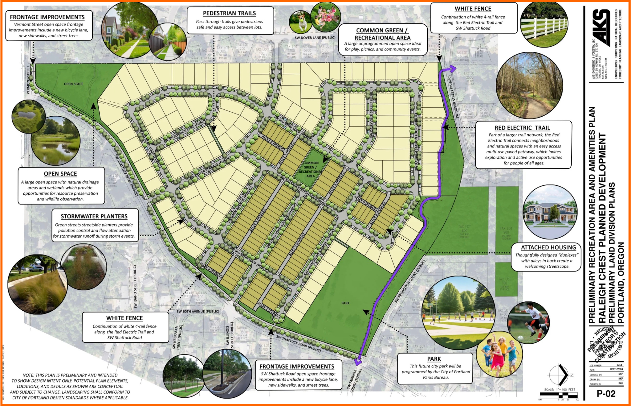
The Hayhurst neighborhood association presented preliminary plans for development of the Alpenrose Dairy site last week at their March 11 open house about the property. The group obtained the draft plans through a public records request, and shared them at the neighborhood meeting and with BikePortland.
The 51-acre Alpenrose campus holds special importance to cyclists because of its Velodrome, which closed permanently in 2021 after 60 years of operation. But it was also home to an operating dairy, Little League playing fields, and a faux frontier town. So overlapping communities have strong feelings about the future development of this property, including the neighbors who live closest to it in southwest Portland.
I have been keeping an eye on the plans because new development is the main avenue through which southwest Portland is supposed to get bike lanes and sidewalks. But because most of the southwest lacks a formal stormwater conveyance system, the city often only requires developers to fulfill frontage improvements in a rudimentary way. What I have been waiting to see is if development of the Alpenrose property would bring a safe place for pedestrians and cyclists to travel along SW Shattuck Road, the two-lane collector which fronts the site to the east.
According to these preliminary plans, the answer is yes, and that is a very pleasant surprise for me. In the cross section below, you can see a design for a multi-use path separated from the roadway by a “stormwater facility,” and also a curb.


Keep in mind that this has not been approved. The permitting log on PortlandMaps shows that the Portland Bureau of Transportation (PBOT) and the Bureau of Environmental Services (BES) each approved a “Concept Review” with corrections on March 12th. [UPDATE: 3/22/24 9:20 — the permitting log actually says “Approved w/corr,” I assumed the “corr” meant “corrections” but it could also mean “correspondence” or anything else that fits.] Hopefully the MUP isn’t something which will be corrected away. And, to be honest, I am confused about the process. The preliminary plans are quite finished, and are much more detailed than I would expect to see given that there doesn’t seem to have been a Public Works Alternative Review (PWAR) meeting. My limited experience is that a developer doesn’t go forward with the expense of a detailed plan without knowing what the city expects to see.
I put in a public records request to BDS last week for any recent PWAR forms and was told that PWAR was a PBOT matter, and that PBOT hasn’t “yet received the Public Works Alternative Review for this location.” My understanding from Marita Ingalsbe, president of the Hayhurst Neighborhood Association, was that the developer intended to file plans in mid-April.
A mid-April filing doesn’t leave any time for the back-and-forth a PWAR often entails.
So I don’t know exactly what is going on, except that stuff is going on and, knock on wood, things seem good with the Shattuck frontage. I am not going to follow-up with a flurry of further public records requests (for example, for the “corrections” to the concept plan, or trying to time when PWAR forms will arrive at PBOT). But things are happening and perhaps we will have firmer information in the near term. Stay tuned and please contact me if you have any information to share.


Thanks for reading.
BikePortland has served this community with independent community journalism since 2005. We rely on subscriptions from readers like you to survive. Your financial support is vital in keeping this valuable resource alive and well.
Please subscribe today to strengthen and expand our work.
I just uploaded the PDF of the preliminary draft plan, linked to from first paragraph and here’s the URL: https://bikeportland.org/wp-content/uploads/2024/03/Alpenrose-PreConcept_Meeting_Exhibits.pdf
I have been thinking about the idea a lot lately of instead of building another subdivision of houses like this, which is a really expensive, inefficient and resource intensive way of housing humans, it would be kinda cool if they built like a really nice 2 acre sized mid-high rise in the center of it, and then the rest of the property could be a beautiful natural space with community gardens and trails and trees all around it. I know a lot of people bristle at the idea of tower buildings, but I think that’s because we don’t build them in a way that really facilitates an awesome life with a vibrant community.
Oh Jack, you make me laugh, I was thinking the same thing–a sixty-story tower smack in the middle of the cow pasture. Five units a story and you could get 300 units! I just don’t think there is a market for it in the middle of 52 acres of rolling hills.
That was the concept the French architect/planner Le Corbusier pushed in the 1920s–towers surrounded by park space. It was the opposite of Frank Lloyd Wright’s concept of single-family houses on large lots sprawling forever.
The tower idea does make sense on some levels. There are lots of European examples of mid-to-high-rise residential towers, allowing density with more open space. On the other hand, the tower(s)-surrounded-by-open-space idea was also the inspiration for the infamous “projects” of 60s, which isolated people (especially children) stories above the ground, turning it into dangerous no-man’s land.
A true mix of housing would be awesome – SFRs, duplexes, one or two 3 story apt/condo buildings with ground retail or community center. Not gonna happen but duplexes are planned for a future date at least.
Yes. The proposal is pretty lame. It would look really grim if they hadn’t done what every landscape architecture student learns in school–the most mundane site plan looks a lot better if you add a bunch of little green tree circles with little shadows everywhere they fit.
It does have some open space at the outskirts, and a common green that’s so small it’s token. It would create much more of a community if the apartment buildings you suggest were added, and organized around a larger central open space. The density would be the same or greater.
That number of housing units could support a cafe, a bodega, and/or a produce stand. A link to a viable regional trail could help support those businesses. If there’s no internal commercial space that sort of implies that people are driving everywhere for things they need.
It’s possible, maybe even likely, that Portland Parks will include some community garden space in the dedicated park area. Parks is going to want motor vehicle access anyway since that’s how they do maintenance.
If we can believe in the street cross sections there’s at least some provision for pedestrian and bike rider access.
Isn’t this a bit like S Waterfront? That place feels a bit sterile to me, but I don’t know how it is to live there.
Welcome to Prague!
Remember that our system is bought and paid for by developers, so it’s not really about providing the housing people need – it’s about providing housing that makes money for developers.
An alternative lens to view this is that our housing system is about providing houses that people will want to pay for individually rather than collectively determining what they will get. The old conundrum (canard?) that splits Europe and America.
And there are a lot of reasons to think a single family home is a better investment. After all you are deeded a piece of land rather than a share in an ownership vehicle that owns a building and some land.
Certainly Pearl district condos have been an utter disappointment in terms of holding value.
However, having gone through this recent storm and had to replace all my pipes, I wonder if a condo is actually more expensive. The thing with a house is that you have control over the repairs and who does them.
All good points, donel, but real estate in the USA has become an investment vehicle that drives all kinds of decisions at the federal, state, and local levels.
We – the consumers of housing – don’t have much or any control over the forces that drive the larger decisions about where housing is developed, how it’s developed, etc.
The “SW Shattuck Road Typical Cross-Section” only makes sense if something is clipped on the right, since only one car lane is shown. And the other diagrams are too small to read.
I’m sorry to read that “I am not going to follow-up with a flurry of further public records requests” since those will further reveal the plans.
Mark, anyone can make a public records request, go for it. I might send a request for PWAR request and decision forms to PBOT in a couple of weeks … it just didn’t seem worth my effort right now. You realize you can click on the image and they get bigger? Should take care of that right travel lane.
I’ll see if I can get JM to swap in the PDF for the page with multiple cross sections on it.
Thanks, Lisa, for staying on top of the plans for this MAJOR development in SW Portland. We won’t see another development like this in our lifetimes, as it’s the last large undeveloped parcel in SW.
A couple of thoughts:
Thanks again for the good reporting. Kinda ridiculous that the NA has to file a public records request and the city isn’t more forthcoming with information that directly affects all of us.
All good points Fred. I would think the Shattuck improvements would be paid for by the developer. I was happy about the Red Electric too. If this all goes through, that will be a good start to a family friendly network, up Shattuck to Red Electric and then 17 miles of easy riding. I’m hesitating to put to much more effort into this piece until what is on the table is more certain. But right now, it looks like 270 units gets the city a new MUP.
Also, they will be doing a traffic study of relevant intersections, you can see the specs for that on the PortlandMaps permitting page.
I’d really prefer to see more density and a little commercial mixed in. Get a corner store and coffee shop, etc in there.
Is there any MUP connectivity to the existing community and RET? The only obvious exits in the design appear to be typical driveways.
Mike, I just uploaded the PDF of the draft plans, linked to it in first paragraph. You can see everything in more detail in that.
SW Dover Lane should not be punched through to the Alpenrose property on the county line. At the Multnomah / WashCo line on both NW Ash Street and NW Copeland Street, there aren’t punched-through car streets. There are blockades there to prevent thru-car traffic. An emergency gate should be placed to be prevent thru-car traffic. Also, the new Red Electric Trail should have an entrance from SW Dover Street from more than one place. The current design forces people on bikes going westbound to quickly slow down a steep hill; instead, make a second entrance at the top of that hill.
Where is the steep hill exactly?
The top of the hill is at 6403 SW Dover Street in Portland, Oregon. That is where a second entrance is needed for the trail? Why not make more than one entrance? Portland wants to make the trail enter and exit only behind the home that has the address of 5220 SW Dover Lane. This is the steep hill that the cyclecross race used…
Thanks for the clarification, Rick. It’s kinda sad that the Southern Pacific RR grade wasn’t retained, since it did a nice job of winding around the hill that Alpenrose sits (or soon, sat) on. And that RR grade would have made a *fantastic* MUP.
But I guess when the area east of Oleson was developed, they built over the old RR grade, so the new Red Electric Trail will be south of the original RR grade, and rise up and drop down the contours of the hill – not ideal but certainly better than nothing, which is kinda what we get in Portland.
BTW, I ran by the site today and the “Development notice” signs are up, with a prominent message “No public meeting is required” (nice!). Also a crane was removing equipment from the roof of the main building, so I guess it’s coming down soon. Can’t stop progress in Murca!
Removing the meeting requirement was one of Rubio’s recent gifts to developers along with the much discussed reduced bike parking requirements.
Lisa, despite her years of dealing with developers and PBOT, refuses to be jaded.
Not I.
I have no idea why the developer would put such detail in the plan knowing that there is no sewer capacity for the directed runoff issuing from curbs placed along Shattuck and other adjacent roads. PBOT has publicly stated that stormwater means SW gets to walk in the road (sorry – “a paved shoulder where feasible”). There;s no PBOT stamp on those drawings, so they are not ‘30%’ drawings.
My guess is A) developer would honestly like to be a good partner and reduce neighborhood opposition by providing amenities and remediations. B) Developer knows full well it can’t do this, it will all be struipped out by Alternative Review, and they can point finger at PBOT and say “we tried.”
A third option, C) PBOT management has finally decided that their JOB is providng yes answers to safe transit for all quesions, instead of no, is as likely as me winning the next Triathalon. Possible, bot no-one should place any bets.
You certainly might be right, that all occurred to me, believe it or not. That’s why the Alt Rev decision would be interesting to see. But we’ll know soon enough. (They are putting two stormwater basins on the property, and bioswales on the MUP, and on top of the elevation to the immediate west.)
I also recall a previous developer here was told that sidewalks would likely not be required IN the project, either. What child doesn’t love sharing the street with the traffic generated by 300 homes?
Thus my cynicism any of that has changed.
I get the feeling here that the developer and their consultants really are trying to listen to the public and consider all sides of the table to find a happy middle ground. The plan looks detailed meaning they feel like this is something that can work or why would it be shared? My guess is that they are trying to gain the community’s support and ruffle as few feathers as possible.
For option B, we’ll see what happens… but at the end of the day. The property and project is not an easy site and there’s a reason they switched consultants. I looked up this company online (The firm they show now in the title block) and their website features some very large and similar projects
It’s not impossible to address stormwater runoff in this area. Underground storage tanks are not uncommon to manage the peak period of runoff, particularly for a relatively small facilities like Shattuck Road, especially when combined with surface water treatment facilities that allow suspended chemicals to settle before going to a combined sewer/stormwater main. The city is only requiring a 10 foot dedication along Shattuck road to support the trail, which is quite reasonable and widens the ROW to 70 feet from property line to property line. Continuous ditches will do a lot to manage the stormwater runoff here.
There isn’t a combined sewer/stormwater main–that’s the problem. It all goes straight to the creek, ultimately Fanno Creek. We don’t know what the city is requiring, this is the developers plan.
Is there anything in the works for SW Vermont? There is no shoulder, bike lane or sidewalk on either side until SW 52nd and Vermont. If they do add 300 homes and are updated Shattuck, would make sense for Vermont to get some love and complete the cycle.
Did you know that you’re the best Lisa? Thanks for writing the best articles!
What a nice way to start my day, thank you!
Thanks for the good reporting. Lots of good comments regarding land use and the design. I definitely agree with concerns about the new intersection south of Illinois. Cyclists will be going downhill, and vehicles will be typically be traveling over the posted 25 mph limit. Care will need to be taken to make it safe. I also notice the cycle track/sidewalk is drastically narrowed through the bottom section adjacent to the wetland, potentially making this a bit sketchy considering downhill bike speeds. Finally, the Vermont improvements should be coordinated with Washington Co. (Beaverton?) to the west. There’s plenty of excess pavement width east of Oleson, and this could be reallocated to improve ped/bike access between Shattuck and Oleson.
Thank your for your comments Keith. All good points. I’m viewing this whole project as a “dog catches car” moment, and the Beatles song “You say you want a revolution” is the soundtrack running through my head. The state and city want more development, under that banner they are loosening the urban growth boundary and, locally, implementing housing regulatory reform. Well, here are 51 acres for you. The thing is, SW Portland doesn’t have the infrastructure to support that much new housing.
Development review and the city have gotten away with adding apartments and houses here and there with only rudimentary pedestrian or bicycle facilities, but this is a whale of a development! Their wish has come true! But it’s not clear that the city has the sewer, water or storm water capacity to accommodate it. So this is an opportunity for advocates to push the state and city to acknowledge that SW Portland has got a problem, and to do something about it.
(Remember, Capitol Highway was a BES and Water project, those ancient pipes needed to be upgraded. Are pipes in better shape along Shattuck? I don’t know.)
This is also a very high profile, rubber hits the road project for the city–one which might expose how neglectful it has, for decades, been of SW infrastructure.
I’m very curious to see what the Alternative Review decision is in regard to the cycle/ped facility on the west side of Shattuck. Will the city accept it? or are we going to see another shoulder-widening and stripe of paint?
(Regarding the narrowing roadway over the wetlands, as I remember, the road is much higher than the wetland below, and it is passing over Vermont Creek, so there are culverts underneath to let the water flow. That sounds expensive to upgrade, just another neglected project.)
I realize the focus of the article is the design of the property itself, but what strikes me in regard to transportation isn’t what happens onsite, but (as is typical in SW) how poorly the hundreds of new residents seem to be connected to basic services.
It’s great some new park space is included onsite. Some people have mentioned how it would be nice to incorporate some commercial use (cafe, etc.). But realistically, the site isn’t going to accommodate the majority of basic needs of the residents. Luckily there are several grocery stores, schools, restaurants, etc. within easy biking and walking distance.
But how do you get to them? Driving is easy. But are there good routes to walk or bike to Beaverton/Hillsdale Hwy. where most of them are?
I’m not familiar enough with the area to know, but from my limited knowledge, and looking at google, the biking and especially walking options don’t look that great. (Or maybe west to Oleson Rd. then north isn’t that bad?)
You’ve got it – this is basically a standard US car-centric suburb, connected to services by stroads and highways. There is no safe way to bike or walk, transit is nearly nonexistent, and no way to safely access most of what there is. Icing on top is that most of the connecting roads are winding 2-lanes, sometimes w/out even a shoulder. Amenities exist, but you can’t get to them without a car.
This image by Darko Zeljkovik is pretty much what we’re getting.
In Texas, the developer would be REQUIRED to put in a stoplight at a major entrance, and usually some sidewalks (though their governor has been working hard to eliminate that sort of commie crap). Portland’s erratic enforcement of developer obligations means it will fold if the developer starts to mutter about Nollan/Dolan, and we’ll get some new paint and perhaps a 6′ paved shoulder somewhere if lucky. What will be far more interesting is if this is SW Gibbs on steroids, and the developer WANTS to do everything in that plan, and PBOT refuses. It’s past time for those neighborhoods adjacent to think about hiring land use and transpo lawyers either way.
Portland is often a reactionary city, spending more money to ameliorate than prevent. So they have done nothing in many areas to prepare for the future. Ironically, the one place they DID – Capitol Highway, where they upgraded infrastructure to accomodate expected growth in the corridor and claimed it was a sidewalk project – is now used as a cudgel to beat back pleas of “Please, sir. I want some more.” They’ve known this development was a possibility for some time; did they think to ask for state or federal funds to help here? Some money from Uncle Joe for sewers? A clause in the new land-use bills dedicating money to connections for all that infill? As Lisa says, the dog has caught the car and has no idea what to do next.
PBOT and BES could surprise us and make an all-out effort to make this a shining example of infill, no obstacle insurmountable, no solution untried, no budget unsqueezed for more pennies. Sadly, even if upper management at PBOT wasn’t committed to the idea that SW gets nothing and likes it, the boss has zero political capitol to expend on the effort, and no-one willing to lend him any. I know some in the area are hoping the new council will fix all of this, but that assumes nothing will be drawn up in a “30% ” plan and no key decisions already made by then.
Regarding the idea of increased density on the proposed development, the logical location to introduce multi-story/ mixed use housing would be along the SW Shattuck frontage. That could provide opportunity for some retail on the ground floor, but it is hard for me to imagine that those spaces being very successful in the existing context. I am not sure how or if the existing zoning (R10) can be changed to allow such building types for increased density. It is worth noting that an existing retail node with grocery, pharmacy, and restaurants and other services exists only a half mile northeast of the site, at Beaverton Hillsdale Highway, but there exist no sidewalk or bike facilities along SW Shattuck to get there. You gotta drive there 🙁
Its such a shame that the Alpen Rose Velodrome had to be taken away from our community, not only just the Velodrome but the cyclocross course, baseball field & other activities held there . After 50 years of it existing it joined the sad ending of velodrome racing in Portland leaving the Track community almost no where in town to ride their Track bikes & joining the other velodrome that’s fallen. There are only 21 Velodrome left in America & that’s sad to see it turn into a place where most likely privileged & entitled people will live in their make believe world they live in fenced off world. Fuck their shared path. Bring back the Velodrome we all loved.
I’m just shocked how little information and seemingly no campaign to save and restore a velodrome there is. It seems like nobody cares. Or is it those who do care are discouraged or afraid?
I would suggest people to read about the relatively recent history of Kyiv Velodrome revitalization. Here
Curiosities of Kyiv: Kyiv Velodrome & here
https://youtu.be/Ndfa6KudoH0?si=_2j2iw3SottHplci
are the bits of the story.
I encourage those who care to research more about this case. The velodrome was literally scheduled for demolition, and it took the community members to literally resist the bulldozers to keep them away from the track.
It’s a shame to waist such an asset for everybody, including the property owners.
Well it would be nice if they do build the path along Shattuck as shown. I am giving that a 50/50 chance of happening. The big disappointment here is “more of the same”, low-density single-family residential with not a drop of commercial, or even some multifamily. Oh, wait, there’s a bunch of “duplexes” (in quotes, as if no-one knows what that is”. But nary an apartment building. This could have been more of a neighborhood, with some commercial, mixed use, etc. But that’s way too bold for Portland to require. The frontage along Shattuck is “blocked-off, walled-off suburbia”. No lot even backs on that street. There’s a narrow “green space”, undoubtedly to be filled with a long hedge abutting 6′ high block walls at each back yard. I’m glad there’s at least one connection through to the existing neighborhoods. There could be several more.