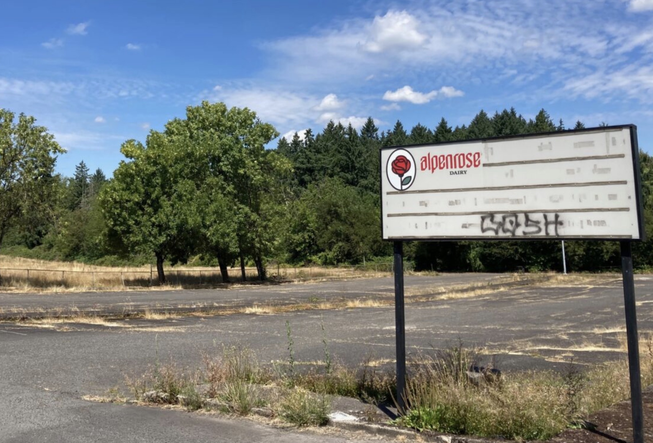

The Hayhurst Neighborhood Association (HNA) hosted Portland’s Planning & Development Manager, Kurt Kruger, for an information session Monday night about the possible residential development of the 51-acre Alpenrose Dairy site in SW Portland. The hybrid zoom/in-person meeting was attended by about 20 people who were mainly concerned about the large development’s effect on area transportation.
As we’ve been reporting, the upcoming development could spur significant improvements to nearby streets, or the additional traffic could just make things worse.
Kruger began by pointing out that Portland has not had a development of this size in “easily over a decade” and this is the first big development to come forward since the “Middle Housing” zoning changes which allow multiple units on a parcel.
He kept his presentation informal, and welcomed questions throughout. This worked well because the attendees were quite knowledgeable and the meeting moved along at a high level of understanding. They brought up all the issues associated with a development this size and asked about traffic impacts on all the site’s frontages, as well as intersections in the larger area.
I’ll focus on SW Shattuck Road, partly to whittle down the complexity of an enormous development, but also because Shattuck illustrates one of the core difficulties with building active transportation facilities in southwest Portland.

“What would have been a couple hundred-unit subdivision is now a couple hundred units with a big asterisk attached to it. Is this two hundred homes, or two hundred five-plexes? How do we plan for that? So this is a big test for the city.”
– Kurt Kruger, City of Portland Planning & Development Manager
Shattuck improvements?
Early in the conversation, questioners homed in on improvements to Shattuck Rd, which is one of the streets the dairy fronts, and which, by code, the developer is required to bring up to city standards. Here’s one exchange:
Question: What does “fixing Shattuck” look like?
Kruger: Almost every street is planned to have a typical sidewalk, planting strip, street trees, street lights, fire hydrants. In addition some streets are planned to have separated or widened bike facilities. Shattuck is one of those roadways where we would want to have a bike facility.
In a perfect world, we would be widening Shattuck on their side of the road, putting in a bike facility, put in a curb, collect the stormwater, and put in a planting strip, street trees, street lighting. And then a separated sidewalk. That’s the standard.
There is a big “but.” Southwest is different. And it is not always easy to get the standard City of Portland—what works on the eastside—here on the westside. And so this is often where we get into an interim conversation with applicants to right-size the improvement to fit the environmental conditions that we have here.
So if we’re working around big trees, steep hillsides, retaining walls—it’s possible we could be looking at a mixed-use path. So a widened, shared bike/pedestrian improvement on one side of Shattuck, versus that standard curb-separated sidewalk and bicycle facility.
So I don’t have any answers, but those are the iterations we would go through.
What didn’t get said
Requiring the standard frontage improvements along most of Shattuck is not possible because it lacks a formal stormwater conveyance system. Water from the road eventually makes its way into Fanno Creek. Without a stormwater treatment facility (like the rain gardens off of SW Capitol Hwy) the creek can’t handle the increased stormwater run-off from bike and pedestrian improvements.
What I was listening for, but didn’t hear, was that the Bureau of Environmental Services (BES) would be providing stormwater facilities along Shattuck Rd. It doesn’t appear that will be happening, and without BES stepping in PBOT’s frontage requirements will be limited to what can be done under the existing conditions along the road. This typically means, as Kruger suggested, a widened road or shoulder, usually without a curb, similar to what was built on SW Gibbs Street.
As Kruger later explained, his “interim conversation” is the Public Works Alternative Review, in which permitting bureaus determine what will be required of the developer. The public will want to keep an eye on what the PWAR requires, will a multi-use path be protected, or somehow separated from the road?
The problem
Portland builds its sidewalks and bike lanes piecemeal, one frontage at a time. In areas of town which are already built out, and which have already resolved their stormwater issues, this doesn’t matter so much.
The problem for the southwest is that you can’t build an entire stormwater system property by property—pipes need to connect. Lacking formal stormwater conveyance, the region densifies without making progress on its sidewalk and bike networks, and this perpetuates the area’s dependence on cars. This poses a particular hazard for residents in subsidized housing for whom owning a car may be a financial burden.
In the over half a century since the City of Portland annexed southwest, it has never come to terms with the area’s inadequate infrastructure. And even today the city doesn’t seem to have any intention of resolving the issue. So southwest muddles along with a drains-to-streams stormwater system appropriate for an early-20th century agrarian economy, even as the city tries to solve a 21st-century housing crisis.
A possible solution
Kruger, perhaps because of his role, spent the bulk of the meeting talking about the developer, and what the city would possibly require of them. Toward the end of the evening, however, one questioner tried to shift the focus, “What would the city feel its responsibility is, separate from the applicant?” Kruger might not have understood the point of that question, as he pivoted back to discussing the “safety for all modes” language in code, and what the city could require of the developer. His quick shift back to the applicant’s obligations is in itself telling.
“Would the city support going to our congressional delegation to elevate this project, because that is what it is going to take. What is your political sense of that?” asked another attendee.
“I am reluctant to say too much right now because we are truly trying to come to grips with PBOT’s fiscal cliff,” Kruger replied. He also mentioned that the southwest does not compete well with other areas of the city for capital projects because the stormwater issues and terrain make building in the southwest expensive compared to flatter neighborhoods on the eastside. The city can get more bang for its buck in other parts of town.
He concluded, “I can’t touch the federal delegation and congressional dollars, it’s just not my bailiwick, and I would be really over my skiis inappropriately if I were to take a guess at that.”
As someone working within the bureaucracy, that is probably the prudent answer. But our city government is on the cusp of becoming more representative, and $100 to 200 million in state or federal money could provide the stormwater facilities needed to put in place the spine of pedestrian and bike networks in southwest.
Portland’s new permitting group
Two weeks ago, the city council unanimously approved consolidating the permitting process into one entity. This is a big deal, and is the first action to come out of last winter’s permitting survey of development stakeholders (the one that reported bike parking being seen as burdensome). The new entity will have a director who will have authority to “resolve conflicts, make decisions regarding development review and permitting services to the community, and personnel decisions.”
Last January, Kurt Kruger began working in a newly created position overseeing staff from four of the seven city permitting bureaus—Water, Urban Forestry, Transportation and Environmental Services. Prior to that, he was the manager of PBOT’s Development Review section. He seems well-positioned to ascend into the directorship of the consolidated permitting group that city council just created.


Thanks for reading.
BikePortland has served this community with independent community journalism since 2005. We rely on subscriptions from readers like you to survive. Your financial support is vital in keeping this valuable resource alive and well.
Please subscribe today to strengthen and expand our work.
‘Or, we ould just give you a 6′ paved shoulder to share with the hundreds of extra cars now pouring onto Shattuck!’
Kruger is telling people this will go to Alternative Review, where ped facilities go to die, and they will get nothng and like it. Mr. Kruger is hostile to developers improving frontage, and appears to favor big programs that cost taxpayers millions and happen once a generation (see Capitol Highway).
‘It is difficult to get a man to understand something, when his salary depends on his not understanding it.’ – Upton Sinclair
Kruger has spent his time at development review making himslef the go-to guy for greasing rails when it comes to developer responsibilities in SW ROWs; he is now the likely candidate to assume control of the entire permitting process Rubio is setting up, meaning this will only get worse.
Lisa told me a story about the last Pedestrian Coordinator at PBOT, Michelle Marx, before she left (when she had no fear of repurcussions and zero f*cks left, apparently). Discussing the internal battle at PBOT between cars and active transit, Marx said: “what you’re saying is we need to circle our wagons.”
I am saying it was too late then; the wagons have been burned and the riders have all died of dysentry. It is going to take dramatic action to prevent what PBOT is giving SW: a future of low and middle-income residents packed into developments with no safe access to transit, forced to own and drive cars, which then swarm onto the paved shoulders filled with pedestrians trying to reach what few buses there are, their school, or a shopping place. To hell with Vision Zero, to hell with climate change.
Thanks, Kurt!
Comment of the week! (but it will never be picked b/c it’s critical of a city official, I’d wager).
I’m leaving town for three weeks, so imagine there won’t be a “comment of the week” until October. (how’s that for sidestepping the issue?)
This was one of the clearest explanations I’ve read of the factors affecting sidewalk construction in SW. Thanks, Lisa!
Regarding the new permitting authority, that would consolidate development services:
Can someone tell me why the… ahem… Bureau of Development Services wouldn’t handle this?
I can certainly imagine that BDS can’t do this new job currently, but wouldn’t they just need greater staff and regulatory authority?
Am I wrong that this seems like a bad idea that will just bloat our middle management further?
Is the problem just that other bureaus (PBOT, Water, etc) don’t want to get subordinated to an existing bureau, but could stomach reporting to an “new group?”
Charley, those are good questions. We’ve been covering the issues with permitting over the past seven months or so, beginning with a survey Commissioner Rubio and BDS sent out last winter to users of the permitting system. I suggest looking through those posts. A good place to start is:
https://bikeportland.org/2023/03/15/developers-say-bike-parking-rules-are-biggest-reason-for-housing-delays-371416
I think this role consolidates the infrastructure bureaus that typically participate on the public side of property lines. It’s been herding cats to get these independent bureaus to work together. There’s probably a sense that BDS, which focuses on what happens on private property, doesn’t have the breadth of knowledge to handle any of that. It seems like a prudent start to fixing the mess that is development review. From my experience, this may be an opportunity to cut some of the middle management and consolidate decision-making, if the opportunity is taken.
I just don’t get the city’s logic here. They are saying that it’s fine for the developer to add miles of streets and thousands of square feet of paved driveways, not to mention roof area, and it’s fine for all of that stormwater to run untreated into Fanno Creek.
But the moment they add a sidewalk and a bike lane on Shattuck, that stormwater triggers a treatment requirement that they can’t handle?
I hope someone can explain how one type of stormwater behaves differently from the other type.
Hi Fred,
I’m glad you read the article. And you have a really good question that I chose to not deal with in the post because it’s a whole other ball of wax.
My guess is that the developer will be required to build an on-site stormwater containment facility to handle run-off from the residences. In other words, they will be required to treat stormwater run-off from the impermeable surfaces on their own private property.
When you move into the street, with sidewalks and bike lanes, you are on public property. It’s a difference between public and private, and who is obliged to pay for what. The body of jurisprudence which has ruled on these issues, going back decades, is known as Nollan/Dolan/Koontz.
You could probably make the developer build sidewalks on the frontage, but the city, for over 50 years, has not managed to get stormwater infrastructure into SW. So the road is not prepared for the addition of a sidewalk or bikelane, even if the developer were willing to put one in.
Nollan/Dolan/Koontz says there are limits to what a jurisdiction can ask a developer to pay for, and entire stormwater system is too much.
BES explains the city’s position in this document: https://www.portland.gov/bps/wpdx-town-center/documents/bes-stormwater-considerations-and-rationale-zoning-recommendations/download
(I couldn’t get the document to load, the site says “it will be fixed soon.”)
So really it is a political problem. You are correct, southwest is great for photo ops and check writing, but it is dumbfounding to me that the city has avoided building basic, meat and potatoes, “this is what a city does,” infrastructure in the region.
I don’t see any indication that the city plans to change their ways. They are creating carmaggedon. “You are getting Capitol Highway and nothing else,” I was once told on the side of a road by someone in a position to know.
Thanks, Lisa, for the explanation, but it’s absolutely crazy to me that people in gov’t, who are supposed to be looking out for EVERYONE’S best interest, are allowing this situation to continue without addressing it.
The root cause of the problem, in my view, is that city continues to require developers to do THEIR OWN thing which means the developer never has to account for the public good. The city could build out the necessary infrastructure and require developers to pay fees to plug into it, but they don’t do that either.
Our only hope is that actual professionals start running city gov’t after the 2024 election and figure out the right way to do things.
Fred, if you pave 500 sq ft or more, you have to treat the runoff, either by a holding pond or some such before dispersal, or down a sewer pipe. Hard to get dispersal in our clay hills. I have been present when officials explained that there’s room in the sewers for some 5000 new homes, their roof and driveway runoff, their poop, the street runoff… and not ONE cubic inch left over for walkway or bike lane paving.
Funny that.
Lisa, I wish you would come over to SW Garden Home and SW 46th to see the new development on the old Catholic church lot. Seven narrow houses have been constructed on the back part of the property. One narrow lot along Garden Home remains undeveloped, along with three narrow lots that make up the old parking lot on the corner of SW 45th and Garden Home. Apparently those four lots front the important Garden Home and 45th arterials so they would trigger system development charges and possibly street improvements. So the developer has gone ahead and developed the seven skinny lots that front SW 46th and has – hilariously – paved a narrow center strip of 46th so that buyers of these $800k+ skinny houses (with tiny yards) have a smooth drive to their driveways. There is no sidewalk, bike lane, or any other improvement to SW 46th.
Win for affordable housing? Nope.
Win for public infrastructure and walking and cycling? Nope.
Win for the developer? Yes!
Thanks for the tip, I’ll take a look when I get back.
Did they bulldoze the covered TriMet bus shelter on the corner? Will it get rebuilt?
Do we know for certain what kind of housing will be built on this site. When I did a google search it came back that 193 homes are planned for the site. My guess these will be single family homes, not multi-family, and probably not affordable. Even at 193 single family homes the potential increase in drivers could be 200 or more. If I lived in the area this would be the best outcome. Yes its more drivers, but if the housing is multi-family units the number of drivers will be a lot more. I see there are two bus stops on Shattuck Road just across from the property. Some residents may use transit if then can get across a busy road to the bus stop.
The current application is for 307 lots (whether the developer intends all single family homes or multiplexes, we don’t know that yet). This is the uncertainty by PBOT mentioned by Kruger.
The bus stop on Shattuck (bus route 1 that runs only 4 times a day with no weekend service) is being removed with a new line #42 running all along Vermont with all day service https://trimet.org/forward/#1
Thank you for the update. After doing the math I figured the lot size will be about 5000 square feet each. At 50 x 100 feet not the largest of lots. I did come across a document from the city of Portland showing Residential Infill Options in R2.5-R20 Zones. In the document it showed an example of a 4-Plex on a 50 x 100 foot lot. I imagine this is the kind of housing that many on this forum would like to see built. The problem with this design is there was no parking and the location of this property does not lend itself to no car residents. I could be wrong but I still think it will be single family homes.
Remember, it’s not just the first pass of housing built by the developer, each subsequent single-family homeowner, long after the developer is out of the picture, has been given the right by Middle Housing policy to densify their property to four units.
So, let’s keep the arithmetic simple. Say the developer builds 200 houses on 50 acres, or a quarter acre each. Each one of those owners over subsequent decades can add three units. That is how you can, in theory, go from 200 to 800 units.
That is the uncertainty Kruger is talking about, predicting how much of that growth, at what rate, will actually happen and what they should anticipate for transportation planning.
The city at best will base improvements on those 200, or whatever the developer proposes; to be fair to developer, if they plan 200 homes, why should they pay for some unknowable future need? That’s on the city. And we know that the city will NOT do it; since the mid90s at least the city’s policy has been “densify first; after we collect all them taxes, then we put in the infrastructure to handle it!” When this was proposed back in 96, residents told the city to pound sand – add the infrastructure to handle the density as we go. Here’s Eudaly’s PBOT response to that, in the 2019 “Historical Context of Racist Planning:
https://www.portland.gov/bps/planning/adap/history-racist-planning-portland
Enraged, NIMBYism, racism, or good sense? Everyone knew the money was NEVER coming back to SW to put in those improvements, and residents decided the density could not be safely supported without them. The city evenetually adopted a different plan https://www.portland.gov/bps/planning/comp-plan-2035/documents/southwest-community-plan-comprehensive-plan-zoning-map-2001/download
You should read the racism doc; the language is deliberately chosen to demonize SW residents. It appears to be the attitude many at the city still have today: racists NIMBYs should get nothing. There are good reasons we might not get full improvements everywhere we wish; there are many places elsewhere ODOT and racism have created problems that need fixing; it IS expensive to do things here (hint: that’s why you make the developer help do it). But to simply proclaim ‘too hard too expensive’ and condemn a region to congestion, high traffic speeds, pollution, and reliance on cars is the exact opposite of what PBOT’s own statements of purpose say.
As for expense… say I have three children, and one needs glasses and expensive treatment for a debilitating but manageable disease. If I am PBOT, that last child gets a pat on the head and a hearty “gonna invest in the easy ons; good luck!”
I find this very depressing. I live between Shattuck and Scholl’s Ferry, and often ride my bike to work downtown. I used to ride up Patton, but there is absolutely no shoulder, and I am slowing down, so I’ve been riding down Shattuck to Beaverton-Hillsdale Hwy, up into Hillsdale, and then down Capitol to Barbur. None of it is great riding, but the changes to Beaverton-Hillsdale have been positive in my view. (It would be nice if they could clean the bike lanes once in awhile, but that’s another discussion.)
Anyway, speaking of another discussion, my dream would be to see Scholl’s Ferry between BHH and Sylvan converted from two uphill lanes/one downhill lane into two bike lanes and two car lanes, one in each direction. Right now, people going up Scholl’s drive like it is the Daytona 500. Really, they just race one another to the top. With e-bikes growing in popularity, I am seeing people RIDING THEIR BIKES uphill on Scholl’s. This is SUICIDE. There are blind corners where people routinely drive faster than 45 mph, and NO SHOULDER.
I don’t know anything about water treatment infrastructure or any of that jazz, but you could take out one uphill car lane and make it into two bike lanes with just some paint. Not great, I know, but way, way better than what it is now, without touching the pavement or widening anything. Just paint.
They “clean” the BH hwy bike lanes about twice a year, but you wouldn’t know that because they don’t remove all the ivy that is taking up half the lane!
One thing mentioned in the meeting not mentioned in the article is how Kruger believes that the impact from development will be big enough to warrant improvements to Shattuck beyond just the frontage of the property. He said what PBOT will require is still not fully clear yet as the traffic impact study (TIS) that the developer is required to do has not been done yet. However what I am hopeful for is for all of Shattuck to have at least some kind of improvement.
I have heard that Multnomah is getting ready to repave Scholls Ferry soon and just came across this from a 2023 budget working session https://multco-web7-psh-files-usw2.s3-us-west-2.amazonaws.com/s3fs-public/FY%202023%20BWS%20Questions%20-%20DCS%20Responses.pdf. Most notably is this comment
Although I don’t know who to contact to make this happen. Multnomah County Chair Vega Pederson perhaps?
If I remember properly, past discussions mentioned putting in a traffic light, so that might be the ‘beyond de minimus’ discussed. However, at one point, conversations with developers appeared to forego sidewalks INSIDE the development. They did that already in a Hillsdale project IIRC, It is possible they fear the uproar and surprise us by making it an innovative, model project of how to address tough spots in SW while improving safety… but they have avoided doing that so far, so why spoil a perfect record?
Scholls needs a road diet between SW Raleighwood Lane and 700 feet south of where it meets SW Raab Road.
Contact Jon Henrichsen at Multnomah County. He’s the Transportation Division Director/County Engineer for Multnomah County.
Thank you. I submitted a comment. You can too!
https://www.multco.us/transportation/webform/contact-form
His email is jon.p.henrichsen@multco.us
Thank you very much. How encouraging!
I agree that the county needs to remove that uphill passing lane on Scholls Ferry, which causes people (mostly guys in trucks) to drive like demons up that hill. I too have made the mistake of trying to cycle up it and fortunately I survived.
Todd you can have a much nicer ride for a small portion of the trip you described by turning right onto Cameron off Shattuck avoiding the super narrow curve on the hill, which feels like the most dangerous part of riding Shattuck. I use 54th north to Martha and there are many lovely, no stress, non-life threatening ways to reach the BH bike path from there. Enjoy.
How is it that PBOT can apply for a bikeway at the federal level, but BES or Water bureau cannot apply for below grade infrastructure at the federal level? Is there a disconnect between connectivity for bikeway and connectivity for stormwater / water/sewer lines underneath the bikeways…? what do we need to do to make projects in right of way that improve utilities, water/sewer, storm water, with bikeways and sidewalks on top that make everyone in Portland happy ??? jfc
Washington County requires street / stormwater improvements. Somehow, a neighborhood closer to downtown Portland won’t require those. Failed leadership. This is impossible to fathom ten years ago.
Shattuck needs diverters to reduce car traffic, not widening.
It definitely ends up being a cut regional through for folks going to Garden Home/Tigard/Metzger and beyond. The big 6 way intersection at BH/Oleson/Scholls feels like it takes too long to get through at rush hour so folks will choose a quick, speedy, fun, curvy road with ZERO chance of being given a ticket as a shortcut as long as they can.