A major re-think of land use policy and transportation infrastructure in a section of southeast Portland could be transformative. How much so remains to be seen.
As we reported back in August, the Lower Southeast Rising Area Plan, a joint effort from the Portland Bureau of Transportation and Bureau of Planning & Sustainability, is an attempt to “address the historic lack of infrastructure investment in parts of Southeast and East Portland.” The plan focuses on SE 52nd Avenue from Woodstock Boulevard to Flavel Drive and SE 72nd Avenue from Woodstock Boulevard to the Springwater Corridor, encompassing the Brentwood-Darlington neighborhood and parts of the Ardenwald-Johnson Creek, Lents, Mt. Scott-Arleta, and Woodstock neighborhoods.
Since last August, PBOT and BPS have come up with several scenarios for both community development and transportation changes in the area, which they outlined this week in a detailed online open house and video presentation.
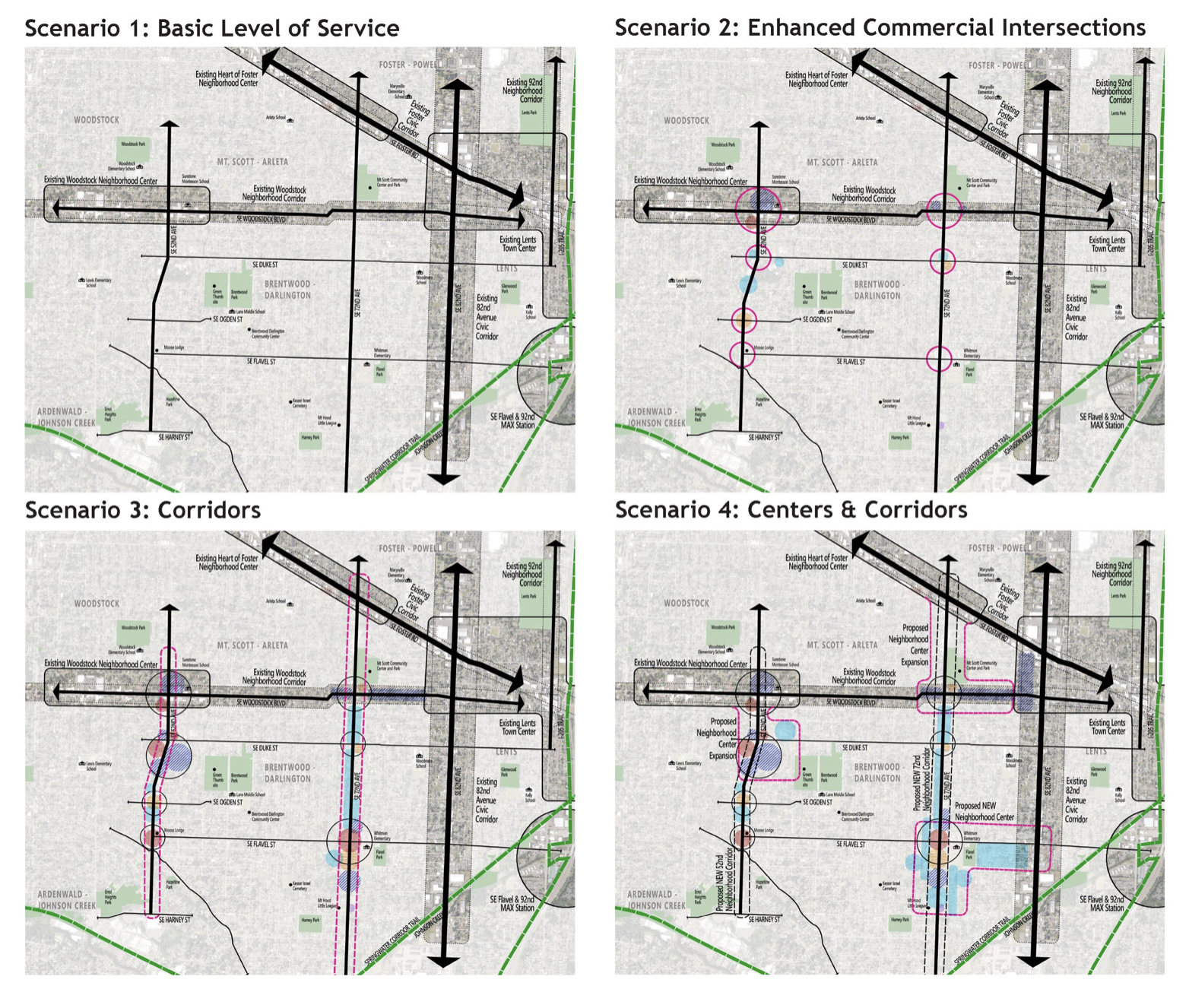
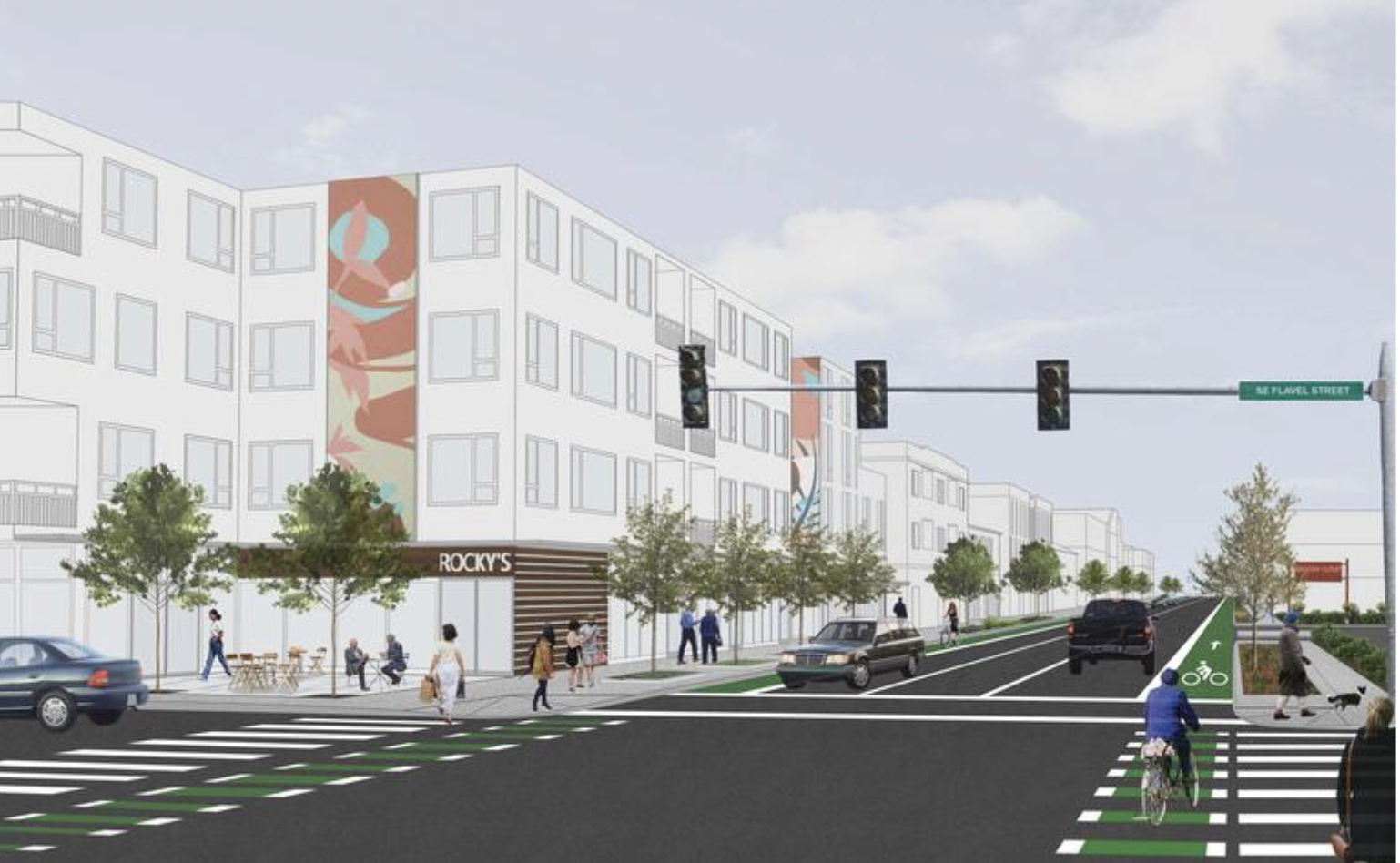
The four Community Development Scenarios (above) “illustrate different land use and community development futures” for the focus areas of SE 52nd and 72nd Avenues and vary in the level of changed they’d trigger. At one end of the spectrum, the city suggests building on current land use patterns to create new multi-unit housing and enhancing existing commercial sites. At the other end, SE 52nd and 72nd Aves would undergo dramatic changes that would enable significant mixed housing and retail development potential (see lead graphic above).
As far as transportation changes, the plan acknowledges this area has insufficient bike lanes and sidewalk gaps (or none at all). This leads to wasted potential for better active transportation in these neighborhoods because, as the draft plan states, the area has a “compact street grid provides opportunities to move throughout the area without a vehicle.”
For example, the Springwater Corridor trail, a major east-west biking corridor, should be easily accessible for people who live in lower southeast. But because of the bike system gaps, many people have to go completely out of the way to get to it safely.
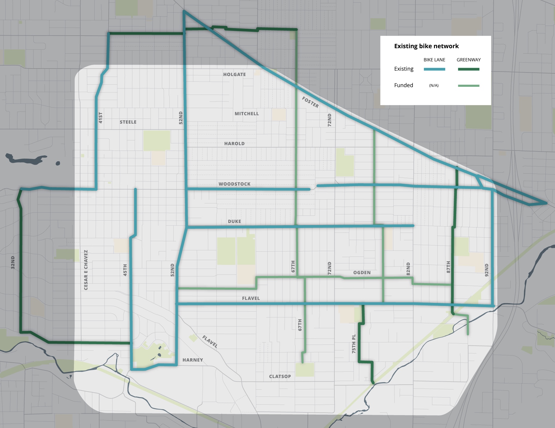
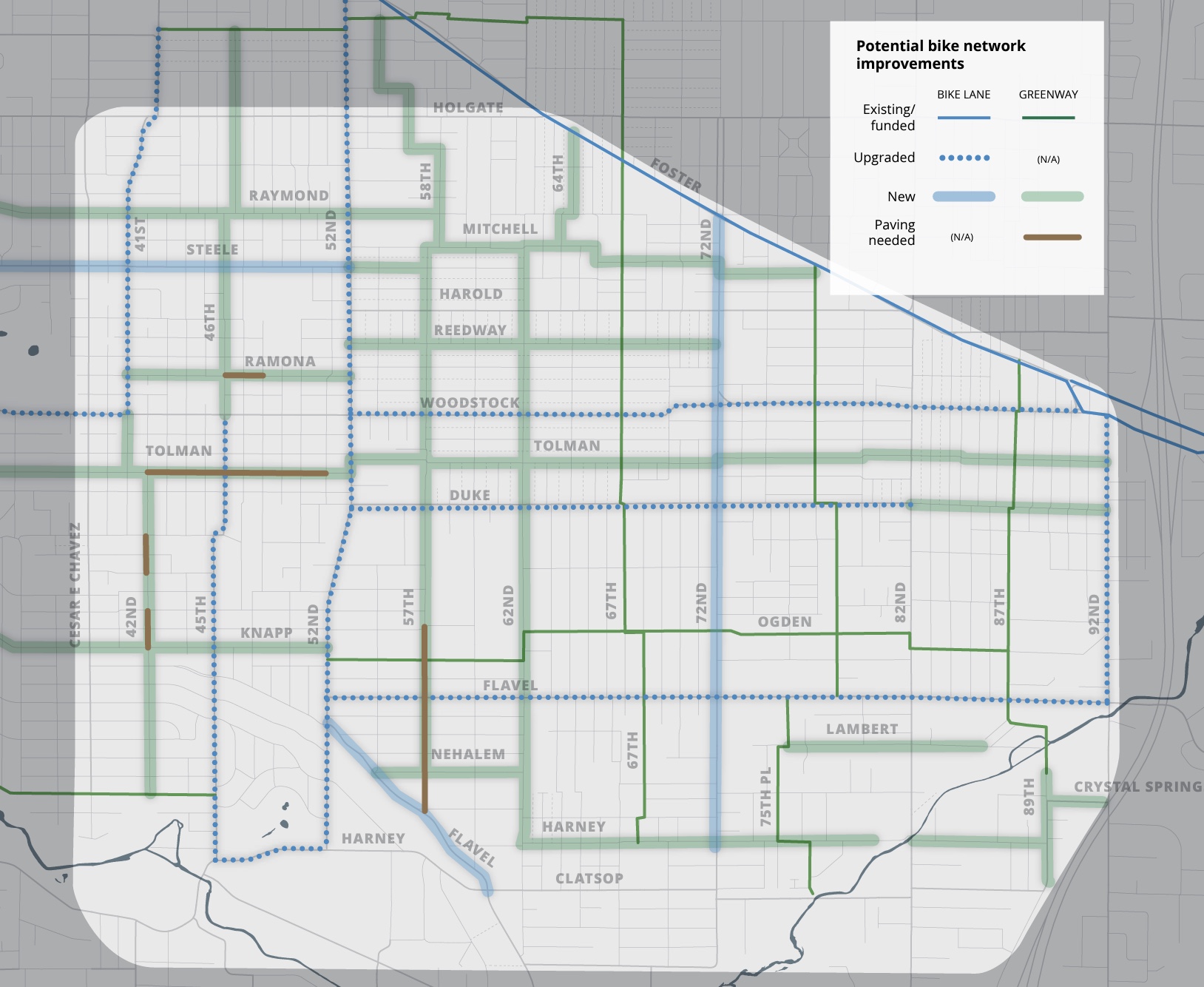
(Existing versus potential bike network.)
While people biking around other parts of the city have ample neighborhood greenway options, there are precious few greenways in this part of town, and the bike lanes are often located too close to car traffic with only a very slight barrier for separation.
Planners say they’ve received feedback “about the need to improve street conditions for walking and biking as well as to calm/slow motor vehicles” and have developed a list of potential projects to address these concerns.
Some of these potential projects include adding crossings on a large stretch of Holgate Blvd, filling the bike lane gap on Woodstock Blvd between SE 69th and SE 72nd, and doing sidewalk infill in many places in the area. The plan also includes bus system changes that would create more continuous transit access across Woodstock, 72nd Ave and Flavel St.
Now PBOT and BPS want feedback to learn just how bold they should be with future changes. Take a look at the survey and online open house where you’ll learn more about existing conditions and the scope of what’s possible. The final plan is expected to go in front of City Council for adoption the end of this year or beginning of 2023.


Thanks for reading.
BikePortland has served this community with independent community journalism since 2005. We rely on subscriptions from readers like you to survive. Your financial support is vital in keeping this valuable resource alive and well.
Please subscribe today to strengthen and expand our work.
Obviously PBOT should go with the most ambitious plan. However, I find it disturbing to see that the rendering of their most ambitious plan includes an *unprotected* bike lane AND a center turn lane for cars! Are they planning for 1999?
Get rid of center turn lanes; make all bike lanes actually protected (not just with plastic wands); make sidewalks nice and wide; prioritize public transit; make sure the tree canopy is relatively mature at planting. We don’t have time to waste; I fear PBOT and its handlers lack a sense of urgency because of too much car-brain.
Yeah, maybe I’m just imagining it, but between this render and the ones in the 122nd Ave proposals, it almost feels as if PBOT is delusionally imagining that they’re planning infrastructure for some kind of Amsterdam-esque culture where you can build fietsstraats/”cars are guests” streets—i.e. jumping the gun and being *too* progressive (it took Amsterdam like fifty years to build cycling culture to the point where they could do stuff like that; maybe PBOT planners are impatient and think they can skip a few steps).
Or maybe I’m completely wrong and it’s just classic car supremacy stuff. I suppose when it comes to urban planning, it’s hard to distinguish wishful thinking from incompetence (see also: barren plazas that planners seem think people actually want to hang out in).
I looked at the google street view after reading your comment:
https://www.google.com/maps/@45.4688154,-122.5893237,3a,75y,182.99h,93.48t/data=!3m6!1e1!3m4!1sEmkhEOHaD61X1sPqdg4FWw!2e0!7i16384!8i8192
If you take away the hypothetical future building that dominates the rendering, there’s really no change beyond painting a narrow bike lane on each side. The rendering doesn’t even show changing the outdated angled curb ramps at the corners, so that you literally cannot enter or exit the (also outdated) crosswalk across 72nd without encountering a curb. The sidewalk on the right actually look narrower than what’s there now.
Renderings can be great for helping people visualize, but they can also beguile. In this case, a more accurate, less distracting graphic from PBOT might have been to take a photo of that intersection, and scrawl “add narrow painted bike lanes” with a marker, because that’s all that’s really being proposed in the rendering.
I’ll resist the huge temptation of making snide and snarky remarks about the image at the top, and simply ask, how is the city proposing to pay for all the proposed street improvements in Brentwood-Darlington?
East Portland, Cully, and Southwest are still waiting for most of their promised improvements for over 30 years…
I used to live near 72nd & Flavel and went to the grocery store that was there quite often. I can’t even begin to imagine their renderings happening in that 4 corners.
What happened to the Middle Holgate bikeway (project #70031 in the TSP)? Also, it seems silly to upgrade the existing bike lanes on Woodstock while leaving a gap between 41st and 52nd. Woodstock Blvd is 80′ wide, so there really shouldn’t be a problem adding bike lanes to the street.
I think that would be great as well, but the Woodstock Business Association believes that on-street parking in that stretch of Woodstock is more important. That decision was made over a decade ago, so perhaps the tide has changed.
Thanks to the construction we have about two-thirds of a block of protected multi-use path around 50th. I enjoy it, though I have had to reposition the fencing and pick it up a few times.
I really really hope for bike lanes on Woodstock too! There’s plenty of parking in surface lots around Safeway and other businesses, plus side streets, that street parking on Woodstock can be easily converted to bike lanes.
Is PBOT working with the Bicycle Advisory Committee on this? I just took a quick look at the potential plans and I didn’t see protected bike lanes in any of them… did I miss them, or is this another situation of PBOT pretending that paint will protect bikers from speeding/distracted/angry drivers? Please, BTA, make them listen to the biking community! This is the time to write those letters and send them back to the drawing board to create safe bike routes!
Looking at the lead graphic: Help me, understand…so ‘classic’ bike lanes (vs protected bike lanes) are still labeled as an element for the city as “most ambitious vision”?
Taylor Griggs – can you swap the placement of the graphics of the two bikeway networks, as the logic and text (existing vs planned) do not match the left & right placement (planned vs existing). [It hurts my planner’s brain and may confuse many others.] Thx for the hard work that you do to inform us.
Thank you, image order now matches the caption.
Thanks Lisa!
I realize the rendering is quick and conceptual, but it seems sloppy of PBOT to show the crosswalks going one direction as white bars, while those going the other direction as old-fashioned lengthwise lines. The message I get is, “Trust us to redesign SE’s transportation network, even though we can’t draw a crosswalk correctly in a rendering”.
“this area has insufficient bike lanes and sidewalk gaps (or none at all). This leads to wasted potential for better active transportation in these neighborhoods because, as the draft plan states, the area has a ‘compact street grid provides opportunities to move throughout the area without a vehicle.’”
Just to offer a different take. ‘unimproved’ sections are *great* for ‘moving throughout the area without a vehicle (assumed to mean motorized.)’ The lack of improvements don’t impede human mobility—after all we’ve been doing this for tens of thousands of years.
I may be too old to appreciate how special infrastructure is required for me to bike/walk/feel safe, when the lack of this infrastructure does/has done more to discourage fast driving, which I still view as the chief threat.
Exactly. Most of my favorite streets for walking have had no sidewalks. My own neighborhood fought PBOT successfully to NOT install sidewalks.
Of course busy streets should have sidewalks. But if you take a minor street with no sidewalks and perhaps a poor road surface, and add sidewalks, the result can be forcing people walking onto a narrow sidewalk (instead of having the whole street available), more vehicle use, and vehicles travelling much faster, with drivers more entitled (and with some legal justification) to feel as the roadway is only for vehicles.
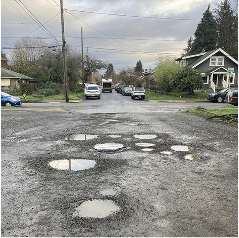
I live in B-D and while I like walking on unimproved streets around Woodstock and Eastmoreland, the ones in Brentwood-Darlington are often places where trash is regularly dumped, potholes turn into mini lakes in winter, and out of control blackberry bushes hide more trash and rat nests. SE Cooper St. is a good example of this. As for biking, I hate biking on unimproved gravel streets, and even with my hybrid/commuter bike’s not that narrow tires, I find it challenging and unstable, so I avoid them. I’ve gotten used to the no sidewalks aspect of the neighborhood, but I really do hope they pave some gravel streets if only to create a more connected biking grid that is accessible to all ages and abilities.
I think from a planner perspective, keeping the street designs vague for now is very intentional. When these kind of early planning ventures start up, going straight to design creates a lot of barriers for revising later, especially when you are still looking out over a whole district. Also these ‘progressive’ renderings that come out of designing protected bike lanes usually become lightning rods for criticism for many folks early on, especially those concerned about on-street parking being given up.
But just imagine….How AWESOME it would be to have protected bikes lanes on 52nd and 72nd to connect folks N-S then look at providing a Tolman Neighborhood Greenway for E-W folks? I hope the stars align, but I can be honest: this is not my neighborhood, and I’m sure there’s better ideas floating out there.
That’s it? That’s not ambitious, that’s the status quo with a bit of paint added.
I think that well into the 21st century, everyone can agree that the bike lane should be on the other side of the trees. (Also the major intersections should be protected.)
One thing I find weird is the use of green paint in the bike lane. It’s not needed there, it’s only needed at the crossings.
Whoa, Rocky’s!
Weird. Why does PBOT always ignore the commercial centers? If you’ll note, the commercial blocks of Woodstock don’t have an upgraded line. I can vouch it’s pretty terrible from a rider’s/walker’s perspective. The least they could do is daylight the intersections and put in more than one crosswalk per mile.
they created a gap through the commercial area on N Interstate and it is truly horrible. I believe it is in the name of parking, but it truly induces car trips since biking there sucks so bad.
Totally agree about inducing car trips! My neighbors who live a 10 minute bike ride from Woodstock would never bike there because they are afraid of the car traffic. So they become the traffic themselves and just drive there…
I fully agree with all you wrote, Andrew! We need bike lanes the commercial part of Woodstock, more protected intersections, and more crosswalks! I contacted PBOT about the lack of crosswalks on Woodstock, Duke and Flavel before because this is against their own rules for crosswalk frequency. They replied, saying they sent a guy out at 11 am on a Monday before COVID to measure traffic volumes, which of course were low since that’s the time when most are at work, and concluded that xwalks are not needed. Seriously! How about measuring during busy periods like rush hour or weekends?
I find it strange that there seem to be no new Springwater connections even in the most ambitious scenario. For example, SE 73rd, a wide paved street, already connects to the Springwater, all one would need to do is install bollards in place of the gate here.