One of the most underdeveloped parts of Portland has taken a big step toward catching up to the rest of the city.
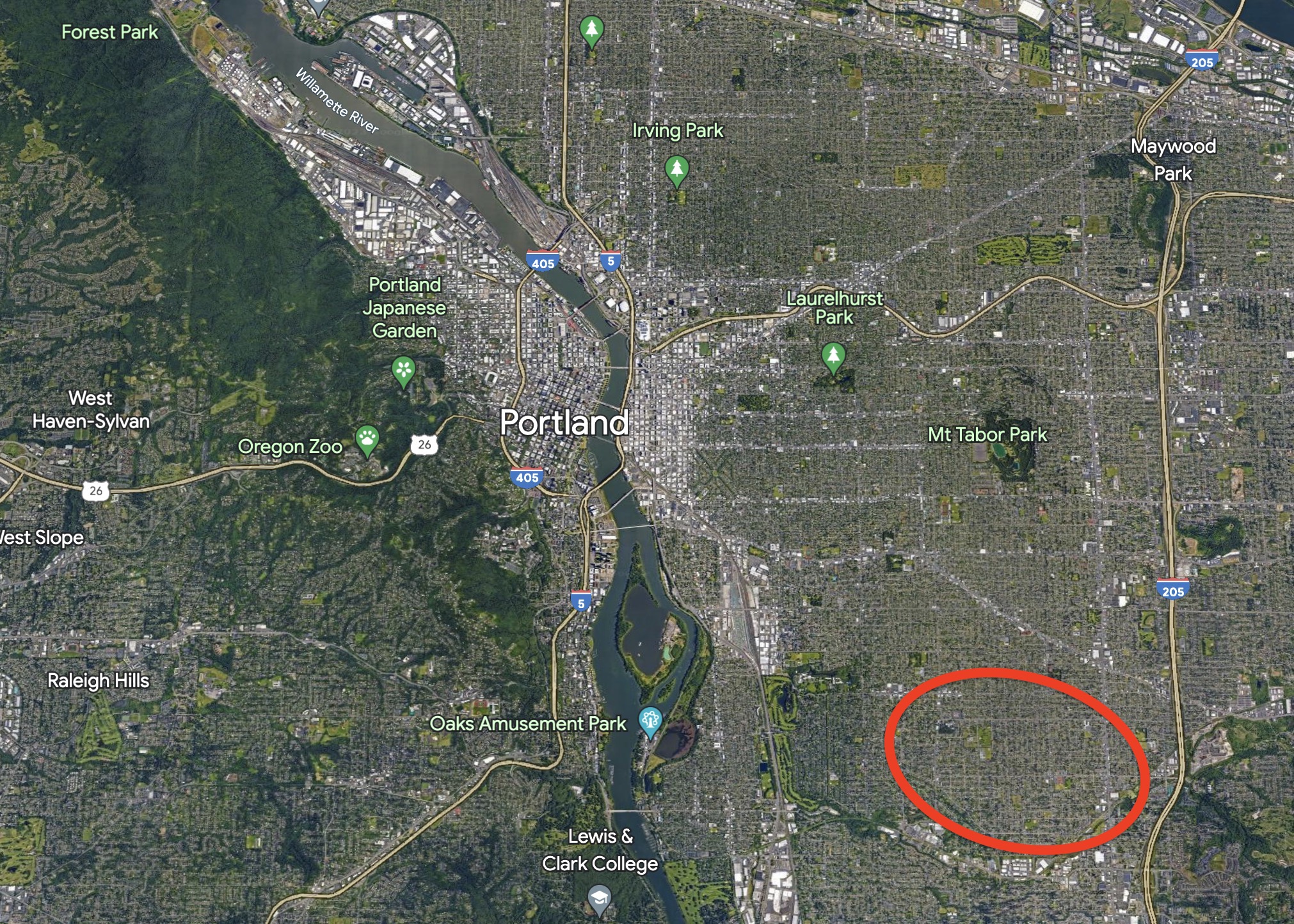
After two years of planning and public outreach, the City of Portland has released a draft plan for how they’d like to hasten development of the lower southeast — an area that includes the Brentwood-Darlington, Lents, Ardenwald-Johnson Creek, Mt Scott-Arleta, and Woodstock neighborhoods.
With a mix of land use and transportation changes, the idea behind the Lower SE Rising Area Plan is to boost neighborhood businesses, create more — and more affordable — housing, and make it easier to walk, bike and take transit. The ultimate goal is to give people the opportunity to meet daily needs without having to drive. Last week the Bureau of Planning and Sustainability (BPS) and the Bureau of Transportation (PBOT) released a draft version of the plan and it’s our first look at what city planners recommend for helping this part of the city catch up to the rest of Portland.
Portland’s lower southeast wasn’t annexed into Portland until 1986 and prior to that it was “yellowlined” — a federal designation on loan maps right above “redlined” that made it hard to get home loans. There are some good bones from historic rail service (both urban streetcar and proximity to the former train that ran on the Springwater Corridor), but for the most part lower southeast remains behind other parts of Portland when it comes to business access and active transportation infrastructure.
“Lower SE Portland shares many physical characteristics with East Portland: gravel streets and missing sidewalks; a disconnected street network and limited bus service; and few neighborhood stores, restaurants, and other conveniences, so that residents must drive to meet their daily needs,” reads the draft plan.
To lift up the area, BPS and PBOT recommend a two-part strategy of zoning code changes and transportation projects.
Land use and zoning
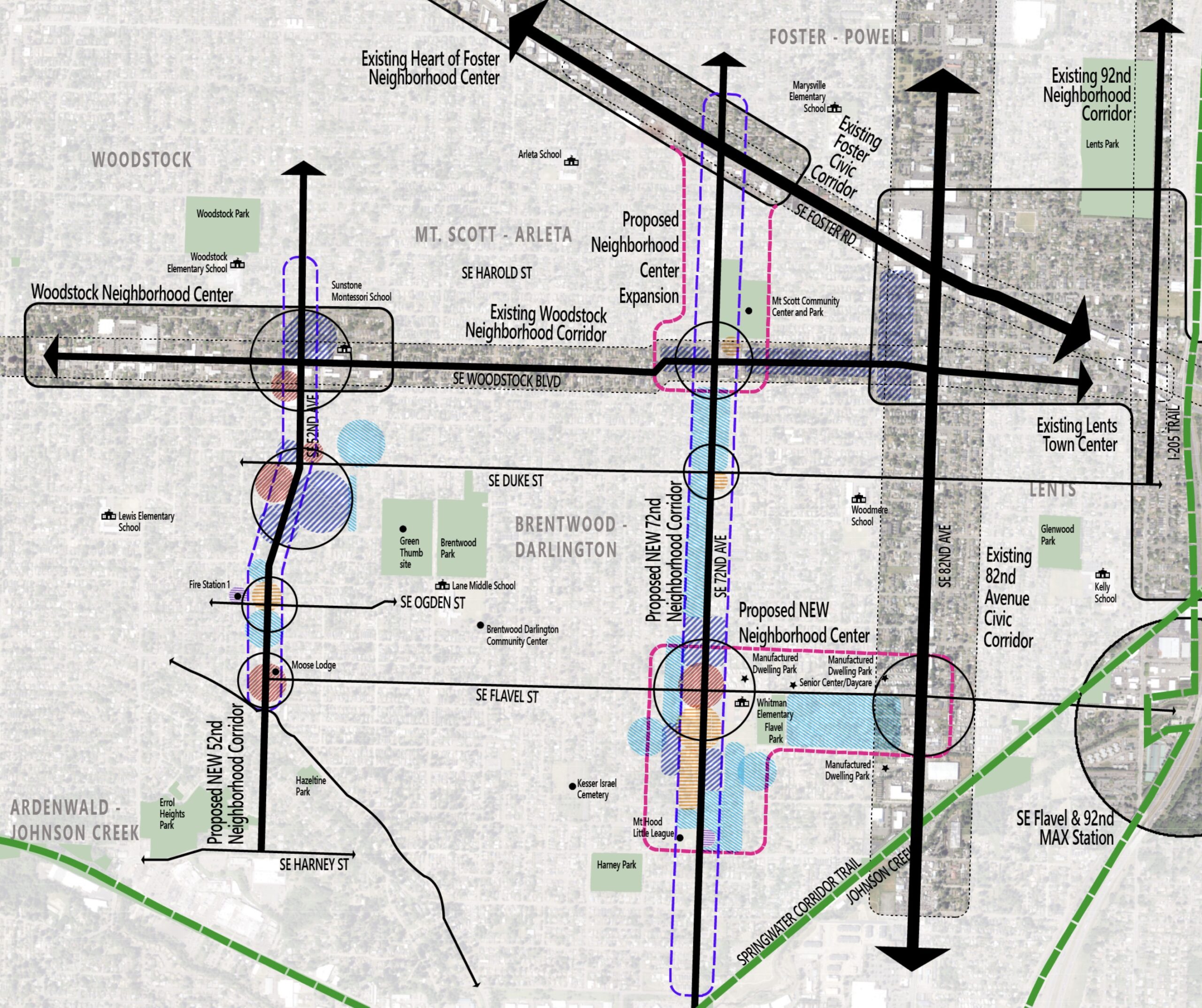
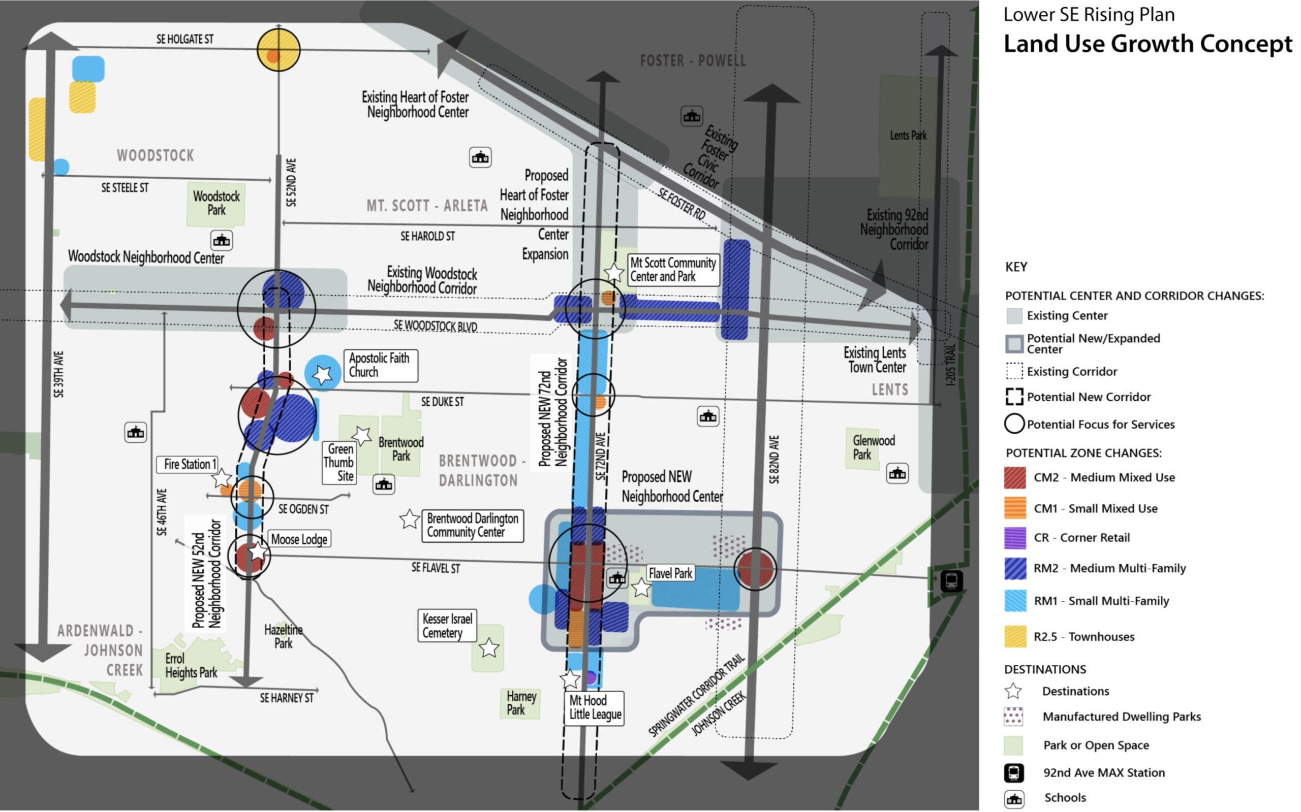
On the land use side, BPS proposes a new business district around SE 72nd and Flavel that would, “serve as a hub for commercial services with additional housing options” and “fill in a substantial gap in access to services in this area of Portland.” That district would be part of a new neighborhood center that would extend east along Flavel to 82nd. This would help give the Brentwood-Darlington neighborhood something on par with how 72nd feels just to the north at Woodstock and at Foster. Currently the Flavel/72nd intersection is bordered by parking lots and/or car-related businesses and low-density housing.
The city also proposes zoning code changes to the area around 82nd and Flavel that would allow for mixed-use instead of the commercial and light-industrial uses it has today in order to, “encourage a small commercial hub that is more pedestrian oriented and allows businesses in mixed-use buildings with housing on upper floors.”
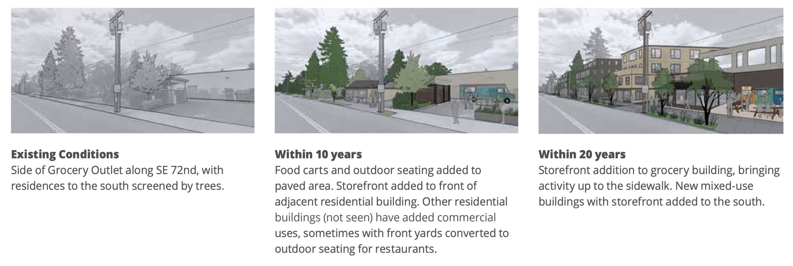
72nd would become a much more prominent and pedestrian-oriented street as part of this plan. The current “neighborhood center” and “pedestrian district” that exists on the street at Foster would be extended south to include the Mt. Scott Community Center and Arleta Triangle (which not boasts a public plaza). The city is also proposing to allow 3-4 story buildings along SE Woodstock instead of the 2-3 stories allowed today. And around the new public plaza at the Arleta Triangle, the plan recommends a zoning change that would allow for commercial and mixed-use developments to, “support its emerging role as a community hub.”
52nd would also see changes if the proposals in the plan are adopted. It would become a “neighborhood corridor” (along with 72nd), which opens it up to zoning changes that would allow more housing, neighborhood businesses and small, 2-3 story multi-family developments.
Transportation
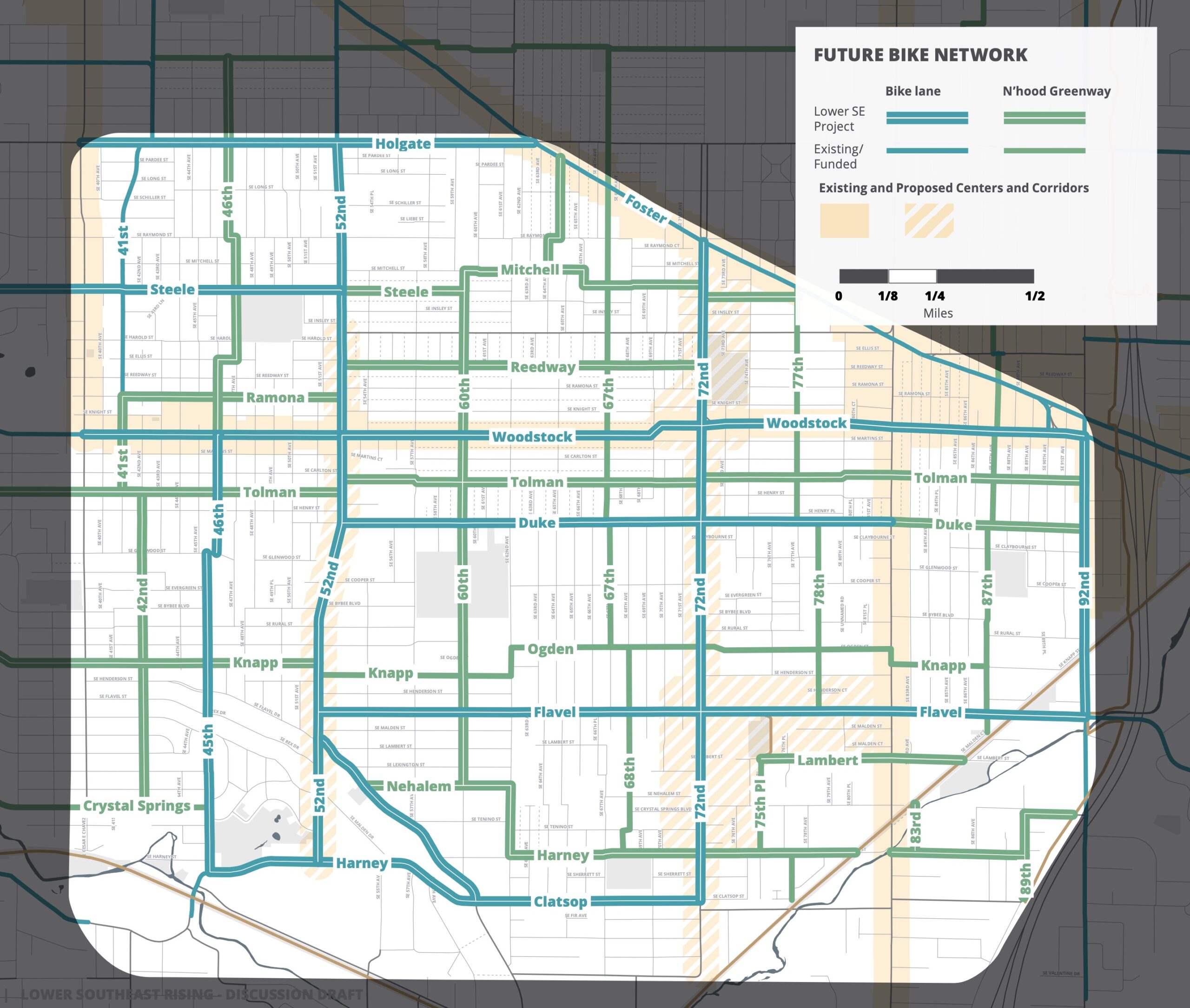
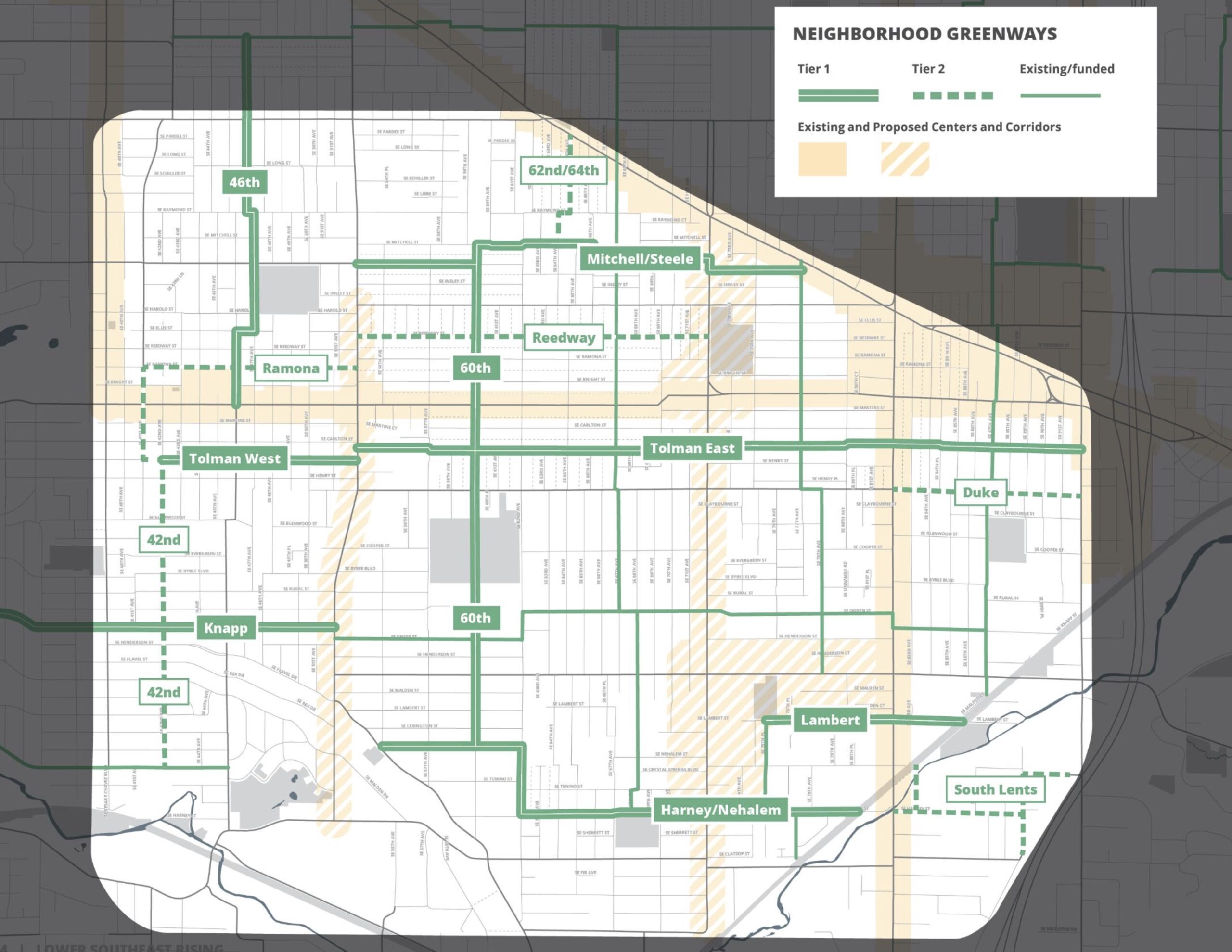
To support the land use changes, the city is also proposing transportation improvements to make it more attractive to walk, bike and take the bus. Since the area was annexed so late and historically underinvested in, then went from being dominated by streetcars in the early 20th century to being car-centric by the 1950s, it still lacks sidewalks and bike lanes on many streets. The plan uses a combination of changes to busy streets (52nd, 72nd, and Woodstock) and neighborhood greenways to, “bring every corner of the Plan Area within a few blocks of a safe and low-stress walking and biking route, focusing on the Brentwood-Darlington neighborhood.”
Using a standard approach used elsewhere in the city, PBOT would build more neighborhood greenways to act as alternate routes to busy streets, then create safer crossings when the streets intersect.
PBOT is also leaving the possibility of bike lanes on the busy streets open. “Given the narrow busy streets in this district, where a Corridor Improvement project calls for enhanced bike lanes, parking removal on one or both sides of the street will often be necessary,” the plan states. The plan recommends which streets should have new or enhanced bike lanes, though in most cases no cross sections for these streets are included.
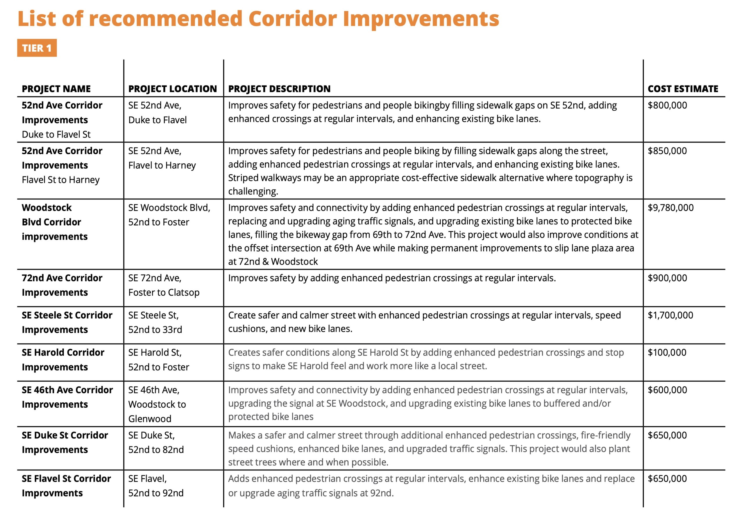
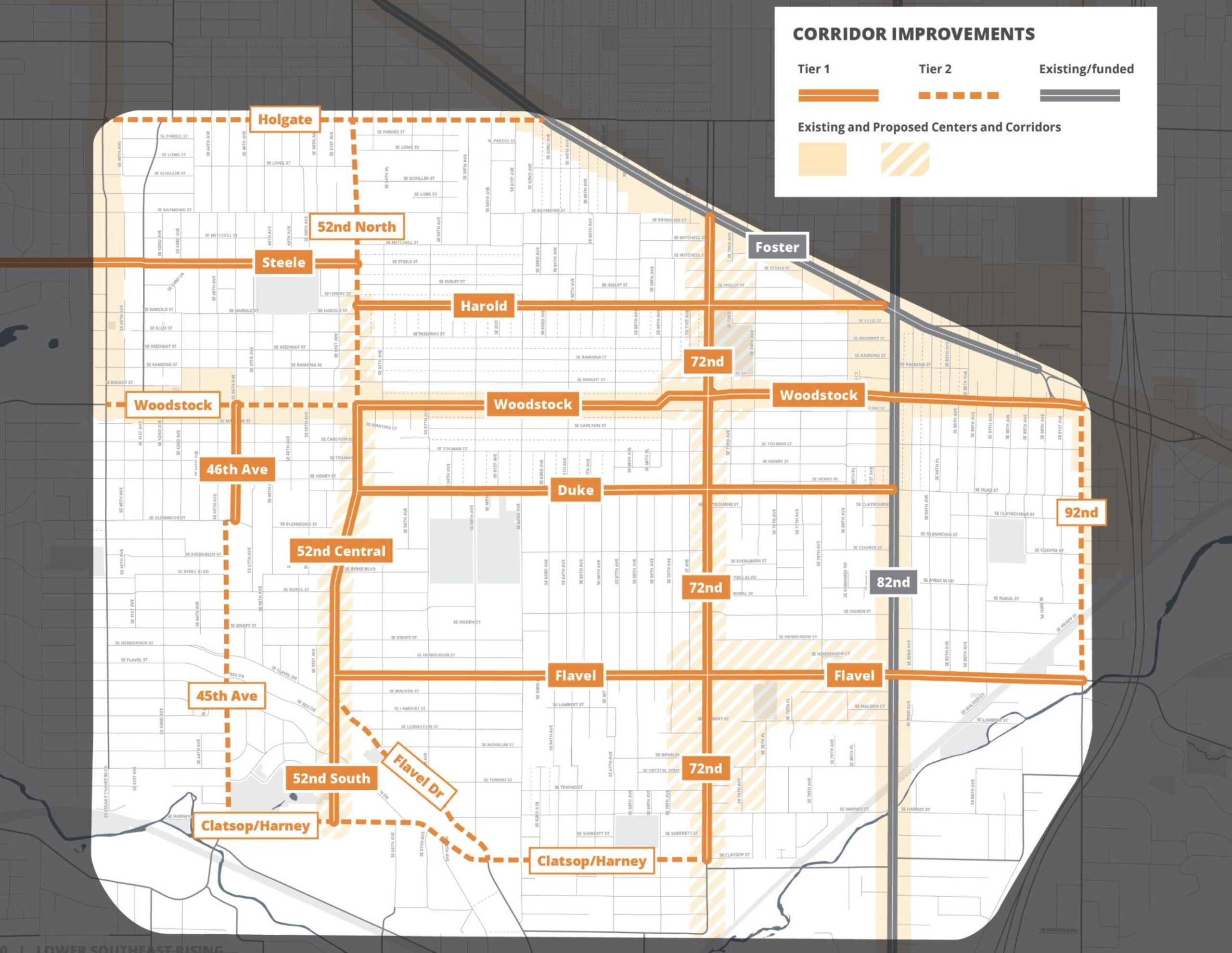
Like similar “In Motion” plans in other parts of the city, PBOT has recommended a set of transportation projects split into Tier 1 and Tier 2. One of the Tier 1 projects (estimated cost $800,000) would fill sidewalk gaps, improve crossings, and “enhance” existing bike lanes on 52nd Ave between Flavel and Duke. This section of 52nd is slated for repaving in 2025 — a project that “will be the key near-term opportunity” to make these changes a reality.
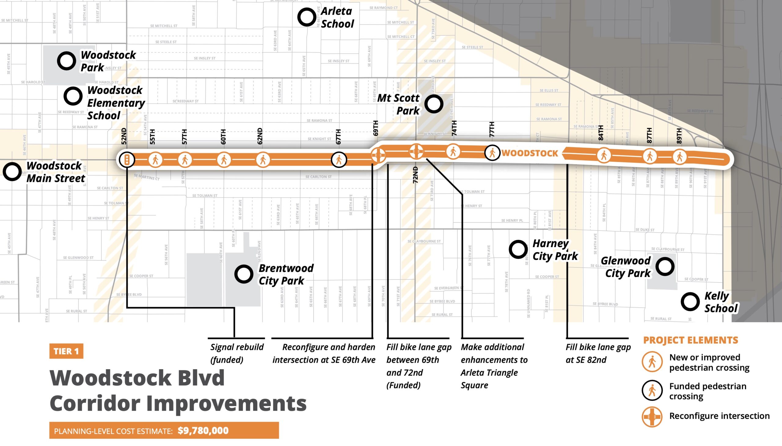
Another Tier 1 project is a $9.7 million upgrade to SE Woodstock between 52nd and I-205 that would tackle the dangerous off-set intersection at 69th, add protected bike lanes, and more.
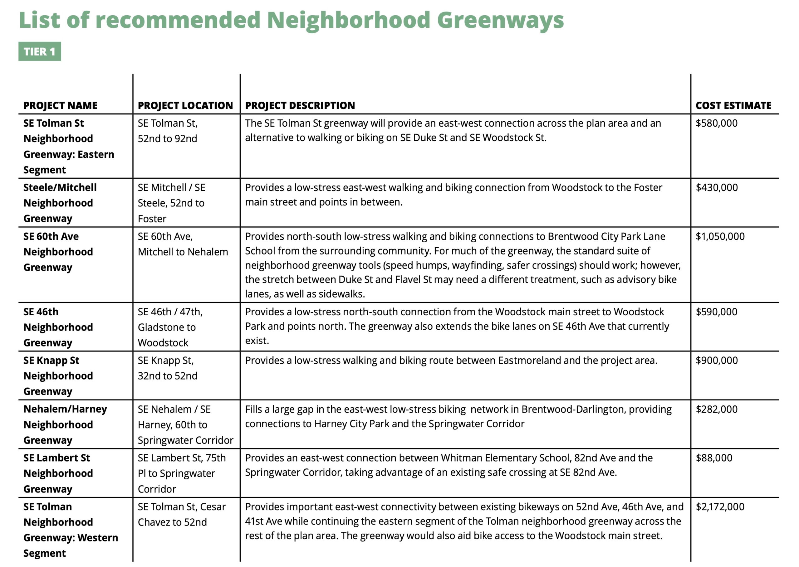
The list of nine Tier 1 corridor improvement projects have an estimated cost of over $22 million. The seven recommended Tier 1 neighborhood greenway projects — with new greenways on Tolman and on 60th playing starring roles — have a total estimated cost of $6.1 million.
The plan also makes recommendations for bus service expansions and includes details on how to fund and implement all the projects.
What’s next
The plan is currently in “discussion draft” form which is a final step to garner public feedback before the “proposed draft is released.” That’s expected to happen in August when there will also be a public hearing at the Planning Commission before a final adoption by Portland City Council. Comments on the current draft are being accepted through June 23rd.
This is a thorough and (thoroughly) exciting plan for a part of town that has been left behind for too long! Take time to check out the plan and share your comments. Get all the links you need to learn more and comment here.


Thanks for reading.
BikePortland has served this community with independent community journalism since 2005. We rely on subscriptions from readers like you to survive. Your financial support is vital in keeping this valuable resource alive and well.
Please subscribe today to strengthen and expand our work.
This is great news. Mt. Scott-Arleta, if Wikipedia is to be believed, had a population density of 8,600 people per square mile all the way back in 2010. I’m sure it’s even greater now. The access to transit, bike infrastructure, and neighborhood commercial is pretty good but compared to the density of the neighborhood it could stand to be much better.
“The access to transit, bike infrastructure”
I didn’t see anything about improved transit, and the new bike infrastructure is primarily greenways, which would not reflect much if any change from what is available today.
So… This sounds to me like developing a car dependent neighborhood.
As it stands now, I think Mt Scott-Arleta has fairly decent transit access. A few good buses (72, 14, 17) that run fairly often, plus the 19 and 71 that are due for service upgrades soon. Having 3 downtown oriented plus two crosstown oriented buses is more than most neighborhoods have at least.
In terms of density, I would broadly question that 9k people/sq mile is some impressive benchmark when the least dense parts of San Francisco are still significantly denser than that. Mt Scott is definitely a car dependent neighborhood for the most part now, but I think it’s got just as much hope as any other Portland neighborhood for breaking that mold
I get excited when I see aspirational plans like these but I have to keep my hopes tempered. With the city in such dire straits that it is considering an additional tax to fund basic transportation improvements (while it wastes millions elsewhere) I’m just not sure this will ever come to fruition. I have to chuckle when the city says things like: “The ultimate goal is to give people the opportunity to meet daily needs without having to drive” yet the businesses needed for this to become reality are getting robbed and vandalized regularly and even large retailers are choosing to leave the city because of crime/shoplifiting and dangers to their employees.
Incremental plans that reduce crime, addiction and homelessness should come before the Aspirational plans of wistful bureaucrats and incompetent politicians
If you mean Walmart, I guarantee the world’s largest retail company does not care about a few shoplifters. Big box stores are only designed to last 25 years or so. The Eastport Plaza store, which recently closed, was opened in 1998. You do the math.
Portland really needs to ditch the idea that multi-family housing only belongs on high traffic corridors.
YIMBYs/urbanists should ditch this too..
I think most YIMBY’s believe that anyone should be able to build apartments on land that they own. I mean, nobody made me the spokesperson, but that’s the impression I get from devouring YIMBY media all the time.
YIMBYs led the charge in Portland (both YIMBYs in city bureaus and YIMBYs in lobbying groups, such as, PfE/P:NW) to push for the classist centers and corridors multi-unit housing model. This is one of the reasons that many long-time renters have antipathy towards YIMBYS.
That’s not even remotely true. I’ve been involved in YIMBY groups for years, and pretty much everyone in that movement agrees that we should not have density restrictions anywhere. Centers and corridors was a model that only allows density in narrow areas, and is pretty much contrary to the whole YIMBY ethos.
Many Portland YIMBYs strongly supported this model as a way to upzone non-contiguously zoned plots along arterials/collecters (traffic sewers). For example, upzoning from low-density multifamily to CM along the arterial or to R1/CM1 a block over.
TJ, DK, MA and others functioned as boosters for this classist/racist policy by advocating for upzones along corridors. I repeatedly called them out on it but I don’t think YIMBYs give a #$% what tenant organizers think about them.
It also belongs in downtowns if it can be fit there. That’s it.
Along arterials in addition to downtowns is long obvious, and “along” may include sites adjacent to arterials on cross streets one-half to one block in. Done. Cross streets are a transition zone, and ideally should feature low-rise and open areas.
In previous community plans done over the years, it seems like a main motivation for focusing density on high-traffic corridors is that it avoids the opposition from residents that happens when low-density residential areas are up-zoned.
If a plan significantly upzones a traffic corridor, planners can claim they’ve created X hundreds or thousands of potential new residential units, which is true on paper, without nearly the opposition they’d get from adding that many potential units in low-density residential areas. So they get some potential added density with low opposition vs. more density with high opposition.
It seems Portland like their neighborhoods and don’t want them transformed by idealistic planners who have no real stake in the outcome.
“Neighborhood corridor” and “hub for commercial services with additional housing options” are planner-speak for limiting large housing developments to noisy, polluted, and dangerous arterial streets. Apartments are disproportionately lived in by people with lower incomes and fewer transportation options. But having access to public transportation shouldn’t mean having to live right on top of it. Upzone the side streets and legalize neighborhood retail to create truly walkable neighborhoods.
https://slate.com/business/2021/12/side-streets-upzone-apartments-houses-traffic.html
agreed, LA does this, protecting its interior neighborhoods and developing the boulevards with high density and transit, and LA is a mess.
YES!!!
I just want to point out that YIMBYs/urbanists played a major role in boosting and supporting Portland’s classist centers and corridors model. I won’t name names but I had strong disagreements with a who’s who of PortlandforEveryone/Portland:NeighborsWelcome organizers over their poorly-thought out and classist support for targeting rental housing to traffic sewers/urban freeways. It’s also exceedingly hypocritical to see prominent PfE/P:NW organizers suddenly start to criticize these policies without confessing to their earler support.
I wanted to log in and comment on this but your instance of wordpress seems to silently disallow commenting while ublock origin is running, which I need to do to keep my web experience sane. I thought you’d like to know.
Hi Andrew,
Sorry about that. I’ve notified our web dev to see if there’s a fix. Thanks,
FWIW, utilizing ublock’s site-by-site on/off feature has worked fine for me browsing BikePortland (=I simply have ublock toggled off for BikePortland). I too rely on ublock heavily to make the internet significantly less awful, but BikePortland’s ads are not intrusive or immersion-breaking, so I’m fine letting them through. Not to mention the additional financial support, however little the individual ads served to me provide in that direction.
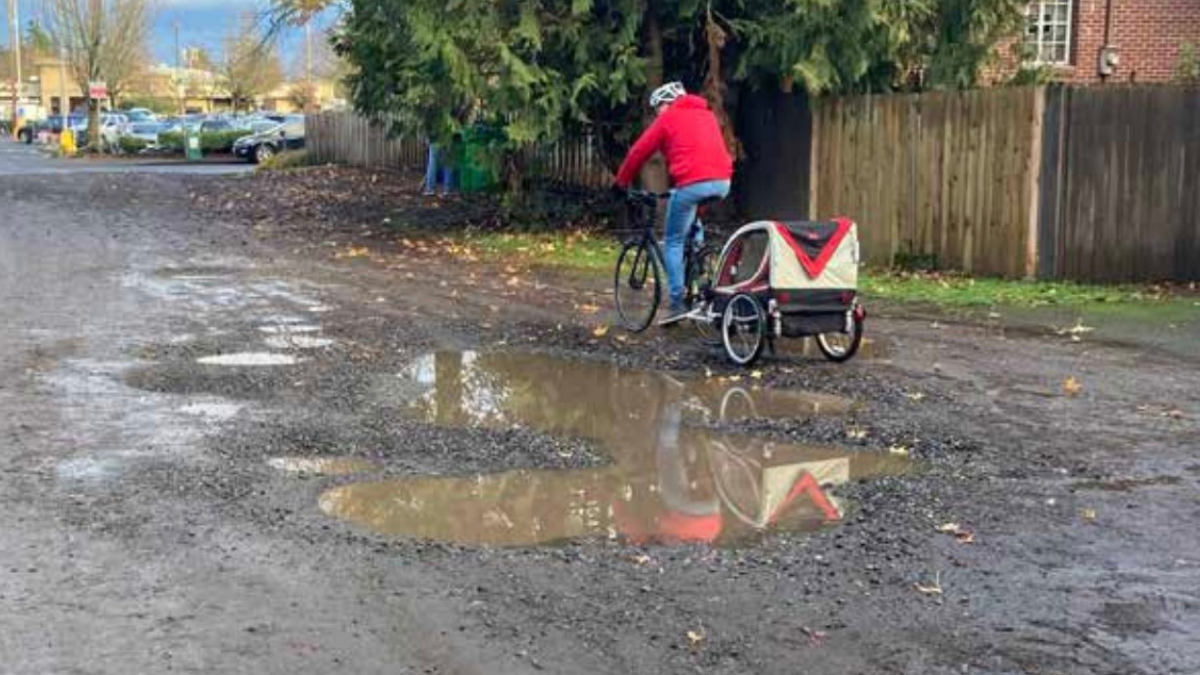
Is there any research about the relationship between potholes/gravel stretches/no sidewalks and car dependency? I ask because I could see this also running in the opposite direction (from what is i oiled in the article). To me, unimproved stretches are great for biking (sturdy bike, sensible tires) but not so inviting for those in cars,
.
Thoughts?
I’d say the size and frequency of potholes on our gravel streets in B-D is not conducive to biking (especially at night and in wet weather when the potholes become mud pits). Anecdotally, there are also fewer drivers on these streets, and I live next to one. I think the car dependency in Brentwood-Darlington is more due to distance to commerce and insufficient public transit options, rather than to prevalence of unpaved streets.
I agree with those sentiments, generally.
But at least in my experience potholes are a cinch to avoid/swerve around on a bike, but no fun at all in a car.
I just think we haven’t, collectively, really thought through how the make-ugly-potholes-and-sidewalkless-streets-go-away is a key step toward gentrification, which then predictably undermines all kinds of goals we (some of us) may have about equity and alternatives to fossil fuel transport.
Why not approach this straight out as an opportunity to make biking better, safer, more enjoyable, and leave the unimproved streets to discourage gentrification?
A relative who used to live off a truly decrepit street faced opposition by neighbors to the most basic improvements like gravel. The reason: such decrepitude, even hazardous to vehicle integrity, is highly effective traffic calming, and low-cost, too.
Some other aspects to consider: gravel roads can exacerbate asthma attacks. I believe there’s research on this but I’ll defer to others on this and just add perspective from lived experience. Have you ever tried pushing a stroller over heavily potholed roads? Or teach a child how to ride a bike in such a setting? I’ve done both. It’s a chore and not always comfortable or safe. Maybe it’s great for you to bike (if you’re a healthy adult riding alone) in such locations, but it’s a vastly different experience when you’re walking with a child in a stroller, or riding a bike with a kid in a burley), with cars sometimes veering dangerously close to you to avoid the worst potholes.