The Portland Bureau of Transportation will install two new advisory bike lanes this summer in Northeast Portland.
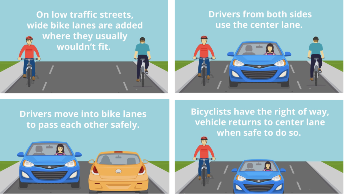
The bike lanes are “advisory” because drivers are allowed to enter into the lanes in order to safely pass each other — but only if there are no bike riders present. Since the design (below) also removes the center-lane stripe, it forces drivers to be more present and less entitled, thus slowing them down and leading to better safety outcomes. At least that’s the idea.
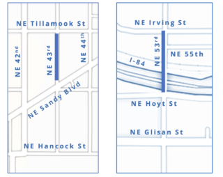
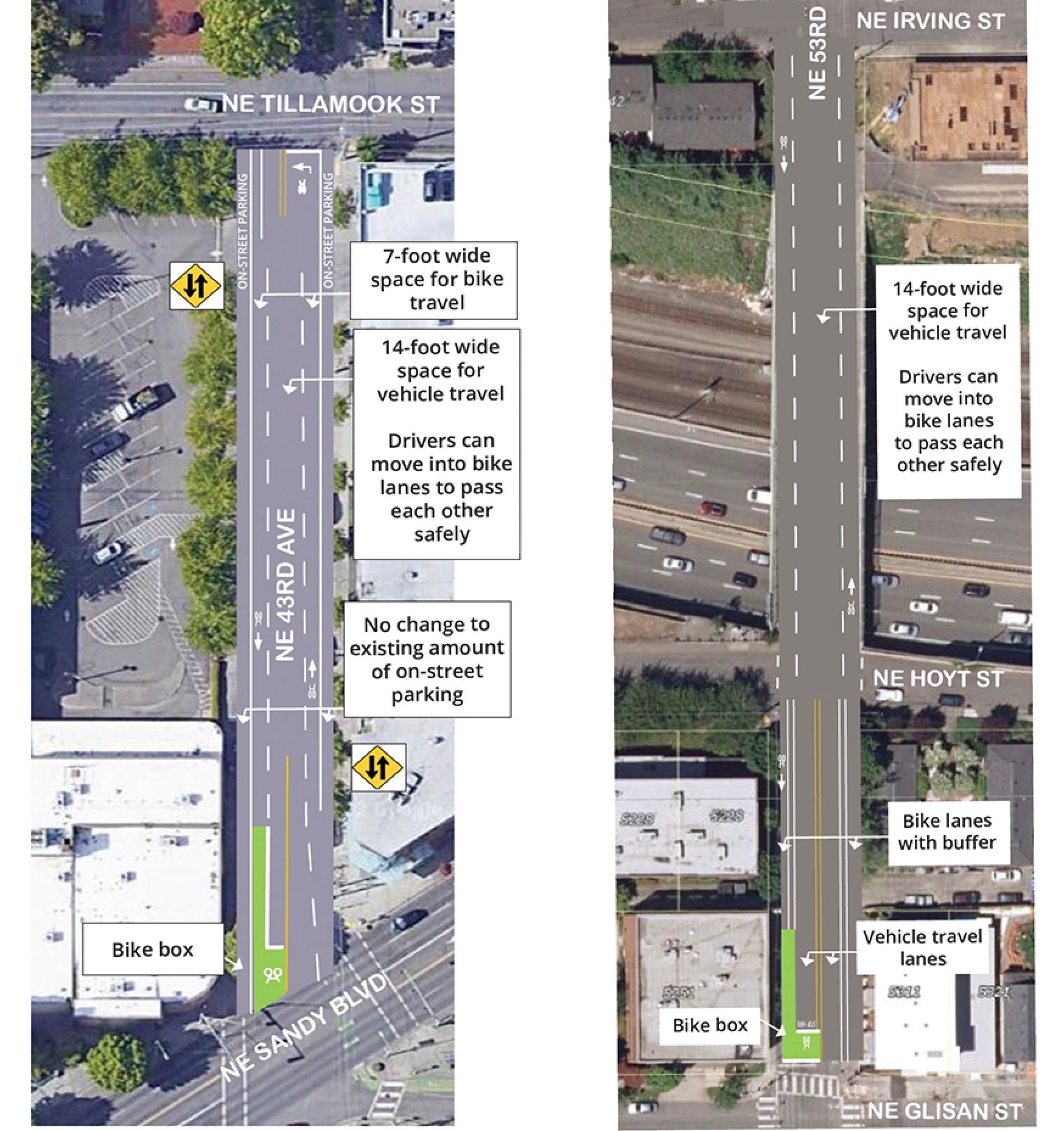
The advisory bike lanes (a.k.a. edge lane roads) PBOT plans to install later this summer will both be in Northeast Portland (above). One will be on NE 43rd Ave from Tillamook Street to Sandy Blvd, making it safer to get from Sandy Blvd and the Hollywood District up to the Tillamook Neighborhood Greenway. The other will be on NE 53rd Ave from Hoyt to Irving Streets, easing the commute across the I-84 bridge and adding an enhancement to the 50s Bikeway.
These advisory bike lanes will also come with two new bike boxes at 53rd and Glisan and NE 43rd Ave and NE Sandy Blvd. “Bike boxes” are the green pavement markings at intersections allowing people bicycling to stop in front of people driving cars at red lights. This makes it so people in cars are aware of cyclists and won’t make a right turn across a bike lane, potentially colliding with someone on a bike.
Advertisement
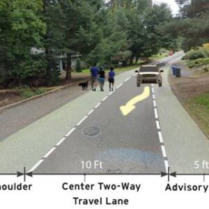
Along with European cities, advisory bike lanes have been used in some places in the United States, with Minneapolis serving as a notable example, and have had positive safety results. On PBOT’s website they cite research on roads with advisory bike lanes from 11 U.S. cities that over eight years that found a 44% overall reduction in crashes compared to traditional 2-lane configurations. They are used on narrow streets with low driving volumes and low speeds, and allow for wider bike lanes than would normally be able to fit on such streets.
This type of bike lane is something PBOT has expressed interest in before, since as far back as 2009, but they appear to have only made progress in two locations so far: on NW Marshall (between 12th and 14th) and SE Caruthers (between SE Grand and the Esplanade path).
Already a staple in The Netherlands and considered a much stronger signal of bicycle priority than the ubiquitous sharrow markings PBOT already uses on greenways, this type of treatment could become a way to retrofit low-volume streets in a way that encourages more bicycle use.



Thanks for reading.
BikePortland has served this community with independent community journalism since 2005. We rely on subscriptions from readers like you to survive. Your financial support is vital in keeping this valuable resource alive and well.
Please subscribe today to strengthen and expand our work.
totally agree. Similar to how the NW Marshall from 12-14th lanes feel with the concrete over the pavers. I always liked this section as it states that the default is BIKE in these areas, and if needed a car can occupy.
Wow, this and a bazillion other wild “pilots” are a reason why accidents happens. We need clear, concise, and consistent infrastructure. If not then we are creating disaster but feeling good about it.
Also, how much more does the city need to do “to encourage bike use?” If it hasn’t happened now, when will it?
If they want to encourage bike use, how about a safe place to lock up your bike? Maybe prosecute bike theft? Or perhaps enforce traffic laws? Can we bring back license plates on all cars?
How is it that we are supposed to get to this effective, safe “consistent infrastructure” if we (by that I mean PBOT etc) don’t try out different approaches? And give them time to prove/disprove their worth.
Anyone who watches the Not Just Bikes channel on YouTube knows what safe, effective bike infrastructure looks like. It does not need to be rediscovered or iterated upon. It is there to be copy-pasted.
The reason we get all these experiments is because PBOT wants the effectiveness of successful bike infrastructure without the actual work. Maybe this white stripe or this green crosswalk will be the magic paint that makes drivers behave, instead of the many diverters, raised crosswalks, and other pedestrian-first infrastructure we need to make driving less convenient than biking.
There is only 24′ of pavement on NE 53rd Avenue over I84. Advisory bike lanes make good since here when the alternative is doing nothing because it would be too expensive to completely rebuild the overpass.
That was my first thought, but then I remembered the residential street right in front of my house. No bike lane, but it’s a narrow street with street parking on both sides … leaving room for just one car to drive through at a time.
Drivers have had to do the “pull to one side to let the oncoming car pass” dance as long as this street has existed — so going back to the 1940s, if not earlier. I haven’t noticed any accidents happen, and I’ve been here a few decades now.
So I feel pretty comfortable that this skinny street plan can work.
We have 20 variations. If inconsistent is a vibe then cool. I just don’t want to mix bikes and autos for kicks. I’d rather play with death doing something enjoyable.
Doug, why do you spend so much of your time trolling the comments on a bike blog if you hate cycling so much? Why don’t you go do something you love instead of giving other people a hard time for something they love?
Doug is not a troll. Please don’t use that insult here. Just because someone has a different perspective than you do, doesn’t make them a troll.
What did you perceive be trolling in my comment? Also, I ride many places around town and bike commute to work the days I go to the office. I’ve been frequently biking for the past 10 years in Portland and 5 years in the Windy City before that. At least 19 people agreed with my assessment. What did you come to this comment section to offer? I’ve also been part of NA transportation committees for over 4 years and PBOT work groups. Not that I need to qualify myself to someone I don’t even know but falsely saying things about what I like or don’t like requires context.
Hmm
They should do these markings on all “shared roadways” and greenways
Hard disagree. On greenways I enjoy taking the full lane and riding beside my friends and loved ones, instead of being forced into a single-file line in the gutter.
To implement these would be to give more space to cars than they deserve on greenways.
Thats a fair point, theres no real greenways by me but instead what pbot calls “shared roadways” that look like this https://www.google.com/maps/@45.480565,-122.7165472,3a,67.7y,94.93h,83.08t/data=!3m6!1e1!3m4!1sMRN9G68CdrFpFmmyBPpFCA!2e0!7i16384!8i8192 where such implementations would take space from cars.
In the Netherlands, bikes aren’t required to stick to the bike lane; they can bike in the vehicle lane.
In the Netherlands they would never create a non-traffic-controlled advisory bike facility adjacent to a busy commercial district and an SUV-centric hyper-market.
It took me about 2 seconds to find an advisory bike lane in the Netherlands in a similar context to 43rd Ave:
https://goo.gl/maps/T8Kt2Qya3asngCMUA
The difference is that in the Netherlands there is a high quality bikeway on the adjacent arterial. Unlike Portland, they recognize that shared use facilities play a supporting role in a network anchored by separated facilities.
This is what a grocery store looks like in central Amsterdam. A small part of one block with no dedicated parking:
https://www.google.com/maps/place/Marqt+Haarlemmerstraat/@52.381204,4.8898278,3a,90y,218.28h,79.7t/data=!3m6!1e1!3m4!1stGZOsfwJR8dS-0WLndi1XQ!2e0!7i16384!8i8192!4m11!1m2!2m1!1sgrocery+store+amsterdam!3m7!1s0x47c609cec5f19f4b:0xe1228ea763fd96f0!8m2!3d52.3811768!4d4.889697!14m1!1BCgIgARICCAI!15sChdncm9jZXJ5IHN0b3JlIGFtc3RlcmRhbVoZIhdncm9jZXJ5IHN0b3JlIGFtc3RlcmRhbZIBDWdlbmVyYWxfc3RvcmWaASRDaGREU1VoTk1HOW5TMFZKUTBGblNVUlJkblpIWVRkUlJSQUI!5m1!1e3?hl=en
The Hollywood Whole Foods hypermarket takes up an entire large block, has a massive parking lot, and has very high levels of car traffic (hence the preservation of parking on 43rd). This type of SUV-centric commercial monstrosity would not be allowed adjacent to a bike facility that is only compatible with low levels of vehicle traffic in the Netherlands. As you rightly point, in the Netherlands there would be a protected facility.
My apologies. I didn’t realize the street in question was an arterial as opposed to a collector.
I ride that section of 53rd often being passed on the bridge isn’t really a problem besides the occasional driver passing unnecessarily just to turn on the other side of the bridge.
The real problem in that area is after the bridge where parked cars make the space to pass too narrow and impatient cut through drivers that try it anyway. Also there’s a handful of neighbors there that really don’t like those orange local access only barrels. The plastic wands that have replaced the one at Halsey are pretty disappointing. I was really hoping for something harder to move or destroy like the planters on Salmon. My assumption is there wasn’t enough space for delivery drivers, garbage trucks and emergency vehicles to make the turn. Hopefully they’ll put something more permanent on the Irving side.
Also a frequent 53rd rider… north of Irving the street has no pavement markings now. I fail to see how this will make things “better”. At least there.
?
There was a ND post where someone living on the NE side of the 53rd (& Irving?) intersection was all upset about losing parking now that it’s getting daylighted by PBOT. It became apparent that they had a driveway & garage, lived on a corner, and thus still had ample parking options. And yet they kept going on about property values, their rights, etc. a few people pointed out the improvements for overall public safety, but they fell on deaf ears, sadly.
Sounds like NextDoor.
Ugh. Sounds like someone on the internet said something bad again.
FYI, the 2009 Fundamentals of Bicycle Boulevard Planning and Design handbook written by Lindsay Walker, Mia Birk, and Mike Tressider (all Portland folks at the time), recommended this treatment for bicycle boulevards.
Awesome! I like this a lot, but also as somebody else commented: the differing pavement colors would really state that these are bike lanes primarily.
Also: isn’t this section on 43rd already advisory? I always wondered what the hell was happening with this striping configuration…
Not a fan of the idea of advisory lanes that are placed in the door zone. Seems like on 43rd the right solution would be to remove some parking and/or make the street 1 way for motor vehicles.
Ya the bike lanes on 43rd are pretty much unusable when Whole Foods is open. I can’t imagine this treatment will be any better.
Agreed — given that 43rd is right next to the car-centric 42nd and we’re only talking about a block, I don’t understand why they wouldn’t just make this road one-way.
53rd over the bridge I get, and seems like an improvement. But 43rd seems like a dumb compromise with drivers who have many other options.
PBOT wants to downgrade 43rd and Grant Place from Neighborhood Greenway status so that drivers can drive without being inconvenienced by those annoying and entitled bikers on NE Grant Place. Apparently PBOT believes drivers have “major destinations” to visit, unlike those bikers.
https://bikeportland.org/2021/03/09/too-many-cars-on-tillamook-greenway-spur-talk-of-re-route-327590
I feel like I would rather just take the lane then rely on cars to pass each other safely on one lane roads. I understand the intent, however, I am just afraid drivers will need to look for cars in front and bicycles behind (to pull into the bike lane) when wanting to pass each other going opposite directions. Instead of just looking ahead and seeing the bicycle has taken the lane and no cars or oncoming bikes are approaching.
This is going to be a huge improvement for 53rd. I think the new southbound configuration is going to push a lot of hospital traffic off of 53rd, as there will now just be one southbound lane. During the afternoon commute, most vehicles turn south onto 53rd and then left onto Glisan. I expect this new southbound lane to be completely jammed up between 3 and 5:30pm now. Expect hospital traffic to now go south on 52nd or to continue east on Hoyt. If you are riding north on 53rd, you definitely need to watch for people darting blindly east on Hoyt, their view blocked by stopped cars on 53rd.
I predict that the “advisory bike lanes” will lead more motorists to believe (or claim to be confused if ever confronted) that all bike lanes throughout the city are advisory. These motorists will choose to use “actual” bike lanes for passing. You know, such as when they are being slowed down by a motorist driving too slowly (i.e. obeying the speed limit.)
I hope I’m wrong, but I fear the outcome.
In Portland all bike lanes are advisory lanes.
I love how the illustration shows advisory bike lanes next to side walks, while the Portland reality will be advisory bike lanes in the parked car door zone. No thanks.
I’m sick of having to ride in experiment after experiment while drivers get clear, consistent infrastructure.
This seems no different from streets where drivers “dip into” bike lanes to pass someone turning left.
It’s actually normalizing the idea that cars may use the bike lane anywhere to pass other motorists.
PBOT will literally try anything besides evidence-based infrastructure that slows motorists down.
Just curious: What is the “evidence based infrastructure” that would get bi-directional auto traffic across I-84 @ 53rd?
That term seems so meaningless that it doesn’t mean anything, yet people keep using it as if it means something.
I don’t have the dimensions of the road in front of me but extending the sidewalks and turning them into MUPs would be my guess.
>That term seems so meaningless that it doesn’t mean anything, yet people keep using it as if it means something.
It means something.
The sidewalks are already pretty wide, but I don’t want to mount the sidewalk for one block of travel (nothing stopping you from doing that today, but I’ve never seen a cyclist do it). North of the bridge, it turns into a very narrow neighborhood street, and the sidewalks are standard width. I’m a big fan of these advisory lanes on 53rd.
I’d rather mount a sidewalk (I actually have to on my daily commute), than ride into oncoming traffic towards some motorist who isn’t paying attention.
PBOT could build the infrastructure on either side to make the transition to the raised lane smooth and safe.
No doubt… so what does “evidence based infrastructure” mean? Why is this proposal not it, but widening the sidewalks to use as MUPs make make it so?
Will there be other signage to instruct drivers about the new traffic pattern? The signs pictured don’t convey anything other than the road is for two way traffic.
I’ve stared at the 43rd avenue configuration and wonder how it’ll play out with a cyclist and motorist approaching Sandy at the same time while the parking area is being utilized? It’s ambiguous at best. Assuming both people have the best intentions and are without anxiety, impairment or distraction, I still see an opportunity for a collision.
It’s weird in the NE 53rd graphic that PBOT blotted out the sidewalks on both sides of the bridge. Clearly (but not according to the graphic) the sidewalks will remain, but it’s a sloppy mistake that makes it look like PBOT lacks awareness of pedestrians.
https://www.google.com/maps/@45.5270686,-122.6089291,3a,23.1y,9.47h,87.34t/data=!3m6!1e1!3m4!1s23Q871fub7Mq5GoM7x995w!2e0!7i16384!8i8192
I have to say, this seems like a pretty neat concept. According to PBOT’s illustrations, bicyclists magically disappear when a car wants to drive in their lane, then reappear once the car has passed and shrunken.
It’s the Oregon Vortex of road design.
How is this any different or better than sharrows?
Based on the current Netherlands (and some historical use in US) use on narrow streets without parking these are fully marked dashed bike lanes vs spotty sharrow stencils. Sharrows, as implemented in the US, often visually ‘disappear’ for most drivers due to their less infrequent spacing (than ideal or as traditionally used in Europe when Oliver Gajda and I were cycling around Paris in 2003 and saw them initially in use as a network treatment). A dashed line is more difficult to “miss”. Now the issue of enforcement is a separate but important issue.
I’m guessing the Netherlands isn’t using these treatments to preserve car parking like the 43rd design proposes to do
https://www.google.com/maps/@52.0444416,4.3889639,3a,75y,301.33h,91.62t/data=!3m6!1e1!3m4!1sVVfjyPrJ1WZi6XWzdKY-Tw!2e0!7i16384!8i8192!5m1!1e3?hl=en
That’s an incredible example. In about the same right-of-way width, what you’d see in Portland would be a standard two-way street, with parking on both sides, and narrow sidewalks made narrower by street trees–almost 100% paving and concrete.
Instead, there are two sidewalks–one VERY ptrotected, the other with some large curb extensions, a wide landscaped area, and large trees that don’t interrupt the sidewalk; plus two bike lanes, and still parking on one side, and still two-way auto traffic.
The possibilities sure open up when you eliminate one traffic lane and one side of on-street parking, and interrupt the other side of parking with curb extensions and street trees.
Resharing my 2009 Bike Portland post on this topic, in article link, to address some of the BP reader questions:
“Sharrows are a similar tool for blended / shared lanes…but they are typically found on wider streets (>22 feet). Streets with advisory bike lanes are among the narrowest bi-directional street type.
As the article mentions…this is becoming a very common bikeway facility type in the Netherlands and in Europe as a whole. The key is that is provides a visual clue for bike access on roadways that were designed and built too narrow for separate lanes.
Typically in the Netherlands it is found on urban low speed (19 mph or less) streets that are about 18 feet wide. The bike lanes are 4 to 5 feet in width with the center bi-directional shared car lane is 10 to 12 feet wide. (I have seen it on streets as narrow as 16 feet though.)
The function of this facility is to promote bicycles having a space (drivers to expect them there) and for drivers to proceed slowly and dip into the cycle lane as needed – they may even have to slow and wait behind a cyclist if there is not room to pass. Additionally I have seen bike riders ride side by side just outside of this lane.
The dashed line allows this for bicyclists as it does for drivers…to dip in to each other’s lane as is needed. [Like a continuous center turn lane.]
I do not understand why the institutional concern for finding an exact reference to this type of facility, since it already exists in practice (queuing streets) and the dashed bike lane is in the MUTCD. The key is to find streets where it would work with greater safety than the existing conditions.
Both Michael Ronkin and I have been promoting this tool for use for many years. (Happy 60th Birthday today Michael!)
In my low cost proposal for its use on old Evergreen Highway in Vancouver (not yet adopted) – which would have been more similar to the rural use of this type of facility in Europe – I would have added the stenciled curved arrows found in center turn lanes for arterials – that is another similar facility we have that the MUTCD allows this shared lane use by cars.”
[2022 Update: Michael Ronkin is still alive and kicking in Europe…he is planning a slow long distance bike ride for this June!]
San Diego did this with some horrible results.
Installed one week. Removed the next.
https://m.youtube.com/watch?v=Tyn8mDne7G4
https://m.youtube.com/watch?v=C2VXilmWlwE
Couple of the local news reports from San Diego regarding this.
I’m not thrilled at all with 53rd. I frequently travel 53rd south across Glisan in the afternoon and usually swing well to the center of the bridge due to the terrible sight lines for traffic coming east on Hoyt, due to the safety fencing at the corner. If I’m “forced” to ride to the far right, it’s going to put me in a much less visible position.
I also worry about traffic backing up past Hoyt, but that may not be an issue. What I can see is right-turning traffic getting impatient and using the bike lane/buffer zone to cut past waiting left turn cars. Also not looking forward to drag racing the occasional car also crossing Glisan going south.
There’s a lot more to the cited study than mentioned. A good percentage of the EMR’s studied had an increase in crashes after implementation, and a lot of the ones in the US are in rural areas that are very low traffic. I ride 53rd often, that bridge is so short I’m not sure this is going to make a difference. The problem here in Portland will probably be when two drivers are head-on and there are bikes “in their way”. I’ve seen near-zero compliance when a driver has to yield to… well, anyone else.
Need an “L” elevated bike path east to west from gateway to Rose Garden with exits at Hollywood and 60th, max line structures in place to compliment an elevated bike path. ?