
Last week we shared the active transportation and regional trail projects the city of Portland is asking Metro to fund through its 2025-2027 Regional Flexible Funds Allocation cycle.
But Portland isn’t the only city in the region vying for a chunk of the $61.25 million up for grabs. What projects do other parts of the Portland metro area have up their sleeves?
Below are a few interesting projects from beyond Portland’s borders that caught our eyes…
Willamette Falls Drive Multimodal Project (City of West Linn)

Amount requested: $3,362,984
Total project cost: $4,100,000
This regionally significant multimodal and safety improvements project will greatly enhance bike, pedestrian, and transit mobility along Willamette Falls Drive between 16th St. and Ostman Rd. The proposed project will result in the continuation of uninterrupted, grade-separated protected bicycle paths and sidewalks with a consistent two lane vehicle cross section. The project is focused on multimodal safety and largely fills a gap in this regional bike corridor that parallels I-205. In addition to safety improvements, the project will improve equitable access to dedicated bike and pedestrian facilities providing a direct connection to the City’s Historic Main Street business center.
Advertisement
Westside Trail Bicycle & Pedestrian Bridge (Tualatin Hills Park & Recreation District)


Amount requested: $1,907,500
Total project cost: $2,725,000
The Westside Trail Bicycle & Pedestrian Bridge will complete a major gap in the regional active transportation network and provide trail users a safe, dedicated crossing of U.S. 26. As identified in Metro’s 2014 Westside Trail Master Plan, a bridge over U.S. 26 “is a crucial link, without which intersecting Westside Trail sections would not be functional.” The proposed project will complete design and engineering for the bridge, building on a feasibility study that was completed in 2021.
The trail design includes a 12‐foot‐wide path with 2‐foot‐wide shoulders, conforming to the regional trail standards in THPRD’s 2016 Trails Function Plan and in alignment with Metro’s Multi‐Use Path standards outlined in Section 4.3 of the Designing Livable Streets & Guide. Key ADA accessibility guidelines such as a running grade of less than 5% and a minimum cross slope of 1% are included in the design. The trail design was developed to provide safe and easy movement, safe and convenient trail crossings, wayfinding signage, and access for ongoing maintenance. The project will be a marquee for the Westside of the Metro region as it will be highly visible from a point on U.S. 26 where more than 148,000 vehicles travel daily.
Beaverton Creek Trail (Tualatin Hills Park & Recreation District)


Amount requested: $1,774,575
Total project cost: $6,093,600
The project will include final engineering, permitting and construction of a 1.5‐mile, 12-foot wide regional trail segment which will provide a critical and direct connection to transit, employment, commercial centers, and existing THPRD facilities.
Currently only on‐street routes exist in the project corridor for bicycles and pedestrians. These routes are undesignated, provide out‐of-direction connections and create conflicts between motorists and bicycles/pedestrians. The project will create an east‐west off‐street transportation alternative
Allen Boulevard Complete Street Plan: SW Murray Boulevard to SW King Avenue (City of Beaverton)

Amount requested: $723,670
Total project cost: $806,500
The Allen Boulevard Complete Street Plan project will undertake a planning process to identify transportation investments with community input and engagement in alignment with the City’s adopted Context Sensitive Design policy. The project will develop a plan to create a multimodal corridor that prioritizes mobility and access for people with a range of needs and physical abilities. Design alternatives will consider wider sidewalks with street trees, pedestrian crossing treatments, protected bike lanes, improved transit stops, and street lighting. The project will also consider new traffic signals, signal timing changes and transit signal priority to help keep buses on schedule. The roadway’s existing constrained right of way will prompt the project to explore right of way acquisition, as well as narrowing travel lanes and a three-lane cross-section.
Advertisement
Clackamas County – I-205 Multiuse Path Gap Refinement Plan

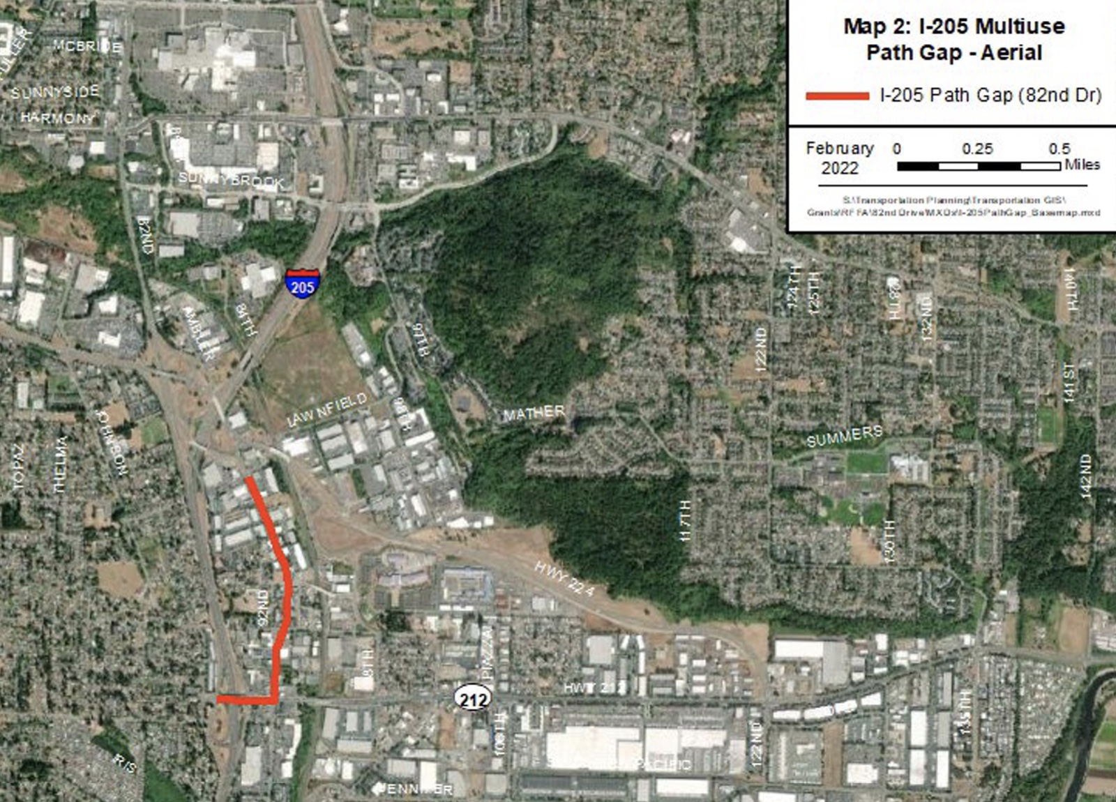
Amount requested: $935,884
Total project cost: $1,032,000
The I-205 Multiuse Path (205 MUP) provides a near continuous off-street facility from Vancouver, Washington to Gladstone with the exception of a one-mile gap between Hwy. 212 and Hwy. 224 in Clackamas County. This project will develop a community-backed design solution for a preferred route within the one-mile gap in order to facilitate non-vehicle transportation and improve safety and accessibility.
Developing a solution for the 205 MUP will fill a gap in regional trail network and provide connection to the Springwater Corridor; Marine Drive MUP; Trolley Trail; new Sunnyside Road cycle track and Sunrise Multiuse Path.
Preliminary design solutions include: One-way separated bicycle lane on each side of the street; 6-foot ADA compliant sidewalks with upgraded ADA compliant curb ramps throughout project area; enhanced crosswalks with RRFFB at Jannen Rd and Clackamas Ave; a 7 foot buffer for transit amenities, landscaping, intermittent swales and bicycle parking throughout the corridor.
City of Gresham – NE 162nd Avenue Complete Street

Amount requested: $7,316,079.52
Total project cost: $8,153,437.56
The project will construct continuous and ADA-compliant sidewalks, curbs, curb ramps, and buffered bicycle lanes from NE Glisan Street to NE Halsey Street. Improvements at the NE 162nd Avenue and NE Holladay Street intersection will include construction of sidewalks, ADA-compliant curb ramps, signal backer plates and more protection for bicyclists at the intersection. To support access to transit, the project will construct a Rectangular Rapid Flash Beacon crossing at NE Holladay Street to access the bus stops adjacent to the new affordable housing constructed on the Albertina Kerr campus.
City of Happy Valley – Clackamas River Trail


Amount requested: $666,174.60
Total project cost: $2,616,175
The Clackamas River Trail will construct a new, 1,450-foot regional trail along the Clackamas waterfront. This ADA-accessible trail will (1) anchor development in the brand-new Carver Waterfront District, and (2) forge an interim solution to the bike/pedestrian system gap on OR 224, improving access to TriMet Line 30.
— You can find all 29 project proposals here.


Thanks for reading.
BikePortland has served this community with independent community journalism since 2005. We rely on subscriptions from readers like you to survive. Your financial support is vital in keeping this valuable resource alive and well.
Please subscribe today to strengthen and expand our work.
Yes to the Westside Trail bridge over 26! There are currently no safe and low-stress crossings of 26 between the Rock Creek Trail and the Sunset Transit Center. That’s a huge distance! Would be a real game-changer and make it feasible for those who live to the north of the highway to get to the many businesses and employers on the south side of the highway by bike.
It’s less relevant to me based on location, but that Willamette Falls Drive project looks incredible too. Hope these two in particular get funding!
Anyone else suspicious that the City of Gresham will just use the project funds to justify an expansion of 162nd to 4 travel lanes? It’s clear to me from the design of the intersection at NE Halsey that 4 lanes is their intended final design.
What about the Allen Blvd overpass over the 217 freeway? No funding or priorities from ODOT?
The mythical bike lane idea itself on Allen Blvd is listed in the Beaverton city planning docs as “>5 yrs” away just to even consider it. I don’t think it is really a “priority” for anyone.