
(Photos: Jonathan Maus/BikePortland)
A key to a vibrant waterfront in Portland’s central city is to make sure people not using cars can use Naito Parkway safely and efficiently. Two major projects underway take massive steps toward that goal. In the last several months the Portland Bureau of Transportation has made exciting progress on their South Naito Improvement project (south of Hawthorne Bridge) and the Better Naito Forever project (north of the bridge).
According to an email from PBOT this morning, the SW Naito project is “substantially complete.” There’s just one lingering issue with an asbestos-coated water line between SW Harrison and Market that needs inspection from the Water Bureau. Once that happens, PBOT expects to do final paving in spring 2022. On Better Naito Forever, PBOT expects the project to be “substantially complete” by the end of this month! “Crews will return in the spring to plant additional trees, install planters, and install permanent striping,” said PBOT Capital Projects and Communications Coordinator Hannah Schafer.
Both projects will result in bike lanes that are physically protected from other lanes. They also come with new and safer crossings for vulnerable road users, less space for drivers, a new sidewalk in Waterfront Park, major investments in signals (including a bunch of bike signals), and more. Beyond the project elements themselves however, I’m most excited about how these new links will build connections to other parts of the bike network — like PBOT’s recent work on the Flanders bikeway, SE Hawthorne Blvd, Naito north of the Broadway Bridge, new protected lanes on SW/NW Broadway, and so on.
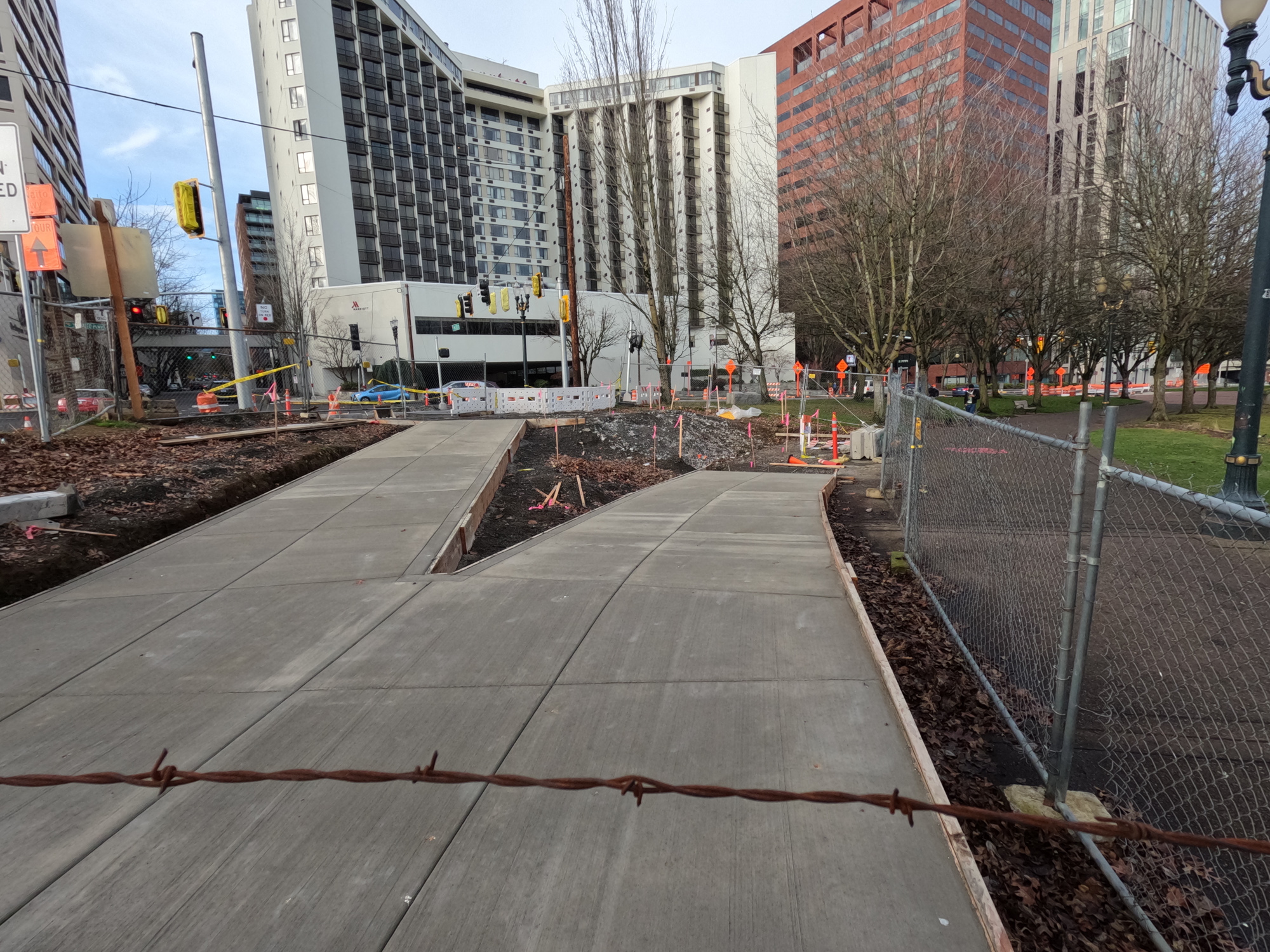
I recently biked from SW Market to NW Couch and snapped some pics to give you a sense of how it’s all coming together. The photos below will start at Market and go north to Couch. Please note two things: Both of these new bikeways will have two-way bike traffic on them and the projects are still not complete, so please obey all work zone cautions and signage:


Advertisement


Advertisement


For more details on each of these projects, click our archive tags below. Also see their respective project pages on the PBOT website: SW Naito and Better Naito.
Much excite! Stay tuned!


")

Thanks for reading.
BikePortland has served this community with independent community journalism since 2005. We rely on subscriptions from readers like you to survive. Your financial support is vital in keeping this valuable resource alive and well.
Please subscribe today to strengthen and expand our work.
having watched this thing for the past year, I think PBOT should do these projects in ‘phases’ where they can open sections of them and call it done before the entire project is done. This delay has been incredibly frustrating. There’s no reason we couldn’t have had at least half (if not 90%) of it open the entire time
Until you consider the efficiencies (and thus cost savings) associated with the construction companies mobilizing and implementing in a logical and coordinated manner. Yes, you could do phases, but it would cost a lot more.
Exactly. It’s much better for a contractor to stretch their specialty work across an entire project area at once. It could technically be done in stages but that would ultimately mean fewer overall projects as budget will be sucked up to do the phased work.
For capital projects yes. But if Portland wants to have an influence on modal share, it will have to grapple with making effective use of its budget via interim projects with bollards and semi-permanent materials. Naito’s great, but with the same money and planters etc, PBOT could add a number of miles of PBL to SE 7th, and NE Broadway/Weidler, for example.
That’s pretty excellent! I would like to see the curbs painted to increase their visibility
I’m guessing one of the last things the contractors will do is install the ‘delineators’ (plastic posts) and reflectors on the curbs as required by PBOT (check out Rosa Parks for example)
This will certainly be nice to have at the waterfront and beyond. Unfortunately, some of the portion south of the Hawthorne Bridge is not wide enough for two people to ride abreast; this is a big missed opportunity. And, the flow they seemed to have planned at the Hawthorne Bridge on-ramp going north toward the “Better Naito” portion is convoluted and could present serious challenges, especially for all those tourists who will be using this infrastructure. There just seems to be lots of extra (and costly) concrete that didn’t need to be there. Seems to me that had they closed that on-ramp to car drivers we could’ve had a much more open, more intuitive and less costly section of the bikeway.
I wish they’d routed the Better Naito path under the bridge east of the ramp, removing any need to cross it. Only negligibly longer, and would have completely removed this conflict.
One thing I think we should takeaway is how quiet and serene Naito has become without the traffic during construction. Also closing Naito Parkway completely to cars for the last year has proved as a form of pilot: we could look at having no cars on Naito at all (obviously except for emergency/event loading).
My sentiments exactly. I was in Cologne Germany over the summer and I loved how they had a waterfront park like ours with art installations and pathways, but next to that there was a wide outdoor seating area for adjacent bars and restaurants. That could easily fill the remaining three lanes of Naito Parkway. They also buried a roadway beneath it to achieve that, but they didn’t have any parallel roadways like there are here in the central city (1st Ave, 2nd, 3rd, 4th, etc).
Don’t get me wrong, I LOVE this project! Let’s take it up a notch and consider a Phase II that removes the traffic here. Keep these improvements and make it a truly transformative part of the city for walking and biking.
Not sure the past year is really the best study period for this. Downtown is on life support, and most workers are still remote. How are those bike counts on the Hawthorne bridge looking compared to 2019? Would it be fair to take that data and draw conclusions on future bike commute levels?
City of Portland/PBOT could also do a timed Naito closure or better yet, whole sections of downtown. In Florence Italy, as an example, the downtown core is close for cars/trucks (except taxis/buses/residents) during business hours. All deliveries are done before 730am or after 8pm. This area is termed a restrictive traffic zone.
https://www.visitflorence.com/tourist-info/driving-in-florence-ztl-zone.html
In other words, it’s the Waterfront Park sidewalk and bike lane past the Hawthorne Bridge that we’ve always needed.
The rest is mostly fluff.
In ten years, we have retrofitted our streets with protected lanes (many still full of mushy unswept leaves). There are dedicated rights-of-way that people are legitimately afraid to use. Downtown to SE Clinton with the Orange Line through the South Waterfront is a Rube Goldberg disaster (wait to cross Moody in the bike lane, then choose your own adventure to Clinton). And on the blank canvas of Slabtown, we got tree lined cycle tracks with a gauntlet of branches at eye level. I guess they were all nice, at least for a while.
If first class infrastructure means that walking and biking get the same consideration as driving: mission accomplished? Tying up money tied up in shiny new capital projects instead of necessary maintenance is what we do to the highways.
TLDR: we buy a Mercedes but never change the oil.
I don’t understand why anyone headed for downtown would follow the Orange line route on a bike.
Last year I discovered I could ride from Clackamas to Milwaukie, hop an Orange line to OMSI get off and ride to 2nd & Morrison to catch the red line (total of about 8 miles of cycling) and come out about as fast as riding the whole way from Clackamas to Beaverton (20 miles), or riding Clackamas to downtown and grabbing a MAX (~13 miles of cycling)
I get downtown from OMSI quite a few minutes faster than taking the Orange line from OMSI to Pioneer Courthouse Square (always 1 MAX earlier, sometimes 2) by riding Water to OMSI, through the parking lot just south of the Hawthorne bridge and up onto the north side of the bridge, up to 2nd and down.
Great photos, and it was also great to ride a couple of Saturdays ago, with weekend traffic volume even lower than mid-week construction traffic. I look forward to it opening.
But are there plans to restore the world’s smallest park?
Yes, https://katu.com/news/local/worlds-smallest-park-mill-ends-park-portland-will-make-big-move-six-inches
Looking good and getting back on Naito as part of my commute will be great. Perhaps it’s just me, but can we lighten up on the green pavement treatment a bit? I assume it adds to the installation and maintenance costs, and may have some environmental costs as well. While I recognize it may also have some traction and wayfinding benefits, between the bike green and the bus red our streets are looking more like the land of oz. Is it really that hard to know which road to follow?
Colors are pretty.
I initially had the same thought, but then I realized that this may be important for this installation. Anything that will discourage aimless pedestrians from sauntering into and across the bike infrastructure is probably a good thing.
I agree. PBOT doesn’t even seem to have even arrived at a standard approach for when green is used. Naito will have green for the length of the street; but SW 4th, based on the new video and the latest plans I’ve seen, won’t have green except at conflict points.
Is that mill end park in the Taylor photo? did it get smaller?