
A very exciting and important rail-to-trail project on the west side is all queued up and planners say design work could begin in earnest this coming fall.
“The vision to connect the end of the TriMet MAX line in Hillsboro to the Banks-Vernonia State Trail… has been a part of city and regional plans for many years.”
— Metro
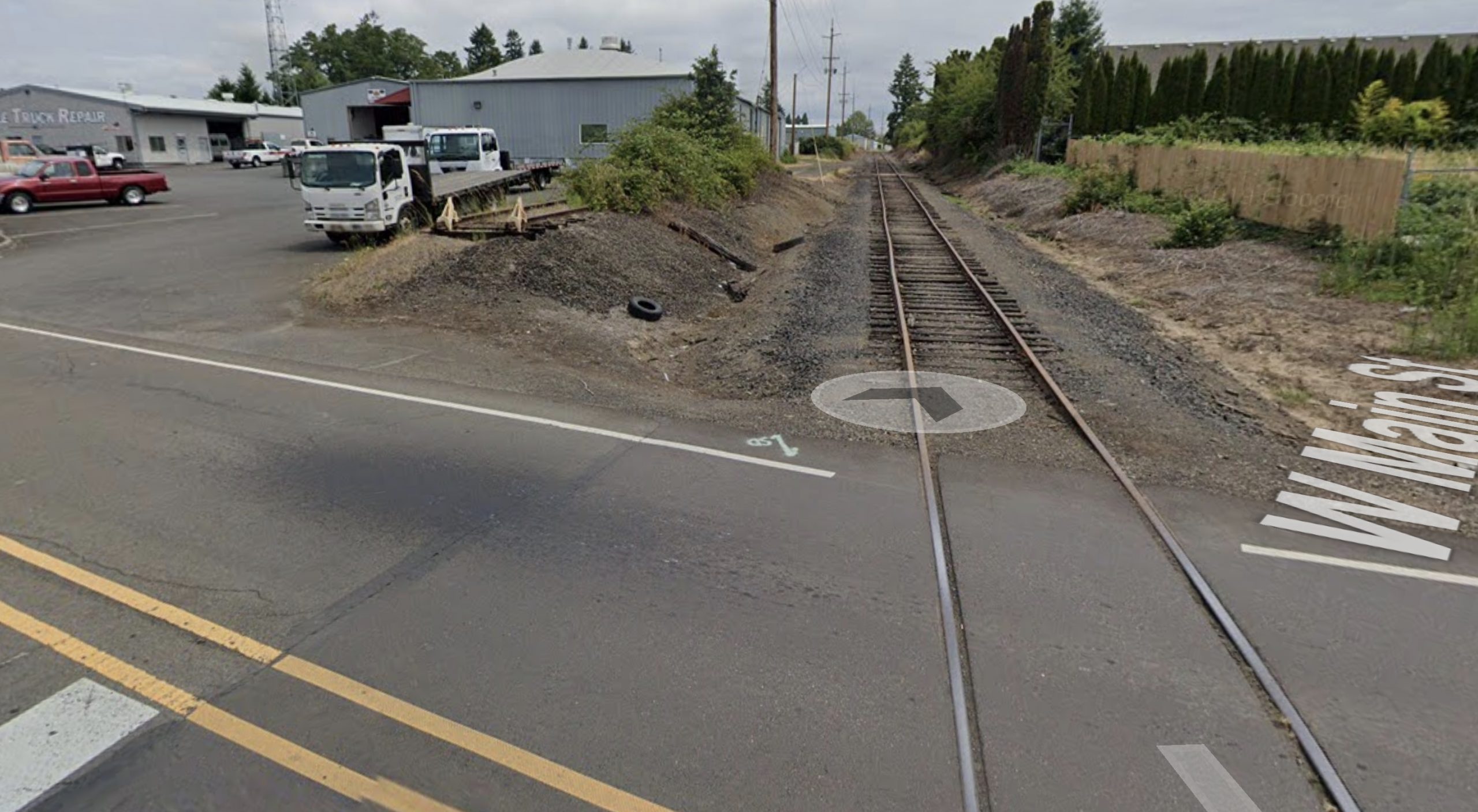
The Council Creek Regional Trail (that’s the official name, but I really don’t like the term “trail”) will provide a safe, east-west alternative to Tualatin Valley Highway (Highway 8), one of the most dangerous and stressful places for vulnerable road users in the region. The idea is to create a six-mile long carfree path just north of the highway that would connect Forest Grove (near Pacific University) with the MAX station in downtown Hillsboro.
The idea was hatched in the 1990s, the concept was adopted by Metro in 2002 and a master plan was completed in 2015. In 2019, Portland & Western Railroad issued a notice of intent to abandon its perpetual easement of the defunct rail line, opening up the possible to re-imagine the right-of-way. That same year, Washington County won a $1.6 million Metro grant for preliminary design work on the project. The first segment will be planned by the County in collaboration with the City of Forest Grove.
“The vision to connect the end of the TriMet MAX line in Hillsboro to the Banks-Vernonia State Trail and communities in Cornelius and Forest Grove has been a part of city and regional plans for many years,” states Metro’s project website.
Advertisement

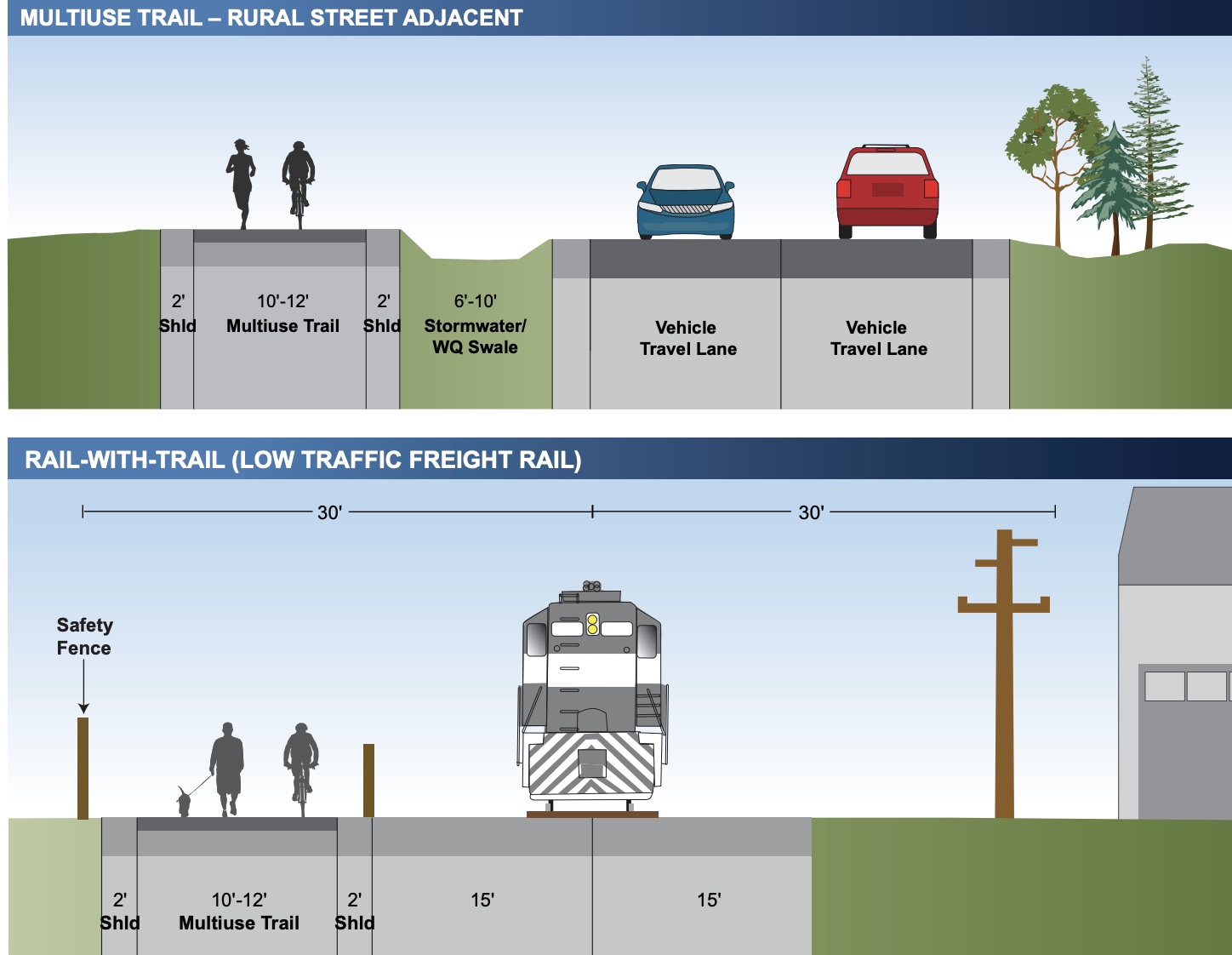
A regional Council Creek Corridor Working Group that includes Metro, the Oregon Department of Transportation, TriMet, Washington County and the cities of Hillsboro, Cornelius and Forest Grove was established in 2020, “to help shepherd the shared community vision.” That vision will include not only a new path but also, “a possible extension of light rail or other form of innovative high capacity transit from Hillsboro to downtown Forest Grove,” according to a working group document.
Potential benefits of the project that excite members of the working group include:
• Freedom to travel car-free, reducing climate impact and lowering transportation costs especially for lower-income households.
• An alternative to TV Highway that accommodates people of all ages and abilities — whether for fun and fitness or for getting to work, running errands, or catching a bus or MAX.
• Economic prosperity and vibrant neighborhoods along the Corridor.
• Opportunity to pilot new and innovative design and technologies for public transport.
One local rider who commutes to work by bike along this corridor on Hwy 8 said he’s “longing for this connection.” “Having a multi-use path from Forest Grove to Hatfield MAX station in Hillsboro could turn my bike commute into a year-round thing. There is no way in hell I am riding Hwy 8 in the dark/wet months of the year.”
An engineer with Forest Grove recently shared that the hope is to get the new path built within the next 5 years.
While the narrative and foundation of this project is solid, planners will be very cognizant of the debacle around the Yamhelas Westsider Trail, a project in adjacent Yamhill County that suffered a massive setback last month after stiff opposition from farmers led a majority of county commissioners to walk away from it.
Hopefully that outcome will be avoided here. Stay tuned for opportunities to get involved in the planning process and advocate for this project.
— Jonathan Maus: (503) 706-8804, @jonathan_maus on Twitter and jonathan@bikeportland.org
— Get our headlines delivered to your inbox.
— Support this independent community media outlet with a one-time contribution or monthly subscription.


Thanks for reading.
BikePortland has served this community with independent community journalism since 2005. We rely on subscriptions from readers like you to survive. Your financial support is vital in keeping this valuable resource alive and well.
Please subscribe today to strengthen and expand our work.
“Trail” is the term used to get money from the state and feds. After that, you can call it whatever you like.
Yeah and IMO if we stopped using that word we’d get a heck of a lot more money! I mean really, who thinks it’s a good political strategy to say “We need money for a bike trail!” versus, “We need money for a new active mobility corridor!” I don’t want to belabor this, just another word thing I think about a lot and my gut tells me “trail” just isn’t the best word here. Another big thing about it for me is that “trail” is more akin to dirt, MTB trails where we’re talking about a fully paved path for everyone. OK I’ll stop.
Or “non-motorized commuter corridor” rather.
i don’t like that either. Lots of path users are motorized these days… including e-bike riders and mobility device users. And I don’t like “commuter” because I think it’s a terrible habit/strategy to perpetuate the false commuter/recreation dichotomy.
The point is that the money for this project comes from a specific pot of money that can be used for “trails” along non-roadway pieces of right-of-way, but not for anything else. If it wasn’t a “trail”, then the money couldn’t be used and the project would continue to be delayed for another 50 years.
I prefer the term “footpath” myself, more British. “Track” comes to mind too.
I understand that David. Thanks. My point is that making change requires people to push past “Well that’s what we have to do to get the money”. Since that’s the case, then let’s change the grant/funding parameters!
A “trail” implies to me a narrow pathway that cars are not allowed to use. On the other hand, “new active mobility corridor” indicates to me a network of pathways along a mile-wide swath of streets and blocks that may or may not feature cars, with funding coming from a combination of roadway sources and with different highway agencies involved, including ODOT, Metro, various cities and counties, and lots of contractors and planners.
I agree, the language around funding parameters is archaic and to progressives, very messy and even broken. But it’s nearly always the more conservative parts of our society who get elected as our decision-makers or appointed as the chief bureaucrats, so the funding language has to be equally conservative to keep such people from misallocating the funds for nefarious purposes.
Great points David. Thanks.
@David, just to push back on your assertion about the funding source and its limitations. The funding from Metro was from the Regional Flexible Funds. Those dollars originate from FHWA and can be used on virtually any surface transportation project (freeways, transit, etc.) It was a regional choice to prioritize this funding to help build “trails” (or whatever name you want to call this project) over expanding roads, recognizing the important connections that grade-separated facilities provide.
Actually, you’ve more or less proved my point, for which I thank you. Had the funds been received directly by the community from the feds, there’s a good chance they would have been spent on roadway projects; but thanks to Metro reallocating the funds, they now must be spent on “trails.”
Thanks for that clarification, Jonathan. Yesterday when I referenced your The Marine Drive Path is 75% complete article in a photo, I changed my original wording from trail to path.
I agree, call it whatever you like. But the term “trail” isn’t going away anytime soon. It has always been and will continue to be the default term across the country for this type of facility. Not that it’s the only term. Greenway, regional trail, multi-use path/trail, shared use-path/trail, off-street path/trail, bike path — these terms are all used interchangeably. Just like road, street, highway and arterial are different words that can refer to different things, but are nonetheless often used interchangeably. At the end of the day, who really cares?
I’d say it is only a hand full of planners who really care about the terminology. It looks like we are into a minor semantics game.
“Arterial” generally refers to the streets and roads that carry the higher volumes of traffic and have greater connectivity. It’s part of a federal system of functional classification. The feds have stipulations for principal arterials and minor arterials. And the term “public road” is defined in the code of federal regulations and in the US Code. I’d make the citations if I could get on my broken hard drive.
I don’t know if any of the terms for a bike trail are defined in statute.
I do agree that very few people care much about the terminology.
30 years later, we’re drawing up plans?!? The pace of change is just simply aggravating. It is not surprising, just frustrating.
Excited to ride this thing if it makes it into the real world.
I share your frustration but there was still daily train traffic in the corridor until three years ago, and the railroad still controls the corridor. We’re doing everything we can.
We appreciate the work. The trestle work would be the key elements for people who are willing to ride gravel.
This was initially proposed as a MAX Blue Line extension, way back in 2006. Hopefully it pushes through.
This is great to see! Currently the three cities on this stretch feel isolated from each other and this will really help to bring them together. I can see this getting TONS of use from Pacific University students in particular, who might want to live in a bigger city (Hillsboro) but need to attend classes in Forest Grove.
This is really exciting. Washington County really has the potential to create a world class rails to trails network from the Portland & Western right of way as portions of it are abandoned.
I wonder what the next segment will be. I thought for sure that they would abandon the Rex Hill segment between Sherwood and Newberg after the trestle fire a few years ago, but they went ahead and rebuilt it. It was especially surprising given that the paper mill in Newberg was closed around the same time.
I did notice that Portland & Western also changed the status of the line out near Astoria (between Astoria and the mill outside of Clatskanie. It hasn’t formally abandoned it in the same way as the one in this story, but it’s effectively been abandoned since 2003. https://www.dailyastorian.com/news/local/wauna-astoria-rail-line-goes-dormant/article_a00d8c62-4190-11ea-b19f-e3ff2ba6dc85.html It could make for a great trail along the lower Columbia.
The Lewis & Clark Explorer Train operated from about 2003 to 2005, but funding stopped. The Amtrak passenger train stopped in about 1997.
Agreed. This route from Astoria to Clatskanie has the potential to be one of the most amazing trails in the country. Imagine riding along the Columbia for 20+ miles just like the Astoria Riverwalk. What is the state of the rails at Rex Hill?
I’m not sure about the state of the rails. I don’t know enough about railroad operation, to say definitively. Based on a quick check on google maps, and to my untrained eye it looks like it’s old track, with old wooden train ties.
There’s a Pamplin Media story talking about the trestle rebuilding. In it, they mention that it isn’t regularly used.
I found an ODOT report on rails in Oregon, and it sounds like the majority of the Portland & Western tracks haven’t been upgraded much since they took over running them in the 80s and 90s, and they may have been in rough shape then.
Some other interesting notes from the report. The right of way out to Astoria is actually owned by ODOT, but is leased to the railroad. There are two other segments of rail in the Willamette Valley that are at risk of being abandoned. The line from Silverton south to Stayton hasn’t been used since 2012 due to rain storm damage. Also, the short line to Dallas might be abandoned due to lack of customers.
Wow. Jesus imagine if we had a DOT, legislature and Governor who prioritized Rails to trails. Small towns all over OR would be rakin it in. I’ve worked with folks on the East coast who have fought tooth and nail for decades to get trails built. Whenever it happens it’s sort of a gold rush. It’s possible, but it really helps to have Governors like Baker in MA and Cuomo in NY (erm… other issues notwithstanding).
Politics aside weather and harsh conditions seem to be some of our best friends when it comes to acquiring ROW. The Salmonberry is a prime example. Please link to the ODOT report. A very small percentage of the ROW of the Astoria RR is “ridable,” I have found. Also, take a look at the Molalla Forest Road, which would connect Canby to Molalla. Jonathan did a story on it.
Sorry, I meant to link that in my comment.
Large PDF warning. https://www.oregon.gov/odot/Planning/Documents/Oregon%20State%20Rail%20Plan%202020.pdf
“It could make for a great trail along the lower Columbia”
I think you’re underselling it by quite a bit…it would be phenomenal. The rail hugs the shore for most of the way, with exceptional views of the lower Columbia River estuary. Cyclists would be in heaven for the scenery and relatively few road crossings; Birders would likely lose their minds.
I rode out to Astoria and took the excursion train back to Portland one of the summers they were running it (they carried bikes) and was absolutely stunned by the scenery between Astoria and Wauna. If you look at the satellite view in Googs you can follow the rail alignment for the most part and get a faint hint of how fantastic it could be.
I welcome the correction! I’ve never really explored the area east of Astoria. My only experience is driving to Portland on hwy 30.
I used to go to a friends houseboat there. I’ve also ridden it…. er tried! It’s one of my favorite places in OR. Wait what is this excursion train nonsense? How have I not heard of this. Do you mean a decade ago? I think the biggest issue would be the slough bridges which are likely rusted in the open position and… politics. Please correct if I’m mistaken.
Dang, this is pretty exciting – as a Beaverton resident, it’ll be great to have a car-free trail/path/whatever-you-want-to-call-it nearby.
Wasn’t that right-of-way designated as a future high-capacity transit corridor in Metro’s 2018 Regional Transit Strategy? I thought Forest Grove was looking at it for a MAX extension for years now.
The story notes that:
One of the graphics in the story shows what a MAX + path combo would look like.
Rad!
oh man, I hope this happens. The rail with trail option is the only option they should be considering. Long overdue.
Ha. This is absolutely disgusting. Nearly 2 million dollars to cater to less than, what, 7% of the population of that area? That money needs to go to further the ease of travel or expansion on TV. People drive, it’s a fact. Nothing is going to change that and we need to learn to accept single vehicle transit.
This isn’t about failing to “accept single vehicle transit” [sic]. This is not a binary choice between one or the other; it’s carving out a tiny little space for people who don’t choose to exercise the very expensive privilege of driving. Two million dollars is NOTHING – even on a per-user basis – compared to what we spend on single vehicle infrastructure.
This sucks! Traffic currently continues to be a problem on TV hwy with max rail being available. Waist of tax $$$.
You know what’s a big fat, forever-expanding bloated waist? The staggering amount of money spent on car infrastructure, which is actually a lot more expensive per user than bike and pedestrian infrastructure. And no, your gas-tax dollars aren’t paying for most of it.
I am all for a walking/bike path being put in where the tracks currently are but not a Tri-met rail. Also what are the plans for keeping this from becoming a homeless street/travel highway? There is already a major problem along Hillsboro Tri-met and by the cemetery being overrun with homeless and drug users. Brings quite a bit of danger to those nearby when the police aren’t allowed to deal with the problem at hand.
It’s a joke, Slow motion at its best!in the ’90s I was so excited about this,at that time I lived in Forest Grove by Pacific University,so for much more tax payers money is put into this turtle’s eternal motion plan. I think the group of people needs a doer not a sayer,make it happen! No more miking the cow!
A county planner mentioned this to me four years ago while we, both bike commuters, rode the MAX out of Hatfield Station. This after we both rode from Forest Grove on a dark and rainy morning on Hwy 8. Riding it at 5 am isn’t bad, but every afternoon I risk my life to get home. Bring on the trail, but also figure out how not to make it a homeless camp. There’s already a major camp near where this route would leave Hillsboro, and I don’t doubt it would be swiftly ‘populated’ upon completion.
Great news! I ride Hwy 8 when I have to, but I’d rather not.