There’s been important progress on a project that will build a carfree path on a six-mile stretch of an abandoned railroad line between Hillsboro, Cornelius and Forest Grove. The Council Creek Regional Trail has been a dream for decades and planning began in earnest after Metro published a master plan in 2015. Now Washington County has opened an open house for the project and hopes to add public feedback to ongoing discussions about the project by local elected officials and agency staff via various advisory committees.
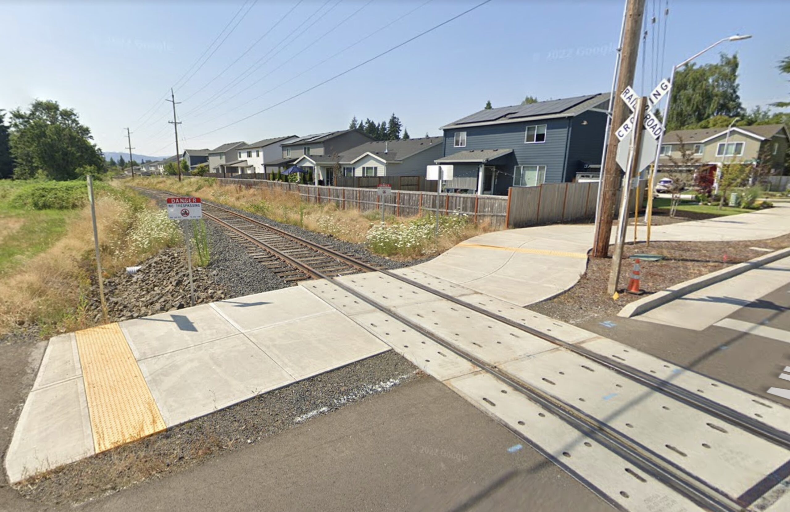
On March 20th, the project’s Elected Officials Steering Committee (EOSC) decided on an alignment for the project. They’ve chosen to run a public path ride along the center of the existing railroad right-of-way. The path itself will vary between 10 and 16-feet or so (depending on the segment) and it will feel very similar to other regional paths like the nearby Banks-Vernonia State Trail.

The alignment is just a quarter-mile north of Tualatin-Valley Highway, a major east-west arterial that has a terrible record of traffic deaths and injuries. While there are many efforts afoot to make TV Hwy safer and its transit offerings, TriMet also wants to make sure the rail corridor — and its full 60-feet of usable right-of-way — will also be available for them to extend the MAX from Hillsboro in the future.

At the January 23rd meeting of the EOSC, TriMet’s Director of Government Relations Tom Markgraf said, “I think you all know, TriMet’s interested. When a corridor becomes available, it’s really important to grab it quick and hold it for the future, and make sure that any improvements you make don’t jeopardize the ability to turn it into a transit corridor later on.” Metro Councilor Juan Carlos Gonzalez echoed that sentiment. “I think it is important for us to be able to act swiftly; to be able to preserve that future opportunity,” he said. “There’s strong alignment at Metro with this project.”
But any MAX extension is a long way off. The near-term plans are for a walking and rolling path that spur active travel and community development along the entire corridor (and also offer people an alternative to TV Hwy.) So far, $19 million has been committed to the project and the total price tag is estimated at around $28 million.
While the corridor is already designated as a high capacity transit route in Metro’s Regional Transportation Plan, there are already signs that some people who live along it will oppose any public access.
At that January meeting, Washington County Planner Julie Sosnovske revealed her team has heard that an attorney has already sent letters to people who live adjacent to the rail corridor, “Telling them that they may have reversionary rights and telling them that the right‐of‐way is theirs.” “We don’t believe that’s true; we believe that ODOT owns the right‐of‐way, but there are people receiving advice from an attorney and being signed on to a lawsuit,” Sosnovske continued.
It will be very interesting to see how this project evolves in the coming months and years. For now, you should consider spending a few minutes with the online open house and be sure to click to the last part where Washington County asks for your specific feedback about how you’d use the trail, what type of features you’d like to see, where trail access points should go, and so on. Comments will be accepted through May 14th.
If all goes according to plan, the project will finish design and engineering in 2024 and construction would begin in 2025. Washington County says they are shooting for an opening date in 2029.


Thanks for reading.
BikePortland has served this community with independent community journalism since 2005. We rely on subscriptions from readers like you to survive. Your financial support is vital in keeping this valuable resource alive and well.
Please subscribe today to strengthen and expand our work.
First order of business will be to get the Washington County Sheriff on board with patrolling that path and ensuring that it doesn’t become another linear homeless encampment. I would not be one bit surprised that the attorney signing up homeowners for the lawsuit is already telling folks that is such a camp is inevitable.
If there isn’t already homeless on that ROW, then I don’t see how paving it, removing vegitation, and adding lighting will be more inviting to camp on.
The existing carfree paths in Washington County such as the Westside Trail and Waterhouse Trail are already almost if not entirely free of campers. Washington County’s leadership is actually competent, unlike Multnomah County, so I don’t see this being likely to be a problem out there.
that’s because they are all camping on my neighbors (private) property… its a game, like chasing geese out of the fields. They leave (and leave their garbage behind) until you aren’t looking, then they return.
The revisionary land right claims stem from a disappointing supreme Court case a few years back.
I’m not knowledgeable about the issue, but it would be interesting to learn if there’s a difference in the rights of adjacent land owners depending on who sold the land and what the original easements were.
I know that many railroads were given land (that was totally, completely, 100% definitely unoccupied and not home to any existing people. [sarcasm for those who can’t tell]) by the federal government in exchange for building transcontinental railroads. I wonder if there’s a difference in revisionary property rights depending on who sold the land. For example, if the land belonged to the railroad and they sold property adjacent to the railroad, would that be different from situations where the railroad was built on an easement through land that had existing owners.
It depends. In most cases, if the railroad has not been formally abandoned (which I think this branch is just not used – a legal difference) then conversion to a rail trail is straightforward – even on easements. When a railroad to trail conversion takes places, the ROW is “railbanked” and the RR company (or sucessor) retains the right to re-activate the line.
I would guess that this particular stretch of rail is an easement. It was originally built by the Oregon Electric in 1908 (before it was acquired by the Spokane, Portland & Seattle/Northern Pacific). Considering that Hillsboro was a reasonably important farming center, I would expect the land in question already had farmers on it by 1908 (though that is speculative). Given that the Oregon Electric was never a land-grant railroad and the history of the direct region, it’s fair to assume it exists on an easement.
I looked at Washington County’s property information map application, and the right of way is depicted as being platted. The few parcels I checked were indicated as being owned by the state. (This was indicated by exemption status rather than ownership, which is withheld for reasons they explain behind a broken link.)
Which leads me to an aside: why is Oregon so stingy with public information? Before looking at Washington County’s app, Lane County’s property information map app was the worst I’ve ever seen. East of the Rockies, most local governments seem to use 3rd party vendors for their mapping apps, because it is the same data everywhere after all. But Lane and Washington both appear to have internally or at least bespoke developed their apps, and they both suck and make it hard or impossible to find parcel ownership info. Oregon sucks at providing public information in other domains, too, as you know if you’ve ever had the misfortune of needing to read a state regulation. More relevant to this website, I suppose, Oregon also sucks at building bike infrastructure. Maybe Oregon just sucks at government? /rant
Easements probably wouldn’t show up on a property ownership map, since they give the property owner rights over everything not related to the specific thing in the easement. For a railroad, this probably means that they (the property owner) retain the ownership, and have some limited rights to cross/inspect. I’m not overly familiar with property law though.
I agree that public access in Oregon is a nightmare, and that the government is annoying to deal with
To clarify, the right-of-way in question appears on Washington County’s property info map as a set of parcels that seem to be state-owned. So they don’t appear to be easements. Based on my very limited understanding of the railroad ROW reversion ruling, that makes it ineligible for reversion.
I am thrilled with the development of this path! It will run in what was my backyard growing up (that house was demolished for the Hwy 47 Bypass). As a kid I would have loved nothing more than being able to get to the McDonalds and back without dealing with TV Hwy.
damn 5 years to build a 6 mile path with only 10-15 minor crossings.
Still this will be awesome for those in the area!
Very excited about this! Just a little surprised at how long it’s going to take. Is it the actual building or the paperwork that’s supposed to drag it out?
Why not build it out similar to how the springwater developed? Upend the ties first on most/the entire ROW and prioritize the trestles to make it ridable for mtn bikes. 6 years is unnecessary.
Parasites.
100 years ago this section of railway was the Oregon Electric interurban passenger line from Portland to Forest Grove. The competing Southern Pacific “Red Electric” line ran on the tracks just to the south of TV Highway through here. It ran from Portland through Forest Grove and then south through Gaston, Yamhill and Carlton before rejoining the main line at St. Joseph, just north of McMinnville.
Path sounds great. However, everyone who lives there should reject any attempt to bring the Max to Forest Grove. Forest Grove does not need, nor are they prepared to deal with the additional homeless people, drugs, and drug related crimes the Max will bring. There is bus service to Forest Grove, that’s enough.
MAX to Forest Grove would make the city much better connected to the big employers in Washington County that are further from TV Highway (where the bus runs). The issues of additional homeless people, drugs, and drug related crimes almost certainly will not materialize. Forest Grove has fairly limited social services as is, why would a homeless person leave downtown Portland where they can get food, a bit of shelter, be mostly left alone, etc.?
Saying “There is bus service to Forest Grove, that’s enough” is just completely contrary to the experience that transit riders have. The 57 is a good bus, but it also is underinvested in and quite slow (it’s about 15 minutes faster from Hillsboro to Beaverton by MAX vs. bus). Look – I live near a MAX stop (17th and Rhine) and I have never had a single issue with what you are talking about nearby it. I have other issues with the “Orange” line (it’s way too slow! often slower than the bus!) but killing a big regional mobility project because of fear of homeless people would be a huge loss to Forest Grove, Cornelius, and the region as a whole.
I survived bike commuting on TV highway between Gaston and Hillsboro for 7 years. That stretch near the Winco in West Hillsboro has been a THRIVING homeless encampment on and off for years. Concerns are actually very well-founded, in my opinion.
That said, I FULLY support this trail. Can’t wait.
I am soooo excited about this project! It feels so silly that we can’t bike to the next town over because I think TV Highway is terrifying. It’s humbling though, to see the timeline. This would be a project for my baby. Too late for my older kids. I wish we could speed it up, but I’ll be thrilled when it happens. I hope neighbors see what a benefit this project will be. (I live along an active rail line, and I would be delighted if it ever became a bike path, though I might be even more excited if it stays a railway and re-adds passenger rail….I always wish we could easily ride a train to the coast in the summer!)