

Hopefully the experience of riding among treetops on the Red Electric Trail bridge away from the noise and stress of Beaverton Hillsdale Highway will be enough to take the sting out of years of delays.

(Source: BikePortland)
Work began on the Red Electric Trail project with a planning study in 2003 that was adopted by Portland City Council four years later. Since then there’s been some progress, but major pieces remain. The Portland Bureau of Transportation says a key, 600-foot section over a ravine at the west end of the Hillsdale Town Center will break ground early this summer. The ultimate aim is to create a low-stress biking and walking route on a 16-mile historic railroad right-of-way between the Fanno Creek Trail in Beaverton and the Willamette River near downtown Portland.
Advertisement
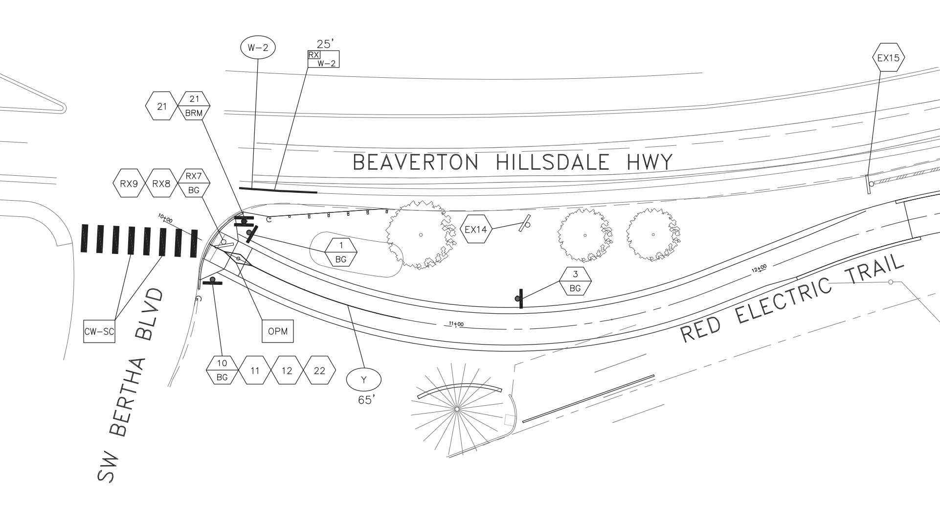
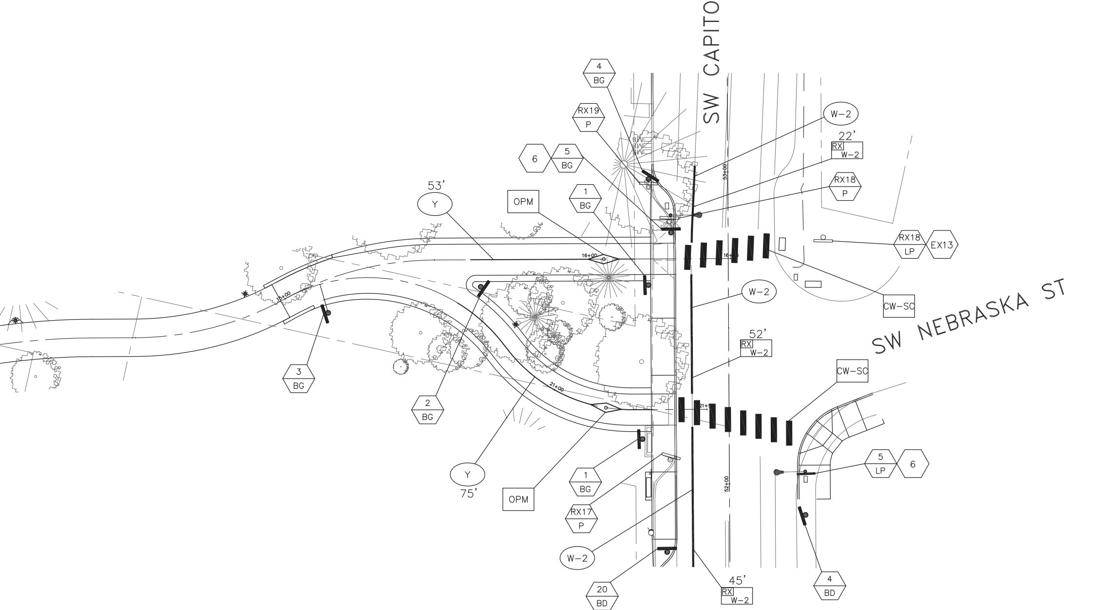

According to PBOT, the Hillsdale bridge segment will be 10-feet wide and will go from the intersection of SW Bertha and Beaverton-Hillsdale Highway (BHH), south over the ravine and then connect to SW Capitol Highway at Nebraska (across from Sasquatch Brewing). The $4.9 million project will also include new crosswalks and curb ramps at each end. City Council is expected to approve the construction contract at a meeting in early February.
The new bridge will give bicycle riders an option to avoid the high-stress location where drivers on BHH merge across the bike lane at Bertha. Drivers are supposed to yield to bicycle riders and PBOT has striped the section with green coloring, but most people disregard this and put bicycle riders in danger. BikePortland reader Shawne Martinez posted a video of this exact location on Twitter a view days ago.
(Video by Shawne Martinez/@RescueEwe on Twitter)Veteran advocate with SW Trails Don Baack, who has pushed for the Red Electric for over 20 years, shared with us via email that, “PBOT has postponed this project for a decade. Every time the next version had a smaller scope, until we now have a bare bridge with a north end connection that does not fit the expected bike or pedestrian traffic.”
On the good side, Baack added that this bridge, “Will make it possible to safely walk to Hillsdale from the west and north.” “Currently nobody walks and few ride east on the south side of Beaverton Hillsdale Highway because it is a suicide mission to cross 30-59 mph traffic turning onto Bertha toward Fred Meyer and the freeway on ramp. With the bridge, bikes and pedestrians will be able to get to the Hillsdale commercial area and Capitol Hwy in a safe manner.”
We’ll share more from Baack and about the Red Electric Trail in a future post. For now, check out PBOT’s project website and stay tuned for updates.
— Jonathan Maus: (503) 706-8804, @jonathan_maus on Twitter and jonathan@bikeportland.org
— Get our headlines delivered to your inbox.
— Support this independent community media outlet with a one-time contribution or monthly subscription.


Thanks for reading.
BikePortland has served this community with independent community journalism since 2005. We rely on subscriptions from readers like you to survive. Your financial support is vital in keeping this valuable resource alive and well.
Please subscribe today to strengthen and expand our work.
Awesome! Now we finally get to have a little taste of Belgium.
That’s a great example! I love projects like that, this bridge, and the N. Going St. walkway from last week that provide special experiences only available to people walking, rolling or biking.
I used to live on BHH near this area, and I didn’t own a bike then because I had nowhere I could really ride to. I suppose you could ride in the relatively wide bike lane even if it was unprotected and adjacent to 40 mph traffic (I used to do runs in the bike lane because there was no sidewalk and there were hardly any bikes for understandable reasons), but then you have sections like in the video that made traveling to anywhere outside of the area a completely scary prospect. It’s kind of ironic that I was looking forward to this bridge being built and then ended up moving to another section of town before construction could even start. This bridge is not enough on its own to get people who live in the area to ride bikes more, but it’s a start and I’m looking forward to seeing the end result.
Agree. We lived on BHH our first year in Portland, and between the lack of sidewalks, hilly topography and busy roads, it was a rough place to bike/walk/run. We ended up moving to outer SE and it was SOOOOO different (even if there are dirt roads and incomplete sidewalks there too!).
Agree, but also it’s nice that some of these most dangerous intersections are being addressed. The issue has always been that it’s all piecemeal making realistic route-planning a roll of the dice depending on your home address and end destination. Many people will still avoid rides if the ride out of their neighborhood goes through dangerous areas with 30-35 mph traffic with no shoulders. Maybe in a few more decades… good incentive to stay in shape 🙂
Is there a map (somewhere) of the full 16-mile route? Curious to see the path of the “near Willamette” and Fanno Creek Trail.
Not the full ROW but here’s a link to the segment in Portland.
you can see a map here https://swtrails.org/trails/red-electric/
Thanks eawriste and Jonathan, much appreciated!
Great for Electric Bikes!
They are mopeds.
Great place for tarps and tents!
Now we tear up our rails get rid of our cars so we can be locked in Paradise Portlandia forever and ever amen.
You guys should really hang out more. You seem to get along.
And live on the income from selling “friendship bracelets” and subsiding on a diet of grass juice and yams while living in a yurt. Everyone’s idea of paradise /s
Wut?
This site shows an abused child, head down in face diaper next to some BS pol holding the item of submission in its PAWS.
PORTLAND = PATHETIC
Genius! This is like going back to advanced lit class.
Glad to hear this is finally moving forward. Don’s right about the delay. However, this will only be meaningful if the city and Metro get serious about acquiring necessary easements/ROW to make this route complete to Oleson Rd. If so, it would be an absolutely lovely E-W walk/bike route at railroad grade. A big plus in hilly SW.
How about a functional, physically protected cyclepath along Capitol Hwy in Hillsdale and the South side of BHH instead of a “path” or signed sharrowed route on residential streets?
Oh goody Spring water corridor II, just give it a couple months and the tents and drug addicts will move in. It truly sounds amazing and fun, but our society is a lil broken. If you live anywhere near this, do yourself a favor and move now! Otherwise, please watch out for your dogs and anything not bolted down. Not to mention random people bathing in your pools/ponds. A real treat indeed! Just hop on Nextdoor for any neighborhood adjacent to the corridor, and you’ll see I’m not close to exaggerating.
Antifa. You left out also blaming Antifa.
Hey Stikybun! C’mon out to SW and ride our streets and you’ll see that homeless encampments are already here. In fact, I rode yesterday on Bertha under the Capitol Hwy viaduct – right where the Red Electric Bridge will be – and there are large homeless encampments on either side, populated by fit-looking young people, from what I could see.
Encampments are happening on any publicly-owned land where the people aren’t chased away, so it’s not a function of the MUP. I would think that an MUP with a nice bridge would actually discourage camping by making the camping more visible.
In F estates by Lambs in the wooded entry way by 2004. Permanent camp for that year. A block from the country club even. THAT WAS 2004. Might be time to wake up, but you refuse.
What?!
I know I’m supposed to be grateful for any dedicated bike/ped infrastructure that the taxpayers are willing to spend $$ on, but am I correct in thinking that this bridge will basically move people from one busy street (Capitol Hwy) to another busy street (BHH)? That is, the bridge won’t help cyclists *avoid* these high-traffic streets but will actually deliver us more efficiently *to* these streets, where we will then have to wait for traffic to stop so we can *cross* the busy streets to get where we’re going.
Is it too much to hope that ped-cycling infrastructure might one day actually help cyclists get around more quickly and efficiently? Or must we always be dumped on some busy road where we have to wait and then we piss off the motorists who have to wait for us to go from stopped to 8 mph, with all of the associated intervals of waiting to make sure they are stopped so we can go, and we are stopped so they can go, rinse and repeat.
Basically these kinds of projects are designed to give bikes and walkers a dedicated space *away* from cars and trucks so the cars and trucks can go faster. But the efficiency and speed of the bikes are not prioritized – in fact, we might even be slowed down. But oh – the view!
Sorry if I don’t sound appropriately grateful but projects like this one won’t move us closer to a cycling network that puts us on par with the car-truck network. So people will continue to use the car-truck network b/c it’s faster and more efficient.
Fred, you’ve just described the last few decades of Portland’s streets. Instead of building safe multimodal designs, PBoT has built high profile, high price connectors to essentially nowhere. I love this bridge. It’s a great design. But how do I or my family and friends get to it safely? For the same price ($5 Mil) as the bridge, PBoT could have built protected bike lanes on Capitol Hwy through Hillsdale and a physically separated cycletrack for much of BHH. But we need the bridge for this reason: parking and car capacity.
This future Red Electric Trail will be parallel to BHH but on a neighborhood greenway with streets that are a dead-end to cars.
Were laughing at this psyop at lunch here in Reno. Duh. . . .why dont people have faces in the drawings then ?
Poor Portlandia, gone forever.
I love Racter the AI poet!
Not being familiar with this project, I thought it was a pilot for crossing the Willamette in NoPo to drop people on Saltzmann. I got realllly excited at first!