If you care about making streets in southwest Portland better for biking and walking, the Portland Bureau of Transportation has just done you a huge favor.
Yesterday the bureau released the draft version of the Southwest in Motion (SWIM) plan. It’s an impressive, detailed, and easy-to-use blueprint for activism that should lead to projects on the ground in very short order (and help tee up larger projects in the future).
Modeled after similar planning documents for east and northwest Portland, the SWIM plan offers a prioritized list of projects, possible design treatments, and even identifies potential funding sources to actually get things built.
Below is a before-after of what we’ve got in southwest for biking and walking now and what PBOT has called for in this plan:
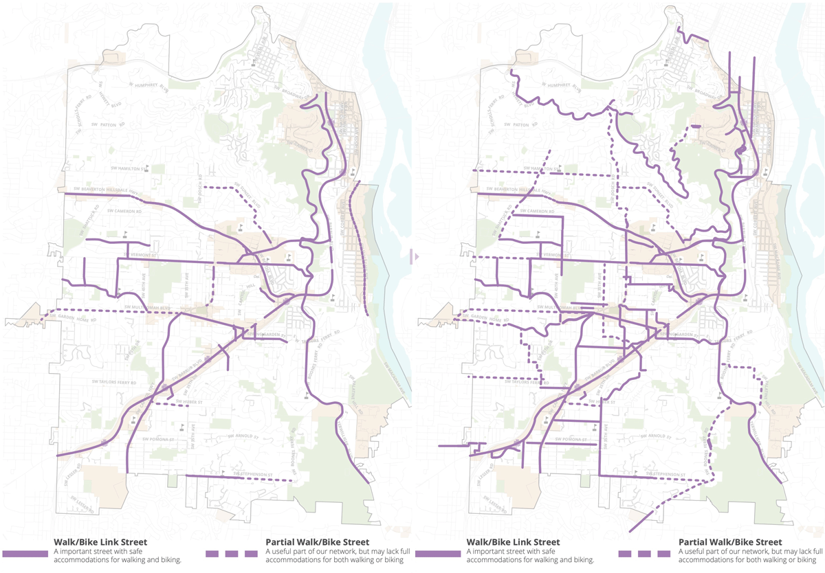
It doesn’t get as much attention as east Portland for how much it lags behind the central city in active transportation infrastructure, but if you’ve spent any time in southwest (like we did during our SW Portland Week coverage in 2015), its challenges and deficiencies for biking and walking are abundantly clear. A lack of continuous streets, hilly topography, and narrow roadways make mobility very daunting for anyone who’s not using a car.
According to U.S. Census data, 65% of southwest Portland residents drive alone to work. That’s 7 points higher than the citywide average. Another big difference from east Portland? Census tracts within the project area are also richer (median household income is $89,578 versus $61,118 citywide) and whiter (percent person of color is 15% versus 26.9% citywide).
With that bit of context, here’s why I’m excited about this plan…
Is it any good? And the “Falbo Factor”
“SWIM is a big step in the right direction.”
— Eric Wilhelm, Hillsdale resident
The PBOT project lead is one of their brightest new planners, Nick Falbo. Prior to being hired by PBOT, Falbo gained notoriety for creating protected intersections for bicycle users. While employed by Alta Planning + Design, Falbo created a nifty web tool that allowed us to experiment with Portland’s cycling mode share goal in an interesting new way.
While he’s still learning to balance the politics and public pressures that accompany groundbreaking new designs, this plan is a showcase of Falbo’s talents. I’ve seen a lot of PBOT plans over the years — and I often think they should do more building and less planning in general — but this SWIM draft is really great.
If you’re an independent activist, a neighborhood advocate, or a non-profit staffer, you now have an invaluable tool to push for changes. PBOT themselves makes this clear in the plan when they say, “Continued community advocacy for projects will be instrumental to the success of this plan… The project descriptions are designed to provide the critical information necessary for neighborhood advocacy of local priority projects. Effective advocacy with the bureau and with local elected officials will provide continued urgency to address the real infrastructure deficiencies of Southwest Portland.”
Eric Wilhelm is an active cycling activist, Hillsdale resident, and member of the Stakeholder Working Group. He wanted PBOT to go even further with road diets and transit priority lanes; but acknowledged in an email this morning that, Wilhelm feels that in addition to a focus on short-term implementation, the best part of the plan is how it tackles current gaps in the network. “We have so many places where the bike lane just ends on a street with fast and heavy traffic or there is no sidewalk to get to a transit stop,” he added.
What’s in it?
The meat of the plan is a list of high-priority, short-term walking and biking projects. PBOT has separated them into “Top Tier” and “Second Tier”. The former are add-ons to existing routes and closing gaps, the latter are larger-scale projects that would expand the network and/or build connections to other major investments (like future SW Corridor light rail or Red Electric Trail).
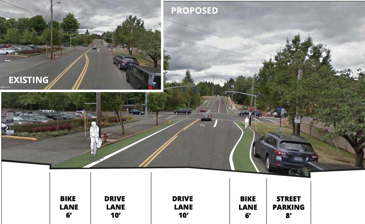
PBOT has also highlighted key projects and innovative new design treatments (see below). These new designs are key because they remove excuses for PBOT to do nothing in the face of narrow streets or other challenging existing conditions.
The plan also outlines other city programs (like block parties, community plazas, and urban trails) that we can use as leverage to make changes happen.
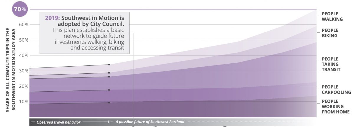
My favorite part of the plan is when it looks into the future. PBOT points out that since 2010, almost all of the new work trips have been absorbed by modes other than driving. “Driving in Southwest has plateaued,” they write, “and the other travel options have picked up the slack.” There’s also a nifty chart that envisions that trend continuing into the future (below). The chart includes predictions that will impact transportation. In 2021, PBOT says, “Major innovations in electric micro-mobility technologies allows for wide-spread adoption. These new e-bikes allow a greater share of Southwest Portlanders to overcome barriers to cycling such as hilly terrain and longer distances.”
Design treatments
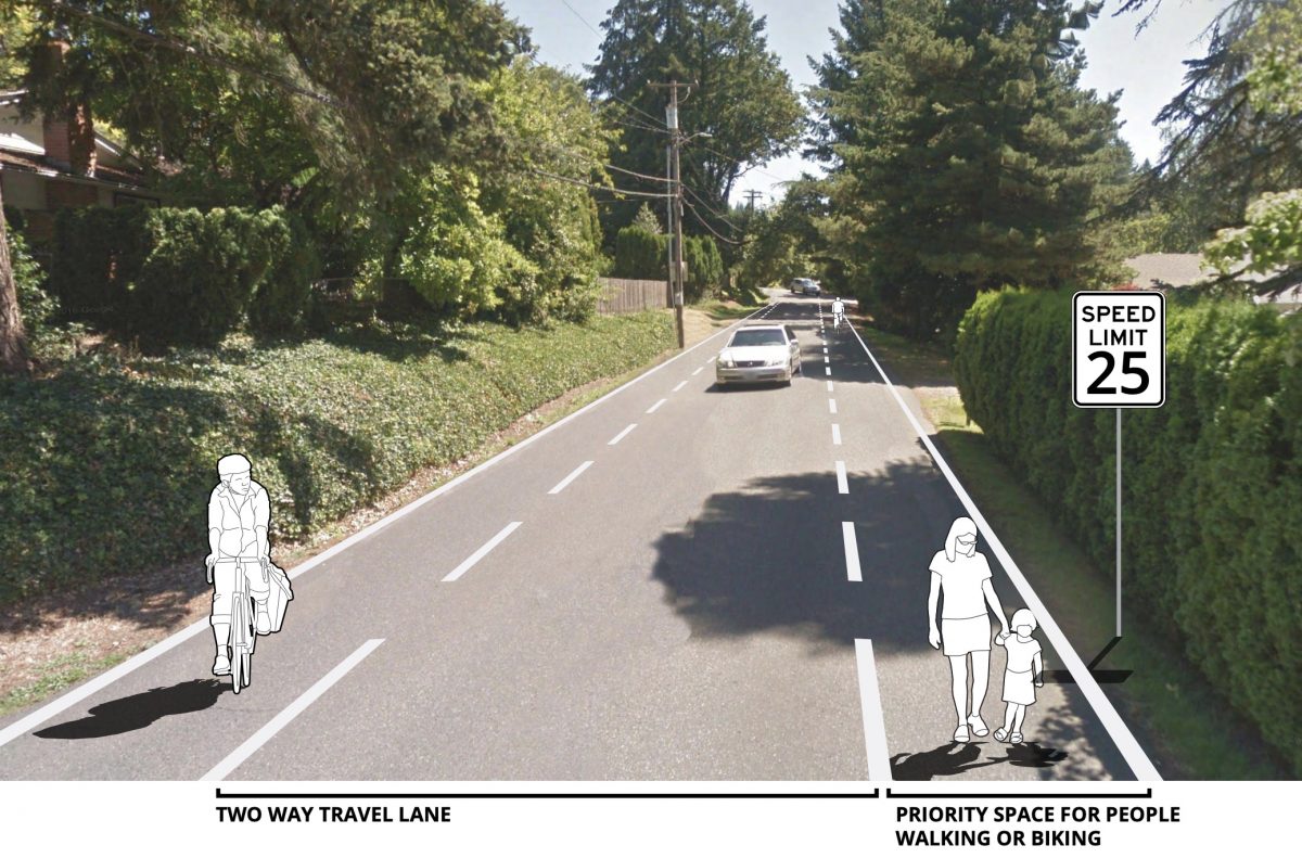
PBOT has put some cool new treatments on the table in this plan.
Advisory shoulders (a.k.a. advisory bike lanes) have been talked about for years, but the city has yet to pull the trigger on them. These are used on slower, low-volume roads that are are “too narrow” for bike lanes. The idea is to create suggested shoulders that car drivers are allowed to venture into if necessary; but otherwise provide some safety and space for walkers and bikers. PBOT wants to find a good pilot street to test them prior to rolling them out citywide. A potential location for these is SW Fairmount or SW Hewett.
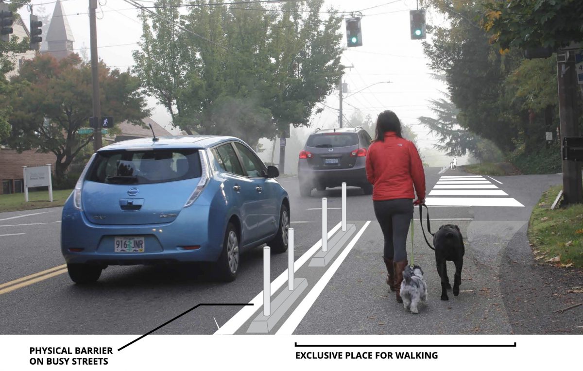
“Safer Shoulder” (below) is another new treatment in the plan. PBOT says they’d, “provide a separated place to walk on a roadway, out of the path of moving traffic.”
Notable projects
(Photo: Jonathan Maus/BikePortland)
This plan doesn’t just have aspirational project lists. There are several things that could be built quickly.
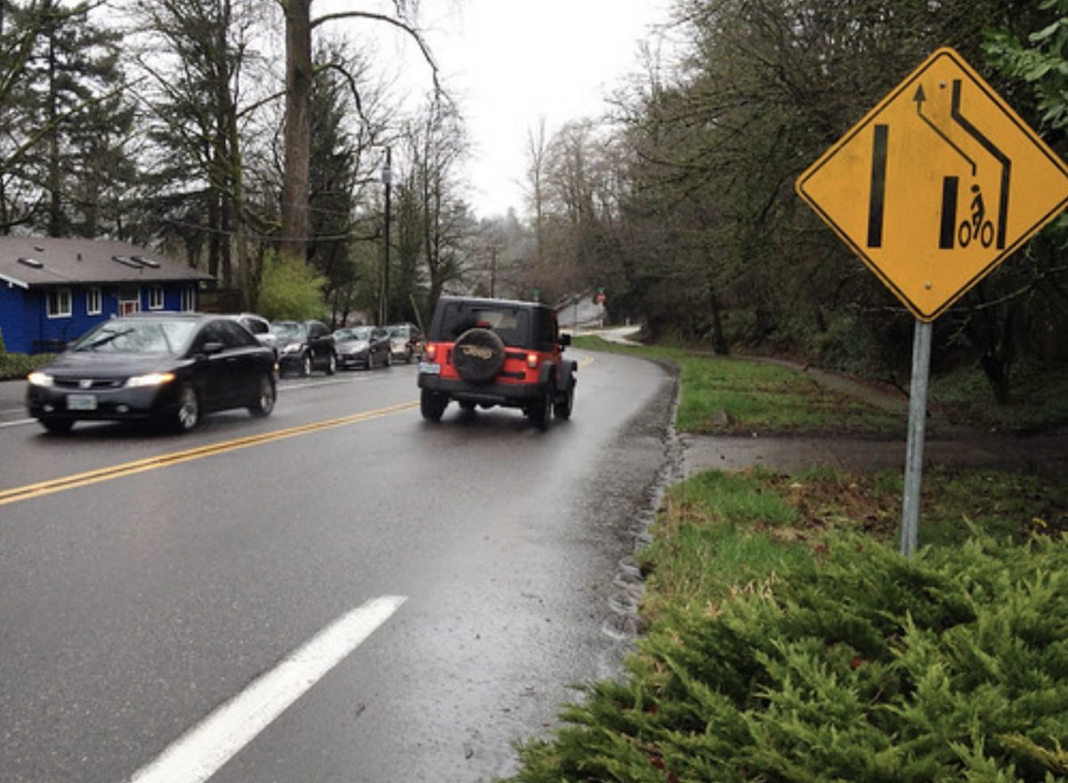
PBOT says they have funding allocated for protected bike lanes on SW 35th and SW 45th avenues. On 35th, they will remove a parking lane and center turn lane to make room for protected bike lanes that connect Jackson Middle School to SW Huber Street. On SW 45th, PBOT wants to remove a parking lane and stripe bike lanes from SW Pendleton to Nevada to connect the Hayhurst neighborhood to Gabriel Park.
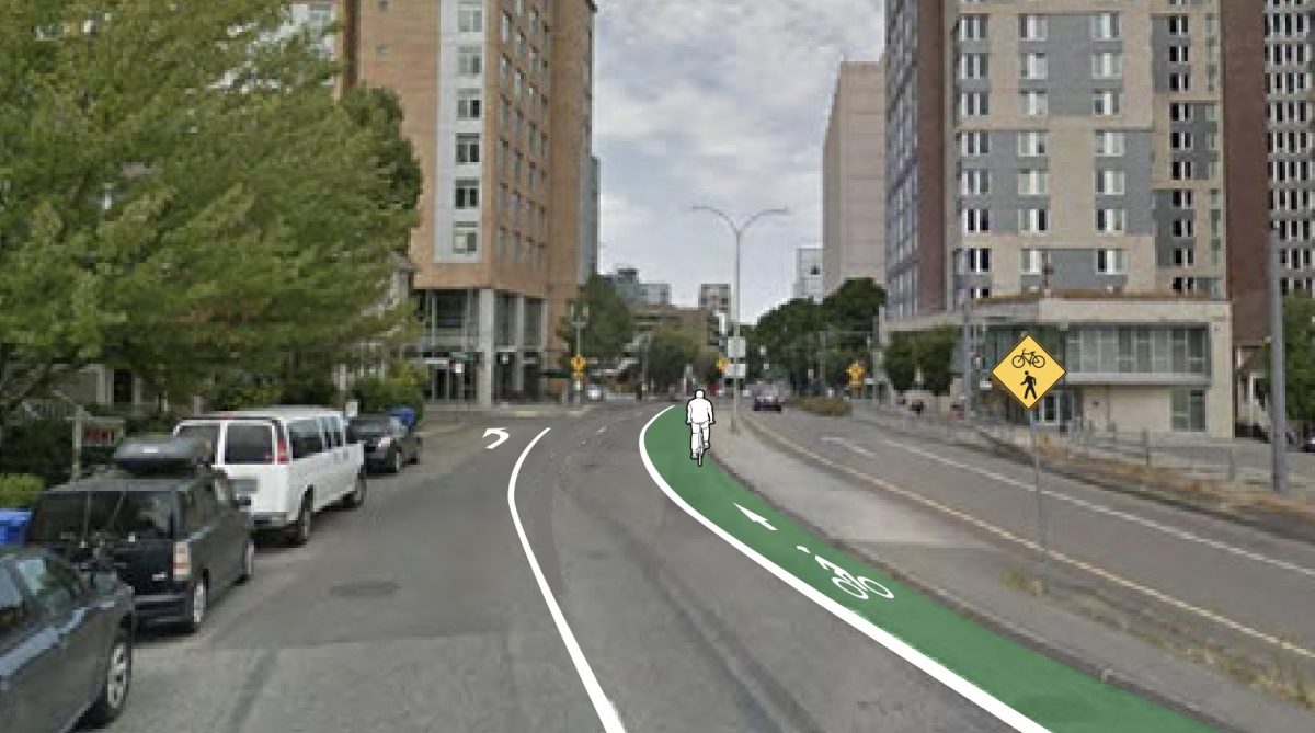
Another project identified in this plan is a long-awaited fix for SW 6th Avenue as it crosses I-405 and enters the central city (below). PBOT says it’d cost just $15,000 re-stripe the existing lane as it approaches SW College Street to provide a more continuous bikeway and eventually tie it into a Central City in Motion project slated for SW Jackson.
How about a neighborhood greenway on SW Montgomery from downtown to Fairmount? That’s project RP-26. It would add greenway treatments on Montgomery from SW Vista to Talbot to help make a safer connection between downtown and the popular Fairmount/Council Crest Park look.
During our “Gap Week” coverage in 2016 we singled out the dropped bike lane on SW Terwilliger near 7th. I was pleasantly surprised to see this address as project BP-20. Surely we can find $150,000 to do this!
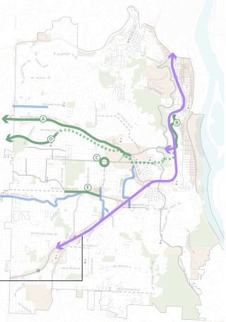
While actionable projects are great, we also need big visions. At one of their open house events, PBOT shared a poster titled, “Major Projects for Future Study”. Among the exciting projects on the list was the “Southwest Cycle Superhighway” which would be a low-stress bikeway to be built as part of the SW Corridor light rail project (below).
How we gonna’ pay for all this?!
PBOT says the prospects for future funding are “promising, but uncertain.” But unlike others plans, PBOT doesn’t leave southwest hanging with no dedicated funding. They list $935,000 in a mix of one-time ($185,00 for bicycle lanes, $550,000 for crossing enhancements via Fixing Our Streets program) and annual ($200,000 through their existing “quick build network completion” program) funding. Other potential sources of funds PBOT calls out in the plan include: Federal “flexible funds”, Metro’s 2020 transportation investment bond measure, Transportation System Development Charges and a new Local Transportation Improvement Charge program.
Portlanders are tired of plans. We want to build things. Hopefully this plan helps us do that faster.
Let’s take PBOT’s hint and use it to our advantage. Here’s what you need to help:
– Official SWIM project page.
– Draft SWIM plan. (PDF)
– Draft project list. (PDF)
– Public feedback survey open until May 24th
– Stay tuned for City Council adoption date.
— Jonathan Maus: (503) 706-8804, @jonathan_maus on Twitter and jonathan@bikeportland.org
Never miss a story. Sign-up for the daily BP Headlines email.
BikePortland needs your support.


Thanks for reading.
BikePortland has served this community with independent community journalism since 2005. We rely on subscriptions from readers like you to survive. Your financial support is vital in keeping this valuable resource alive and well.
Please subscribe today to strengthen and expand our work.
This is great. Thanks for covering, JM, and for Falbo and his team for putting together.
A project we could do relatively quickly and with dedicated funding is SW Multnomah Blvd PBL from 69th to 45th. The Mult/Garden Home intersection is being revamped and a survey for it asked residents if they wanted a PBL. 67% said yes! But we need more support so PBOT goes back and asks for sufficient funding to do the striping/wands along with the intersection project. Timur Ender is managing that project.
Sw Multnomah Blvd is the flattest route into Portland from the SW (well maybe Barbur but I’m too afraid to go on that). It is also where the Fanno Creek Trail ends. This could be a great extension of the trail.
FCT to Multnomah. From 45th to 30th, Multnomah is only paint, but then it’s a small raised lip PBL for a few blocks after 30th. It will make connectivity to Terwilliger and downtown Portland that much better for SW PDX and Beaverton/Tigard residents.
I ride that stretch of Multnomah every day, and agree with most of the what you said. The Garden Home/Multnomah intersection is designed to right hook bikers as it currently stands. I voted against a protected bike lane on Multnomah because they have a hard enough time keeping the current, unprotected bike lane clear of debris.
I think the connection at the east end is worth discussion as well. Going west to Multnomah from Spring Garden I can cross Barbur at a light on 19th, but going east I use 22nd, and that requires crossing all of Barbur without a light. If I’m headed downtown, I continue on Multnomah to Terwilliger, but I can imagine riding next to a freeway onramp, and then having to mix with offramp traffic at Terwilliger would be terrifying to more timid cyclists.
Barbur goes through the highest point at the crossroads with I-5 and Capitol Hwy near Barbur Transit Center. Oleson and Multnomah are definitely flatter.
I am surprised the Humphrey westbound to Hewett eastbound routes were not mentioned. for riding too/from Scholls/26 to top of CC/Vista were not mentioned. This has been comfortable for me for the last 40 years.
I have been surprised at seeing 3-5 riders a day climbing Scholls Ferry to Canyon in the last few months. I have been going on Canyon lane from the vicinity of 77th to the east end of Raab Rd. since 1980. This was even before there was a walkway between the 2. Straight up Raab (literally) to Scholls/Humphrey/Hewett.
When I was commuting from Washington Square to Clackamas for 13 years in the 80’s to 2001, I quickly refrained from trying to cross Barbur at the top of the hill where Multnomah goes to the entrance to I-5. I quickly began riding across the bridge and stayed to the right taking the Terwilliger exit. I rode down Taylors ferry to take the Sellwood bridge. Coming back I caught LaView to Corbett then Barbur after crossing I-5. Straight down Multnomah/Garden Home. Easy riding with fog lines. Not for the feint of heart.
I never did care for FCT. Too Dangerous with Joggers and earbuds.
Do you mean riding up SW Scholls Ferry Road to SW Canyon Court, Canyon Drive, or Canyon Road? Multnomah County is collecting thoughts from people about sidewalks, bike lanes, (or a stilted boardwalk) on Scholls for their Roads Capital Improvement Plan. Another online open house will take place in late May / early June.
I dig the Hewett improvements. It already operates like a shared street in many ways, like a junior version of Fairmount. Additional signage, striping removal, and calming would make it even better. Both Hewett and Humphrey are partly under the jurisdiction of Multnomah County.
https://multco.us/file/31070/download
Great job PBOT, can’t wait to do a deep dive on all these projects.
The timing is appropriate, too. E-bike sales to SW Portland commuters will be greater than sales of traditional bikes over the next few years if they aren’t already, specifically so they can conquer the hills and take advantage of these improvements.
Humphrey Blvd is considered by SWIM stakeholders and the City of Portland to be unsuitable for bikes and pedestrians. The Western section is under control of the Multnomah County transportation department. The property owners don’t pay City of Portland property tax. But perhaps someday they will privately fund needed improvements. It is within their means.
At the Patton-Talbot-Dosch beginning of Humphrey, St Thomas More School believes that creating sidewalks and bike lanes that parents could pull off in motor vehicles to drop off children for school is a safety hazard.
Even at car 20mph, usually exceeded, Humphrey sight lines make it dangerous for bikes to take the lane. Many bold do, of course. But in >20 years driving it, and bicycling it, the bicycling numbers are decreasing. I would never bicycle it today.
The dream would be very expensive uphill side retaining walls along Humphrey Blvd to widen the usable right of way and create a two way shared bike and pedestrian route protected by a curb.
In the immediate term, Bike Portlanders will be key in designing Hewett, both directions for bikes and pedestrians.
Thanks Bike Portland for publicizing the project. Everyone is welcome to submit public comments to PBOT. Commenting on Bike Portland without that is sideline discussion.
Humphrey has banked turns like a race track. A good traffic calming would be to repave the street one fine day and remove the banked aspect of the turns. That Catholic school should help pay for improvements to biking and walking.
Hewett Blvd only needs the banked curves removed and the occasional blackberry removed, but it is one of the last bike / walk streets that needs help. So many others need help.
Lot of great stuff here! Though I can’t help but laugh/cry that my house is smack dab in that big empty rectangle at the bottom right of the “after” map.
John, that is Macadam where it has been a PBOT target to eliminate since the 70’s. PBOT keeps trying to stuff a dangerous MUP in it’s place but the right of way keeps having buildings and fences built where the bikes go. The MUP is too dangerous for bikes because of peds with earbuds walking side by side, and gateposts in the middle.
There’s a MUP on macadam itself? Or do you mean the trail along the waterfront?
Macadam would enable a lot of people to bike from LO to Portland pretty easily. Seems like a bad idea to completely take it out of consideration.
The trail along the willamette is quite bumpy, narrow in many parts, and has lots of pedestrians (and apparently floods occasionally). It would be nice to get arterial car-quality infrastructure for bikes too… a pipe dream but I’m curious why it was completely eliminated from consideration.
Does PBOT not want any improvements to Macadam ?
You have an odd definition of dangerous. I grew up near that greenway, learned to bike on it, and still ride it all of the time. It is a great option for those cyclists who are not willing to mix it up with the actually dangerous traffic on Macadam.
Nick and team, this looks awesome. Please fix the “Advisory shoulders/bike lanes” picture so the added sign says 20 MPH not 25. That’s clearly a residence district, and clearly a local street or collector (not an arterial which would be the only exemption from the 20 MPH law and Ordinance).
The picture is quick, speed limit on that street (Hamilton) is 25 mph.
I have a question that may relate to all the “In Motion” plans. Is it kosher to spend “In Motion” dollars on moving more motor vehicles faster, or are those really supposed to be for ped/bike? What about transit? I ask because I’m on the NW In Motion committee. Some NWIM dollars are proposed to be spent on (stunningly expensive) traffic signal upgrades. At least a few dollars apparently went to a study on “upgrading” the TSP traffic classifications for NW 18th/19th, NW Glisan/Everett, NW 25th Ave. etc. from local to collector. I’ve heard that a lot of the dollars (in NW) come from parking revenue. Some people seem to think that means the projects should be for cars, other people seem to think “In Motion” projects should be exclusively be for infrastructure so people don’t have to drive or are less likely to be hurt or deterred by people driving. Is there some guidance on this, or is the range of projects that should be in these plans open to interpretation?
Doesn’t making the car-focused roads better for drivers (easier to use) enable making the shared roads safer for non-drivers, and enable a little diversion now and then?
I ride that same stretch and also deal with the Barbur Blvd crossing. It’s really dangerous because not only do you have to cross Barbur, but the people turning left from 22nd apparently don’t think you have the right of way since you’re on a bike. It’s always dangerous. I was also almost killed turning left of Springarden when a car decided to do a diagonal skid right into the parking lot instead of turning right on 22nd towards Barbur. I hate that part of my ride.
I think I’ll just sit and cry. The first photo and drawing show an “improvement” that puts in a door-zone bike lane. (Legally parked motor vehicles’ doors can open out as far as 12′ from the curb. Add in a startle buffer and the width of a cyclist and you will be able to see that parking and bike lane extending only 14′ from curb completely fails.)
And please, please, please don’t sing any praises to advisory bike lanes. All these do it further encourage our motorists to pay no heed to any lines on the pavement, and we’ve already got enough trouble with that. Yes, all the cool kids are talking about these and have been for years, but the American context isn’t the proper place for them until we make some serious investments in our social infrastructure. I’d rather see generous use of “Bicycles May Use Full Lane” signs and 9′ lanes that allow for 15 mph speed limits.
Which SW street / road bike improvements do you want the most ?
I agree, Carfree. I live and bike in SW, and the photos don’t impress me. What’s so great about painting a bike lane next to a door zone, where there is open pavement now? That just pins the bikes against the car doors.
I know cyclists want to build political goodwill by praising plans like this – at least the city is doing *something*. But there is nothing groundbreaking about this plan. It is simply tweaking the car-centric status quo.
Tigard has some of those advisory bike/ped lanes, but they did a truly horrific job installing them. I don’t use them because the variable widths mean sometimes the lane is less wide than my body.
If you think I’m joking, take a walk or a ride along Tiedeman from Tigard Street to the just before the Fanno Creek bridge. There are several spots that are no wider than the length of my foot (that’s about 10 inches long, in my shoes).
Please, PBOT, do NOT use advisory lanes. Just bite the bullet and put in some bike lanes.
You’re confusing edge stripes with bike lands and advisory bike lanes.
https://goo.gl/maps/LzCawkATYei6D97J6
Advisory bike lanes are skip stripes. Edge lines, aka fog lines, are placed on the outside edge of a vehicle travel lane to define the road edge and can vary from six inches to a couple feet.
bike lanes have the bike symbol in them:
https://goo.gl/maps/m2X5Qqzk2Tef9Sfo9
The examples prove why people confuse bike lane markings with edge lines. You say “bike lanes have the bike symbol in them”, and yes, they should, but they are often sparse–only one every several hundred yards even–as your example shows if you proceed down the street in that view.
I believe (not sure) that bike lanes have a 6″ wide stripe, and edge lines are 4″, but that’s not particularly evident to people if you don’t see them side by side for comparison. Plus, when 4″ wide lines are repainted, the new paint often isn’t aligned exactly with the old, making them wider than 4″ and adding to the confusion.
I’m glad you and several others noticed Macadam has gone from partially good to totally gone. The Willamette Greenway Trail is fine for what it is, but people should be able to walk and bike on Macadam itself. They should also be able to cross it to get from the neighborhood to the river trail. As it is, there are stretches several blocks long with no marked crossings, including some where the median forces people walking to scramble through the planting to cross.
The “Advisory shoulders/bike lanes” picture is correct. That picture is of SW Hamilton just west of Shattuck and the speed limit on Hamilton is 25 mph. The new 20 mph speed limit is for Neighborhood streets and isn’t the rule of thumb for collectors or arterials.
David, I disagree. “Neighborhood streets” (or, as some people have described them elsewhere “residential streets”) is not a legal description. Where applicable, 20 MPH is a speed designated by a law passed in Salem and implemented (in full) by Council by Ordinance, not a rule of thumb. SW Hamilton west of Shattuck is a collector, as opposed to a local street or an arterial:
https://www.oregon.gov/ODOT/Data/Documents/City_Portland.pdf
(see legend in lower left).
Based on what I can see on google maps, it is pretty clearly in a residence district (and I presume a school zone past Bridlemile Elementary) as defined here:
https://www.oregonlaws.org/ors/801.430
The Ordinance
https://efiles.portlandoregon.gov/Record/11631411/
applies to “non-arterial streets under the jurisdiction of the City of Portland in a
residence district.” It should be 20. I’m happy to connect offline if you have other thoughts or questions. -Scott.
ICYMI… SWIM passed yesterday on a 3-0 vote by Commissioners Eudaly, Fritz & Mayor Wheeler. There was no public spoken opposition.
Disappointed that the Red Electric trail isn’t on here. Very disappointing