(Images: PBOT)
Last night at the Bicycle Advisory Committee meeting, the Portland Bureau of Transportation shared an update on their SW Main paving project.
As we shared back in December, the section of Main between 1st and 3rd (just west of the Hawthorne Bridge) is getting a much-needed renovation. The project will come with new pavement and updated striping that will improve access for bicycle users. We got our first look at the plans at the meeting last night from PBOT Project Manager Norberto Adre (norberto.adre@portlandoregon.gov).
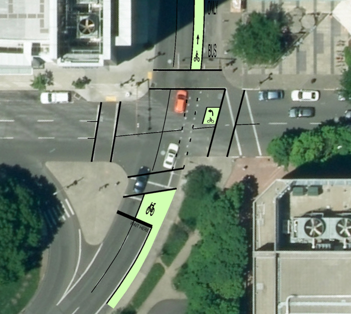
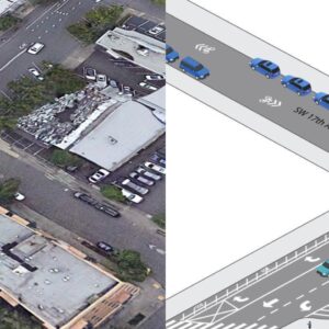
The striping plan calls for a new, unprotected green bike lane and bike box on Main as it approaches the intersection with 1st. There will also be a left-turn box installed at the northwest corner of that intersection to help bicycle users who want to go left (south) on 1st. The unprotected green bike lane will continue westbound between 1st and 2nd. Mid-way through the block the green will be striped to give motor vehicle users and TriMet bus operators a place to merge into the right-turn-only lane. Between 2nd and 3rd the unprotected bike lane returns to the curb and loses the green color. There will be a new, green left-turn box at 3rd and Main. West of 3rd the bike lane goes away and PBOT will install sharrows.
Advertisement
Here’s the image PBOT shared last night:
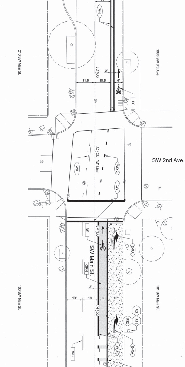
UPDATE, 9:00 am: I asked the project manager for the lane widths and he sent me the plan drawing (below): The green bike lane between 1st and 2nd will be six-feet wide and sandwiched between two 10-foot lanes to the left and the 10-foot right-turn only lane on the right. The curbside bike lane between 2nd and 3rd will be six-feet wide with a two-foot painted buffer next to lanes that are 10.5 and 11.5 feet wide.
Construction on the project is expected to start any day now and will last for about five weeks. PBOT’s plan is to do the work at night (between 7:00 pm and 6:00 am) to avoid traffic impacts. During that time they will close the block between 1st and 2nd to all users (sidewalks will remain open). During the day, only one lane of SW Main will remain open. It will be shared by all users. Because this section of Main gets so much traffic, PBOT has rerouted buses away from the block and is strongly encouraging bicycle users to avoid it.
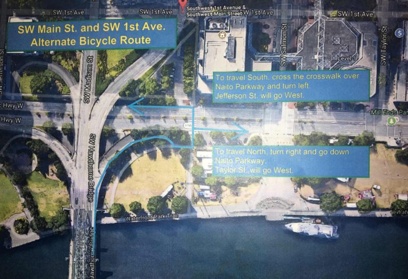
At the meeting last night the project manager handed out the map below with suggested alternate bicycle routes. The idea is to use Naito via the Hawthorne Bridge off-ramp and then enter downtown via either Jefferson or Taylor.
This project has an estimated cost of $500,000 (much of the cost is due to a concrete (not pavement) pad that will be installed for the TriMet bus stop between 1st and 2nd) and is being paid for through the Fixing Our Streets program.
— Jonathan Maus: (503) 706-8804, @jonathan_maus on Twitter and jonathan@bikeportland.org
Never miss a story. Sign-up for the daily BP Headlines email.
BikePortland needs your support.




Thanks for reading.
BikePortland has served this community with independent community journalism since 2005. We rely on subscriptions from readers like you to survive. Your financial support is vital in keeping this valuable resource alive and well.
Please subscribe today to strengthen and expand our work.
This is an incredible let down. The new design does very little to address the problem of buses weaving across the bike lane. It does nothing to provide physical protection of cyclists on one of Portland’s busiest bike routes. It does very little to prioritize transit over single occupancy vehicles.
Given the fact that the turning lane / bus stop is being poured in concrete, this configuration will probably be with us for a generation.
Initially I was somewhat incredulous that you were criticizing such an obvious improvement over the current situation. But now I realize how conditioned I am to accepting (and even being happy with) marginal improvements when I should raise my expectations.
Jimmy, your reaction and realization might also explain why no one at the Bike advisory Committee meeting said anything about the design either (including myself!)
I chatted with one of the PBOT managers about this earlier this summer (the day PBOT was handing out donuts on better Naito). We discussed the possibility of a transit-only lane, disallowing right turns onto 1st, and a bus-protected cycle lane. This configuration would solve the bus/bike leapfrogging and make the exit from the bridge much safer. The PM was concerned that there is too much “demand” for cars to turn right onto 1st.
This is broken 1950s thinking. Demand fills the supply available, we should prioritize efficient roads, then make the streets safe, and only then see if we have room for any driver conveniences.
*right turns onto 2nd (not 1st as I wrote above)
Wait, really?? BikeLoudPDX seriously needs to have someone vocal at all of those meetings. Someone from BikeLoud, I think maybe Terry D-M (?) applied for the BAC and was turned down, I wonder why….
There are a number of problems with how this is going down:
1) PBOT Active Transportation didn’t have the clout/bandwidth/ambition/connections to change Maintenance’s default and turn this into an opportunity for major improvements
2) PBOT Maintenance doesn’t have a diktat from on high (Leah Treat should issue this) that whenever they do paving projects on major bikeways, a potential redesign process needs to be kicked off
3) The BAC didn’t kick and scream about this missed opportunity at this extremely-high traffic, high-stress location.
These problems could be fixed by some not-too-painful changes by leadership, with big dividends in the quantity of low-hanging fruit that is harvested annually. Maybe this is an opportunity for some motivated folks from BikeLoudPDX to have a meeting with Dan Saltzman and Leah Treat.
multiple bikeloudpdx people applied.
I think if this were just a re-striping at a low cost my feelings would be a lot less strong. But for half a million dollars I’m in disbelief that this is the best the city could come up with.
This is what platinum looks like!
Yes it is almost like performance art watching the bikes, cars and buses interact at that intersection. Some bikes hold the left lane, others who are turning right on 2nd will jump in the right turn lane, while others will hold the bike lane then turn right into the left lane on second (of course this causes a huge conflict with the buses who are going straight and crossing the bike lane). And it is not clear whether this move is legal for cyclists or not (turning from the second lane into the left lane is usually acceptable and doesn’t cause a conflict, but with the buses here there is always a conflict against the bike lane, and it’s not clear at all what the cars are expecting people to do). At the current moment it’s just fortunate that there are a lot of cyclists during peak hours so drivers are aware that we’re out there, and that traffic speeds are quite slow.
This “redesign” does nothing to solve any of this. 🙁
I take the bike lane and right into the left lane of 2nd… I’m usually turning into the left-side parking area though, not the actual lane, which helps to avoid any cars that might also be turning… this is because I’m about to dismount and walk west up Salmon…
I don’t think it’s legal to turn from the bike lane since there’s a turn only lane… but I’m trying to avoid horrible pavement that could flat my tires by staying out of the turn lane…
once they repave I’ll be taking the new bike lane to 3rd and dismounting to walk north…
I just get on the sidewalk on the west side of Main at 1st to get into the garage of the 1st and Main building on 2nd, rather than try to fight over to the left lane. Just not worth the risk.
This is at best a half-assed solution that continues to send the message that the city is deprioritizing mass transit and inconsistently communicating the presence of cyclists with these confusing interrupted sections of bike lanes and green paint. That said, after years of bouncing along and having more than one light fly off my bike in this cratered stretch between 1st and 2nd, I am relieved to hear that the road is finally being repaved. It’s pretty pathetic it has taken this long to get the pavement repaired, but I’ll be glad when it’s done.
Sounds moderately helpful, but unfortunate that they couldn’t also have done something about that ridiculous deer statue clogging up the road and causing confusion.
That’s an elk, not a deer 🙂
That ghastly, emaciated elk statue (looking the wrong direction) is a Portland treasure, thankyouverymuch.
It’s gazing longingly toward the West Hills, or at least that’s the official position.
I hate art.
“Clogged” or slowing it down a bit?
The Elk was there first….. seriously, the roadway grew around it.
Should have been taken care of years ago, there really is no excuse for leaving this piece of road in the poor condition it’s been in for years.
I for one am glad there are no physical barriers proposed as I prefer to use the left lane because I am often turning left within several blocks of the bridge exit.
Total garbage. Physical protection is the only improvement that will significantly increase safety and mode share.
Yeah, as someone who’s not comfortable riding with traffic, I would never bike on this. I’ll stick to the sidewalk.
I think of getting a summons for riding 5 mph on the sidewalk when the street design is too dangerous as just another inevitable bike tax.
you’re risking a ticket…
I believe that riding a bike on the sidewalk downtown continues to be illegal. I keep asking the wrong people why they don’t bother to put up signs if they really want us to keep off.
I’m happy about the paint and improved road conditions. This section of my morning commute is one of the least pleasant, and for motorists to know where they should be in relation to me is a positive.
UPDATE, 9:00 am: I asked the project manager for the lane widths and he sent me the plan drawing (below): The green bike lane between 1st and 2nd will be six-feet wide and sandwiched between two 10-foot lanes to the left and the 10-foot right-turn only lane on the right. The curbside bike lane between 2nd and 3rd will be six-feet wide with a two-foot painted buffer next to lanes that are 10.5 and 11.5 feet wide.
I have the unfortunate pleasure of riding this stretch of pavement every day and this project as proposed is great from a pavement quality perspective but otherwise is disappointing.
Just a general question, how is someone on bike supposed to get to the transit mall or Broadway? Those are the two most direct ways to get through downtown to Barbur or Terwilliger which are the only two ways to get to SW. Given that, as a cyclist, I have to take the lane to get to either of these roads this new configuration is worse asthere is less opportunity to merge in with traffic (cars/trucks/buses) and as other people have noted the left lane is generally preferable for this stretch due to the connections.
How is the road design going to allow cyclists to merge when the bike lane abruptly ends? Unless there’s an unannounced bike box on 3rd before the sharrows are placed on the roadway this is going to create conflict in a spot where previously it was pretty minor.
Those two-step left turn bike boxes look like they’re in a scary position. I’d be afraid of people making right turns (illegally) and not being mindful of where the bikers are. The one for SW Main also looks problematic as I can envision a bus trying to take the shortest path between the lanes and clipping the bike box that looks to be in the middle of the intersection.
Wouldn’t it be safer to place the bike boxes prior to the repainted pedestrian crossing? That introduces a conflict between pedestrians and left-turning bikes, but bikes should be at a low enough speed to where this shouldn’t be an issue.
I doubt this will to anything to deter people in cars from merging into right turn lane without signaling on top of a bunch of cyclists. Right turns should be prohibited onto SW 2nd here—between the bus stop and bike traffic, it just isn’t safe. Anyone traveling north can wait to turn at 4th.
That would have allowed for a much better design. The bus stop between 1st and 2nd would be moved to an island, and bike traffic would be protected for that block. It would also save the busses some time, as they wouldn’t have to weave across the bike lane and back.
What we in the bike community are facing now is like the movie ” The Empire Strikes Back.” In the earlier years the empire of motorized single occupancy transportation was complacent in their dominance of transportation infrastructure. Hard work by Portland Bike advocacy groups got us some significant gains and good infrastructure. But now the empire of darkness is feeling the challenge to its rule by the rebels and is fighting back, often behind the scenes. Each gain in human and earth friendly infrastructure will be harder, take more fighting, and in many cases like this change to Main Street be less than we hoped. But eventually the death star ,that is happy motoring,will crumble under its own weight and the rebels will triumph.
I’m concerned with whether there will be any improvements to how cyclists are meant to merge into the lane of traffic when the bike lane ends. Currently it’s a bit of a free-for-all, with cyclists trying to gain advantage by riding to the right of stopped cars, but being forced to merge before the elk.
I’m also concerned with vehicles (especially buses) encroaching on the bike lane on the off-ramp from the Hawthorne just entering this area.
Not to mention the fact that northbound riders have six blocks of 5-car-wide street to navigate on 2nd before they get back into some bicycle specific infrastructure. Not that you’re out of the woods when you’re in that lane, either.
I’ve struggled with getting into commercial centers the entire time I’ve lived here. The bicycle lanes lead up to a downtown (pick one, Woodstock, Mississippi and Sellwood all share the same fate) and then you’re thrown to the wolves. With steel teeth. I hope someday we’ll stop throwing up our hands in the busier areas and actually make them inviting and safer.
I go through this challenging stretch of road on the way to work. The worst part is the messy merging that occurs. I’m glad we’ll get an extra stretch of bike lane (between 2nd and 3rd), but the only real solution is to do something about traffic backing up by the elk statue between 3rd and 4th. The right lane gets clogged (cars turning right onto 4th must wait for pedestrians in the crosswalk), and the left lane is clogged sometimes, too.
*
Thus, the new bike lane will dump us into a festival of backed up traffic. Options include:
– stay to the right of auto traffic waiting at 4th (prepare for right hooks!)
– stay to the left of auto traffic waiting at 4th (I hope you’re comfortable bunny-hopping the rocks paved into the roadway at the statue)
– stay behind the last auto in the line (did you bring your face mask?)
*
I usually just weave through it all, whichever way is most open. The auto pileup isn’t my fault or my problem, and weaving is better than sitting in the right lane sucking up auto exhaust, but it’s of dubious legality. It’s amazing to me that the premier bike bridge in this city of bikes and bridges dumps riders right out into this mess. If the current improvement is a part of a larger, incremental solution, then I applaud PBOT’s movement in the right direction. Seems like it’s just an opportunistic use of some repaving, though, without any consideration of where that bike lane will put riders when it runs out.
*
A real solution would be to create a bike lane going all the way up through the congestion (maybe as far as the Schnitz). If it’s to the right of the right car lane, it’ll be a dangerous place to ride, because cars will be clogging that right turn onto 4th. If it’s in the left side of the left car lane, it will require cyclists to merge far over from the right side, and there will also be the possibility of left-hooks at 3rd and 5th. I think a better place would be the inside: on the left side of the right car lane. That would require taking out some of the barriers by the elk statue. Better yet, turn the whole right or left lane into a bike lane! SW Main Street see way more bike traffic than SW Stark, yet it’s Stark that has the big buffered bike lane.
Try using the left vehicle lane to get around the elk, then back to the right lane once you’re past 4th.
Exactly, that’s exactly what I end up doing, much of the time. It’s what I meant by “weaving:” because of the tight traffic, I end up weaving through a bunch of slow or stopped cars to do it.
Jonathan or others —
Was there any mention of widening the chute where the bikes transition from the sidewalk of the bridge deck to the roadway? (About 200′ upstream from the 1st Ave traffic signal)
Here
https://goo.gl/maps/TzTRVFpB8FD2
This is too narrow for a cargo trailer, doesn’t meet any standards of guidelines for multiuse paths. And the car travel lanes are, I think, excessively wide here, so there’s plenty of space for an additional foot or two on the chute.
Looking at the Google Street View image I see it is on the bridge deck itself, so maybe its a Multnomah County issue, not PBOT.
Just curious,
Ted Buehler
The problem with the meeting last night was that the project manager came with the intention of only talking about the detour. It wasn’t presented as, “what do you think about this striping plan?”
That’s part of a larger problem: this design wasn’t published on PBOT’s website until yesterday, meaning there was no meaningful opportunity for comment. I can never understand which projects fall into the “3 years of public meetings” category, and which fall into the “no public involvement” category.
my hunch is that this project was always a paving project first and foremost… so it didn’t come from the same planning context as, say, a street/lane redesign project would come from.
Yep, you hit the nail on the head.
I’m absolutely sure you’re correct, but that’s not a great reason. With finite resources PBOT leadership should be making sure every dollar spent hits as many goals as possible.
(See also: repaving of SW Broadway last year.)
“3 years of public meetings”
that’s for inner portland — in outer east portland it’s 5+ years.
Projects like this reveal the extent to which Vision Zero is a joke.
Motorists will drive wherever the can drive. Stripes and paint are irrelevant. They might help a little bit but if a motorist can drive over it they will.
*they
they need to keep that bike lane going past the elk statue… turn the right lane into a buffered bike lane…
I really hate those “move off to the right and hang out here to take a left turn” painted islands. They’re a perfect representation of PBOT’s philosophy of pushing people on bikes off to the side and letting us fend for ourselves rather than create REAL infrastructure that works intuitively.
Couldn’t agree more. “Let’s take a one-step process for motorists and make it a two-step process for cyclists!” Ugh.
That section of road is ridiculous. Not sure if the pavement or the merging is worse. I turn right onto the sidewalk and go two blocks, turn left to rejoin 2nd Ave. I feel for everyone who has to head West up Main. That would be a frustrating barrier to commuting if I had to take that.
When I cross the Hawthorne into downtown I’m almost always going to turn left at 5th. From 1st I merge over to the left between 1st and 2nd and/or between 2nd and 3rd, to be in (and take) the left auto lane before the elk. This new configuration, if I’m reading it right, will prohibit lane auto lane changes between 1st and 2nd, so I will have only the block from 2nd to 3rd to change lanes to the left. I won’t be using any of the new striping.
You’re allowed to leave the bike lane to prepare to turn left. So, legally, at least, you should still have full freedom of movement.
Yes. One of my issues with the 2 step turn boxes is that they create the expectation that “this is what people on bikes should be doing” which has the potential to create conflict with drivers who think you’re doing it wrong.
And this is not paranoia. There was an article (can’t find it at the moment) that showed that many instances of driver on rider road rage are based on the driver not knowing that what the rider was doing was legal. I’ve encountered this myself.
Those turn boxes have many issues, and you identified an important one. Another is that most people don’t know how to use them. Another is that they leave you in a vulnerable-feeling position. Another is that it takes a lot of time to make a simple left turn. Another is…
That it is an improvement over the existing conditions is not sufficient anymore. Wayne Gretzky used to talk about not skating to where the puck is, but to where it’s going to be. Right now, PBOT is skating to where the puck was 20 years ago. Not acceptable.
Exactly. This project exemplifies complacency. People who care about safety should expect more.
But Vision Zero?!?!? LOL
Those floating left turn things are the height of ridiculousness! Also, at a minimum, they should paint both lanes with sharrows so people on bikes can turn right or left. This is a pretty big step backward for PBOT. They have very little cred in the active transportation areas right now and they need to be relying on consultants for projects like these.
It’s not much, but on the bright side at least now I actually know how I’m expected to navigate turning left off the Hawthorne Bridge. I’d never been able to figure out whether I was expected to merge all the way left (which is what I do if traffic’s clear), roll over to the sidewalk at the far corner and wait till Naito has green to proceed (which is what I do if there was too much traffic to merge left), or if it had just never been thought about at all and so it was just a “do your best; good luck” sort of situation.
In addition to the design comments provided so far…the question I have for PBoT design staff (and the PBAC) would be why does Portland continue to only use partial [street width] bike boxes versus the Dutch standard of bike boxes continuing across all lanes; thus facilitating cyclists merging over at a stop signal to make a left turn?
I don’t even understand what that left turn box at the end of the Hawthorne Bridge off-ramp means. Where am I going in that thing? Am I meant to be turning left onto 1st across two lanes of speeding auto traffic that is coming up behind me? Because that is crazy!
You are supposed to stop in that box, facing southbound, and proceed across the intersection when the light turns green for southbound traffic.
I’m not happy with the overall design. But that is how this box is supposed to work.
Wow! That is far from obvious.
I have pretty good photos of the elk, black & white and color, taken with my neat old Olympus OM4 and Gossen Luna Pro incident meter.
Since the elk has been well documented, I propose to replace it with a statue of Leah Treat on an “Orangie.”
Ditto the comments about the left-turn boxes. Does this design include a No-right-on-red sign? I’m pretty uncomfortable with anything that involves putting a foot down inside the crosswalks. Do the Dutch do that?
From what I’ve been reading and watching recently about the Dutch traffic design, bike boxes were nixed decades ago in all but the most extreme of circumstances – opting instead for the Dutch intersections and full separation (at roundabouts for instance). It seems like they tried bike boxes and realized that it wasn’t safe because they use the same space as vehicles, which they try to avoid. Same with two-step left-turn boxes.
Zero Vision.
What is that bike box at the end of the bridge ramp for? There is no danger of right hooks there.
Here is some context about the First and Main project. This project was developed as part of the Fixing our Streets program. The primary goal was to address the failing pavement. At the same time, by addressing the pavement condition, PBOT also had the opportunity to create more prominent bike striping. A more long-term improvement as BIKEPORTLAND readers and others in the community have suggested isn’t possible within the current reconstruction project. Such a thoroughgoing improvement would need an evaluation of a significant portion of the road system around the Hawthorne Bridge, that is, Madison, Main and 1st, 2nd, 3rd and 4th. While such an evaluation wasn’t possible within the budget and timeframe of the current pavement reconstruction project, it is possible under an initiative like the Central City Multimodal Project. In other words, this is not the end of the story when it comes to bikes, busses and the Hawthorne Bridge. Thanks to Fixing our Streets funding, we will get a much smoother ride off the bridge and more obvious striping. Then as we begin the public process for the Central City Multimodal Project later this year, we will have the opportunity to work with the community and take a more comprehensive look at this critical route.
Thanks for the info! I’m guessing that, since the bus stop will be (literally) set in concrete, moving it later will be more expensive, perhaps requiring more paving work.
I understand why this project may not be the vehicle for reworking the whole system around the bridgehead, but there are many small things you could do without that level of scrutiny. For example, did you consider adding wands or otherwise creating more space for cyclists on the offramp?
This project just feels so… status quo. We’ll never meet our goals without a little more forward motion.
This isn’t an entirely satisfying answer. The West Quadrant Plan, adopted by City Council in March 2015, shows SW Main as a major bike route coming off the Hawthorne Bridge. The first draft of amendments to the Transportation Systems Plan, proposed as part of Central City 2035, were published in February 2015. I think the candidate Fix our Streets projects were released about the same time. The voters approved Fix Our Streets in May 2016—almost a year and a half ago. The description for the project we voted to approve said that the “project will also address bicycle safety for bikes coming off the Hawthorne Bridge and merging with buses which stop between 1st and 2nd.” The project being built does the very least possible to meet that project goal.
I just hope that we’re not having this same discussion when SW 4th Avenue is repaved in two years.
I like the way they’re trying to get everything that’s a pain in the ass (which is buses, anything turning right) over to the right of us.
The Problem: It starts out on the left of us. So that means somewhere, a crossing has to happen. And, buses inevitably pull back out from the curb after stopping, so that makes two crossings (or at least, a crossing and a merging).
The Solution: A bikes-only signal at 1st, like at Broadway & Williams. Bikes are stopped while buses and right-turners cross over to the right. Then the light changes and those people are stopped while all the bikes cross over to the left.
Timing of the light changes should be such that the buses pulling back out after stopping will be doing so during a “red for bikes” phase, meaning there won’t be a bus/bike conflict there.
Done, and done. Concrete is a good idea for the bus stop, especially modern prestressed concretes. The asphalt under those buses looks like water splashing in slow motion after a while.