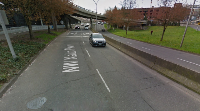
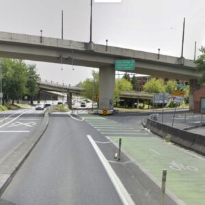
(Image: Google Street View)
After nine years of sometimes elaborate plans to connect NW Naito Parkway’s bike lanes north and south of the Steel Bridge, the city’s transportation bureau has found a way.
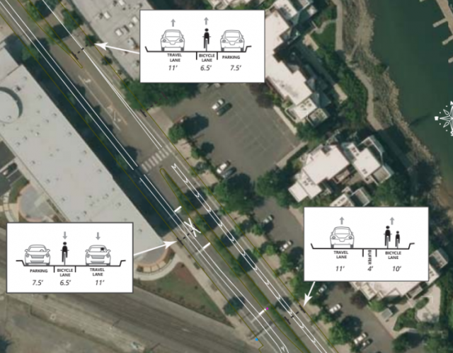
The secret: it’s removing an unnecessary passing lane in each direction between NW Davis and NW Ironside Terrace to create continuous bike lanes that will be, at their widest, 10 feet with a four-foot buffer.
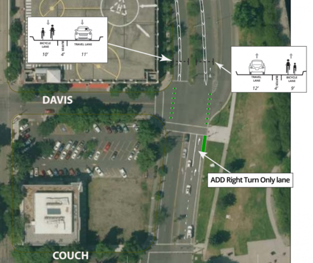
In the northbound direction, this will mean converting the rightmost auto lane of Naito into a right-turn-only lane leading to the Steel Bridge:
“In the northbound direction, half the traffic is exiting Naito onto the Steel Bridge,” the city wrote in a memo circulated to northwest Portlanders Wednesday. “The provision of a right turn only lane will facilitate this. In the southbound direction, Naito is already one lane north of Ironside Terrace; with adjustments to the traffic signal timing at Everett, Davis and Couch the traffic should flow well.”
This is basically the same trick that the Oregon Department of Transportation realized it could use to close a different notorious bike lane gap on Southwest Barbur Boulevard. (By the way, stay tuned: we’ve been in correspondence with ODOT for weeks to get an update on that project.)
It’s happening now because the city just repaved the pockmarked pavement between NW Davis and 9th, which in its words “provided a ‘clean slate’ to restripe the roadway.”
The city says the redesign will have the added benefit of reducing excessive speeding here, presumably because the single lane will remove the temptation for anxious people to weave around other cars freeway-style in order to get to wait one or two spaces ahead at the next red light.
Though this stretch of Naito has a 30 mph speed limit, the “85th percentile speed” here is 38 mph southbound and 36 mph northbound. This is a standard way of measuring typical traffic speeds that means 15 percent of autos are moving faster than 38/36 mph.
Advertisement
Closing the so-called “Naito Gap” was identified as a priority in the city’s 2010 bike plan and last year’s West Quadrant Plan. Northwest of this area, Naito and 9th sees an estimated 1,600 bike trips daily, a number that seems likely to increase with this new direct connection to the central city.
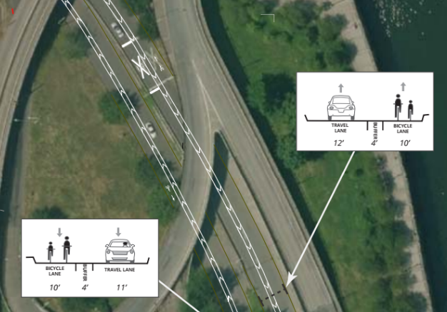
Here are some more details from the new cross-section, proceeding north:
And over the crucial railroad crossing, where the roadway narrows beneath the Steel Bridge. This is the site that has given the city so much grief as it has tried to get bike lanes to cross the tracks at safely obtuse angles, a difficult trick when there was minimal road space to play with:
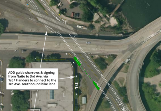
and finally north of the Steel Bridge overpasses:
Converting the unnecessary passing lanes to wide bike lanes (which the city also did last year on NE 15th/16th in the Lloyd District, with no apparent ill effects) will also greatly improve the safety and comfort of walking across this part of Naito, because there’ll be no more “double threat” when a stopped car in one lane creates a blind spot for the second lane in the same direction. This is one of the major sources of death and injury for people walking.
It’s a major step toward reducing car dependence in northwest Portland.
There’s one possible tradeoff here: when a train is going through, Naito will have less room to store cars, which could cause a queue running south on Naito. But there’s only one significant crossing of Naito that might be blocked — the Steel Bridge onramp at Davis — and it shouldn’t be hard for people to keep their waiting cars far enough apart to keep that clear for people heading over the bridge. It’s notable that Union Pacific Railroad and the ODOT’s rail division have apparently signed off on this plan.
The queue will also actually have an upside for people driving: people planning to use Naito will get advance warning when the train is blocking their path in time to take a detour.
All in all, this looks like fantastic news for closing a gap we’ve been reporting on since Naito first got bike lanes in 2007. In the years since, the riverside north of the Steel Bridge and the north Pearl District further northwest have added thousands of new homes, all of which will now get a dramatically more comfortable biking option into downtown, the central east side and beyond.
This also sets up a greatly improved connection to Naito for the future Flanders Neighborhood Greenway, which will be made possible by the new Flanders Crossing Bridge that seems likely to be funded by the Oregon Department of Transportation’s Connect Oregon program. That bridge would be due to open in 2019, creating the first modern, low-traffic bikeway between the Northwest District and the city’s riverside network of bike paths.
In other words, it’s a major step toward reducing car dependence in northwest Portland. And it’s supposed to happen in a matter of days — in time for northwest Portland to become one of North America’s best places to get around by bike sharing.
“A work order has been issued but we don’t have an exact date yet for when this will be done,” city spokeswoman Hannah Schafer said in an email Wednesday. “Rainy weather the next few days will likely slow down any striping projects.”
— Michael Andersen, (503) 333-7824 – michael@bikeportland.org
Our work is supported by subscribers. Please become one today.




Thanks for reading.
BikePortland has served this community with independent community journalism since 2005. We rely on subscriptions from readers like you to survive. Your financial support is vital in keeping this valuable resource alive and well.
Please subscribe today to strengthen and expand our work.
Anything in the plans about improving the connection from the lower deck of the Steel to Flanders? That’s the ‘gap’ I’m concerned with.
It didn’t get funded in the latest round of Connect Oregon, so this gap will continue. Please fight for this connection during the upcoming Central City multimodal project.
Yeah, that’s a different gap not addressed here, except in as much as you’ll be able to take Naito now.
The project FAQ says:
“What about the Flanders Crossing project? Is that still going to happen?
Yes. There will be further improvements to NW Naito and NW Flanders in the future to connect the NW District to the Steel Bridge and Waterfront Park for people walking and bicycling.”
https://www.portlandoregon.gov/transportation/article/583050
Awesome! A bike lane to the right of a right-turn-only lane. That’s sound planning right there.
Do we know for sure that PBOT isn’t installing a protected right turn signal and a bike signal here?
No, we don’t. I admit to being overly cynical.
This was my thought too – there’s already a hanging signal here for both auto lanes, so presumably it would be possible to create a red-arrow phase for right-turning cars. I’ll find out.
Except it is legal to turn right on a red arrow in Oregon…
Not if there is a “No Turn on Red” sign, like there is at every other protected right turn signal when there is a bike lane present.
I’d still be inclined to take the lane in order to cross that intersection. Given the nature of traffic there at rush hour and the tendency of drivers to completely choke the intersection trying to get a spot on the Steel Bridge, it’ll be a zoo to get through even with the new striping.
luckily we’re legally allowed to take the lane when the bike lane is to the right of a turn lane…
In an environment where PBoT has documented that the 85th percentile speed is 20% over the posted speed limit, do you really think motorists will obey a “no turn on red” sign?
In an environment of lax or nonexistent law enforcement, the engineering really, really needs to be spot on and minimize conflicts. A right turn lane to the left of a bike lane fails miserably, imo (and that of the FHWA and even ODOT for that matter).
Welp, I’m glad y’all asked. More coverage coming tomorrow.
Any idea why they won’t be striping a transition across the right turn lane? It seems like this would be preferable to a right hook lane, even if it is painted green.
Tremendous news! PBOT deserves to be commended for getting this long-awaited project finally implemented, even when dealing with difficult partners such as ODOT Rail and Union Pacific. This critical improvement will let bicyclists avoid the crowded waterfront path when coming from the north into downtown on Naito.
One question I have is what does the future of Naito look like south of Davis now that this project is put in place? Does this mean that a permanent better Naito would have two one-way protected bike lanes as opposed to the two-way configuration we have now? Otherwise, you’d have an awkward transition for people riding bikes southbound.
Yeah, that right hook is already a problem. I just take the lane, but it’s always an interesting negotiation, given the speeds.
I have a bike or two that are problematic across the tracks, which are at a 45 degree angle (give or take). And I’ve seen people crash there on the Worst Day ride. This helps in a way, because I can weave in the bike lane to make it more perpendicular.
There’s no contact information- is there someone/somewhereI can discuss my concerns with the right turn lane?
Here we go: https://www.portlandoregon.gov/transportation/71148
If you have any questions or concerns, please contact Scott C* .. or email at: s*@portlandoregon.gov
Click link above, I don’t want to be responsible for spam.
I’m more concerned about the merge across the southbound bike lane onto the Steel Bridge on-ramp. Motorists can take that ramp at high speeds and the merge zone in this design is long enough that I don’t think it will compel anyone to slow down here. This ramp should be demolished anyway and I hope it happens sometime in the near-future.
No protection though?
yeah, where’s that proclamation? there’s certainly room.
A 14-foot bike lane certainly has plenty of room. I understand the decision not to use more permanent concrete since maybe Better Naito might happen some day, but at least put some vertical posts in the buffer area.
I’m partial to the “turtle bumps” used for MAX by the stadium. But (as I said in an email to Scott) “well-maintained wands” would be nice at a minimum.
Just like clockwork….
Didn’t want to disappoint you. 😉
Yes for Northwest!
I hope at some point PBOT also addresses Naito’s disappearing bike lanes at the Salmon Street Fountain. It would be nice if that stretch went all the way to SW Harbor Way, which connects to the separated path, which eventually connects to SW Moody.
Having to turn into Waterfront Park and use that shared walkway is slow, has blind spots, and lots of foot traffic. It gets dicey negotiating throngs of tourists and tweakers.
Tweakers and rented surreys, which are the bicycle equivalent of a SUV in a motorcycle parking space.
Let’s not talk about Surrey buggies (which seem to be frequently be driven by people who look like they’ve never ridden a bike, with their kids dangling off the front racks). It is difficult to talk about them without using a string of four-letter words.
OMG yes. Those things are an F-ing scourge.
Yes, a ride the dux franchise, a two-stroke scooter rental shop, and a bunch of pokpoks would be so much better?? Personally I think Pendleton is a nice place for tourists. But as much as I hated those signs, in this case I have to say fast bikes, use Naito.
I’m happy to have tourists and surreys in Portland. I really dislike surreys on the Steel Bridge or Hawthorne Bridge. It’s ridiculous, especially on Steel.
only northbound…
southbound the 35mph zone that started at the Broadway bridge doesn’t end until you’re south of Couch…
so you have a .3 mile stretch where the speed limits on each side of the road are different…
maybe there used to be a 30mph sign at the southbound Steel Bridge tracks but I’ve never seen one…
sloppy civil engineering…
Why do you keep calling it a passing lane? Naito (HWY 99W) is a two lane road in both directions through the entirety of downtown.
Immediately connected to the segment in question, Naito looks like this:
https://goo.gl/maps/W3ZQcAs4gKP2
The transition from one to two lanes in each direction happens in the vicinity of the railroad crossing – all this project does is shift that point a little farther south.
weird, I always thought that “downtown” was only south of Burnside and just now see that it extends up Naito and Broadway to the Broadway bridge…
The Highway 99W designation on Naito Parkway never went any further north than the Steel Bridge. The whole issue is moot now since all of 99W north of SW Barbur Boulevard was terminated as a state highway and returned to the City about 20 years ago.
so they’re also going to put in a pedestrian crossing?
I see no crosswalks in the new design and there are currently signs prohibiting you from crossing through parts of that section…
a crosswalk (or three) would be great so you could get across the road when there’s a train blocking your path and you want to wind through town rather than wait…
Yes…the crossing project was submitted for Connect Oregon grant funding and PBOT was not successful.
ftp://ftp.odot.state.or.us/outgoing/ConnectOregon/Region%201/1B0403_Naito%20Parkway%20Railroad%20Crossing%20Safety%20Project%20FTP4.pdf (see page 35)
Will you advocate for it during the Central City multimodal project?
Note to PPB: PBoT has data indicating that almost all motorists are speeding on this stretch by a significant amount. Would it be too difficult to enforce the law, or is constant CARnage just fine by you.
Striping in a right-hook is substandard as can be. What are they thinking? It wouldn’t be difficult to use the standard of having the right turn lane “appear” to the right of the bike lane so that motorists know they must cross over, and thus will be more inclined to yield (and would be 100% liable for any collision).
Even when something is done for cycling, it always seems to be done just poorly enough that it doesn’t really work.
Never never never put a “go-straight” lane to the right of a “turn-right” lane. This would never be acceptable for cars; why is it ok for bikes?
Amen to this. It’s even worse than having a combined “sharrow straight and car turn” lane, because it forces bikes to go to that little bike lane.
If done right (separate signal phases) it’s tremendously more safer than a crossover, which never usually function as intended. Drivers will either speed past bikes, or people biking take the lane well beforehand (see N Broadway at Larabee.)
Speeding is an institutionalized aspect of road design guidelines.
http://safety.fhwa.dot.gov/speedmgt/ref_mats/fhwasa10001/images/speedconceptscover.jpg
So happy for this! We live in this hood, and my pet peeve is the dangerous pedestrian and bicycle crossing conditions at the crosswalk just north of the Steel Bridge on Naito outside the McCormick Pier mini-mart, where users must currently navigate four lanes of high speed traffic to get to the other side of the road.
What’s the reasoning for no protection?
probably so they still have space for breakdown. If jersey barriers were used and a vehicle breaks down anywhere in this stretch, it would create a complete blockage of the road. Even emergency vehicles would be unable to access the street.
I can’t believe so many people are complaining about an obvious improvement — this is exactly what keeps way more from getting done in this town. Much better to implement the improvement and then continue moving forward.
I ride this section every day and would observe the following:
1) There is no bike lane there now so anyone who goes straight already goes through a right hook situation and then play with speeding cars jockeying for position before they reach the light
2) The worst part of this section and the area where speeding is the biggest problem is the part that would become a bike lane
This is way better than what we have now and time wasted pushing for lights/barriers/whatever here would be better spent doing simple cost effective improvements in far more dangerous locations — of which there are many in this town.
I’d argue the exact opposite: people in this town being okay with half-assed infra is what prompts the city to install more half-assed infra.
I don’t think it’s half assed at all. What they have is cheap, effective, and a major step forward.
Some things suggested here are a step backwards for me. Take the protected light idea. All that does is guarantee cyclists will stop in the bike line which then blocks it while bunching up cars that will force their way onto the bridge when they get the green rather than simply merge with cyclists.
Cyclists who don’t like traffic already have a non road option, and the light only makes the presently efficient road option slower than the nonroad option if you don’t get the light.
Cycling infrastructure should be about getting as many bikes moving around as many places as possible. When we overengineer just a few areas, the result is a handful of places where movement of both cars and bikes is gummed up while everywhere else is practically unrideable to all but the most dedicated.
Is it effective though? We won’t know for sure until it’s built. What we do know is that buffered bike lanes like this around curves are often encroached upon by drivers. Given that knowledge, why are we still designing bike lanes that encourage this behavior?
I’m ok with people complaining about “better” when we could have built “best”… if there was a future plan there’d be less complaints… but building sub-par infrastructure at this point, when the cost to make it twice as good is negligible, comes across as very poor civic planning…
WOOHOOO at least one of the gaps is closing FINALLY!
Michael wrote:
“There’s one possible tradeoff here: when a train is going through, Naito will have less room to store cars, which could cause a queue running south on Naito. But there’s only one significant crossing of Naito that might be blocked…”
&
“The queue will also actually have an upside for people driving: people planning to use Naito will get advance warning when the train is blocking their path in time to take a detour.”
This is only a positive for people in cars crossing the train tracks.
I’ve noticed that when there is a freight train crossing Naito, car traffic queues up south from the tracks to Davis, but not south of Davis. All people in cars, when they see there is a train blocking Naito, choose to go west on Davis or east on the Steel Bridge. i.e., if you know that there is a train there, you’ll take a different route.
It stands to reason, then, that the two lanes of cars stuck waiting for the train would have preferred to have known about the train so they too could use an alternate route.
With the restriping, the number of people in cars that get “stuck” waiting for a train will only be 1/2 the number today, because there will only be one lane to queue up in, rather than two.
And it will be much better for people on bikes, too.
Thanks PBOT,
Ted Buehler
I like this design all the way around.
Big lanes for bikes. Wide enough for faster people on bikes to safely overtake slower people on bikes.
The only issue is that right-hook problem, as others have mentioned, at NB Naito and the Steel Bridge. I hope they install one of the classic “right turn yield to bikes” that shows a diagram with the green bike lane.
Like eastbound approaching Larrabee on the Broadway Bridge
https://goo.gl/maps/adFFsbhrKXu
Rather than the generic replacement sign that doesn’t give a “picture” of the yielding maneuver.
http://www.fhwa.dot.gov/environment/bicycle_pedestrian/publications/separated_bikelane_pdg/images/mutcd_r10-15.png
Ted Buehler
Another way to configure the NB Naito at Davis is this:
PBOT proposal:
* Naito’s right-hand through lane becomes a right-turn only lane, while the left lane continues northbound as a through lane.
* A left-turn only lane appears just before the intersection.
Alternate proposal:
Graphic here: https://www.flickr.com/photos/11599639@N03/28063657062/in/dateposted/
* Naito’s *left-hand* through lane becomes a “left-turn only lane, while the *right lane* continues northbound as a through lane.
* A *right-turn* lane appears just before the intersection, and people in cars will need to yield to bikes to get in the right-turn lane.
I would think this would work a lot better than the PBOT proposal. I can’t think of any other place in the city where they designed a right-hook right turn lane. There was one westbound on Broadway at Larabee, but they reconfigured it because it was a nightmare. See the “before and after” photos here: http://bikeportland.org/2011/06/17/city-changes-dangerous-lane-configuration-on-n-broadway-55047
Ted Buehler
I don’t understand the angst behind a right hook right turn lane. Cyclists already must treat every intersection where a right turn is possible as such. Anyone who does otherwise is guaranteed to crash.
As a practical matter, a right hook right turn lane is safer than a regular intersection because you know where the cars are going. If you didn’t take the lane and the car overtaking you isn’t slowing down, you know you need to brake. If it hangs back, you know they’re letting you through.
Compared to other parts of the country, Portland drivers are already pretty good about not hooking cyclists. A sign reminding drivers to yield to cyclists will help, but we all know that some drivers will ignore or not notice it.
On an aside note, a helmet or glasses mounted mirror is an excellent defense against the right hook since you can tell by a vehicle’s movement what it will do whether or not it signals.
If room is available for a transition, it is best practice to use it. Say what you want about riders and drivers in Portland, but right hooks have been responsible for a large portion of the cycling fatalities in the city. History has shown us that this is a bad design.
What you’re saying is, cyclists should recognize bad design and ride accordingly? Why not just eliminate the bad design in the first place? We know how to design safe intersections.
It’s not bad design. Every intersection, driveway, alley, etc is a place where someone could right hook you or pull out. It is an inherent threat of being on the road.
Cyclists need to take some ownership of their own safety. Every day, I see riders coming from behind to pass vehicles on the right when there is no clear indication as to what the driver will do. The bet they’re placing is that the vehicle is either going straight or that the driver is watching on the right for cyclists coming from behind.
Riding as if the most common sources of crashes doesn’t exist is both stupid and dangerous. Just as it is irresponsible for a driver to simply move along with the presumption that everyone else will do what they’re supposed to, that is also true of cyclists.
We are traffic. Just as the only good driver is a defensive driver, the same is true of cyclists. Because of the physics involved, the only way to stay safe year after year is to ride like everyone is trying to kill you, but don’t take it personally.
That section of Naito is a cakewalk as is the downtown area in general. If we really want to encourage more cycling, we need to make it friendlier to those in other areas and who have more than a few miles to cover.
TLDR: apparently the main cause of cycling vs. car collisions is cyclists’ inattention.
This is only because we live in a world of bad design and you’ve simply gotten used to it. It is possible to design infra to minimize conflicts. Placing the responsibility of safety solely on the cyclist is missing the point entirely.
It should be designed to minimize conflicts, but people still have to use common sense. It is neither feasible nor desirable to have barriers every place a car might right hook someone.
If we’re going to be serious about cycling infrastructure, it needs to be about more than dinking around the center which already is in excellent shape.
It should be much easier than it is to ride from Hillsboro, Tigard, Tualitin, Wilsonville, Lake Oswego, Gresham, Vancouver, etc. These are all very rideable distances for a daily commute and a bike is faster than a car at rush hour, but hardly anyone does it.