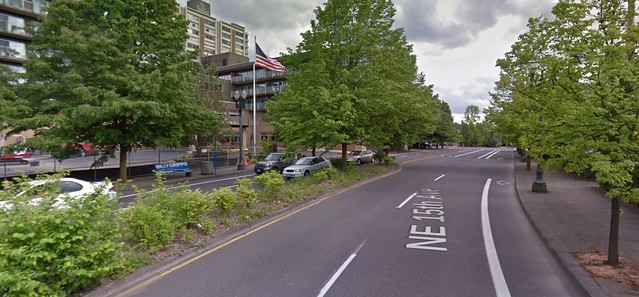
(Image: Google Street View)
The divided four-lane street that runs between the Holladay Park Plaza senior-housing skyscraper and the Lloyd Center Mall is about to get a lot easier to cross.
For most of the distance between Northeast Multnomah and Halsey streets, two of the four current general travel lanes on Northeast 15th/16th will be converted to massive five-foot-wide cross-hatched buffers. The bike lanes, meanwhile, will be widened from five feet to seven. Finally, a zebra crosswalk and median refuge will also be added between the Holladay Park Plaza tower, just east of 15th/16th, and the mall parking lot, just west.
The link is significant to the city’s biking network because the rapidly developing Lloyd District currently offers no low-stress biking connections between the Multnomah Street protected bike lane and the neighborhoods to the north, including the commercial district on Broadway and Weidler.
15th and 16th is currently so “overbuilt” with excess traffic capacity, city traffic engineer Andrew Sullivan said Wednesday, that even if auto traffic on the street were to double, the planned restriping wouldn’t lead to any additional travel delay for people driving compared to what they see today.
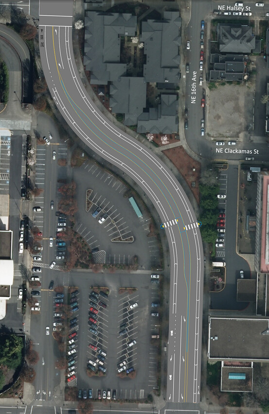
(Click here for full PDF, including the block between Halsey and Weidler.)
The crosswalks are being built now; the restriping will take place after the street comes up for regular repaving this July. The infrastructure budget of about $40,000 comes from the local business association, Go Lloyd, which receives about half of the district’s parking meter revenue to spend on projects that reduce the need for driving.
Sullivan and project manager Chris Armes said the restriping will improve walking safety by removing the “double threat” that occurs whenever a street has two lanes in the same direction. When one car yields to someone in a crosswalk, a second car sometimes won’t.
“He says, there’s no way. The mall’s not going to support this. And there’s a silence in the meeting, and we’re like, Oh shit, this is it.“
— Kiel Johnson, local resident on project committee
The city had previously considered its standard treatment for such streets these days, a rapid-flash button-activated beacon, but discarded that concept because Go Lloyd couldn’t afford it.
But the one-lane design will actually be better than a beacon, Sullivan said.
“Rather than doing one small improvement with a really big price tag, it actually benefits people no matter where they decide to cross,” he said.
The design will essentially result in 12-foot-wide buffered bike lanes, maybe the widest such in the city. Sullivan said the city decided against physical protection to keep the project quick and simple.
“If it becomes a problem where people are driving in the bike lane, that kind of thing, we can always come in with operational funding and put in signs, striping, more planters,” he said.
Like on nearby Multnomah Street, the new southbound bike lane will end as it approaches the intersection, being replaced with a right-turn lane marked with a sharrow. Sullivan said this so-called “mixing zone” was installed because bikes will have to mix with motor traffic anyway because TriMet’s No. 8 bus, which uses this stretch, has a stop north of Multnomah on 16th.
“Portland State University’s ‘Lessons From the Green Lane Project’ study looked at mixing zones similar to those proposed on this project and found that they have a very good safety record in low-speed environments such as NE 15th/16th Ave,” Sullivan wrote. (On the other hand, the same study found that, actual safety aside, 25 percent of current bike users feel generally unsafe while pedaling through the mixing zones on Multnomah.)
Advertisement
Neighborhood advocate: Redesign only got consensus because it wasn’t seen as a bike project
Kiel Johnson, a Lloyd District resident and biking advocate who took part in the meetings planning for this project, said he believes the plan nearly died when Dennis Henderson, the Lloyd Center Mall’s operations director, learned in a neighborhood meeting that it would reduce the number of auto lanes on a nearby street.
“He says, there’s no way. The mall’s not going to support this,” Johnson recalled. “And there’s a silence in the meeting, and we’re like, Oh shit, this is it. You could just see the panic in everyone’s face.”
But Johnson said the other people on the committee, all of whom favored the project, explained to him that it was the traffic signal, not the number of traffic lanes, that actually restricted the street’s capacity. Then the group walked outside to look at the street.
“There was already, like, a place where people had trampled the vegetation,” Johnson said. “You could see that there was a pedestrian island defacto there. … And by the time we’re outside, the guy from the mall is making suggestions and he’s on board. … I think maybe he just felt a little caught off guard.”
Johnson said it was a lesson for him in how to sell a project to skeptical neighbors.
“I think if the city had put on the meeting and said, ‘Okay, we’re going to put on this road diet,’ it wouldn’t have worked,” said Johnson. “I think the biggest thing was there’s already a community group there that was all on board with this project, and it was the community asking for it and not the city trying to make it happen.”
Another key factor in getting the mall’s approval, Johnson thought: no one mentioned bicycling.
“The whole meeting, it wasn’t about bikes at all; it didn’t talk about bikes or how this would make things better for bikes,” he said. “Which I think is so sad.”


Thanks for reading.
BikePortland has served this community with independent community journalism since 2005. We rely on subscriptions from readers like you to survive. Your financial support is vital in keeping this valuable resource alive and well.
Please subscribe today to strengthen and expand our work.
I’ve trampled through that vegetation in the median many times. I’m glad the goat path was noticed! I’ll take a mid-block crossing over an intersection crosswalk any day.
It is not “overbuilt” at all. This whole area could have tons more housing. That areal view shows blacktop. Why do these traffic engineers continue to try to push a rhetoric of sprawl?
The engineer isn’t referring to housing or density as being overbuilt. He is referring to the street and traffic infrastructure. Meaning that the road has MUCH more capacity than is currently being utilized, which is why they can change the configuration with zero impact to automobile travel times.
Thank you! Great hack Andrew Sullivan!
Can we get it at NE 21st and Pacific while you’re out there?
Yes, this is correct about the context of the exchange. I’ve added a clarifying phrase above.
They’re referring to the street as being overbuilt, not the neighborhood. As in, there are way more lanes in the street than are necessary relative to measured vehicle traffic. So actually, you are on the same side.
If that’s what was meant, cool. However, with many people on both sides attuned to dogwhistle terms, they should really clarify that as a traffic engineer exactly what they mean when speaking to media.
Anyway, I cannot wait until Lloyd center gets reverted back to the old small blocks and gets mid/high rise. That black top needs to go. This bike infrastructure is a great boon to the area once that density goes in.
when a traffic engineer says that the road is overbuilt then most people will likely think he’s talking about the road…
Most people don’t even care, but I still think the distinction was important given this publication’s focus on infrastructure AND dense housing as a cohesive ethos.
“this publication’s focus on infrastructure AND dense housing as a cohesive ethos.”
That’s what you get out of this site?
Jeg, I think you are interpreting it as “overbuilt with housing” – is that right? I’m pretty sure he meant that the roadway is overbuilt – it has way more capacity (= lanes) that are needed to serve today’s users, or even apparently a huge growth scenario. So, yes! More housing can be built and this new, more human-friendly design will still function fine. (From an auto perspective, that is. If that’s important to you.)
I am actually super glad this is being done. I was just concerned about working since we have a housing shortage and this district could support high rises with mixed use.
working=wording.
Good news! Looks like another 980 units are going in right there (in place of the Lloyd Center Cinema 10).
http://www.portlandmercury.com/BlogtownPDX/archives/2015/05/12/so-long-lloyd-cinemas-you-wont-be-missed
I’m still disappointed at the number and proposed design of mixing zones. Would have been an interesting opportunity to try a design that actually deals with intersection design and signal phasing to keep “separate” facilities actually separate from vehicle traffic.
I mean, I get it: signals and intersections are really expensive (far more than the project could handle), and local studies show that mixing zones operate safely. But it still kills the whole notion of having a low-stress design. So what we end up with instead is a design that will be an improvement for the people who already bike in mixed traffic, but won’t be considered “safe” to any concerned potential new bicyclist.
Bufferent biek lanes are not acceptable as an “upgrade”. They should have physical protection.
Buffered bike lanes are not acceptable as an “upgrade”. They should have physical protection.
Why isn’t the crossing placed closer to the existing sidewalk connection to where 16th turns into Clackamas?
Did the 1000 apartments soon to take the place of the Lloyd movie theater come up in the meeting? (not to poopoo the current state of car traffic around there)
Good question for PBOT since the original concept was at Clackamas for goat path and sight distance reasons.
ingress and especially egress from the cinema parking lot creates a lot more difficulty than a thousand unit apartment probably will
I’m really excited to watch the evolution of the Lloyd District from a 1960s auto oriented business district into a true mixed use neighborhood, with great infrastructure for bikes (and peds / transit). The city kind of missed the ball regarding in the Pearl District, and did OK with South Waterfront, but the Lloyd has the potential to be the best Central City neighborhood for cycling. Bring on the Green Loop and the Sullivan’s Gulch trail!
It’s still full of people with 1960’s mindsets. I work in the area and I’m nearly hit daily on my bike.
The advantage that the Lloyd has over Westside districts is the presence of a number of wide right-of-ways. Easier to re-purpose these auto-oriented arterial and collectors to complete streets.
I am concerned with a few parts of this project. For one, the bus / bike interaction still exists at both bus stops on that stretch of road.
There are also no bike lanes North of here, so it doesn’t really connect to anything.
This isn’t a “major upgrade” for biking. At best, it’s better for walking. It’s not really any better for people on bikes or on line 8, and as a commuter who chooses between biking and taking line 8 to work, I know this won’t do much to benefit me, regardless of the mode I’m using.
And there’s nothing preventing people from driving in the bike lane. I am guessing that some Clark County driver will run over someone in the bike lane before the end of the year.
Vertical delineators in the buffer, particularly approaching the inside curves people tend to cut, would be of benefit.
Well, it connects to the existing bike lanes on NE Broadway / Weidler. And if the city ever decides to pick up the 2030 bike plan to see what’s in it, NE 15th Ave is meant to have “separated in-roadway” facilities all the way up to NE Lombard St.
I’ve been trying to get the city to do something about NE 15th, but since it will require parking removal, they will not touch it. Even though all of the houses on the road garages or driveways and the commercial areas are very small, the people who use public right of ways to store their vehicles win again.
12 feet of buffer + bike lane isn’t any “better” for biking than the no buffer + 5 foot bike lane there now? Plus the option of putting planters in the buffer if it proves necessary? Short of entirely closing the street to cars, not sure how much “better” it could be, consistent with the limited budget available.
Okay, I’ll admit that it’s better… if you’re in that specific stretch of road. And if someone is not driving or parking in the bike lane. And if no one tries to run you over to make a turn. And if there are no buses going through at the same time you are.
However, it would be much, much better if there were any physical separation, floating bus stops, and connections to places North of there.
FWIW, no arguments here that 15th should get a sweet bike lane all the way north … but I think a comfortable link to Broadway-Weidler is a pretty big deal, especially if they’re on the short list for protected bike lanes, which seems to be the case. Getting bike lanes on 15th that connect with this and then Multnomah would be basically the awesomest thing ever for inner Northeast, but it’ll never happen without parking removal.
It’s not “comfortable” though. It has bus / bike interactions all up and down it and I’ve personally been squeezed between vehicles turning out of driveways and same-direction motor vehicle traffic. This design doesn’t appear to change anything North of Halsey, where many issues occur.
And its an upgrade for Safe Drivers…who get tired of being passed on the left and right by Unsafe Speeding Drivers.
Also, the fact that we can’t even mention bikes without massive backlash is a serious issue. The city needs to take bolder steps and work though opposition instead of caving to (usually business owners’) interests. Sorry, but the owner of a mall doesn’t get to decide what’s good for the neighborhood.
I too am baffled as to why the owner of a mall has such high clout in the decision-making process…
Can we take a hard look at ourselves and ask what in the name of Robert Moses was the city thinking when they rebuilt this street less than 20 years ago? That weirdo, overly-wide, uncrossable, sweeping, high-speed suburban curve was put in back in the early 1990s, if I remember right. And now we’re trying to undo it. Sigh.
probably the same reason they build a mall with a parking lot that’s over half-empty most of the time…
misguided traffic projection techniques dating back 50 years…
I know the answer! According to Rick Gustafson, this street was built like this as part of a scheme to … reduce traffic congestion on Multnomah, Holladay, etc.
Yes.
In an interview last year, he told me the city was following the same strategy it had pursued in the 1970s with I-405 downtown: in order to increase development in a commercial area, you need to reduce congestion. (This is how the thinking went.) How do you reduce congestion? You lure through traffic to loop around that area instead of going straight through. How do you lure through traffic away? You vastly increase the capacity of nearby roads, thus making it possible to drive really fast on them.
All I can say is: We’ve come a long way, baby.
1) That makes sense knowing the flyunder ramp that feeds it
2) That was an insane way to design roads and I am glad it is going away
3) Glad we have Rick G. around to explain historical developments like this.
I found a historic aerial photo from 1994 that showed a nice, standard grid, so the (expensive!) rebuild we are now unbuilding must have been some time after that.
Here is the street grid in 1990, taken from Google Earth – http://i.imgur.com/fkkZ4NC.jpg
There is also an immediate need for better temporary paths during construction. Here is an actual old lady with a walker–as opposed to the hypothetical ones often discussed in public meetings. https://twitter.com/SchonbergerBen/status/605577874955894785
What changes are being done between Halsey and Weidler, particularly for dual-lane southbound auto traffic? Is that going to become a left-turn only at Weidler (hopefully) in the left auto lane and the right lane becomes straight only?
Is there a direct link to this project page anywhere? This is my hood. So, I’m interested in what’s happening here.
Okay. I see the link to the full pdf as part of the photo caption now, which included the north of Halsey changes.
“The link is significant to the city’s biking network because the rapidly developing Lloyd District currently offers no low-stress biking connections between the Multnomah Street protected bike lane and the neighborhoods to the north, including the commercial district on Broadway and Weidler.”
Without any meaningul improvements north of Weidler, this statement will still be true after this project is completed. I consider 7th to Weidler to already be pretty “low-stress”.
I’m about as pro protected bike lane as they come, but I think this is a great location for a simple buffered bike lane.
Sure, I’d like some trees planted in the 5-ft buffer area (like this: http://imgur.com/mCreNz6) – but with a median, no door zone, no driveways, one lane of motor vehicle traffic, and a massive 8 ft biking area, this is going to be the nicest bike lane in the city.
An keep in mind that this is being paid for by the Lloyd district businesses, not the city of Portland.
Time to start supporting and thanking Lloyd businesses.
I agree completely. We need and easy way for other private sector groups to pay for small improvemtns like this.
I thought this was funded via meter revenue the City shares with Lloyd TMA.
A great improvement for the neighborhood’s seniors. They appear to have finished with forming the new curb ramps today where the crosswalk will be painted.
This is on my daily commute, and I think speed bumps would be good improvement well ahead of the new crosswalks, since the curving sightlines are poor, and cars hug the insides of the curves to maintain speed, although I’m hoping the lane reduction will lessen auto speeds here.
The problem of drivers cutting the inside of turns is endemic wherever a bike lane is on the inside of a curve. It is a natural thing to do, from the driver’s perspective. I have been wondering whether to ask PBOT to use rumble strips on the roadway, immediately to the outside of the bike lane painted line, in these situations.
Rumble strips are the corrugated lines milled into the asphalt that make your car rattle if you drive on them. They would definitely dissuade most drivers from cutting into the bike lane. However, they would also rattle the teeth from the cyclist who rides on them, thus “trapping” cyclists in the bike lane.
What do you think?. Rumble strips bordering bike lanes on curves, or not?
If actual separation with trees etc. isn’t an option, this might be a helpful second, particularly on the inside of curves as you said.
There will be enough room to avoid most hazards without leaving the bike lane, and there are no intersections, so I would think it a good trade-off in this situation. The rumble strip could also have gaps to escape through.
I remember a few years back the city discussing rumble-strips for the improvements to the NE 12th Ave Overcrossing over I-84 next to Benson High School, and there was concern about bike safety when encountering rumble strips. I’m not sure if PBOT has a stance on this or has *ever* used rumble strips for bike lane separation. I’m curious what the current expert thinking is.
every crosswalk should be raised…
What about emergency response times (-10 seconds per bump)?
Thank you Go Lloyd for funding a simple improvement like this that will result in a much better roadway to navigate for everyone! I’m really glad that this won’t take years to study, because it JUST MAKES SENSE! 🙂
Why would any pedestrian go that far out of direction to cross, what is now, a 1-lane per direction auto street with a median?
NE 15th/16th Ave. currently has two lanes in both directions–not one–in this section between Multnomah and Broadway. See this overhead photo:
http://tinyurl.com/pzx8xzp
In particular, a lot of seniors live in the recently-expanded Holladay Park Apartments, and they will use this improved this crossing for what’s already a high-frequency destination, the Lloyd Center Mall, where all-weather walking is just outside their door.
Currently, they either brave the dangerous not-yet-built crossing directly in front of their building, or else detour to the crossing at NE Mulnomah. As this article mentions, there’s already a highly visible well-established crossing pattern here through the trodden ground between plantings on the existing median and on the planted border of the mall parking lot.
Here’s a Google Streets image of the existing defacto crossing pattern:
http://tinyurl.com/ntwyuud
I would like to see a curb cut and crossing that would allow northbound/southbound cyclists to connect to 16th and Clackamas. I much prefer 16th to the tangled mess of 15th and Broadway/Weidler.
I fail to see what the big deal about this is. it is a slight improvement for bikes; a moderate improvement for peds trying to cross the street. evidently we have different definitions for what constitutes “major.”
While the 2030 bike plan exist, it seems to exist primarily to sit on shelves. Since 15th is in the comprehensive plan – why not push for a protected lane north of broadway (since that would be an actual improvement)? if not all the way to Lombard, at least up to Knott (for now, as a first step).
While i’m grateful for the slight-to-modest improvements for a three block stretch that already has a lane, the impact of this for cyclists is fairly negligible (and I ride this section several times a week). I never thought those three blocks were bad. they are certainly better than many places. rather than random piecemeal improvements, I’d like to see something more thoughtful, coordinated, ambitious and related to something they’ve spent time and money planning.
I’m continually surprised how many on this site don’t view road diets or lane reductions as big things. All we ever hear on here is how car is king, and then the city actually reduces auto capacity on a number of roads and many just shrug their shoulders and don’t appreciate it.
Although I’m with you that the few times I’ve ridden this I haven’t found it dangerous (but that’s an n = 2)
I hear you that road diets are important. My beef with this piece is that it is being heralded as a “major upgrade”, and I happen to think calling it major is not particularly useful. If we’ve lowered our expectations so much as to what constitutes major (and authorities think this is all we need to be satisfied), then we are in trouble, and we are not asking for enough. A major upgrade would be a bike lane all the way up 15th to Knott or Freemont. Three blocks where there is already a bike lane is a more modest improvement.
But for these 3 blocks (which is all the article is talking about) it is a “major” improvement. I guess it just depends how micro or macro you are looking. In the macro vision you make a fair point. I guess I look at things more piece by piece.
Yeah, this is what I was trying to get at with the headline – for these three blocks, it is a major change. For the city, definitely not a major change — though I was willing to argue a few paragraphs down that it’s a “significant” one because of the importance of connecting all those new housing units pouring into the Lloyd to the Broadway commercial district.
That said, feedback always appreciated.
I do have one major design comment …why is the City (PBoT) still doing “half measures” for cyclists approaching an intersection? Actually in this case…potentially a step backwards with the loss of the bike lane for a sharrow at the intersection? (Is it that important for safety to shift the bike lane space over to the median? the lane alignment does not look too out of whack if the bike lane was kept intact. Right?)
(Can anyone give me a bit more back story on the loss of the bike lane? I assume PBoT discussed the need for this big change at the meeting.)
PROPOSED:
So the the separated bike lane gets dropped and becomes a sharrow in the right turn lane only? Is this going to be all too common solution even in a Platinum Bike City?!
Should it at a minimum be a sharrow (sharrow with left turn arrow and shadow with thru arrow) in two other lanes too? Since bikes can make all 3 movements and drivers should expect to share the lane in each?
Here’s engineer Andrew Sullivan’s full answer when I asked the same question:
“There are a couple of reasons behind this. The primary scope of this project is the mid-block pedestrian improvement. The lane reduction is simply a tool to allow us to mark a crossing without expensive enhancements. Thus, one of our objectives with this project neutralize traffic impacts as much as possible. One of the big risks with the lane reduction is southbound traffic backing up from Halsey into the Weidler intersection. Maintaining a right turn lane to Halsey gives us storage space for a few right-turning vehicles and allows thru traffic to proceed smoothly in the event that right-turning traffic must yield to pedestrians in the west crosswalk. The presence of the mixing zone at Halsey is a conservative approach that greatly decreases the likelihood of excessive queues into Weidler.
The second reason related to Trimet bus service. Trimet has a far-side bus stop at south of Halsey. The new configuration will permit the bus to proceed thru from the right turn lane to access the bus stop across the intersection. We feel that the mixing zone is a better way of managing the bike-bus conflict at Halsey rather than having the two modes sort it out within the intersection itself.
The southbound right turn lane and Multnomah is necessary due to the Trimet bus stop which is located within it. We feel that the southbound mixing zone approaching Multnomah is an improvement over today’s configuration where the bike lane drops in favor of a right-turn lane and a 3’ bike lane picks up adjacent to the right turn lane downstream. The existing configuration does not meet any of our current design practices. Thus, it is being replaced with a design that we feel is acceptable and better delineates the expected behavior of both motorists and cyclists.
In both cases, right-turning volume is on the border of warranting a right-turn lane. Turning movement data collected at both intersections show approximately 75 right turns and 100 right turns in the southbound direction during the peak hour at Halsey and Multnomah respectively. Mixing zones have the distinct advantage of mitigating the right-hook collision. We acknowledge that some cyclists may feel less comfortable while riding through a mixing zone. Nevertheless, we feel that it is a safe configuration. Portland State University’s “Lessons From the Green Lane Project” study looked at mixing zones similar to those proposed on this project and found that they have a very good safety record in low-speed environments such as NE 15th/16th Ave. Thus, at this point in time, we use them in situations where we do not have the space to fully separate the movements.”
In a few years there are going to be so many additional people living in that area that traffic calming will happen without much intervention. Or, we’re going to have lots of people walking and on bikes made into victims.
The mid-block crossing is already installed. Just by chance I was there yesterday after reading this post and it was a happy discovery at the end of my wrong turn south on 16th. Kind of takes away the bitter taste I’ve had over there since that incident with the armored truck…