
(Photos: M. Andersen/BikePortland)
Part of NW Portland Week.
Someday, quite possibly two months from tomorrow, northwest Portland will finally land the biggest bike infrastructure investment in its modern history.
The Flanders Crossing bridge across Interstate 405 came close to reality eight years ago, then died amid shifting details and election politics. But it’s too good an idea to stay dead — and events of the last few weeks suggest that it may be on the edge of a breakthrough.
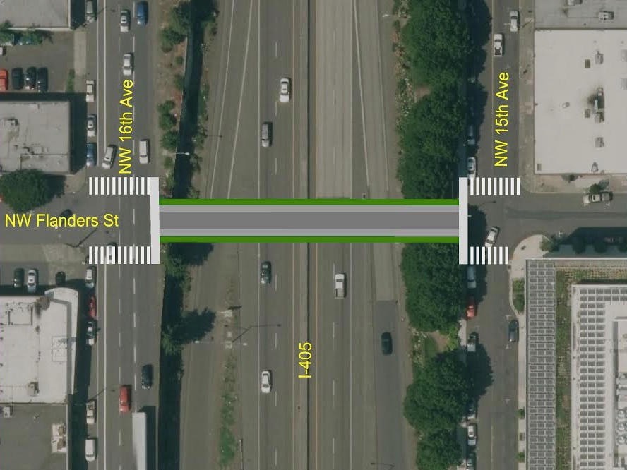
Last month, the new $5.9 million biking-walking bridge that would allow a continuous low-traffic neighborhood greenway from the Northwest District straight to the Steel Bridge via Flanders Street was scored third out of 22 biking and walking projects statewide for Connect Oregon, a Lottery-funded program that offers one of Oregon’s few sources for new off-road transportation investments.
‘The volumes would be huge’
If Flanders Crossing’s score survives the second and third rounds of project rankings, the City of Portland says work could begin next year.
On the day the bridge opens, the city estimated in its grant application, it’ll start drawing 3,000 crossings every day as people change their routes to avoid the uncomfortable freeway crossings at Everett, Glisan and Couch.
The city expects crossings of the biking-walking bridge to soar to 9,100 per day, more than summer bike counts across the Hawthorne Bridge.
Once a complete neighborhood greenway can be built on Flanders — speed bumps, stop signs and everything else that would give northwest Portland its first truly all-ages bikeway — the city expects crossings of the $5.9 million biking-walking bridge to soar to 9,100 per day, more than the summer bike counts across the Hawthorne Bridge and about five times the daily bike ridership across the $135 million Tilikum Crossing. By 2035, the city projected daily crossings would climb to 11,600.
“The volumes here for that Flanders Street project would be huge,” said Susan Peithman, who sits on the biking-walking modal committee that gave high marks to the project last month. “I don’t think there’s anyone who argues against the fact that it will have a significant impact.”
“Just look at the connections you would be able to make from the Steel Bridge all the way to Northwest,” said Reza Farhoodi, a biking advocate who co-chairs the planning and transportation committee for the Pearl District Neighborhood Association. “If you look at the Naito crossing and Flanders bridge in tandem, it really does make sense. It’s such a straight shot across the entire quadrant, from the West Hills down to the waterfront.”
Advertisement
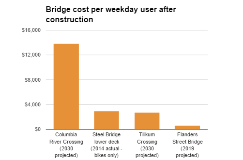
By 2019, bridge would have 21 times more users per dollar spent than the CRC would have had by 2030
Because the span is relatively short and the demand for better crossings of I-405 is already so high, Flanders Crossing would be one of the city’s most cost-efficient bridge projects.
That’s true even if you measure the 9,100 expected trips the bridge could be carrying in 2019 and compare that to the number of people using other bridge projects up to 15 years after their construction.
Part of the reason this bridge would be so well-used is that the Pearl District, just east of the proposed bridge, has been adding jobs just as fast as the area immediately west of the bridge has been adding housing. A Bureau of Planning and Sustainability study found the Pearl added 3,200 jobs from 2006 to 2013, despite the Great Recession.

But despite the bridge’s economic significance, $5.9 million is a lot of money in a state with many needs.
Backers of the Flanders Bridge say it’s unique because, unlike many projects, it can be paid for almost entirely out of the fees (known as system development charges or SDCs) that developers pay the city when they build new homes and workplaces.
The city would spend $3 million of development fees on the Flanders Bridge. It’s asking the state lottery fund to contribute the other $2.9 million.
Though there’s no law mandating that the fees be spent near new development, the purpose of the fees is to construct the capacity-boosting street improvements that will serve those developments. And northwest Portlanders point out that housing projects in their area have been filling Portland Bureau of Transportation coffers with cash that can’t legally be spent on road maintenance.
“By my math in the last five years, PBOT has probably collected over $7 million in SDCs just from apartments in NW and the Pearl,” said Iain MacKenzie, a northwest Portlander who publishes the development-tracking website NextPortland. “As far as bike infrastructure goes we’ve gotten a diverter at NW 10th & Marshall and a re-striping of NW Everett.”
State committees will decide project’s fate

(Image: Portland Bureau of Transportation)
If Connect Oregon helps pay for this bridge, it’d be Portland’s biggest payoff yet from a state law, unexpectedly won by the Bicycle Transportation Alliance in 2013, that let the state use lottery money for biking and walking projects of economic significance.
According to the city’s Connect Oregon grant application, PBOT would put up $3 million of its SDC funds for the Flanders Bridge. It’s asking the state lottery fund to contribute the other $2,877,000.
The next step in the state decision process is a regional review committee meeting on May 2 at ODOT’s regional headquarters. If the project scores well there, it’ll be positioned well for the state’s final review committee on June 14-15.
If cost-efficiency and economic payoff aren’t enough to carry the day there, we reported in December that the city and other bridge advocates have one more card to play on the bridge’s behalf: at 24 feet wide, the new bridge would be able to carry ambulances, fire trucks and construction vehicles.
The idea isn’t to open the bridge to big rigs under normal circumstances. But because the span would be built to modern seismic standards, someday soon Flanders Crossing might not just be the best way to get across Interstate 405.
It might be the only way to get across Interstate 405.
“It’d be pretty much the only bridge left standing if we ever had a 9.0 earthquake,” Farhoodi said.
— Michael Andersen, (503) 333-7824 – michael@bikeportland.org
Our work is supported by subscribers. Please become one today. .


Thanks for reading.
BikePortland has served this community with independent community journalism since 2005. We rely on subscriptions from readers like you to survive. Your financial support is vital in keeping this valuable resource alive and well.
Please subscribe today to strengthen and expand our work.
I love the idea of a bridge on Flanders. I also feel it’s necessary to compare alternatives. 6 Million can go a long way. How much would fully separated bike lanes on Everett and Glisan (say from 13th to 19th) cost comparatively?
How useful would separated bike lanes on Everett and Glisan be if they only went from 13th to 19th? For it to be a really useful corridor it needs to stretch from 24th to the the Steel Bridge. Placing the facility on Everett / Glisan would involve removing a general travel lane or parking on one side of both Everett and Glisan. PBOT hasn’t shown any willingness to do either.
Fully protected bikeways that still have right or left hook issues at every single intersection? I’ll take a greenway and a dedicated bridge over that any day. And you have to consider the added value for pedestrians. We need projects like this that reconnect the urban fabric that the freeways have destroyed.
Implement protected intersections and the right/left hook issue goes away. This is a solved problem.
The protected intersection (the pavement, concrete and striping) itself does nothing to keep someone from turning across you.
Perhaps you’re really talking about the additional signal phases. In that case, yes. Making a cyclist stop at every intersection and wait for a light could keep you from getting hooked.
Riding in front of the car behind you works too, is faster and costs no money.
The protected intersection places the bicycle rider in clear view of the driver and the lengthened curb forces drivers to slow down.
I don’t think these intersections (except for the freeway onramp intersections) have room for a true protected intersection. And by the time you add a bunch of protected intersections, you will be spending more than you would spend on the bridge. And, again, the bridge serves several other purposes, the biggest one being the reconnection of the street grid for pedestrians and cyclists.
Protected intersections don’t take up any extra width.
The video after that one is really good. Wow.
http://tinyurl.com/zdt382k
Adam,
What street are you discussing? the video link you provided was a street with existing bike lanes. Flanders is not that street. Protected bike lanes on Flanders would removal parking from both sides. No extra width, ok, but why add protected bike lanes by removing parking on a ‘greenway’ that would be designed to operate at about 20 mph?
And under current law if you construct a protected bike lane, all cyclists have to use it – that will be a fail.
This would be an amazing connection across the highway! I applaud PBOT for making the design choice to separate people cycling from people walking at different grades. All of our bridges should have this design.
Except the bike lanes are too narrow. they need to be 8 feet each at least
Excellent idea, but should be wider–at least 8 feet for each lane and sidewalk.
Agreed, 6 feet is a bit tight, especially considering the amount of anticipated bike traffic.
It will be fine. Everything is a trade off between utility and cost. I think this design strikes the right balance. The odds that you will be stuck behind a slow cyclist with a constant stream from the opposite direction preventing passing will be pretty low. And even if that happens, this thing is only a block long. It will cost you about 5-10 seconds on your commute if you get stuck behind a slowpoke.
Put a cap over all of it and connect Goose Hollow to downtown once again.
That’s inevitable, in my opinion. The only question is when it will happen.
I’m all for a cap, but let’s look at how much money the public’s got and how much can be done with it. In Oregon, you will never be able to finance—much less make sense of or justify—turning it all into parks.
ODOT would own some very desirable real estate if that land existed. This feels like the ideal situation for a public-private partnership that deeds the aerial rights to developers in exchange for construction and public easements. The housing, the streets, and parks are complementary, and we need them.
When Vera Katz studied it in the late 90s it was estimated that a freeway cap capable of supporting mid rise buildings would cost in the low millions of dollars a block. That would be higher now, but it’s a good reference point. Today full block properties in the Pearl sell for $10 million a block or more, so it’s not imagine how a freeway cap could be possible without the public contributing any money.
It would be interesting to see what ODOT’s position is on this. At some point, the real estate down there is going to be valuable enough that a freeway cap could happen with zero public dollars. Would they even allow it?
The Rose Quarter I-5 Broadway/Weidler Plan included a pretty big line item for a lid over I-5. Can’t remember the exact cost or area. But I think it’s safe to say there’s recent precedent for ODOT being supportive of the idea.
Can we come up with an acronym for it…a play on “CRC”?
Cycle Routes Connector?
SW Park Ave is nearly a dead-end crossing for cars over 405. It is very quiet for pedestrians and bicyclists. Plus, it is one-way only for car traffic via the connection on SW Lincoln Street.
Can you elaborate? How is this related?
Sam Adams floated the Sauvie Island Bridge plan in 2006, now it is a multi-million dollar, ostensibly seismically sound bridge. It relies upon retaining walls that will somehow survive unlike the overpasses, but whatever.
This is the second decade of that dream deferred, but never mind that. Do people want to dream, or do they want to get things done?
Here’s my idea (follow it westbound). It’s not *quite* direct and it takes a few sacred parking spaces, but with a relatively slender budget and some motivation, it can be built before summer.
A) 2-way track from Flanders to Glisan on west side of 15th
B) Eliminate bus/bike lane on Glisan overpass
C) Shift all overpass lanes to the right
D) Add protected lane on overpass
E) Add signal phase at 16th & Glisan
F) 2-way track from Glisan to Flanders on west side of 16th
Um…are you aware that the Sauvie Island Bridge plan would have also cost multi-millions of dollars? That is one of the reasons it ended up being cancelled, because what was presented as a cheap option actually wasn’t.
“Um…are you aware that the Sauvie Island Bridge plan would have also cost multi-millions of dollars?”
Yeah, Sam Adams was weirdly fixated on “recycling” the Sauvie Island Bridge by moving it to NW Portland and installing it there, instead of constructing a much cheaper purpose-built bike/ped bridge.
Apparently Sam thought that old steel bridges were tossed into landfills.
Reuse *is* more efficient than recycling, and it’s not much extra effort to barge the pieces down to Schnitzer and truck them past the scrappers for reassembly in NW.
More importantly, the bridge is historic. If it’s practical to preserve, why wouldn’t you?
Who said *either* was cheap?
The point is that we’ve crossed the decade mark of being fed dreams instead of results. That’s ten long years of inaction. Ten long years of letting perfect be the enemy of the good. Ten long years of a broken system. A dream deferred is a dream denied.
Sam Adams supporting the idea to re-purpose the Sauvie Island Bridge, was good. The bridge was a nice looking vintage bridge, and would have been both functional and charming on Flanders.
A new constructed bridge could be better though…likely would be better, thinking of the Tillikum for comparison. Maybe less maintenance…painting, for example…and custom designed for walking and biking. To allow for wider than 6′ lanes, not skimping on bridge width sounds like a good idea. Also, unlike the Tillikum crossing over water, this bridge being over the freeway means it’s design likely will have to use some means of keeping bad people from dropping stuff onto traffic below. Greater bridge width might allow some design idea to do that, that’s less unattractive than the vertical screens the city has had to retrofit other overpasses with.
Covering the 405 is a super smart idea the city should proceed with asap. Embarrassed to say I’ve never seen it first hand…but Seattle has Freeway Park, which apparently put a lid over some significant length of freeway in the city to create the park. Good story and shots of it the other night on a pbs show ‘ten parks that changed america’. From what I could gather from that short ten minute segment, it’s kind of amazing and marvelous how area over the freeway was able to be transformed into something beautiful and far more functional than the noisy, stagnant air over freeways.
If you cap 405 from Everett to Glisan why would the Flanders bridge soar above it instead of run through the middle of the new block?
Concern about a clear truss span resting on retaining walls for abutments is realistic. Those walls were not designed for that; increasing loads on their tops would tend to overturn them, especially in a a seismic event.
Best to build a pylon in the middle, between northbound and southbound lanes, and cable-stay short spans to both sides: no vertical loads on the retaining walls.
Sam’s idea to repurpose the old Sauvie Island bridge was a non-starter for similar reasons.
ODOT will not allow supports in the middle of the freeway. It’s not an option.
What’s with the Tillikum bashing? Of course it cost more: it spans a much wider space, and carries vastly heavier vehicles.
We’re not intending to bash Tilikum, just to communicate that this bridge would be even more awesome than that awesome bridge.
So does this mean that we all now agree that the new Sellwood Bridge design is sub-optimal?
I agree it is tough to ride on a 12′ wide bike path.
I think it’s fair to say that the Tilikum has not lived up to it’s cycling promise due to very poor design decisions.
How so? I ride it daily and have no issues with the bridge whatsoever.
The bridge is mostly fine, but the east side path was not designed as a cycleway but instead was built as a sidewalk with tight turns, utility poles, and narrow curb ramps.
Right–the path isn’t the bridge. I’m not sure, moreover, that the path is all that bad. The section immediately east of the bridge is certainly problematical, but it is also pretty easily avoidable by taking SE Caruthers to SE 4th to SE Division Pl. to the path. Most of the rest of the route is pretty solid. The SE 17th section of the path provides a quick NS rout to and from Westmoreland, and it includes a grade-separated crossing of the freight line and Powell Blvd. that heretofore did not exist. Short of jacking the price of the transit line even higher by adding a flying junction for buses just east of the OMSI station–an expensive piece of infrastructure that would also involve the added expense of additional land taking–I am not sure how the path could be much improved given space constraints, the freight line, etc. Were I in charge of the cycling component of the project, in fact, I would likely have simply sent cyclists along the route I outlined above and scotched the path just east of the bridge.
My main issue is with the jog at 8th avenue. There’s room to have the path continue straight. Also, the weird “do I ride on the sidewalk or green lane” area at 12th is confusing. The tight curves and utility poles are a problem too. It’s obvious that this path was not designed to cycle on (even at my average speed 12 mph), but for walking speeds. Since when is it okay to have traffic poles in the middle of a cycle path?
Contrast this with the west side path along Moody, which is actually designed for cycling, and thus does not have any tight 90º turns around buildings nor poles blocking the path. Also notice how cycling and walking spaces are kept separate. This design should have been replicated on the east path.
It would have been helpful if you could have summarized at least very briefly, what you consider to be the Tillikum’s “…very poor design decisions…” relative to biking. Seems to be no shortage of people that love the new bridge for biking, and walking…being’s for example, that it’s car-free, has great views, lane width that’s reasonably functional.
Eventually, bike routes to the east side of the bridge may be streamlined for quicker, easier riding, but that’s definitely a secondary issue. The primary issue, is the quality of the bridge for crossing by bike and on foot…and on that count, the Tillikum’s design does an excellent job.
A Flander’s street bridge could only hope to aspire to the quality of crossing the Tillikum offers…and unless the 405 eventually is covered, never can attain that because of the roar and din, and polluted air of the motor vehicle traffic down below.
Really…what a truly visionary Portland leader might consider conceiving and proposing, is that with a growing city in need of more usable land, covering the 405 is just a matter of time…and that maybe the first tentative step in that direction should be a section of lid over the 405, one block in each direction from Flanders, with the pedestrian-bike bridge soaring over either a landscaped park, or an essentially motor vehicle free residential, business area.
the connections are not well-designed. for example, the primary destination on the west end is the ohsu campus and people cycling are channelized into a route with three slow signals (while people walking negotiate 0 or 1 signal). i often avoid the cycle path and ride to and from the bridge on the sidewalk. entering or exiting the bridge is also a problem. on the west side of moody people have to stop in the middle of the cycle path to wait for a signal and on the east side of moody the narrow bike path makes exiting towards the CSLB or south abrupt and dangerous. on the east end of the bridge the connections consist of shared sidewalks, circuitous twists and turns, and sub-par track crossings.
I am assuming that it would be a REAL greenway from 24 th to the river with HEAVY diversion every 2-3 blocks? If not, it is a nonstarter for me until Johnson and Marshall are completely modernized.
We need to see some backbone first or it will be a nice crossing locals are afraid to ride to. Luckily, I expect the next administration to be much more diverter friendly.
This is an integral part of the purpose of the bridge. Without diverters to connect the bridge, the bridge remains moot.
There are many good opportunities for diverters along the route. A diagonal diverter could work well at 22nd or 20th, where future greenways are anticipated. A diverter will be needed at 16th or 17th to prevent the common driving behavior of turning right onto Flanders from 16th. The bridge itself is a diverter, of course. Then there could easily be semi-diverters on either side of a new signal at Broadway, or the section of Flanders in the North Park Blocks could be turned car-free. Finally, the section east of 3rd is all one-way, so it’s low-traffic already.
I’m guessing a bollard would be used, yes.
The bollard would be used if it did not block the fire trucks and ambulances. In this case the RED-Necked sports cars (big wheel pickups) would not even slow down before taking the shortcut. Then the cycling traffic would need to take detours around 21st, 23rd, 19th, 19th, 16th, 14th, 13th, etc with Flanders crossing. I am sticking to Johnson.
I don’t think the pickup truck scenario could actually happen. The types of bollards in use would only be removed in the event of a catastrophic emergency, like a huge earthquake. Emergency vehicles would not be using the bridge during normal circumstances, so the protections should be substantial enough to keep any vehicle from using the bridge.
“one of Oregon’s few sources for new off-road transportation investments.”
“that let the state use lottery money for biking and walking projects of economic significance.”
Are those both referring to the same category? Because the first one strikes me as confusing.
It just means ConnectOregon money can’t go toward a “normal” road project, like widening a street to add bike lanes and sidewalks. It can go toward these kinds of ped/bike only bridges, as well as off-street trails like the Springwater.
Thanks for that clarification, Beeblebrox. I bristle when bicycling (here about as on-road/urban/transportational as it gets) is classifed or lumped with off-road (implying recreation).
ODOT has many bridges with supports between freeway lanes.
Look around.
Look at this: https://en.wikipedia.org/wiki/Retaining_wall
It was not politics that killed Sam’s proposal, Michael. It was technically impossible on several grounds, as well as prohibitively costly.
And ODOT’s present leadership is on its last legs, anyway.
Thanks, Jim. This may well be true – it’s a part of the story I hadn’t heard but haven’t confirmed. I will edit the post a bit.
The City of Portland engineering team should already have a pretty good idea on the structure types that will work based on the span distance and ODOT’s vertical clearance requirements for freight.
A center pier on I-405 will be a tough sell because the inside shoulders are already substandard in this location.
I don’t understand, why can’t they use the same type of center pier contained in the raised divider that supports the Everett and Glisan overpasses?
They wouldn’t build those overpasses today. It’s a 60s design.
Everything being built today in WashCo is 60s design.
Yep. They still think road widening works. Every road around the Nike campus is being widened by a lane while Nike builds over four thousand new parking spaces. At least we’re getting an extension of the West Side Trail out of it…
Who is “…They…”? Always wondering exactly who ‘they’ are. Local government leaders, and business interests are ‘they’, in part. Though I think citizens are complicit in the rather anachronistic travel infrastructure the county…and certain big corporations continue to build today.
My parents went to some of the public meetings held by the county to brief and include the public in planning for the substantial amount of new housing you may have noticed is rising, just west of 158th. They were concerned about lack of sufficient sufficient support of travel options for the huge influx of people to this small area the housing being built, represents. In short: existent, but very insufficient walking and biking infrastructure…and only provision for parking cars on the street at the curb. Everybody’s ‘gonna use light rail’…oh sure. A mess is being created west of Nike’s campus.
What that has to do with Flanders over 405 in Portland, is that if people believe a top quality active transportation bridge connection between upper NW Portland and The Pearl is important, they’d better get that clear in their minds now, what form it should take, and turn out in leagues to have the idea be heard, and be certain the city listens up and follows through.
They can. Not only is it constructable, it’s probably the cheapest option.
Sounds like a great facility to toll.
I don’t know NW Flanders well, but instead of diversion should be be talking about Portland’s first car-free street? It seems to me that since it’s currently without a bridge, and isn’t part of the Everett/Glisan couplet on either side of it, it could be a natural choice to eliminate as part of the motor vehicle network. That would truly be something.
What about the high traffic volumes on 16th?
Yeah, some sort of crossing signal would presumably be required – probably the biggest cost of a neighborhood greenway here.
It’s a messy stretch of road, but already controlled at the Glisan intersection. That’s why I suggested a new signal phase fed by two-way tracks on both of those streets. It’s both cost and functionally effective.
Individually, I am not keen on protected or contraflow lanes, but the two in tandem makes sense if applied *judiciously*. With overuse, it’s the star wipe of active transportation, though it really does work for Flanders: https://www.youtube.com/watch?v=72bUheqRE5o
The center support seems to point to a need for loads beyond walkers and cyclists. The ability to survive 9.0 seismic events and 24 foot width of this thing flag me.
Is there any legal requisite for “pedestrian” bridges to be able to support an automobile for whatever reason ?
If there is such, why?
If not, then why are these bridges usually strong and wide enough for an auto?
Earthquake resiliency.
Please don’t inform me a fire truck is required to assist an injured cyclist or walker.
What is that part about a Naito crossing for Flanders? I have to skedaddle across Naito under the Steel bridge on my commute and it’s not fun. Please tell me something sane is planned there!
http://bikeportland.org/2015/12/08/169829-169829
Thanks Gary. So it’s just a crosswalk? I guess I was hoping for a bike bridge or something.
What about going further south to Couch, then going back north on 2nd to Flanders? That looks like the best way to do it currently. Or ride the top of the Steel and go south on 3rd or 5th to Flanders.
I agree that a better connection to Flanders is needed, but in the meantime these seem like the best routes to me.
Or take Couch all the way to Waterfront Park and access the Steel Bridge from there.
I’ve tried so many variations. Couch and Davis both have good access but they also both cross the MAX mess on First and then negotiating through Old Town on them I find frustrating/unsafe. Crossing at the UP tracks across Naito and then tucking around ODOT’s office puts me directly on Flanders which is where I’m going anyway, plus it is a low-traffic street. Overall I find that route best when coming off the lower deck of the Steel.
I come in from SE so haven’t tried the top of the Steel. Might do that for the experience some time. Thanks for the suggestion Dan!
That would be amazing! I remember mayor Sam Adams pushing so hard for that Sauvie Island bridge to be repurposed. I miss Mayor Sam Adams!!
Diversion would be KEY for Flanders as a bikeway. At the west end, surprisingly. A lot of traffic from Cornell feeds down onto it to avoid traffic on Lovejoy (look at a map and it makes sense).
it looks like the city needs ODOT to sign off on putting traffic signals there on Flanders, which likely means we don’t get them… we’ll be stuck with a painted crosswalk (which bikes won’t be in line to use), maybe a HAWK signal at best… I predict that this will be a very stressful crossing with a high number of crashes due to rush-hour drivers not wanting to stop without an actual red light…
and even if they do stop they’ll be backed up into the intersections on the previous blocks, impeding cross traffic… unless they do something about the current surrounding mess this will just become part of the mess…
Wow, if this works out I may have to consider contributing to BTA again. Keeping my fingers crossed!
Kids are literally dying in Portland’s streets because of unchecked traffic violence and PBOT wants to blow $6 million on a redundant bridge next to crossings that are already going to be revamped. This is a wild waste of money and emblematic of much larger problems with this city.