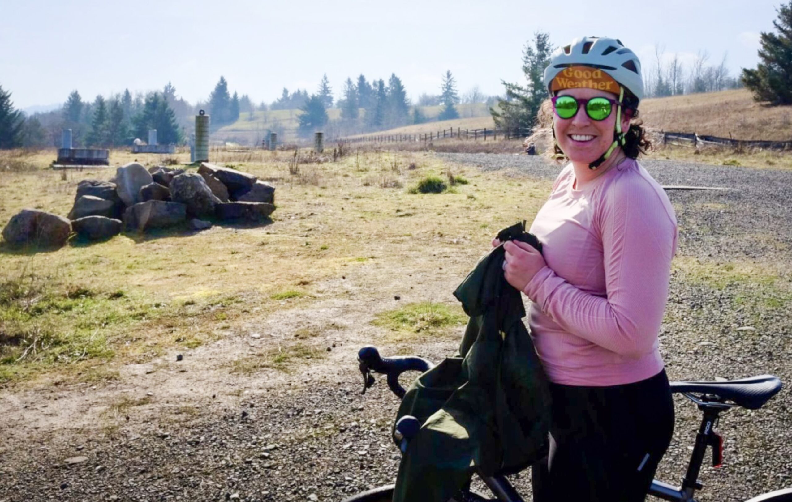
My husband and I recently took advantage of the weather and went for a “fun ride” – that is, a ride without a specific timeline or destination in mind. I’d call it a recreational ride, but the distinction between commuting and recreating is a blurry line and I don’t want to enforce a false dichotomy. Our plan followed our typical formula for a weekend outing: see something neat (the trails at Powell Butte) and eat something tasty (lunch at the Mercado carts in Foster-Powell). The dose of vitamin D from the sunny skies was an added bonus.
During the ride, my husband and I marveled at the many different types of infrastructure we encountered, and the nuances between them.
The Ride
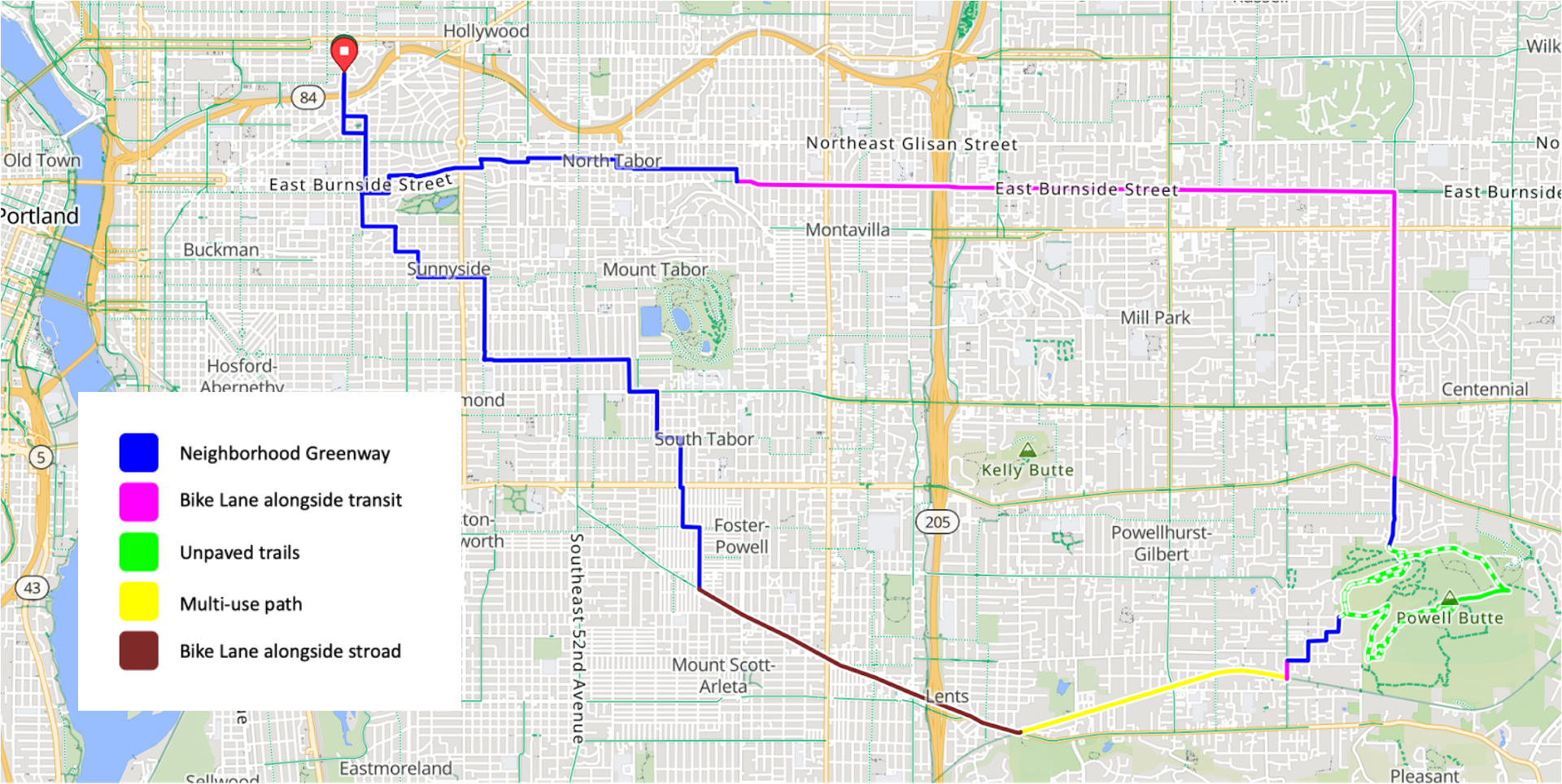
Our ride started in our neighborhood, Sullivan’s Gulch. We zig-zagged on neighborhood greenways through Laurelhurst, North Tabor and Montavilla neighborhoods. In Montavilla, we transitioned from greenways to our second mode, a designated bike lane on East Burnside, where the MAX tracks occupy the center of the road.


Several bike lane miles later, we encountered our third mode: the unpaved trails of Powell Butte. The giant park map at the entrance and easy-to-spot trail markers made it easy to ensure we stayed on trails where bicycles were allowed.
We exited the park and made our way to the fourth mode: the Springwater Trail, a multi-use path set apart from vehicle traffic. After a few miles on the Springwater, we turned onto Foster Street and found our fifth mode: a stroad which has a bike lane frequently interrupted by cones and debris. While on Foster, we stopped at Portland Mercado to enjoy lunch from the food carts there. After leaving Foster, we traced Neighborhood Greenways through Foster-Powell, South Tabor, Richmond, and Sunnyside to make our way back home.
Over lunch, my husband and I discussed the different modes we had encountered that day. His favorite was East Burnside, when we rode in a bike lane alongside auto traffic and the MAX. I was genuinely surprised – we had ridden our gravel bikes so we could enjoy trails, and I expected him to say Powell Butte! He shared that riding alongside the MAX reminded him of riding in Europe, and that the auto traffic on Burnside was a lot more tolerable than, say, Foster.


As I reflected on my own favorite, I was surprised by my own answer – I found riding the Springwater most enjoyable. There was plenty of space to share the path with pedestrians and other cyclists. As we entered the Springwater, I remembered comments from BikePortland readers about encampments along the trail, but I never felt threatened or obstructed by those who live along the path.
Though Powell Butte was a welcome break from pavement, the shared-use trails were crowded with folks eager to get out in the rare February sunshine. I found myself stopping and starting often to yield to hikers. Next time, I’ll plan to ride there on a weeknight… or I’ll just bring my hiking shoes and leave the bike at the park entrance.
For both my husband and I, riding along Foster was the least-favorite part of the route. The bike lane was often blocked by cones, and it wasn’t clear if the cones were placed by PBOT or local businesses. But, Foster redeemed itself in one key way: at several points, the cars around us were caught up in a traffic jam while we had the bike lane completely free for travel.
One my favorite things about moving to Portland has been getting to know the places around me as I fill in my mental map. The breadth of bike infrastructure makes it possible to do this on two wheels. What’s your favorite type of infrastructure to ride on?
— Read previous New to Portland posts here.


Thanks for reading.
BikePortland has served this community with independent community journalism since 2005. We rely on subscriptions from readers like you to survive. Your financial support is vital in keeping this valuable resource alive and well.
Please subscribe today to strengthen and expand our work.
I agree with your assessment of Foster, it kind of sucks to ride on! My biggest beef with it is that the bike lanes are in the door zone, and the number of conflicts from turning cars on the side streets. It used to be 4 lanes but got the road diet, so it’s better than it used to be I suppose. The design also doesn’t appear to preclude making the bike lanes adjacent to the curb and parking/concrete protected.
Hi Erin! Welcome to Portland! I’d love to see you on one of my rides. I lead a monthly chill pace road ride for ladies “Southerly Ladies” and a bunch of other stuff too. More info at bicyclekitty@blogspot.com or feel free to email me. Cheers! Maria
I’ve got a soft spot for biking on Foster, though I am a noted masochist I think. I love whisking by slow traffic, and diagonal streets that used to have streetcars have a special place in my heart. Plus, it’s way better than Sandy (the other choice for diagonal former streetcar streets that are quite wide). I guess if you want to bend the rules on what “diagonal” means though, Burnside also qualifies (since it had the Mount Hood Power Co interurban for a while) – but the parts of Burnside that are really diagonal also are way less enjoyable to bike on (out by 181st).
Anyways, glad you enjoyed the Portland Mercado food carts. The main building got hit with a fire recently (ish), not sure if there are still opportunities to directly contribute to recovery or not, but definitely a place worth supporting!
I can’t say I’ve ever thought about “diagonal streets that used to have streetcars” as a route criteria – hah!
Thanks for the tip on recovery efforts for Mercado. Part of the decision to dine there was to support them following the fire. I was pleased to see a decent lunch crowd forming.
Before the streetcars lines and even white settlement they were Indian trails
https://www.portlandoregon.gov/transportation/article/65571
Sandy, Powell, and Foster were all Indian trails, but Burnside east of 90th is an old railroad right-of-way (it runs at a slight angle northwest to southeast until well after 200th in Gresham). There’s also several abandoned airfields on the east side.
Apologies if I missed the reference in the story, but which street/route did you take to Powell Butte once you turned south off of Burnside?
Hey, Matt! I rode south on 148th to get from Burnside to the Butte. The road has a bike lane, and it’s protected around the intersection with Powell. It becomes a Neighborhood Greenway in the last few blocks before the entrance to the park.
Enjoyed the article and look forward to reading about further journeys.
My favorite East Portland connections:
NE Sacramento between 148th and 162nd, nice tree-lined complete street.
SE 129th between Division & Powell, the little sidewalk connector at the center between 2 cul-de-sacs (part of the 130s bikeway).
The gravel section on NE 157th between Glisan & Burnside, where the DC8 crashed. We used to do a ride called The Good, The Bad, And The Ugly, about all the worst gravel and potholed streets in East Portland.
NEd Flanders at 108th. On SE 108th there is a weird connector from the 4M to Division alongside the Cherry Park Elementary School.
SE Clay Street from 106th to 107th, which I always found very odd but comforting.
There’s a narrow 3-foot walk path from SE Sherman to 132nd in between a fence and a wall, an odd piece of PBOT public right-of-way.
The bollards from SE Circle Ave to SE Powell Butte Pkwy
My favorite type of Portland riding is via the greenways. Yes, they’re slow, often not very direct, easy to get lost on, sometimes lead you to a place you don’t want to be. But they’re mostly fairly traffic free, often have diverters or other bicycle-friendly infrastructure, and often have way-finding. They are a way to get around without having to deal with as much car traffic, and are generally safer than the bike lanes on main roads. They’re not the fastest way to get somewhere, but they’re often the most pleasant.
I wished I’d known years ago, but the Ridewith GPS heatmap overlay will usually send you down the best routes for lowest stress/safest passage throughout town. Or there’s a Strava version….good luck out there.
“I never felt threatened or obstructed by those who live along the path.”
Then you were lucky. I’ve encountered many scary dudes there.
One day, it’s fine. As little as a few hours later, maybe not.
There’s something about MUPs. When I have a bad time on city streets or country roads, it’s usually my fault. On an MUP, it’s someone else, and often catastrophic, e.g. getting struck at a crossing or run off the road by someone in a car where they have no business driving. It’s lovely that people feel safe on off-street paths but my experience just can’t validate that.
Yes, I agree that if they were to ride the Spring water and 205 bike path more, they would definitely feel threatened. I ride with a budy because i’ve been stopped several times and harassed. We both carry appropriate measures now. Please ride from Johnson creek to Marine drive on the 205 bike path and then tell me what you think, good luck!
I, too, have experienced few problems riding the Springwater Corridor Trail. I’ve ridden it from its start near OMSI clear out to Boring.
Portland seems to have taken steps to clear out the homeless alongside the trail. Last year when riding the trail, I encountered no homeless camps; the year before, I encountered several. However, at no time did I feel unsafe.
What Portland hasn’t done, however, is clean up the trail of the litter left behind by the homeless camps. The trail is much cleaner when you get to the Gresham city limit and beyond, which makes me wonder how a city smaller in size to Portland can do a better job of keeping the trail clean.
Go to Beaverton it’s completely different
Agree that the vibe on the Springwater is very agreeable lately.
The vibe on the 205 path however, is less so.