(Main image: Google Maps)
If we’ve been writing more than usual lately about the county to Portland’s west, it’s because they’ve got a lot of things going.
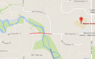
As the Oregonian reported Monday, the county is seeking Metro grant funding to help build a $1.5 million, 550-foot bridge across Beaverton Creek in Aloha.
The proposed bridge would both have big benefits to its immediate surroundings and fit into a rapidly improving bike network in the area. Here’s the Oregonian’s Dana Tims on the hyperlocal benefits:
A new bike and pedestrian bridge spanning Beaverton Creek could create a safe, direct new route for children in more than 900 houses southwest of the creek to Beaver Acres Elementary School.
Planners say the proposed bridge would cut the distance to school for many of those students from 1.5 miles to less than one-half mile. It would also create access to two MAX light rail stations for 2,000 residents living southwest of Beaverton Creek.
In addition, it would also provide access to five miles of trails at nearby Tualatin Hills Nature Park without having to walk along Southwest 170th Avenue, which whirs with fast-moving traffic, but has no sidewalks.
“This project really jumped off the map,” said Steve Szigethy, the county’s principal transportation planner. “It bridges a huge divide.”
Advertisement
On the larger scale, this project would create a new side-street connection between the 185th Avenue bike lane that (as we reported last week) will hopefully be improved across Tualatin Valley Highway and the proposed protected and buffered bike lanes on 170th Avenue and Merlo Road that (as we reported the week before) connects to the area surrounding Nike’s campus.
As we reported in November, road widenings in the immediate Nike area may also include protected bike lanes.
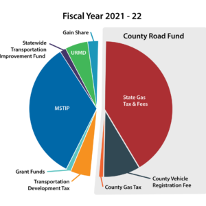
The “Nature in Neighborhoods” grant program that would put up $461,700 of the proposed bridge’s cost is paid for by a regional property tax levy approved by voters in 2013. It’s already been used to help build several bike-related projects, mostly trails with nature and wildlife components, around the metro area.
This project is among more than $4 million of applications competing for $2.5 million from the Metro grant program this year.
Washington County’s leadership on biking issues starts at the top with Commissioner Dick Schouten (whose district covers many of these streets) and includes Land Use and Transportation Director Andrew Singleakis and Pedestrian and Bicycle Coordinator Shelley Oylear as well as Szigethy. It’s exciting to see the county making so much progress.
The county has a long way to go and won’t truly escape its auto-dependent legacy until it readjusts its core priorities. But its cities are also undergoing a fairly clear cultural shift toward low-car life. If the county and its cities keep feeding that trend with better streets, the payoff could be spectacular.


Thanks for reading.
BikePortland has served this community with independent community journalism since 2005. We rely on subscriptions from readers like you to survive. Your financial support is vital in keeping this valuable resource alive and well.
Please subscribe today to strengthen and expand our work.
This is a great idea. A quick look at the map shows how much good sense it makes. 170th in that area is no fun at all, even in a car. Speeds are too high for the narrow street, and there’s no shoulder at all. I like the idea of being able to get through to 185th easily, too.
> “It bridges a huge divide.”
Literally.
It’s a cool project. Props to Steve Szigethy and other staff at the County for working on this.
excellent!
ooooo!
Not exactly sure from looking at the map, but I think also, that the bridge to be built, in connecting neighborhoods to the south by way of Augusta, will also allow an easier connection to north south 178 and 177th, and then to Alexander.
Michael, and bikeportland, thanks for writing up a story on this most recent Washington County bit of bike pedestrian infrastructure. I saw the story on the Oregonian’s site last night, and was excited.
The O quoted a neighbor whose property adjoins the easement for the bridge, and who, not noticing many people presently walking in the area, has doubts about the bridge seeing much use. I think thoughts such as that expressed by the neighbor, are important to confront head on, and by actually getting out there and using it when it’s built, demonstrate that the truth is to the contrary.
Away from the intense traffic of 170th, the area through which Augusta and Pheasant pass through, is a nice, quiet, low car ride. So should the neighborhood to the south be, and I think once the bridge is built, allowing travel by bike and car to be more practical and enjoyable, there may well be quite an increase in walking and biking in this area.
The residents of unincorporated Washington County add up to make the second biggest city (if it magically became one city). Raleigh Hills, Garden Home, West Slope, Metzger, and West Haven-Sylvan need to incorporate into one new city, imo.
Paths like this are an excellent way to improve connectivity through byzantine neighborhood streets for non-motorized travelers. This proposed route would provide a nice, quiet alternative to Baseline or TV Hwy for traveling between the Nature Park/MAX stop area and 185th.
It is interesting that this improved trail/bridge is being contemplated by “Washington County”. There are several paved paths and bridges that were recently completed near my Bethany neighborhood, which provide connections to shopping centers, parks, and neighboring neighborhoods—but they were installed by Tualatin Hills Parks & Rec., and therefore are technically parks which are closed after dark. I wish there were some way to get the County to work with Parks and come up with a way that all such useful routes could remain open for transportation at all hours. Not that Parks trails are physically barricaded after closing time, but anyone caught on them by a grumpy Ranger is subject to fines and exclusion. Not yet having the high usage rate of a path such as the Springwater, it would be a tough sell to convince anyone that they were a vital transportation corridor, but especially on dark, rainy, Winter afternoons, it would be nice to have a non-motorized alternative route available that was 100% legal to use.
This trail follows an unbuilt public right-of-way which means it is public property. It is a transportation issue. SW Trails in SW pdx has often worked with issues like this.
I use Tualatin Hills Parks and Rec paths after dark nearly every day in the winter. Never had anyone say anything to me. Non-issue or are they enforcing the after dark park closure on bike commuters in some parks?
I don’t actually think there is much enforcement of closures; I also use these trails after dark for commutes home in the winter. I would bet someone would have to complain for Parks to send anyone out to enforce anything, but the fact remains that for that last leg of my trip home on a dark evening, I’m breaking the law and just not getting caught.
“… This proposed route would provide a nice, quiet alternative to Baseline or TV Hwy for traveling between the Nature Park/MAX stop area and 185th. …” bic
If people are prepared for a kind of slow, leisurely, recreational type ride, the neighborhood streets the new bridge and path will connect, may serve their transportation needs as route between TV Hwy, Baseline, and 185th.
I doubt it’ll be up to meeting the needs provided by a full fledged bike commute route. Not sure about the park trails over in Bethany, but the THPRD nature park trails really should not be thought of and used as a serious bike transportation route. Through the park, dawn to dusk hours are when the park and its trails are open to use. Safety issues, which the park district obliges park rangers to address according to district regulations.
Near or adjoining 170th is where a full fledged connecting bike commuter path should be. That infrastructure there could provide a comparatively fast, straight through connecting route between 170th and Baseline, and points in between.
I don’t know what a route has to look like to be “serious”, but when I can take my kids with me to two shopping centers from my house without having to ride on Bethany, West Union, or Laidlaw (Bethany isn’t bad, but West Union and Laidlaw can be scary on a cargo bike with kids), or make left turns across busy streets, I “seriously” consider using them to do so. I’m guessing that by “serious”, you mean “high-speed, high-volume”. Even routes where the understanding is that the pace is slow can be very important links in any kind of route, whether poking along to school, or just cutting over from 185th to Millikan Way on the way to work without being bothered by TV highway traffic. A route should be usable to get to any destination, but yes, all users have to be aware of prudent speeds and behavior to avoid safety problems.
It’s a disappointing (but understandable) that Nike didn’t allow the power line trails through their campus. It’s slightly ironic that a company who makes athletic apparel, has a people who commute from the “North of 26” area, and has a bike share at the Beaverton Creek MAX stop wouldn’t try to promote biking a little more.
It’s a bit of a mystery why Nike retains the wooded parcel of lane to the south of the campus for private use only. Though Nike has title to the land, and the company apparently so far, hasn’t decided to knock down the stand of tall, many years old conifers growing on the land, to pave it over with asphalt, concrete and buildings. There’s that to be grateful for. And, the company is generally considered to be a good employer.
Making the Westside Trail connection with a bike from where it ends north of Merlo, to where it picks up just south of the light rail station, isn’t an overly difficult situation as things are right now. From the light rail station, trail users can ride through the nature park for a short distance, where they’ll find a side trail going off to the east, which will take them directly to where the Westside trail continues on.
“…I’m guessing that by “serious”, you mean “high-speed, high-volume”. …” bic
Basically. Bike lanes and multi-use paths that could support biking at both fast and slow speeds, and that would be routes that could be used by possibly high numbers of people riding.
Transportation and commuter routes for bikes, generally shouldn’t be using park land for that purpose. THPRD has had problems with some people biking on the parks bikes allowed asphalt paths, my guess, about those I’ve personally observed, is that they’re people off work, just want to get home, etc, etc.
The park visitor center has over the years, had reports about this kind of misuse. For this particular park, the word I heard some time back, is that to provide some of the people commuting, a route near to but other than riding through the park, a connecting bike trail next to the north border of the park from the Merlo light rail stop to the Westside trail, just to the east of the park, will be built. For a short distance, it’ll parallel the light rail line. Work may have already started on this, but I’m not sure. In fall, some brush was taken down, but it’s still lying there, and no further work has been done yet.
I’ve been stopped and warned twice by park patrol after dark and it is a bit unsettling. The first time (on foot) I thought I was going to get mugged and the second time (they were driving a SUV on Fanno Creek TraiI) I thought I had a drunk driver chasing me. With that, I have spoken with the main office at THPRD about it (2013) and they said the after dark rule was not enforced on commuter routes.
“…I have spoken with the main office at THPRD about it (2013) and they said the after dark rule was not enforced on commuter routes.” Brian Engelen
Brian, do you recall whether the THPRD person you spoke with, mention specifically about which park trails the district considered to be on commuter routes, and that could be used as commute routes for bike, including after dark?
I’ve never asked, though as I mentioned earlier, one likely reason for the restriction between dusk and dawn, particularly through heavily wooded areas, is the security, or personal safety issue.
Except for it being a Washington County story, and having to do with nature park land, off topic, but I wanted to mention today’s story in the Oregonian, about the long term, eventually successful effort to add new land for nature park in the Orenco area.
http://www.oregonlive.com/hillsboro/index.ssf/2015/01/the_orenco_woods_saga_how_the.html
A bunch of people had to work very hard to keep this land from being paved over, and eventual success ultimately was due in no small part to luck. Metro was involved, too, cash in hand when the circumstances allowed.
pathetic waste of public funds / the bicycle enthusiasts really need to ride their bikes as they can – and zip it.
Washington County is making believe that it doesn’t have to deal with clogged roads/ lack of adequate public transportation (you know, trains and buses) , sidewalks, street lights, safe and enforced crosswalks, etc.,
at this point, it is obvious that there is a massive conflict of interest going on here –
1.5 million for a short bridge???? trumps how many other projects???
benefiting how many off-ignored members of the community????
are you kidding????
selective boondoggle express.
“….1.5 million for a short bridge???? …” constance kosuda
I agree that 1.5 million is a lot of money, though the bridge, at 550′ feet long, isn’t what many people would consider to be short. As to how many people will use the bridge, that remains to be seen. I have an idea the route this bridge will provide for walking and biking, could become very popular, and that with its construction, many people may come to realize its just what their neighborhood needed to have the physical activity they would like to enjoy, become more practical in their neighborhood.
The way I look at recreational transportation functional infrastructure like this bridge would be, is that it helps to counter, and reverse, some of the extraordinary reduction of area livability that increased motor vehicle use, and roads expanded to accommodate that use, have resulted in.
So, that 1.5 million bucks has a lot more potential to improve and help sustain livability of this area than say for example, widening 170th from its country simple two lanes, to a four or five lane thoroughfare would. This bridge will be much more than a bridge by which to get over the crick, on foot and bikes. It’s something that’s going to open up active life opportunities that questionable planning and excessive motor vehicle use have crippled for many years.
Why not use the money for something more useful? Like sidewalks. What about the trees that will be cut down? The deer and other wildlife will impacted by this? It’s their home and we are go to destroy a large portion of it for a bridge? So very sad. I really hope they can find a better way to spend this money.
wsbob – bike to your heart’s content / walk around /dash in and out of traffic / the bottom line is that this “bridge” is designed by and for a very select few / it is NOT a high priority item for the suffering masses of Wash Co. residents / who need public transportation / sidewalks / street lights, and direct access to work, schools, and all these frikkin parks which are not accessible in any meaningful fashion, unless one drives, or skips long distances.
please consider seniors / the disabled / children who need supervision / and the common folk / not the privileged and entitled few who seem to think that they always get to jump to the front of the line.
lots of money to benefit the very few, as per usual.
A couple more things. The area on 178th this is going on is a one lane street with no street lights. I certainly wouldn’t send my kid down that street in the dark to cross a bridge in the dark alone so they could get to school faster. Just my opinion.