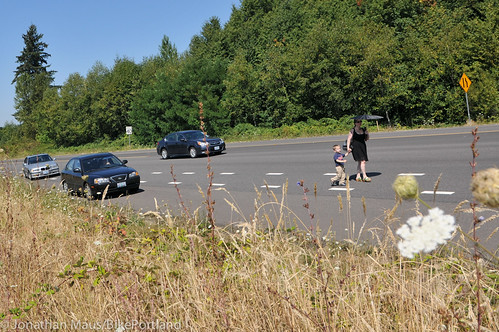
on SW Barnes near Cedar Hills Blvd.
(Photo by J. Maus/BikePortland)
Well, this is more or less the question that any road user dreams of being asked.
The county to Portland’s west has $2 million to spend on street safety this year inside its Urban Road Maintenance District (part of the county’s urban areas outside city limits) and is looking for comments on where and how to spend it.
The county already has a working list of 22 projects, all categorized as “pedestrian path.” Most of the project descriptions end with the phrase “so pedestrians do not have to walk in the travel lane with vehicles or alongside the road in the grass and mud.”
Enough said.
Advertisement

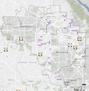
Maintenance District and 22 proposed projects,
marked here in purple.
(Image via the county’s interactive map)
What other trouble spots should be on the county’s list? Are there any small, cheap fixes that might squeeze into gaps in the budget? There’s a good deal more than $2 million in work identified on the current list, so the county is likely to be parceling out these projects across years.
As the Oregonian noted last week, this work is funded by a property tax on local owners in the area. They pay a little less than 25 cents per $1,000 in taxable home value.
If you’ve got comments or projects to nominate, follow these instructions by Feb. 13.
Correction 1/13: Because of an error in the Oregonian article, a previous version of this post inaccurately described the number of project ideas Washington County wants to gather.


Thanks for reading.
BikePortland has served this community with independent community journalism since 2005. We rely on subscriptions from readers like you to survive. Your financial support is vital in keeping this valuable resource alive and well.
Please subscribe today to strengthen and expand our work.
SW Leahy Road and the West Haven-Sylvan neighborhood needs one for the all-new grocery store opening this summer on the corner of SW 90th Ave and SW Leahy Road (right by two big schools and a hospital).
OMG, scary photo. I changed my bike commute to avoid that stretch – I can’t imagine walking there, especially with a young man in tow.
Seriously, there are cars driving 50+ there, and cutting across the long bike lane transition zone whenever they feel like it.
The picture is from what was my daily commute for six years. I forgot how bad it was, but had to take that route recently when the wind storm hit, and the Max was broken.
Every day I’d have to contend with drivers who couldn’t bear to slow down and just had to get in the right turn lane in front of me rather than behind me, even if it meant making everything more dangerous for me and the driver.
Below this intersection, on a steep incline, is another right turn lane where the bike lane just disappears, and then reappears to the left, as if people on bikes are expected to do a little quantum tunneling to stay in their assigned infrastructure.
I’d like to say that a two-part test should be applied to all bike infrastructure: that the designer has to ride what they created for a month after it’s put in; and that they would be willing to have their eight-year-old child do the same for a week. I’d like to say we should have this test, but the fact is that they’d be so frightened that they’d rather just never put in the bike lane to begin with.
“I’d like to say that a two-part test should be applied to all bike infrastructure: that the designer has to ride what they created for a month after it’s put in; and that they would be willing to have their eight-year-old child do the same for a week. I’d like to say we should have this test, but the fact is that they’d be so frightened that they’d rather just never put in the bike lane to begin with.”
Brilliant – well put.
The intersection in the photo is poorly designed in a number of ways. First, as PeeJay noted, to the left of the area shown in the photo, the street drops off steeply, so there’s no line of sight to oncoming traffic. There is a right turn arrow light from Barnes to southbound Cedar Hills Blvd., but once you’re up to the corner, the light is behind you, so it’s useless. Traffic flies through there far too fast, and to make it more fun, there are ramps on and off Hwy. 26 just around the corner. For some reason I’ll never understand, there’s a light for one of the side streets, but no light for the off-ramp from 26 (eastbound), so people who want to turn left (north) onto Cedar Hills Blvd. from the off-ramp far too frequently cause close calls or bully their way through traffic stopped at the (far less used) cross-street. It’s a mess.
Here in America this is the best we can do?
I’m sure this isn’t what they are asking for, but I’d start by dropping the speed on nearly all of the 45mph roads to 35mph.
35 mph (actually 40+) does not offer much protection. at least at 50+ death is more likely to be quick.
At 45 the usual speed approaches 55, which means they have a 35mph overtake on me. At 35, the usual speed of 45 means they have a 25mph overtake. A nearly 30% drop in overtaking speed is not inconsequential.
I’d take that on Barbur over the narrow bridges if I could get it – it’s easy to run high 20’s going down there and a less than 20mph overtake would sure make those more comfortable.
Photo-radar enforced would be even better yet. 🙂
45 mph, risk of death to pedestrian 100%; 35 mph, risk of death to pedestrian 90% (source, wramborg graph, OECD).
$2M isn’t much to work with. Photo enforcement vehicles and staff?
There are many drivers who DO mostly comply with 35mph speed limits (I’d hazard a guess that compliance is better than in a 45mph speed zone) and those slower drivers should slow others around them. Even without additional enforcement.
Too many to count so I’m going to continue beating what seems to be a dead horse of asking for the bike lane back that they screwed up and removed between 91st and 95th on Cornell going up the hill when they last repaved. Notified the county about this many times, every time they say they’ll fix it and nothing ever happens >:(
The downhill lane looks to be a sub-standard as well. Is it even technically wide enough to be bike lane?
Short answer? All of them.
20 MPH max speed limit on public roads, 10 mph max on residential streets.
My other comment is stuck in moderation. It basically says that Washington County does not install mid-block crosswalks, per policy. That policy is ludicrous, considering the shortage of intersections on many roads in WashCo.