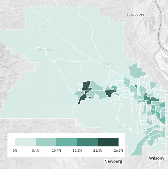
(Map: Census Reporter – click image for interactive version)
Central Forest Grove, Hillsboro and Beaverton are now as car-lite as many parts of east-central Portland.
More than 15 years after the MAX Blue Line tunneled westward into Washington County, and as the county prepares for investments in an array of bike infrastructure including a neighborhood greenway network, several protected bike lanes and its ever-growing network of multi-use paths, it’s becoming commonplace to live without a car in the county’s central cities.
“If you live in Orenco, it’s right on a transit line. It’s a very dense, walkable neighborhood where you have your amenities right there.”
— Jenny Cadigan, Westside Transportation Alliance
One possible factor: rising prices in central Portland may have pushed more low-income households into the suburbs. The lower your income, the less likely you are to own a car and the likelier you are to walk, bike or ride public transit for transportation.
However, Washington County’s poverty rate didn’t rise last year. It fell. It’s only added one percentage point to its poverty rate (from 9.9 to 10.9 percent) in the last five. So the shift might be that carlessess is becoming more viable for the poorest households. Also, non-poor people might be spending their limited income on other priorities.
“In my opinion, it’s whether you can get to your job easily without a car,” said Jenny Cadigan, executive director of the Westside Transportation Alliance. “If you live in Orenco, it’s right on a transit line. It’s a very dense, walkable neighborhood where you have your amenities right there.”
Whatever the reason, Washington County’s zero-car population is almost certainly rising. Though margins of error mean that we should give or take a percentage point on all these figures, the county’s estimated rate of zero-car households leapt by an entire percentage point from 2012 to 2013 and is up a point and a half since the 2008-2010 census surveys. That’d be the fastest increase in the metro area.
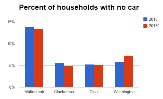
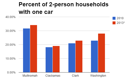
(Charts: BikePortland)
That’s not all. The sort of households BikePortland likes to call “low-car” seem to be rising fast in the county, too:
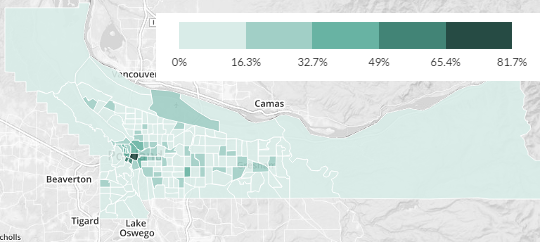
Where are these changes taking place? That’s hard to tell with precision, but the map at the top of this post suggests that the shift is centered around the three swatches of the county that were built before the automotive age and retain their historic street grids.
On the north side of central Forest Grove, the Census Bureau estimates that 27 percent of households live without cars, give or take 8 percentage points.
Washington County’s shift toward low-car life doesn’t seem to be related to changes in the number of people per household. There have been no clear changes to household size since at least 2007.
“My first instinct is that the county is attracting younger people who are choosing not to own cars,” Cadigan speculated. “I don’t know who Intel and Nike are hiring and attracting. People are choosing to live closer to their jobs.”
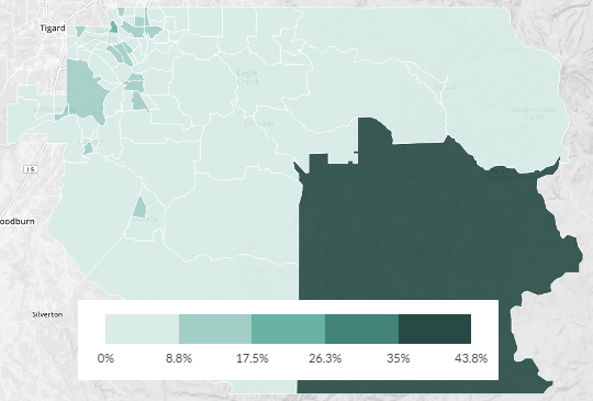
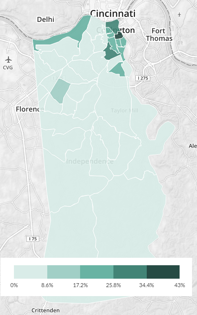
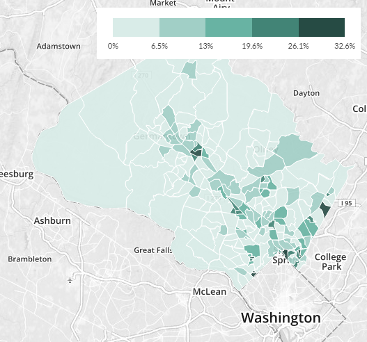
How does Washington County compare to other nearby areas? It’s not wildly different. Here are some more maps, all of them published Sunday on the wonderful CensusReporter.org and based on 2009-2013 census data released this month. Note that the color scales are different on each map; on Multnomah County’s, for example, census tracts of the second-lightest color have zero-car rates comparable to tracts of the darkest color in other counties.
Advertisement
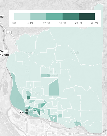
The trend here — zero-car rates of about 25 percent of households in the pre-car gridded parts of inner-ring suburbs — isn’t unusual nationally. You can see it in Kenton County, Kentucky, outside of Cincinnati:
And in Clark County, Indiana, outside of Louisville:
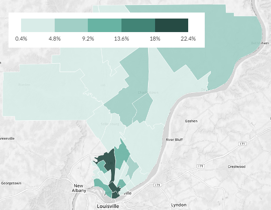
One thing different in the above two counties is that they don’t have the further-out hubs of low-car life that are visible in Hillsboro and Forest Grove. But Montgomery County, Maryland, which is even more prosperous and job-rich than Washington County, looks more familiar. As in Washington County, you can see the neighborhoods where commuter rail lines have connected to (and allowed further development of) small historic downtowns:
There’s a possible lesson in these maps for those of us interested in reducing suburban dependence on cars. Advocates spend a lot of energy trying to expand bike, transit and walking infrastructure to new parts of suburbs, and that’s an admirable goal. But even in suburbs, low-car and car-free life seems to already be totally plausible in neighborhoods that have two things: densely connected street grids and frequent public transit into the central city. Maybe we should spend as much effort increasing the population capacity of these functioning neighborhoods — including the ability of low-income households to live there — as we spend fighting to improve sprawling ones.
You might also enjoy this recent comment of the week about making Beaverton the country’s #1 bicycling suburb.

")

")
Thanks for reading.
BikePortland has served this community with independent community journalism since 2005. We rely on subscriptions from readers like you to survive. Your financial support is vital in keeping this valuable resource alive and well.
Please subscribe today to strengthen and expand our work.
I wouldn’t necessarily make the assumption that “poorer” people are being pushed out to Washington County. It may be more that common sense is kicking in. Out here you can get more house for less cash. The map also seems to line up very closely with the MAX corridor.
As many people have pointed out on this site, with Intel, Nike, etc all situated west of PDX, people are probably smartening up and instead of spending an hour plus on MAX or driving, they are choosing to live closer to their job.
While my wife and I are not a zero car household, I have not driven to work since we purchased our home in Hillsboro in February. I bike, MAX, run or some subset of two of those 3 options.
Seriously, why pay $300-500K for 1,000-1,2000 square feet, when we paid under $200K for 1,600.
As I’ve stated in various other comments, I’m a mile from Orenco, less than a mile from Hawthorn Farms MAX and about 2 miles from Imbrie Drive. Everything I need is pretty darn close.
Have to agree with this – my GF and I (car free for 25 years) moved out of downtown exactly 2 years ago (after living within a mile of PSU for over 20 years) because we got tired of the limited space / rising costs.
Having a garage for storage and to work on my trikes/bikes has been a godsend, and I’m not sure I can go back 🙂 (also, even with a monthly bus pass for her that we didn’t have to get before and the expense of the garage we’ve saved about $5000 in the last 2 years. That’s nice at any income level)
The key opportunity for this data and the evolving discussion on transportation for these areas is:
1) focus on the ‘car-lite’ households, since this is much more attainable for most than full car-freeness [the era of the ‘norm’ having >1 car per person in a household is over here and in many regions…we are returning to how things were in my childhood and before…1 car being shared and mass transit etc. supporting other trips]; and
2) remember that only a quarter of the daily trips each household generates is “commute” related and thus it is easier to effect the 75% of trips that revolve around more local destinations, trip chaining and less time critical…even though the Feds’ (and METRO’s) focus traditionally has been the commute (or peak) trip.
Todd, I’m the last one to disagree with the need to focus on “car-lite” as well as zero-car situations, but look at those maps! If 25 percent of households in Hough and Forest Grove and downtown Hillsboro are living without cars, we’re not talking about a fringe here. Presumably it’s mostly a combination of college students + social-services clients + other lowish-income young folks and seniors. But that’s adding up to a pretty impressive chunk of the population in those areas.
Michael, are the heat maps actually indicating ‘car-lite’ households? Otherwise they don’t add up the the bar graphs for no car households.
They’re for zero-car housholds. In what way do they not add up?
Sorry, I was misreading: the bar graphs are for the county as a whole. I guess I’m just really surprised by the heat maps.
Michael, no disagreement about the Hough’s, Arnada’s etc.of the world having 25% car free…my point is that Vancouver has 63 other neighbourhoods…and if we can help them shift into 1 car households more the better. (Ask anyone who knows me…I would welcome more car-free households up here.)
Thanks for including the Clark map (and giving us some BP love up here)…the strong car-free numbers in our downtown neighbourhoods really shows us why City transportation staff should not have punted on the Columbia bike lanes (again, for the 3x in 15 years). Their work has sowed the fields…so now it is time to reap the rewards and install the bike lanes (or even separated uphill bike lanes) versus the bike sharrows done this summer. (I have not heard any update on how it will be fixed in 2015 yet.)
Forest Grove has three census tracts with >20% zero car households. Two have median household income $24-27K (332 and 325.01), which is certainly low; one is $46K (331.02) but is only 249 people.
I’m not familiar with Forest Grove. How does a zero-car lifestyle look there? Are there walkable and bikeable neighborhoods with grocery stores, schools for the kids, workplaces, etc within easy reach? Safe roads to ride and decent bike lanes? Good transit connections to Portland and neighboring towns? Or, are the zero-car households there more likely to be people who can’t afford a car, living in retirement homes, etc?
Also students, I think.
(And FWIW, that’s 249 zero-car households rather than 249 people … but yeah, small.)
Yes, you are right.
Interestingly, the number of zero car households in these tracts is not very different from the number of households with income <$15K/yr . . .
What I am wondering is, if the "zero-car lifestyle" that we see in the numbers is what I'll call the "good" version (households willingly adopting a foot/bike/transit lifestyle) or what I'll call the "bad" version (households who are too poor to afford a car) or some "other" version (an elder in a retirement home, etc). You point out this uncertainty in your story.
I guess that if transit etc has improved so that a low-income household can survive by spending their limited money on things other than a car, that is sort of "good", but I hope we're not just looking at a thin silver lining on the ugly trend of growing income inequality.
Yeah. The “sort of good” scenario you describe, which I think is fairly common, is the main reason I’m personally interested in bike advocacy.
Lots of Pacific University students, senior housing, free local bus service, old style street grid with low car volumes, level terrain.
Central Forest Grove – north of Pacific has A LOT of retirement housing. Jennings McCall is huge – and that’s just one of many.
Interesting that no car households actually went down between 2010-2013 in Multnomah. Though I’m sure it’s not statistically significant.
That because most people are not car-free by choice, but rather economic necessity. As an improving economy raises incomes the rate of vehicle ownership is sure to rise, along with the ownership rates of toaster overs, lawn mowers, and most other forms of personal property.
If you get more people using light rail you need better light rail service. The Blue Line is overcrowded and too infrequent during rush hour, in both directions. Tend away from cars, especially in Washington County, is encouraging, but that means there is a need for light rail expansion. I reverse commute by bike and Max from SE PDX to Hillsboro and it is so crowded I now ride a Brompton.
The Blue Line is overcrowded and too infrequent during rush hour, in both directions. Trend away from cars, especially in Washington County, is encouraging, but that means there is a need for light rail expansion. I reverse commute by bike and Max from SE PDX to Hillsboro and it is so crowded On Max I now ride a Brompton. Cycling over there is terrifying BTW.
An overhaul of crash corner in Raleigh Hills could lead to a rise in more pedestrian and bike traffic near that Parr Lumber.
Just from my observations, biking numbers are up on the Westside. In my time of commuting to Hillsboro from Portland, I’ve seen the number of cyclists commuting to work increase big time, at least along Baseline Road. That’s encouraging.
Talking with several co-workers, they’ve stated they too would use their bike to commute to work, but roads such as 185th, Cornell, Cornelius Pass, Baseline and TV Hwy scare them to death and they don;t want to take the chance. Hopefully investment in the local biking infrastructure will lessen the worry of these folks.
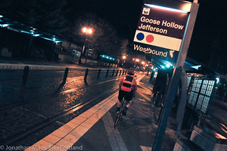
I also agree with Alison regarding the MAX. More and more folks are choosing to ride into NW PDX and catch the MAX to the Westside (and vice versa, getting off at Goose Hollow in the evening). It’s packed in the morning, worse in the evening and 3X more bikes than hooks on any given rush hour Blue Line route makes it that much more uncomfortable for passengers. I know it would take a compete reconfiguration of the MAX system (lengthening platforms, longer trains, etc.), but it would be great if Trimet had smaller bike-only MAX cars (like those in Boston and elsewhere) that would separate cyclists from the average MAX commuter, making it safer and more comfortable for everyone involved.
Further, I think more folks would use the MAX if the Westside had a quicker, breeze-like morning/evening line that only operated from Beaverton TC to Hatfield (and vice versa) and made stops at the following stations: Millikan, 158th, 185th (PCC Willow Creek), 231st, Hillsboro Airport, 7th and Washington (Tuality/Pacific University) and Hatfield.
Just my two cents.
What are the suitable routes for bike commuting from Hillsboro to Portland? Either routes that are good today, or that could be good with some realistic bike infrastructure improvements.
I don’t know the area (Hillsboro) well. The only road I’ve even ridden in that direction is Cornell, which I think is an uncomfortable, overly hilly, and frankly dangerous (during rush hour) road to ride on. I ride it on weekends in spandex; I rode it once on my commute bike during the afternoon rush hour, to go to a meeting in Forest Heights, and said never again.
An ODOT highway TV Highway becomes SW Canyon Road and it needs an overhaul. SW Canyon Road east of SW 87th Ave does not need 4 automobile lanes. The BTA has called for an overhaul of TV Highway / Canyon. I’ve rode on Canyon this year and it is not that pleasant.
It depends on where you are going in Hillsboro. Yes, Cornell can suck, but at least is has designated bike lanes going West to East and vice versa. Evergreen is better than Cornell, TV Hwy I would not recommend, though it too has bike lanes.
I ride Baseline Road, which is really less of a road and more of a highway. And, the chunk of Baseline approaching Cornelius Pass is most likely only going to get worse with the new Walmart going in.
To get to the Westside from Portland, from Goose Hollow, you can either ride up through Washington Park to the zoo, or take the MAX to the Washington Park/zoo stop.
Coming out of the zoo, take a right onto SW Canyon Court and take it to the pedestrian trail that runs along Hwy 26. This trail will end around SW 97th. I normally get onto Wilshire, then onto Park Way, dropping down onto Cedar Hills (limited bike lane use as of Walker), then taking a right onto SW Jenkins, which becomes Baseline, which becomes Main St into downtown Hillsboro.
It is getting easier to bike around on the Westside. But, with the amount of people driving to/from the Westside (and these numbers continue to grow), it would be nice if these bike lanes included buffer lanes for added safety.
As we can see from the Regional Equity Atlas, the census tracts with the highest percentages of zero-car households tend to be those with the lowest median incomes (https://gis.oregonmetro.gov/equityAtlas/Default.htm?scene=968d73ff) and highest levels of poverty
(http://censusreporter.org/data/map/?table=B17001&geo_ids=05000US41067,140|05000US41067&primary_geo_id=05000US41067). A few of these areas include Hillsboro, Forest Grove, and Beaverton.
For our family of 7, going carfree in Hillsboro was a logical choice after living here for one year and finding out how easy it is to get around on foot/bike/Max. Four years later we’re loving carfree lifestyle more than ever for reasons of physical fitness, mental health, cost savings, fun, stress reduction, time outdoors, and freedom from the discomforts of sitting in a car. http://www.facebook.com/CarfreeFamily