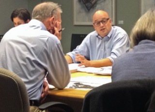
committee members on the Our Street
funding effort.
(Photo J. Maus/BikePortland)
This morning in a conference room in the Portland Building, Bureau of Transportation staff laid out how they intend to spend $173.8 million in new revenue they hope to collect from residents and businesses in the first six years of the “Our Streets” funding plan.
While 42% of all the new revenue go toward paving (about $75 million), bike-specific investments are also on the list. A new carfree bridge over I-405 at NW Flanders Street and a protected bike lane on NE Broadway from 24th to the Broadway Bridge make up a list of about $7 million in projects that would dramatically improve biking conditions.
PBOT called this meeting to share an update on the funding plan to their various advisory committees. Among the 12 people in attendance at the meeting, six were city staff and the others were representatives from the City’s freight, bicycle, and pedestrian advisory committees. Members of the City’s Transportation Needs Funding Advisory Committee and Business Workgroup — both put together specifically to address the Our Streets plan — were also at the meeting.
It’s the start of a big day for the Our Streets effort, with City Council set to discuss the plan at their work session in City Hall from 3:00 to 5:00 pm today (you can watch it live online here).
Advertisement
At this morning’s meeting PBOT offered unprecedented specifics as to how they plan to spend new revenue.
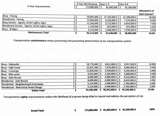
Figuring in administrative costs and non-compliance (known by the unfortunate term “leakage”), the City expects to collect a total of $173.8 million over the programs first six years (based on an annual estimate of $40 million in new revenue split between an income tax and a flat fee on businesses). Of those funds, PBOT’s latest draft project list shows that 53% — or $92 million — would go to “maintenance” projects and 47% — or $81.7 million — would go to “safety” projects.
This 53/47 split would not meet the demands of a coalition of advcocacy groups that includes the Bicycle Transportation Alliance, Oregon Walks, Coalition for a Livable Future, and others, who say anything less than half the funds going to safety is “insufficient.”
Here are the three and six-year spending category breakdowns shared at the meeting (click to enlarge):
While improvements to cycling conditions would arguably come with nearly every one of those categories, the most eye-catching, bike-specific projects are under the “Protected Bike Lanes/Routes” heading. PBOT would spend $6.9 million in this category in the programs first six years (4 percent of the total Our Streets revenue).
If the Our Streets plan becomes reality, here are the two bike-specific projects PBOT would like to spend the money on in years one through three:
- PBL 1 – Central City; fill out the projected bike lane netwwork identified in the Multi-Modal project. Cost estimate: $3 million
- PBL 2 – 9th Avenue; perform a Type, Size and Location study for a bridge across the Banfield [I-84]. Cost estimate $300,000
And in years four through six:
- PBL 3 – Flanders; leverage SDC funds to construct the bridge across the freeway; improve other greenway elements. Cost estimate: $3 million
- PBL 4 – N/NE Broadway from 24th Avenue to the Broadway Bridge. Cost estimate: $3 million
PBL 1 would be $3 million in addition to an already-funded plan to create protected bike lanes in downtown. The City already has about $6 million set aside for that plan, which is known as the Central City Multi-Modal Safety Improvements project. As we reported in August, the BTA has launched a campaign to help hasten the completion of that project.
PBL 2 would only fund a study of a new carfree bridge over I-84 on 9th. This would be intended to fill a major lack of north-south connections between the central eastside and the Lloyd District. It’s not clear why PBOT favors 9th when NE 7th is the more obvious choice. 7th already has a wide bike lane through most of the Lloyd and it would provide a direct connection to the NE Tillamook bike boulevard (whereas 9th dead-ends into a park).
PBL 3 would resurrect former Mayor Sam Adams’ push to get a bridge over I-405 at Flanders. Years ago, NW Flanders was pegged as a bike boulevard, but it has languished in large part because of its lack of a freeway crossing. This project would build the bridge and bring Flanders up to current neighborhood greenway standards. PBOT Bike Coordinator Roger Geller says the $3 million from the street fee/tax would be leveraged with System Development Charges (SDCs).
PBL 4 is the biggie, and it’s also a top BTA priority: a protected bike lane on NE Broadway from 24th to the Broadway Bridge.
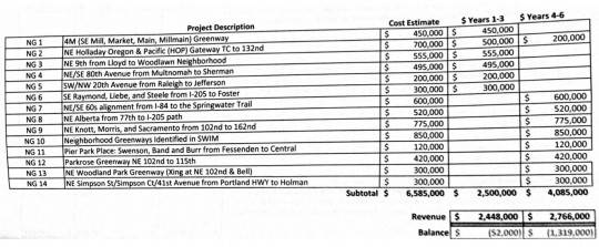
When it comes to bike access on residential streets, PBOT plans to use $5.2 million of Our Streets funding on neighborhood greenways over the next six years. Here are the specific projects they’ve prioritized:
Sidewalks, with a total of $18.7 million in Our Streets revenue allocation over six years, are the largest expenditure in the safety category (10.8% of the total revenue). But Safe Routes to School, with $17.4 million, is a close second.
The largest expenditure by far would be paving on busy streets. PBOT’s current plan would allocate $59 million — or 34% of the total revenue collected — on those types of projects.
I’ll share the complete project lists as soon as PBOT uploads them to their website.
Stay tuned for more coverage of the Our Streets funding proposal.
UPDATE: See detailed maps of where the city wants to invest in our latest post.


Thanks for reading.
BikePortland has served this community with independent community journalism since 2005. We rely on subscriptions from readers like you to survive. Your financial support is vital in keeping this valuable resource alive and well.
Please subscribe today to strengthen and expand our work.
Anyone know what kind of metrics they used to determine the projects that ended up on this list?
Hi Bob K,
The projects were mostly identified through the usual channels PBOT is using these days… like their High Crash Corridor program, their neighborhood greenways program, their pavement analysis system, neighborhood associations and their reports like the East Portland in Motion Plan (EPIM) and the Southwest in Motion (SWIM) plan. Other projects are on the list probably because they are shovel-ready and/or already have broad support and/or some type of funding commitment (grant or otherwise).
Does anyone know if the Central City project would include a full protected bike lane from Bway bridge to PSU? Would seem a key way to connect many ppl to most of downtown safely instead of in a door zone as it is now.
Blake,
The exact location of bikeways in that project haven’t been identified yet. Getting those lines on the map is a big priority for PBOT because — as Geller explained in the meeting this morning — PBOT wants to have a clear vision on paper in order to hasten discussions with various interest groups like the BTA, freight committee, Portland Biz Alliance, and so on.
A PBA rep at the meeting today said: “our concern [about the protected bike lane proposal] is that the list is amorphous”.
Geller is looking toward the current update of the Central City Plan where he hopes a detailed list of potential protected bike lane routes will be fleshed out.
Improvements are needed yesterday if PBOT wants to justify their awful signs for #fastbikes. Someone on a bike was hit by a car on Naito today at Columbia and while I don’t know if they were there because of the signs, the possibility exists. The signs indicate “#FastBikes Use Naito Blvd Bike Lanes”, despite that in at least one place (just on the North Side of the Hawthorne Bridge for people travelling SB) they direct people to a section of Naito that has no bike lanes. If they want to subordinate people who use bikes on Waterfront Park (which I think is terrible policy given the available alternative routes), they owe at least the minimum of not putting up signs that contradict with reality.
Please please please build a 9th Ave bike/ped bridge over 84. The Irving St /12th Ave bridge/Lloyd Blvd gauntlet is unsafe for bikes and a huge time sink. A bridge would be a big safety improvement.
The only alternative is across the MLK I84 bridge and down to the IRQ via sidewalk. I’ve been using this when 12th is out of reach. This bridge would be a vast improvement.
The list of residential streets bike projects: Is that listed in priority? Or maybe just by location? Is it coincidental that all the inner projects are at the top and the outer ones are at the bottom?
Suburban residents still get a free ride. Businesses don’t pay enough. Administrative costs still too great. Defeat this and raise the gas tax. They expect to buy us with four promised bike projects.
And those four promised bike projects are spread out over six years. Six years is far too long for these much-needed improvements; we needed these projects yesterday, and other major cities are rolling out entire bike networks in just 1-2 years. We ought to be able to do the same.
As for the tax itself, I was in support of the progressive income tax until I found out it would only apply to Portland residents. It needs to apply to all people who work *and/or* live in Portland if it’s going to be fair. I also like the idea of raising the gas tax – I own a car and drive occasionally, and I’d be more than happy to pay 30-50 cents more per gallon if it meant better transportation facilities for *everyone*.
there is absolutely no certainty about even those four projects. (see the 28th debacle for a recent example.)
and while we all wait for another 2, 4, 8, 10 years for a few hundred meters of “protected bike lane” to materialize even more arterials and commercial roads will be re-configured without the addition of bike infrastructure. bike lanes may not always be “world class” but they are the kind of cheap and effective “low-hanging fruit” infrastructure that can be built today, not maybe…possibly…a decade from now. let’s build the network now and protect it when funding is available!
It’ll take 6 years to just get through a public process in this City, and the results will be washed down and so meager that no one is offended or happy.
But think about all the potential hurt feelings that can be avoided with lengthy public input processes.
I’ve decided on a new name for taking the lane and rolling at a relaxed pace on major arterials: “the public process.”
This. We are going to need a lot more protest rides – and everyday taking the lane where we’d like to ride – if we’re going to change the status quo at city hall.
“It needs to apply to all people who work *and/or* live in Portland if it’s going to be fair.”
and it needs to apply to all the people simply driving through from one suburb to the next…
If bike commute mode share is 6%, shouldn’t we get at least 6% of the funds? That would be $10 million and change…looks like they’re shortchanging us with their proposed spending. I agree that a gas tax looks like the equitable way to do this. Or, if they want to be really mean (and regressive), add it to the registration fees for cars registered in town.
Multnomah County is not paying for the new $7.3 million dollar Fanno Creek bridge on SW Oleson Road that is used by many Portland residents.
What’s your source for claiming “many Portland residents” use Oleson Road?
Maybe if you built it, people would use it.
They project administrative and non-compliance losses for the proposed income tax of about $66 million over six years.
For a gas tax, non-compliance wouldn’t really be an issue and administrative costs would be much lower. This is in addition to all the other good reasons to favor a gas tax over a city income tax.
I wonder how much money they will have wasted by not grabbing parts of the old Sellwood Bridge for the Flanders and 9th Ave bike/ped bridges.
Old Sellwood Bridge is still there in in full use, they still have this opportunity. Not that I’m that enthused to try to retro fit pieces of a 90 year old bridge into downtown.
it’d cost more to move parts of the Sellwood than build new.
Not sure how anyone would envisage a tax being collected by the City of Portland on people who don’t live in Portland except indirectly through already proposed business tax or ???.
By having a local option gas tax as used already by more than a dozen cities. That way on those occasions when someone happens to buy gas in one of those cities, you’re paying a dollar or so into THEIR transportation fund. I’ve bought gas occasionally in Eugene and Tigard, so they’ve gotten a few bucks from me. It’s time for Portland to do the same.
Then what does the map posted on this site https://www.portlandoregon.gov/transportation/article/497799
represent? It is linked ‘Info on Neighborhood Greenways Section’ of the page posted on their Facebook last week (https://www.portlandoregon.gov/transportation/index.cfm?&c=65945).
This seems like a very different plan than the PDOT 2030 Bikeways Plan and current Portland Plan represent. For instance, the 20’s, 50’s, and 70’s bikeway alignments have changed or disappeared even as of a couple weeks ago the 20’s is in planning and some of the 50’s are constructed, especially south of division.
It makes it hard to advocate for something when the plan keeps changing, forgive my ignorance if this is clear to anyone else? I’m pretty confused.
As always, I ask the question…is there any budget line item(s) for secure long term bike parking? (Was there any discussion of this during this meeting?)
And nothing for trails..
True, but isn’t that more parks/rec than transportation?
PBOTs own Bicycle Master Plan for 2030 intially kicked trails down the road as an aspirational goal.Separated trails are every bit of transportation..the Springwater was initially a ‘rec’ trail until the 3 bridges link over McLaughlin was completed, along with the Oaks Park to OMSI segment.. what is the daily transportation count on that ‘rec’ trail now? So how ‘recreational’ is the connection of the Esplanade to Swan Island? With over 10,000 jobs on Swan Island, with only one road in or out, would a separated trail be of value to the workers AND the businesses on Swan Island who deal with capacity daily? As BMP2030 states, until folks feel safe, they will not ride in numbers sufficient to accomplish the goals of BMP. http://www.portlandonline.com/auditor/index.cfm?a=294097&c=31608 read em and weep.
I think we’re getting tripped up on vocabulary. I think of “trails” as dirt single track for mountain biking. I think you’re meaning it as MUPs or bike paths?
Paved MUPs/”bike paths” are still largely under the umbrella of Parks, except for special dispensation for heavily-used paths like the Springwater and Esplanade (so I’ve heard; I’m definitely no expert on what’s what in Portland/Multnomah County). In my neck of the woods (Oregon’s Washington County), travel on most MUPs is scofflaw behavior after “dusk”, since they’re technically park trails to be enjoyed by casual strollers during daylight hours and are “closed” at night. Everyone knows that you’re mentally unstable if you ride a bike after dark anyway, right?
The irony is that we expect those on bicycles to get off the paths (presumably for “safety” reasons) and revert to use of 40-mph roads with narrow or no shoulders and no signal detection for bicycles precisely when visibility (i.e., “safety”) becomes a bigger issue—at night. Well, I guess the real expectation is that no one will be foolish enough to ride a bike at night, as I said.
PBOT putting a line on a map through a park doesn’t mean a path through the park will get built. Parks controls what happens on parks property.
It would be nice to fix the suddenly disappearing bike lanes, keep the existing bike lanes free from encroaching brush in the summer and gravel during the winter before building expensive bridges across freeways. Getting to Terwilliger from downtown you get pinched at Duniway Park before the left turn prior to OHSU and the city cannot even keep the brush from encroaching. The lane is essentially gone where Terwilliger crosses Capitol HW. The blackberry vines push you into the car lane going from Barbur to Taylors Ferry.
There have been plenty of maps plotting bicycle accident locations. I don’t see how these bridges help make cycling safer. They look like high visibility but projects that make it look like the city is doing something useful but really don’t deliver much.
Or used as prima facie evidence that the “Bike Lobby” is out of control, getting everything it wants. Clearly not a true statement, but one that is provided ammunition by “visibilty” projects if they cannot be justified as providing value for money relative to other projects.
Why a new bridge over I-405 at NW Flanders Street when SW Naito Pkwy greatly needs one at SW Whitaker Street so that it would connect SW Terwilliger Blvd and the main OHSU campus to the south waterfront? SW Portland needs the Red Electric Trail and many overhauls on SW Capitol Highway, SW Dosch, and SW Hamilton.
I recently tried to get from Barbur to the Gibbs St bridge, and I agree that crossing Naito is horrible. I don’t think a bridge is the right answer though, because it would require stairs and/or ramps to get up on it. An at-grade, signalized, crossing of Naito at Gibbs or Whitaker would make the world of difference for bicyclists and pedestrians.
If there’s a project that you think is worthy of street fee revenue dollars, let it stand up on its own merits instead of needlessly attacking worthwhile projects in other neighborhoods. Thanks.
No one is attacking projects. But fairness dictates that some of the money collected should be spent on the west side. Tired of us west siders subsidizing east side projects. Very little is being spent on the west side while the east side gets bike boulevards, bike signals, etc… It’s dangerous over here and no one is doing anything about it.
There’s a very nice (and very expensive) cycle track under construction on SW Multnomah Blvd.
Um, isn’t NW Flanders on the west side?
I’d almost say I was in support of the bill with the breakdown as shown. However it seems that there should be dramatically MORE bike infrastructure spending in there, more safety, and less actual paving.
At this point, the city desperately needs something. But what I’d like to see is a real solution on going non-car and getting money BACK to citizens for not having to maintain the insane infrastructure that automobiles need.
…how’d that be for a campaign slogan. Go bike, get a $2500 a year check (and up) or something of that sort for the infrastructure savings you’ve helped the city to achieve. I realize the city needs at least 15-20% of the city commuting by bike to really see that, but it’d be sweet and probably would make a good campaign.
So, lots of planning for 4 years and a carrot of actual improvements in 4-6 years? I think i’ll pass.
PBOT, spending money they don’t even have yet. great.
Other people’s money is GREAT!
Thanks for the heads up on the live feed of this City Council meeting.
Please don’t blithely say, “Businesses don’t pay enough.” We pay a LOT of taxes and it’s a huge burden as it is. To add significantly more (which this does) will make it even harder for us to survive.
i love bikes, as does my wife and her business. i’m not supporting getting triple taxed in our household for something that could be easily done w/ a gas tax.
easy solution, stop paving 12 foot travel lanes, charge for ALL on street parking, stop subsidizing surface parking lots, Done and Done
Where is PBOT creating these 12′ lanes, where are these parking lots that they are subsidizing, and how politically feasible do you think it would be to have permit/metered parking throughout the city?
PBOT’s standard lane width is 10 feet and 11 feet for truck or transit lanes.
Hopefully this is a poorly implemented as the Arts Tax and I can avoid paying it too.
9th is a much better route than 7th. There is room for a much nicer bike lane on 9th through NE Broadway and then a Greenway from there. A path currently exists through the park flush with 9th, it just needs a bikeway upgrade. 7th is high traffic and mixes with the streetcar in Northeast. In Southeast, 9th would be a better greenway and crosses Powell over a pedestrian bridge and reaches all the way to Holgate.
I would much prefer a bridge on NE 7th. For one, 7th is closer to the businesses along MLK/Grand. NE 7th gets you all the way from Alberta to Division in a straight shot, and much of the bike infrastructure is already there. Adding bike lanes or neighborhood greenway style improvements to 9th through the industrial area would meet huge opposition from the industrial users of the district.
Where the streetcar runs along NE 7th, it does it on the inside of the road. There could be some improvement to how the bike route crosses the streetcar at NE Weidler, but other than that there’s no real conflict.
7th’s traffic volume north of Broadway is way too high to support a greenway. It would require several diverters. 9th is a quieter route but the pavement is awful and the routing through Irving Park is a concern.
Also Jonathan, 9th does intersect with Tillamook as well.
I’ve never found NE 7th to be an uncomfortable street to cycle on, and with MLK only a block away, there’s no reason some diverters couldn’t be installed.
So, paving 9th, under maintenance funding, would also be a safety project for bikes…
Putting the cart before the horse aren’t we.
If it’s business as usual with city revenue and PDOT then the horse is a donkey, and the cart is a Radio Flyer wagon (a newer plastic one, not one of the cool metal retro ones). But hey, it’s fun to dream right?
A protected bike lane on NE Broadway from 24th to the Broadway Bridge is nice to have, sure, but there is already a continuous bike lane there. It’s NE 24th to the Hollywood district that improvements are really needed on NE Broadway.
Safety first! I’m surprised people can look each other in the eye and seriously argue that freight mobility is more important than vision zero – I’m sure most Portlanders would disagree that fatalities and injuries should be part of our transportation plan.
Oh, yeah. Vision Zero. Whatever happened to that one?
Until the costs of stuff gets too high and the truckers that drive most of it to out stores tell us it’s the bad roads and congestion. Time is money when the engine is running but the truck ain’t moving.
I was prepared to endorse the fee, but these projects (except for the Greenways) are weak sauce. Where’s my Sandy, Hawthorne, Foster protected lanes? What about commercial Greenways on Alberta, 28th, NW 23rd? At this rate Portland will be out of the rankings completely by the time they own up to the fact that these meager projects died in public process.
paint is cheap ‘infrastructure’.
After getting redone next year Foster will likely not be touched for a decade.
Except that US PIRG just released another report (this morning) showing that Millennials continue to drive less & less. In ten years—with all that is going on right now—a lot can happen that might upset the regular way we’ve done things in the transportation realm.
http://uspirg.org/reports/usp/millennials-motion
What about the west side?
‘Alternate Streets’ means paving the dirt roads to provide a minimum 16-18 foot shared use space on low volume roadways, likely posted for 15 mph, per ORS statutes.
“This 53/47 split would not meet the demands of a coalition of advcocacy groups that includes the Bicycle Transportation Alliance, Oregon Walks, Coalition for a Livable Future, and others, who say anything less than half the funds going to safety is ‘insufficient.'”
Good for them for standing firm. But I have to ask why, since this is an entirely new revenue stream, presumably in addition to the other existing ones we’ve been drawing from, couldn’t 100% go to something sensible like safety, or bikes, or something groovy like VISION ZERO?
I would like to imagine that our city fathers and mothers could put together a package that inspires, that doesn’t take dozens of pages to communicate.
Of course as others have already said here making Christmas lists in April seems kind of premature, especially if Santa Claus wasn’t invited to serve on the committee.
Again SW Portland gets screwed. All the bike funds gets spent on downtown or East Portland. A big priority should be bike lanes on Shattuck heading up to the Alpenrose Dairy’s Velodrome.
Uh Dave, how much of East Portland have you seen? It’s not exactly over-flowing with safe bike infrastructure.
The East side has significant bike infrastructure. Bike boulevards, bike signals, etc… We aint got jack on the west side. The most they have done in recently years is paint a stripe on Beaverton hillsdale Hwy. It’s pathetic to see the different. I feel safe riding a bike on east side but not on the west side. Come on over and I’ll give you a tour.
The “east side” and East Portland are two completely different places.
East Side and East Portland are the same thing to most people. What’s your definition.
82nd Ave.
= WEST of East Portland
Whatever man, you know what I mean. Tons of bike infrastructure on the east side, or whatever you define it as. Very little on the west side. That’s my point.
Also a massive amount of the population on the east side
I don’t think anyone is arguing against spending some money in the SW, but the projects there are almost all exponentially more expensive (mostly due to narrow roads and topography).
Dave, when you refer to East Portland you’re referring to the lowest income area in our city which has woefully inadequate infrastructure.
East side vs. East Portland makes a big difference.
The east side is anywhere east of the Willamette (excluding North Portland?). East Portland normally refers to the area east of 82nd / I-205, which was not a part of the city until the 80s/90s. This is a map of the boundaries of the East Portland Neighborhood Office:
http://www.portlandoregon.gov/oni/48714
Do you know how expensive bike lanes would be where you are proposing. That would involve major earth moving, new pavement for a shoulder. This is going to be exponentially more expensive than just throwing down some new bike lanes with paint.
So no bike infrastructure on the west side then? If you have a bike, you’ve gotta live on the East Side? Dude seriously?? So all my tax money should just be spent on the east side? That’s not right.
I lived in SW the first year I lived in Portland. Then I moved to SE.
Sure there should be more bike infrastructure in SW, but there are a very limited amount of affordable projects in the area due to the topography.
I’m just a pragmatist. I’d rather spend money on low hanging fruit projects (all around the city) than save it all over a couple of years to put in one or two mega projects in one specific neighborhood.
So some protected bike lanes in downtown and a few new bridges? Good start, but hardly ambitious in terms of building a network of protected lanes.
Sorry to be a downer, but ….
At this point, I believe that any proposed bike infrastructure could be shut down or changed into a substandard form by a business association, a minister of a church, an owner of a movie theater, an anti-bike zealot in a neighborhood association.
No one in the city or PBOT wants to spend any political capital on bike infrastructure, but will readily make promises to get support.
Fighting over scraps is exactly what they want you to do. Divide and conquer. I was excited about the Street Fee because I thought it would make a meaningful difference. If they’d proposed 10x the improvements than this I would be stoked. If they had proposed 5x the improvements I would be excited. If they had proposed 2x the improvements it would have been enough to keep me in the yes column. What they have proposed is an insult, and designed to have us fighting each other.
I refuse to play that game, especially since what hasn’t been proposed (20mph speed limit citywide, real diverters on Neighborhood Greenways, etc) would cost nothing compared to even these scraps.
Powell is between 7-12 blocks south of Division. Sure, that’s more than the three blocks from Alberta to Prescott, but it’s a quick drive for someone in a car, if Division is clogged and sufficient auto diversion is installed on Clinton.
I guess I should have said “if Division is calm and low-speed.” Congestion is a good thing….
If everyone commenting here about a gas tax showed up at City Council meetings to testify, it might actually make a difference to the conversation.
Is this list a “done deal” or is it just an example? I’m wondering if it could be a bait & switch situation to the betterment or detriment of any given constituency.