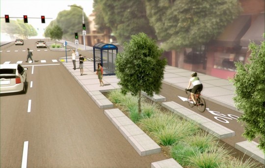
(Image by Owen Walz)
First in a week-long series about the BTA’s five new advocacy campaigns.
More than anything else in central Portland’s bike network, commercial corridors are the missing links.
Hawthorne, Belmont, Division, Mississippi, Alberta, Burnside, Fremont, NW 23rd, NE 28th: the neighborhood commercial districts that grew along Portland’s old streetcar lines have become the jewels in Portland’s crown — streets that make the city worth visiting, living in and caring about. They host a rapidly increasing share of local homes, and the businesses that line them — groceries, hardware, beer, music, shampoo — are the destinations for a huge share of the city’s trips.
But none of them has anything more comfortable to bike in than a door-zone bike lane, and many blocks have narrow, out-of-date sidewalks without much greenery.
This summer, the Bicycle Transportation Alliance has started a quiet campaign that is looking in an unexpected direction to create a better model: Northeast Broadway, from the Broadway Bridge all the way to Hollywood.
A call for better walking, too

(Photos: M.Andersen/BikePortland)
The BTA’s lead staffer on the campaign, advocate Carl Larson, said that though the BTA is trying to convene a conversation about how Broadway could be better and wants a high-quality bikeway like the one pictured above to be part of the conversation, it’s not wedded to a particular route or design.
Nor is a bikeway seen as the most important ingredient needed. Larson said what Broadway needs would be “part of a larger street treatment that improves, particularly, pedestrian movement up and down the street and across it.”
“We don’t have a set plan that we are trying to put in place,” Larson said. “We are truly trying to build consensus within the neighborhood and with businesses.”
To that end, BTA volunteer Chris DeLaney has been going door to door talking to businesses about what they want.
“Right now we’re hearing that crossing difficulty is a really serious concern and speeds are a real serious concern, and I’m pleasantly surprised to learn that lack of bike parking is a serious concern for many businesses on Broadway,” Larson said.
A route with potential

There’s no question that linking the dense, commercially rich Hollywood directly to the Rose Quarter area would be a huge boon for biking.
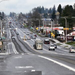
The roughly 2.5-mile route goes past numerous shops that households in the extremely bike-friendly neighborhoods nearby would, presumably, love to access by bike, but may not be because of the fast-moving traffic a foot or two away from the current bike lanes.
Larson said the best route might turn out to be along Broadway, Weidler or both. The exact eastern endpoint isn’t fixed, either.
But reducing the number of standard lanes on Broadway or Weidler in order to improve biking or walking access would make it much easier to cross the street and more pleasant to sit in a cafe alongside it, Larson said.
“By slowing down traffic it would make the businesses more visible,” he said.
Advertisement
A new model for advocacy
Sending a volunteer to gather business advice early in the process of planning a bikeway is something neither the BTA or the city has tried before.
The BTA hasn’t been shy about saying that the tactic was missing during the recent effort to redesign Northeast and Southeast 28th, which was scotched after a few businesses vehemently opposed to parking removal mobilized neighboring shops against the city’s plan.
“Business leadership has to be there if it’s going to work,” BTA Director Rob Sadowsky said in an interview. “It’d be nice if the city had the funding or the talent to do that.”
Larson referred to the work as “just patient relationship and consensus-building.”
“We see this type of work as necessary to pull off something like what the city wanted to do on 28th,” Larson said.
“I don’t know if this will be our job forever, to be cuing things up for the city,” he continued. “But right now, there is not a real commercial cycle track in this town. … Hopefully after we have that, a commercial cycle track will be easier to envision.”
Quick take: BikePortland’s summary of the project
Where the idea comes from: Basically from the BTA itself, but they’re hoping more detailed requests will emerge from businesses.
What it might cost: Several million dollars for the treatment pictured at top.
Likely tradeoffs: Narrowing and/or reducing the number of standard lanes.
Obstacles: Sadowsky said he thinks that a plan like this would require, at the least, the official endorsement of the local business association. There’s also the matter of communicating to more Portlanders that making all-ages biking possible on a commercial street is fundamentally different than making it possible on a neighborhood greenway. “Even people on bikes sort of lack the imagination to see what it would be like,” Larson said.
How you could help: Contact Larson: carl@btaoregon.org or (503) 226-0676 x16. “Right now we’re really looking for people who have a stake in what happens on Broadway, who are connected to Broadway businesses or the neighborhood and have some energy or creative ideas about how the street could be better,” Larson said.
Check back each day this week for another post in our series about new advocacy campaigns.



Thanks for reading.
BikePortland has served this community with independent community journalism since 2005. We rely on subscriptions from readers like you to survive. Your financial support is vital in keeping this valuable resource alive and well.
Please subscribe today to strengthen and expand our work.
Besides (or maybe because of) the road design of Broadway, it has a terrible problem with speeding. I wouldn’t be surprised if average vehicle speeds on NE Broadway exceed the 20 MPH posted limit by a wider margin than any other street in the city.
People absolutely FLY down Broadway as if it’s a through boulevard rather than a business district with a lot of shops, pedestrians and cyclists. And the light timing doesn’t do much to discourage this, unlike downtown. Any redesign of NE Broadway has got to include a significant focus on getting vehicle speeds way down from where they are today.
I’m fairly certain Broadway’s posted speed limit is 30mph through the Lloyd District; that’s why cars hit all of the lights. It seems to be designed to get the greatest volume of car traffic from the Hollywood District to the Rose Quarter freeway ramps or to the Broadway Bridge and over the river. That said; people still go faster than 30 mph on Broadway all the time.
Broadway definitely has a 30 mph posted speed limit, but the lights are timed such that you have to go 35 to hit all green. Simply changing the lights so that you hit them at 25 mph would be an easy, big step in the right direction to slow down traffic.
“Hawthorne, Belmont, Division, Mississippi, Alberta, Burnside, Fremont, NW 23rd, NE 28th: the neighborhood commercial districts that grew along Portland’s old streetcar lines”
For everyone, I think there’s a handful of streets on that list that they don’t necessarily mind being left out of, either. Clinton and Ankeny could develop even further as human scale corridors unto themselves.
And speaking of streetcars, the modern system is pretty hand-tying when it comes to the part of that couplet west of MLK. Lots of unusable pavement.
Actually, I would love to ride safely on *all* of these streets. I currently take neighborhood greenways as alternatives to all of them aside from 28th, but it would be great if I could actually see what the businesses exist in the town that I live. It seems strange to me that I learn the most about how Portland has changed and grown when I’m a passenger in a car!
Well, right off the bat, I’d say any proposal needs to preserve most of the existing parking. The experience on 28th has made that clear. The illustration that opens this article suggests that the lesson wasn’t learned?
Fortunately, the main commercial part of Broadway is wide enough that there can be a wide curbside bike lane, a sidewalk level buffer between that bike lane and a parking strip, then two traffic lanes, and another parking strip. Trees can be planted in that buffer area. The parking strips can be truncated to provide turn pockets, as is currently done in spots.
Curb bump outs to shorten the crosswalk and constrict the road at intersections. Revised signal timing. Bigger, bolder crosswalk markings. Lots of bike corrals.
Remind me, is Broadway a future Streetcar location? That would affect the design.
John: The term “parking strip” has sort of changed recently. 30 years ago it meant the planted area between the curb and the sidewalk. It looks like this is how you meant it. Recently I’ve heard people use “parking strip”, to mean the asphalt auto parking lane. PBOT’s pedestrian program a decade ago decided to call the planted area the “planting strip” to avoid confusion. (I know the original meaning was “parking” as in “park-like”, but that is almost lost). And recently the “planting strip” is often a swale or stormwater facility, which is what the BTA drawing seems to show.
On busy shopping streets, it is more appropriate to have street trees, with paving between them, so there’s more room for people to walk, shoppers to shop, and cafe tables. Many restaurants on Division lost table space when the recent swales were put in. They could have gone on other streets, or at least not where the sidewalk used to be.
In the Northwest, the parking strip is not where you park your car, but next to where you park your car. The definition hasn’t changed, we’ve just got a lot of people who have moved here from places where it means something else. We should not be surrendering our language to folks from out of state.
http://www.portlandonline.com/auditor/index.cfm?a=407839&
17.28.011 Planting and Parking Strip Defined.
(Added by Ordinance No. 184957; amended by Ordinance No. 185397, effective July 6, 2012.) “Planting Strip” and “Parking Strip means the area between the curb, or in the case where there is no curb the edge of the roadway, and the abutting property line not improved by surfacing that is intended for the use of pedestrians. Any openings made in a surfaced area between the roadway and the abutting property line for the purpose of planting trees or other vegetation shall be considered part of the planting or parking strip
parking strip
Web definitions
The strip of grass between the sidewalk and the street in front of a house.
http://mrwestside.com/mortgage-terms/
Five Perfect Parking Strip Plants | Portland Monthly
http://www.portlandmonthlymag.com/…/five-perfect-parking...
Portland Monthly
Jun 4, 2013 – Planning a good parking strip garden can be a challenge. Part of the hardship of it is that you aren’t just creating a garden for yourself—
Parking Strip Planting – Portland Nursery
portlandnursery.com/video/garden-solutions/video-parkingstrip.shtml
One of the toughest places to grow plants is the parking strip. This no-man’s land between the street and sidewalk is hard to water, maintain and is pret
Garden Zone: More on parking strips, including city … – Blogs My story about planting drought-tolerant parking strips, “Parking strips designed for beauty and drought tolerance by Portland gardeners,” …
And if one goes far enough back and looks at the width of the wider parking strip in our oldest residential areas they are often ~10 feet wide which would have allowed a horse (sans carriage) to park and “refuel” and not stand in the street when hitched to a horse ring nor interfere with passing pedestrians. Though a wagon would have remained parked in the street.
Yes, a streetcar to Hollywood is in the current RTP, using either Broadway/Weidler or Burnside/Couch and Sandy. Seeing as though a streetcar on Burnside is DOA without the westside couplet, Broadway/Weidler is the odds-on favorite to advance into planning, whenever there is the funding and political will to do so.
Spending a billion dollars (or whatever) on a protected bike lane on Broadway would be nice for cyclists, but it is unlikely to do anything positive for pedestrians or businesses on Broadway. What will help both of those parties (and cyclists) is finding a way to slow down traffic – such as more frequent traffic lights or two-way traffic. Narrowing it down from three to two lanes is unlikely to slow traffic – in fact probably the opposite.
That’s interesting, cwhidbey – why would two lanes lead to more speeding than three?
While we’re talking possibilities, switching to two-way traffic would certainly be a big change but it’s one that has been done in a lot of US cities to reverse the “main street to through street” transition that happened 50 years ago.
This article might help. https://en.wikipedia.org/wiki/Traffic_Calming
It seems that there are quite a few factors involved in slowing car speeds, factors that have been shown to actually work. Take NE Brodway for example. I remember when NE Brodway was a 5 lane shit show with people driving 45 – 50 mph. When they reduced the lanes from five to three and posted slower speed limits, people reacted by driving slower. It was wonderful! I worked for a Business on NE Brodway at the time and the owner was totally against the lane reduction up to the day it happened but after he saw the changes in speed; the reduced noise; more folks walking to his shop from the neighborhood he changed his tune in a hurry.
Sorry if I was unclear, by “parking strip” I meant the “lane” where street parking goes.
The cycle path in that mock up is ridiculously narrow.
Almost like the contraflow lane on SW 5th and Lincoln. Don’t know how that configuration passed muster in final design.
Right now, NE Broadway is three auto lanes, one bike lane and parking on both sides. The mock-up appears to show two auto lanes left on the south side, so one auto lane (10′) plus a bike lane (6′) and a parking lane (8′) is 24 ft of space. Reallocating that to a transit island/parking lane with a bike lane between the island and existing curb could be 16+8, quite generous. You could even move parking/bus islands into the north side travel lane, add sidewalk between the curb extensions and still have a generous bike lane (8, 8, 8).
In the netherlands the standard width for a low-traffic cycle path is 8 feet (2.5 m).
I would really love to see this, but as I said last week, the part where it’s most needed is going to be the hardest place to build anything: between NE 24th and the Hollywood District. Either the number of vehicle lanes has to drop from 4 to 3 (as is happening on SE Foster), or parking has to go. West of NE 24th it’s easier to imagine a road diet on both NE Broadway & NE Weidler. The streetcar runs in the leftmost lanes, so even that’s not an issue.
Carl forgot “Comic Book Store”.
I live on 21st & Weidler. Broadway is a ghost town in the evenings, except for Swift, the smokers sitting at the sidestreet tables at Broadway Grill and Aztec. With the neighborhood demographics, Broadway should be packed with tables full of people and their dogs, more like a boulevard in Madrid. But the storefront space along Broadway is downright creepy, and traffic on Broadway and Weidler does not support the businesses along the streets. Cars are mainly headed to the Broadway Bridge and the I-5 on ramp.
Parking: there are plenty of empty parking lots in the neighborhood that have no economic value except during Blazer games, when they can make a buck. Otherwise they sit empty.
And as for the parking on 28th: if merchants can make more money renting the parking spots in front of their business to add tables, they suddenly don’t care about the two or three parking spaces that disappear. This hasn’t happened yet on 28th, but the most expensive dirt in the region is in the Pearl, and since people can walk to the businesses, the ten tables covering three former parking spaces are more valuable than three parking spaces that bring six people to the neighborhood.
A bike corral covering three parking spaces can bring 50 people to the block.
Broadway is going to change soon: the economics and demographics are there.
See, I think there’s a sort of groupthink and arrogance in looking at Broadway and saying “No, it should look like THIS.” Why, precisely, does Broadway need to look like a cafe-saturated street in Madrid? If it looks quiet at night, that’s probably simply a result of the fact that most of its businesses are daytime-oriented; that’s not in and of itself a problem. To my mind, it’s a stretch to say that Broadway poorly supports its businesses when, if you look at that street, you will not notice a lot of vacancies or “For Lease” signs up. I’ve lived in the neighborhood for three years and witnessed relatively little turnover in that time. Calling the street “creepy” is massively over-dramatic. The Swift does well, the Hop Haven does well, the Rose and Thistle does well, the coffee shops (Peet’s, Starbucks, Saint Simon, Caffe D’Arte) do well in the daytime, Costello’s is back open, Twisted has a loyal following, the new yogurt place has been hopping lately, Kitchen Kaboodle has steady traffic, the McMenamin’s and Azteca do well, Helen Bernhard’s has a loyal following and has been there for 90 years … I think Broadway is doing pretty okay being Broadway. I live, walk and bike on Broadway. I like it. I like that it doesn’t feel like every other overcrowded, same-y East Side commercial corridor (Hawthorne/Division/Belmont/Alberta). It’s a fine neighborhood strip. It has its own character.
I don’t know, this is an ongoing frustration I have with bike advocacy in this town. I think you could probably pare back Broadway to two lanes and put a more comfortable bike lane in there and it would indeed improve the street and its rideability. You could certainly put in more bike parking; the Swift in particular is crying out for a corral. But you don’t have to march into the situation with the attitude of “You know this street is kind of lame, but don’t worry, we’re here to fix it now,” along with a Photoshop mock-up of the street which looks like every other urban planning Photoshop mock-up of a street, that features no actual businesses in it or other identifying local character.
I’m not just looking at Broadway, I live there. How can expressing an opinion about my neighborhood be arrogant?
I think the redevelopment of the Lloyd district will be a big opportunity for the retail businesses on Broadway. I agree the demographics, with Irvington on the north and Lloyd on the south, should be great for retail.
I am of two minds about the one-way traffic on Broadway and Weidler. On the one hand, it does promote the “thruway” aspect of the street. On the other hand, it creates space to dedicate a lane to a bikepath/cycleway while leaving enough parking and traffic lanes to, hopefully, satisfy retailers’ concerns and accomodate a future streetcar line. On balance, I don’t see a huge need to convert these streets back to two-way.
It would be ideal to fit a two-way bike lane/cycle path on Broadway. Anyone think this can be done safely?
Broadway from 24th to 37th is two-way and hence it will be tougher to make room for bike lanes. (A good reason to not make the rest of Broadway two-way?) My feeling is, fix Broadway west of 24th, and if the results are as visibly good for retail business and neighborhood livability as hoped, then the businesses east of 24th may be more supportive of changes to that part of the street.
I think the plan should go from Hollywood to Broadway Bridge–destination to destination. The people who will use it are already convinced. In my opinion, the people who don’t value bike infrastructure should not control the outcome. They wont be convinced until I ride past on my bike and poke a buck in their tip jar.
I agree John, yes this is the one primary reason to “keep” some of the older couplets in operation…at least until more structural changes are permitted in our public street spaces. Otherwise most arterial couplets along community commercial zones should be returned to their previous bi-directional operations.
There are two very “fatal” flaws in separated/protected bike lanes in the US and Portland [specifically], “right hooks” would get much worse because that much separation makes it even harder for a driver to see a cyclist in that lane that they (the driver) are crossing (which in itself is a ridiculous flaw!)
There are to many side/crossing streets without signals that cars would just hook right on…
the 2nd flaw which is very US and (even more) Portland specific is that many bike riders won’t stop for lights, especially in a protected bike lane where their speed and lack of focus will be higher. On Broadway there would need to be bike lights (no right on red) like the one on Williams/Broadway at every intersection making a bike commute much slower if they have to stop at many more lights. not to mention the slow down it would cause motorists trying to make right turns.
Its time we start thinking outside the box and making compromises (as cyclists and motorists) designing specific bike routes that only allow limited and heavily protected turns across protected (bike) lanes giving right of way to the cyclist more than the motorist.
Bike boulevards should be similar to Williams all through out the city by using one way streets that don’t cut through residential neighborhoods (for fastest commutes)
Speed limits for cyclists in business/retail sections to deter through riders/commuters just like motorists are deterred from taking heavy retail oriented streets with slow speeds and pedestrian crossings everywhere.
restricted access for cyclist and motorists giving fast options for both commuters… leading them through areas designed to be safe and fast(ish)
We just need to get away from all these retrofit solutions, which are not solutions at all, but band aids that barely stop the bleeding (literally)
I’m sorry, but there are too many intersecting cross streets and driveways on Portland’s inner city E-W arterials to make separated cycle tracks either safe or efficient for cyclists.
I agree: Sullivan Gulch trail as a route across eastside neighborhoods to the river might be a better infrastructure investment than Broadway/Weidler, as it uses the changes to the urban street grid imposed by The Banfield/UPRR/MAX infrastructure.
I think Sullivan’s Gulch trail has too many problems for it to happen any time soon. Even if UPRR agreed to allowing it to being built (itself a big if), the feasibility study showed that there’s no way to build it between NE 28th and NE 32nd unless the warehouses redevelop. Which is not to say that the city should give up on it as a long term goal, but changes to NE Broadway are feasible in the short term. Sullivan’s Gulch isn’t.
the mock up shows a bike-specific green signal.
The bike-specific green signal only protects those cyclists that are queued up at a red signal. Those cyclists passing through the intersection at a later phase of the traffic green light are more vulnerable from right hooks as a result of the separated spaces/lanes.
a bike-specific green should be fully separated from the car/truck green and right turns on red should always be disallowed. this is about the only thing that is *right* about the vancouver cycle tracks.
Regarding the “List” in the [great] photo of Carl…talk about summing the argument up so succinctly …I mean it is so true…I will not ride a block out of direction for my donuts!
Actually, it is a good list. And the damning reality of these four failing arterials is that their current [out dated] layout serves NO user very well. I hate to drive along them, park a car along them, ride a bike along them, walk along them/ cross, wait for a bus, etc. I assume they are not so great to live on…but then I do not have any experience there. So they really need to be updated and I am glad the BTA is now on it…along other stakeholders working on it.
I don’t think we should design urban bike infrastructure for the hammerhead cyclist who insists on riding through the central city at high speed without looking, slowing, or stopping.
LOL, who are you calling a hammerhead?
:rolleyes:
I would prefer to be called Hammerhead instead of “get out of my way! slow fat guy!”
that’s unfair, john. i almost always give the magic glowing traffic orbs at least a brief look.
From the Oregonian today (http://www.oregonlive.com/portland/index.ssf/2014/08/portland_street_fee_city_unvei.html#incart_river) on what the city would spend the Street Fee money on in the next 6 years:
$3 million – three separate protected bike routes, each totaling $3 million, in N/NE Broadway, Central City and Flanders.