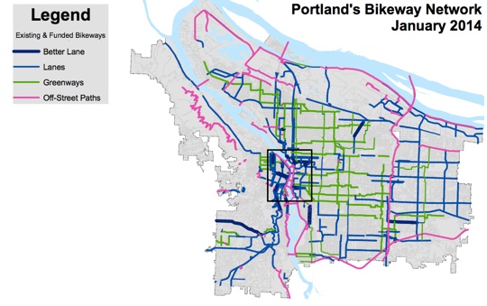
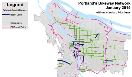
A map caught my eye at the monthly meeting of the PBOT Bicycle Advisory Committee last night. It was a prepared by PBOT bike coordinator Roger Geller and it showed all of Portland’s existing and funded bikeways (as of this month). It included four categories of facilities: “Better lanes” (protected bike lanes like cycle tracks and buffered bike lanes), “lanes” (standard bike lanes), “greenways” (residential bike boulevards), and “off-street paths” (like the Esplanade and Springwater).
Some of you might recall that I have a thing for bikeway network maps. We tend to focus so much on individual projects that I find it inspiring and informative to step back and see the network from a wider angle. These maps offer a quick way to assess things like network density, geographic equity, and connectivity.
Before I give our bike network a stress-test, let’s review our current facility inventory. According to PBOT, here’s the breakdown of our 368 miles of existing (331 miles) and funded but not yet built bikeways (37 miles) as of July 2013:
- Standard bike lanes: 180 miles (49% of total)
- Neighborhood greenways: 92 miles (25% of total)
- Off-street paths: 85 miles (23% of total)
- Protected bike lanes (a.k.a. “better lanes”): 11 miles (3% of total)
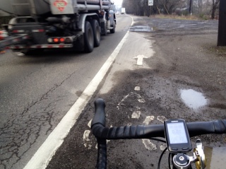
as a major connection on our bike network map;
but for obvious reasons, only experienced riders
dare to use it.
(Photo by J. Maus/BikePortland)
Seen on a map showing those four bikeway types, Portland’s network is quite impressive. But something struck me last night: Much of our network relies on standard bike lanes, many of which aren’t very pleasant to ride on. It’s almost become an accepted fact in bike advocacy, planning and engineering circles that standard, 4-5 bike lanes are not the type of bikeways that encourage new riders to start bicycling. Not only do they put people just inches from motor vehicle operators, they are also often in door zones or filled with debris (see image at right).
To reach the City of Portland’s bike usage goal of 25% of all trips by 2030, we must attract the legions of Portlanders who are too afraid to pedal alongside auto traffic with nothing more than a stripe of paint to protect them. Put another way, bike lanes are 1990s technology that do little to encourage cycling. They’re certainly not conducive to the “low-stress” conditions PBOT is striving for and the fact that they comprise 49% of our network might have something to do with our current plateau in ridership numbers. (And the fact that we’re falling behind in building protected bike lanes doesn’t help either.)
Back to the map from last night. So, if we agree that bike lanes aren’t adequate for the elusive “8-80” demographic, what would our low-stress network look like?
I asked Geller to create a new map without the “Lanes” layer. The result confirmed my hunch: If you want to ride in a low-stress environment, it’s nearly impossible to get from point A to point B. Gaps abound in Portlandia.
See for yourself. Here’s the full network map again…

And here’s the same map without the bike lanes showing (I’ve started calling it the “gap map”)…
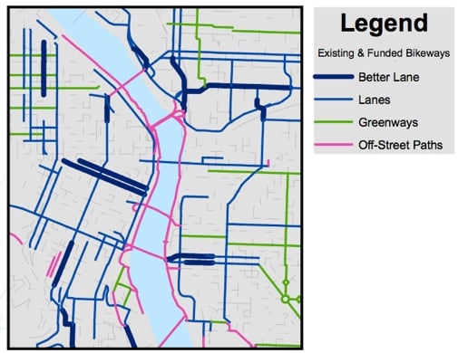
And here’s an up-close view of the central city with bike lanes…
And without…
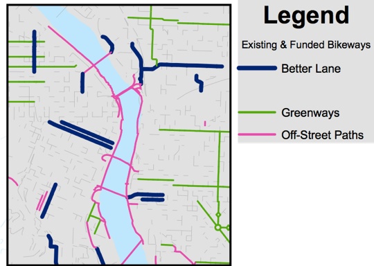
Seeing all these gaps in our low-stress network really helps explain why more Portlanders don’t choose to ride bikes on a daily basis.
Another thing you notice when we remove bike lanes from the equation is how crucial our neighborhood greenway system is. PBOT’s exemplary work on these cross-town, residential routes has created an important foundation for our network.
Now we need to build on that network. And we need to do it with more protected bike lanes that connect from neighborhoods to destinations. The good news is that PBOT is aware of this. They’ve already got $6 million in the hopper for network of protected bike lanes downtown, and you can bet there will be some big protected bike lane projects prioritized in the upcoming transportation funding package.
One reason Portland has stagnated in ridership and bold bike projects recently is the political and public perception that our bike network is already world-class. It’s not. Hopefully, Transportation Commissioner Novick, PBOT Director Leah Treat and other local leaders can start making the case that we have a long way to go and we need to more — and more connected — high-quality bikeways to get there.
— Reading this from outside of Portland? Give your bike network the low-stress test and see what it looks like.


Thanks for reading.
BikePortland has served this community with independent community journalism since 2005. We rely on subscriptions from readers like you to survive. Your financial support is vital in keeping this valuable resource alive and well.
Please subscribe today to strengthen and expand our work.
we are literally riding in the gutter… simple physics dictates that we ride among all debris cast aside by moving cars and natural debris collected in the bike lane by rainfall. avoid the log only to run over a broken bottle…
Brilliant. I have a pretty good mental map of those network holes but making this map is such an obvious way to illustrate them. Wish I’d thought to do it! Nice work.
This is also the best illustration I’ve seen yet of the need for a NE 7th / SE 9th neighborhood greenway.
I’m curious what the ‘better lanes’ are extending off each end of the Broadway Bridge in the Central City map? Maybe I’m a little fuzzy on the definition, but pretty sure there’s nothing but paint there defining the bike lane.
It appears to only be a buffer of paint that makes it a better lane.
I’d qualify “low stress” as it relates to greenways.
Although, within the confines of our neighborhood, I feel okay encouraging my kids–teens included, and even my mom of nearly seventy years for that matter–to ride in the lane on the local greenways, I’m very uncomfortable with the reality of their having to make highly alert and rational choices where those greenways cross the busier uncontrolled intersections, such as…
– NE 33rd Ave & Klickitat
– N Williams & Morris
– NE 7th & Tillamook
If the geenways are to serve as low-stress connectors, control treatments are needed where those greenways leave the relative safe haven of the cloistered residential neighborhood.
My suggestion to all traffic planners is to obliterate the image of the standard adult commuter from their mindset when planning for bicycle traffic…and replace it with images of grandma and grandpa, kids riding solo, and kids riding alongside parents.
I would likewise challenge PBOT and ODOT to nevermore depict the usual young adult in their marketing materials, and to make the same substitution of images of the elderly and of the very young getting around on bikes.
Planning for the iconic bike commuter is no longer good enough. We need “8 to 80” cities to be the new norm.
http://www.8-80cities.org/
The Greenways are my preferred route and where they are good they are great (lots of jogging strollers in the road) but in other places they feel more like wishful thinking.
How expensive will it be to finish the Greenways plan (both by adding new miles and by diverting through car traffic and improving intersections)? IMHO they seem like the best bang for the buck to provide citywide connectivity for everyone, but I don’t hear a lot about them and the expansion plans look modest: http://www.portlandoregon.gov/transportation/article/391056
http://a.tiles.mapbox.com/v3/coping-with-bikes.map-ulm0j2y9/page.html#12/45.5292/-122.6119
This system creating a half-mile Greenway grid network has been priced out at about $20 million all told. I tried to create a social movement around this concept, but it stayed basically a one man operation..so I got tired of trying and got elected as Transportation Chair of my Neighborhood association instead. Now I am working on a micro level…trying to give Burnside a diet between 41th and 71st so we can at least get a greenway from the 60th street MAX to Mount Tabor park and connect up the bike lanes that end on 71st with the Ankeny/Couch Greenways. In inner SE the 20’s is being worked on, the 40’s is “built”, the 50’s is “funded,” I am working on the “60s,” the 70’s has been promised for years and the 80’s and I 205 path’s are built. All these need improvements of course, but if someone from each region of the city worked in their own neighborhood…..
33rd at Klickitat does have the rapid flash beacons to alert motorists – with push buttons for cyclists. The RRFB cost about $40k, while a full signal would be $250k and attract all the neighborhood traffic to use Klickitat.
I get the concern about Williams at Morris, though Williams is one-way. It should proabably get an RRFB if it remains two lanes.
Tillamook is still in bike boulevard status and has not had the upgrade to NG level of access yet.
Unfortunately, the rapid flash beacon is advisory only, and not a control that people are required to obey.
Yes, but (rapid-flash beacon) + (pedestrian in crosswalk) = no excuse for not yielding. Not yielding to pedestrians in a crosswalk, assuming that the pedestrian did not “Suddenly leave a curb or other place of safety and move into the path of a vehicle that is so close as to constitute an immediate hazard”, is at least a traffic infraction. Will a flashing beacon embolden pedestrians to the point they venture into a crosswalk before all traffic has come to a complete stop? Who knows…
Right you are. My real-world experience at this intersection is that cars do not slow or stop even with the RFB unless and until I stick a foot or wheel into the actual path of auto travel.
Also, I’ve found that many–if not most–motorists don’t know rules for crap. They likely won’t know which kinds of signals are “advisory”, and will stop out of uncertainty–until they take their cue from other drivers and plow on through.
Sometimes just paint can do a lot, if it gives you more space. My biggest complaint about the standard bike lanes is that theyre just too narrow.
Yes, but the mantra is that paint isn’t a barrier, so it must be meaningful! Those yellow lines on the road are powerless, and therefore do nothing to prevent head-on collisions, amirite?
Paint, plus newly introduced auto parking.
Any way you can post larger versions of these images?
Are the planned N Williams improvements absent because they are not funded yet?
They are funded. That they’re not included is more a function of trying to keep the mapping effort and data tables behind them simple. Existing facilities slated for “better bike lane” improvements are not shown. This includes a segment on SW Multnomah near Multnomah Village that is an existing bike lane that is soon to be upgraded to a grade-separated cycle track. The only funded better bike lane improvement shown on the map are the buffered lanes for SE 17th.
But it looks like the 50s bikeway is on the map, and that isn’t even install yet.
I now live in St. Johns, but ride all the way to the Vancouver/Williams cycleway to get to and from work downtown.
The St. Johns bridge is hellish at rush hour. Ride on the elevated walkway and risk a gust of wind sending you either crashing into traffic or over the railing, or ride on the “greenway” lane and have pissed off assholes buzzing past you by mere inches.
Survive the bridge, and you have the joke of a “bike lane” illustrated above to get you into downtown…
Fortunately for me, I really enjoy the “long way” into and from downtown.
Have you considered N Central/Houghton/Concord greenways?
The Concord Greenway still puts you on to Interstate, and there is a “death trap” at the Larrabee Viaduct bridge, just south of Tillamook.
Why not use the Bryant greenway to get to Vancouver?
I usually cut over to Rosa Parks then hang a right on Michigan. From there Blandena takes you directly to Vancouver/Williams.
I think it might be useful to put the streets that are currently uncolored into various camps based on traffic volumes – seperate out neighborhood streets that are unsigned from major arterials with no or scary facilities
“Seeing all these gaps in our low-stress network really helps explain why more Portlanders are choosing to ride bikes on a daily basis.”
I think it’s interesting how the only solution discussed in Jonathan’s op-ed is more protected bike lanes. It seems to me that dozens of miles of better bike lanes would bridge those gaps far more quickly than a few miles of protected lanes. Shouldn’t we be discussing the merits of both options in a context-specific way?
Agreed. There’s lots of places where protected bike lanes won’t work or won’t get past a stakeholder advisory committee.
Drop all speed limits in town to 20mph. Quick, nearly free (I know, I know. swapping signs is expensive; so just stick a zero over the existing signs). Then, magically, the maligned bike paths instantly become much less scary because the speed differential between the cars and us shrinks. If European cities can do it (twenty’s plenty, etc.) why can’t we? And yes, enforcement is also needed. But none of this is half as expensive, long-term, or daunting as infrastructure upgrades which we can still work on. But this is potentially immediate (and we’ve started this speed limit reduction on the greenways already, which is wonderful).
There are bike lanes on streets that are 3- and 4- speed limits right?
European cities can do it because their cities are significantly smaller. Not as much of a hassle to go 3 miles across town at 20mph than to go 8 miles across town at that speed.
Apparently no one who rides a bike in portland everyday other than me shares this sentiment, but here it is anyway: we’re putting the cart before the horse…forget bike share (for now)…put all bike transporation related resources towards infrastructure making it easier and safer to get around by bike.
Absolutely! I ride downtown from NE everyday and regularly experience dangerous situations. It seems crazy to assume that people who a) don’t know the city well and are not familiar with the infrastructure b) aren’t regular riders, will be safe and feel secure.
very well said thanks
I respectfully disagree. NYC safely implemented a huge bike share system in Manhattan and Brooklyn in a much more chaotic and dangerous environment than Portland. It’s been a huge success. The more people we get on bikes in Portland -> the safer our streets become -> the higher the demand will be to improve our infrastructure.
I drive and ride 50/50 in and around Portland, and I agree with you wholeheartedly.
But we all know the “sputnik” moment hasn’t happened yet: $25.00/gallon gas.
Until then, I see the plateau continuing…
I love good illustrative maps like this!
These are great because they show how truly rare it is for Better Bike Lanes (even as overly generous as this term may be considering the reality of some of those) to be anything more than one-off fragments here and there.
It’ll truly be a sign that Portland is moving past bike-infra stagnation once it gets its first arterial intersection where two major routes (say, an East-West arterial and a North-South arterial) that both have cycletracks meet in a protected way (ideally *not* a Copenhagen Left http://www.aviewfromthecyclepath.com/2010/07/not-really-so-great-cycle-path-design.html but an Amsterdam Left http://wiki.coe.neu.edu/groups/nl2011transpo/wiki/ba51e/).
“Seeing all these gaps in our low-stress network really helps explain why more Portlanders are choosing to ride bikes on a daily basis.”
Did somebody accidentally a word here? Or am I missing something?
should be ‘are not choosing’
I find our bike boulevards more high-stress than bike lanes lately. They are choked with impatient motorists using them as two lanes of extra capacity for whatever congested arterial they parallel (SE Salmon running parallel to Hawthorne; SE Ankeny running parallel to Burnside, SE Clinton paralleling Division; SE 34th running parallel to 39th/30th…)
Motorists are smart -they’ve figured out there are these GREAT streets with zero stop signs that run for dozens of blocks, and have facilities to help them cross main streets (hawk signals etc). Who cares if the odd cyclist ends up crumpled in their fender?! If they can shave 60 seconds off the morning commute, they ‘ll do it.
Calling half of our bike boulevards “low stress routes” in this article is depressing, because I find many of them at peak commute times yo be high- stress.
I hear you Adam. I thought of making a point about that, but left it alone. I realize not all n’hood greenways should qualify as low-stress… And if you consider that, it just makes my overall point (that huge and numerous gaps exist) more clear.
This we can agree on and PBOT also knows it. One of the items proposed for the new transporation revenue will be to upgrade bike boulevards to neighborhood greenway level to the greatest extent possible (Retrofits). The NG standard aims for under 1000 cars per day on a NG and usually accomplishes this with diversion tools. Medians (Spokane/13th); Pocket parks (Klick/23rd, Holman/13th), or closures (N Central/Tyler).
Please divert: Salmon/20th; Clinton/30th; etc.!
Last time PBOT briefed us on the 50’s bikeway I pointed out that placing diverters at both Burnside and Glisan would cut down on traffic volume much more than just Burnside as there is significant southbound traffic coming into the neighborhood from Glisan. We ALSO have problems with Providence commuters parking in the neighborhood so we would really LIKE a diverter their.
PBOT told us straight up NO. Direct Quote: “You do not want to place two diverters that close together.” Our neighborhood has a grid pattern….it may not be complete but is extensive enough as locals mostly would not mind driving a round the block if it cuts down on cut through traffic. I see no problem with this even though they are only five blocks away and looking at the Providence traffic patterns I will tell you right now that without one 53rd south of Glisan will stay at higher than wanted volume southbound even after the 50’s bikeway gets built under current engineering.
I was not in a position at the NA then though, now I have a little bit more authority and placing a diverter there is on an agenda next month. PBOT may know they need more diversion…but they certainly are not acting like it even on a project that is NOT even built yet.
The Bike Boulevards / Greenways are the key to Portland’s bikeway network but they need a lot more diverters to curb all the cut through traffic abusing them. Its not safe for kids to share a road with cars that are traveling over 20 MPH.
We also need police to actually enforce the speed limit on greenways instead of treating it as a minimum with 10 MPH allowed over. I complained to the City about speeding on Woodward, which is a 20 MPH greenway and near a school. A police officer emailed me back to tell me that he observed most people were traveling at 25 MPH so he didn’t write any tickets.
In the mean time, I think the best thing we can do as a community is to start a campaign of “I take the lane because …” to educate cyclists and motorists why its safer to take the lane.
Your complaint is with elected Multnomah County judges who toss out citations issued below posted+10 mph.
Also, Woodward has not had neighborhood greenway treatment.
The police could still issue formal warnings for speeding which would have a psychological effect on slowing drivers down. There are a lot of “accidents” that drivers get away with because they don’t have a history of traffic tickets.
So, spend the same amount of limited tax dollars pulling over and warning motorists, but generate no offsetting revenue? How about elect judges who will get tough on speeding?
If significant numbers of tickets are getting thrown out because it’s easier to go to court and wait your turn to contest it rather than just pay it, we need to write more tickets.
Adam, exactly! I have had more than my share of annoyed motorists behind me on both Klickitat and Going…and I’m not exactly putting along.
Totally agree, Adam. Going is I great example of PBOT coming close but lacking the commitment to pull it off. The Going st greenway is great except that cars have found it and drive super fast down it. And it totally disintegrates at MLK heading west! Instead of using Skidmore, the bike is routed all over north Portland in the lamest way possible
A pet peeve…but it’s annoying that PBOT no longer shows older bike streets on it’s maps. IMO, many of the older facilities have signs and pavement markings (albeit faded) and are no better or worse than the mostly unimproved greenways currently depicted.
(I’m talking about routes, such as, 34th/33rd, Brazee, Skidmore/Mason.)
Many of these like the 30’s, 64th/5/7 th would instantly turn into a greenway at the level of Salmon with just sharrows being added which only cost about 5 grand per mile. I do not see this as any different that painting a yellow line in the middle of the road to tell cars where to drive.
One of the critical make or break features of high quality bike blvds/greenways are the arterial crossing enhancements and side street traffic control (flipping stop signs or bike bypasses) in order to make these low stress bikeways safe effective and low stress. So it would be much more helpful for the PBoT maps to include a colored “circle” [not red] for crossings that need upgrading or have been upgraded. This would be for purposes of project planning/ funding and way finding.
Agreed! This is how Going fails at MLK
That’s a very reasonable question, for sure, but the data overwhelmingly show that very few of the large but dormant reserves of Interested But Concerned/8-80 residents will ever consider even the “better” conventional lanes (after all, while narrow doorzone lanes are obviously terrible, the wider and “better” more recent conventional lanes just invite double parking still forcing you out into the street and overall just *feel* less safe than protected routes).
Basically, newly striped conventional lanes are pretty much flat-out ignored by at least 95%+ of residents, though I do admit they’re better than nothing for the small percentage of us who will bike anyway.
This article puts it pretty succinctly:
http://www.peopleforbikes.org/blog/entry/chicago-apartment-profile-lauds-protected-lanes-ignores-conventional-ones
It’s the psychological effect.
Conventional bike lanes are not big modeshare boosters (this is beyond an understatement), while protected infrastructure is. People go out of their way to use protected routes because they’re low stress. The result is that protected infrastructure (even in a few targeted places to begin with) creates its own demand.
It’s kind of like all those stats that show that way more people will ever consider taking a streetcar or a train than a bus along a particular route, so even though buses cost less in initial outlay (meaning you can put more in more places), the data consistently show that streetcars garner *way* higher ridership in the end. Imagine the state of public transit in Portland today if instead of creating a small handful of targeted MAX routes Portland had just decided to spend the same amount of money on building more bus routes all over.
While theoretically expanding bus lines onto every street in a city increases transit service, spending that same money on a few targeted high-profile streetcar routes (which people will often gladly walk 10-15+ minutes to) increases ridership far above those of standard buses.
It’s the same with “sexy” protected infrastructure. Experience and data show over and over again that cities just don’t get to 25% modeshare by building pervasive conventional bike lanes.
“That’s a very reasonable question, for sure, but the data overwhelmingly show that very few of the large but dormant reserves of Interested But Concerned/8-80 residents will ever consider even the “better” conventional lanes.”
What data?
I sure hope you do not mean Jennifer Dill’s study of Geller’s categories. In the Portland area her study found 6% strong and fearless (a offensive and divisive label), 9% enthused and confident, and 60% interested but concerned.
Moreover, Dill’s study reported an average comfort level of 2.7 for a crappy conventional door zone bike lane and a comfort level of 3.2 for a protected bike lane (scale of 1-4). Are you really trying to argue that people in PDX would not find an 8-12 foot buffered bike lane about as comfortable as a protected bike lane?
http://web.pdx.edu/~jdill/Types_of_Cyclists_PSUWorkingPaper.pdf
I should also point out that the German cycling revolution is built on bike boulevards, door zone free bike lanes, and abolition of the mandatory side path law (with signage!).
an offensive
…and traffic education with tough licensing standards, and stronger police enforcement of traffic laws.
wasn’t all that “data” just based on people answering surveys? I am still convinced that those numbers are VERY overinflated, and many (if not most) folks are not really “interested, but concerned” and in fact will not leave their cars unless they are absolutely forced to. People can just simply continue to say “well it’s not safe enough” regardless of what infrastructure is installed.
agree completely. i think reversing some of the huge subsidies for motoring would do more to get people on bikes than a few cycle tracks here and ther.
Nice article. I think the “fill the gaps” idea is exactly right if we want to get the interested but concerned group riding.
And, give me a badge, a radar or laser speed gun, and a ticket book one day/week, every week, and I’ll see what I can do about the speeding problem. Deputize enough of us as a “Traffic Enforcement Auxiliary and maybe there won’t be as big a need for a Street Fee, either.
Don’t get me wrong guys, good article. But it sure is not much of a news flash for those of us who ride a bike in this city.
And a Sullivan’s Gulch Trail would put a nice pink line right through the center of the map.
Survey responses in many different cities (and, frankly, modeshare data whether people were surveyed or not) repeat those kinds of findings over and over.
For example (http://sf.streetsblog.org/2013/11/05/how-a-poll-showing-sfs-pro-bike-attitudes-can-change-the-conversation/):
the dutch have had exceptionally high cycling mode share for over a hundred years. i think the munich/berlin model of going from 6% to 15-18% mode share without spending billions of euros is more relevant to pdx.
“My Danish coworker in the Netherlands once confided in me her hushed criticism about how freely the Dutch “allow children to just bike around anywhere. We would never allow that in Copenhagen.”
That’s exactly what I did growing up. Granted it was the suburbs so traffic was a little lighter. But all my friends and I biked all over the place starting at about 8 years of age. Would I allow my kids to do it Portland, I’m not sure, but I wouldn’t rule it out completely right now. I think this is more of an issue with parenting changes over time.
Side Rant-sometimes i just wish this site could have a dutch/danish free discussion about something.
See my above post about my opinion of surveys.
“One reason Portland has stagnated in ridership and bold bike projects recently is the political and public perception that our bike network is already world-class. It’s not.”
Put this on repeat and shout it loud.
so 1 person touched on all the garbage in the recycling lane but not one has said anything about street cleaning. flats are pretty stressful to me! in most other cities in the united states they have regular street cleaning and actually make money off of it through parking tickets. It seems pretty clear that the people that make the decisions that affect riding conditions for cyclists either dont ride a bike or dont actually care anymore than the bare minimum needed to get your vote for city council or whatever. am i just a jaded 2nd class citizen? (the implication is that all cyclists are treated as 2nd class citizens)
I agree! Portland street cleaning is terrible, and their parking enforcement is terrible, too! I lived in Vancouver, BC for 4 years and if you parked in a zone marked for cleaning you got towed. If you parked in a bike lane, you got towed. If your meter expired, you got a ticket. Parking was expensive, hard to find and if you screwed up there were consequences! As a result, people walked, took transit and biked. Portland could take a lesson.
If you see a car parked in the bike lane, call 503-823-5195. This is the City of Portland’s parking enforcement hotline. It does work. I call it about every two weeks. Usually for cars parked across the sidewalk blocking it entirely for peds. It’s highly satisfying to see the little enforcement smart car pull up and slap a ticket on the windshield!!
I’ll tell you all about some world class bikeways! I’m in South Korea right now and one can ride virtualy the length of the entire country on a beautiful separate bike path complete with its own bridges over waterways. I’m only here for a few weeks, but I rented a bike and I commute to the class I’m teaching on very low stress separate bike paths. Granted, the country has plenty of work to do when cyclists have to use the roads to get to their ultimate destination if it is away from the bikeway, but there are many people of all ages and abilities using the bikeways to walk and ride all over town at all times of the day and evening — and right now it is 20 degrees here! I have riden on the streets of Portland for 25 years, but when I see a city (Chuncheon) with decent separated bikeways, I realize how far we have to go at home.
Share some geotagged photos…via flickr so we can learn and also plan a future bike tour. How are the camping and hostel lodging options?
We moved from SE Portland to Hillsdale / Multnomah Village. It’s too scary and the routes are complicated. I’ve stopped biking to work. Otherwise, there are a lot of things we like about our new neighborhood. We need more biking infrastructure. Plus, I don’t think any drivers pay much attention to speed limit signs.
@Humongous Ed: Regarding the inadequate width of many bike lanes: in Washington County, Cornell Road was recently resurfaced from Cedar Mill east to the County line. They did an excellent job of squeezing in at least a tiny bit of space for bikes in several trouble spots along the lower portions. So far, so good, within the obvious budget constraints.
Then you get to the upper portion by the DR Horton development, where a beautiful bike lane was developed when the houses were started. Very sadly, with the new pavement someone elected to greatly REDUCE the width of the lane. Even my daughter, an experienced Cat 3 bike racer, now feels unsafe climbing the hill in that lane. At near age 70, I won’t climb Cornell in the dark in the winter any more. Ed is right: lane width is a frequent problem.
True, the Dutch had exceptional bike modeshare and up until about the 1950s it kept on growing, when all of a sudden a combination of rising incomes and car-centric city planning saw bike modeshare decline significantly until about 1980 (tragically, cyclist and pedestrian death rates also shot up during this period). The modern Netherlands is a wealthy nation and as with other countries generally the more wealth the more cars. They’re still pretty car-crazy. The 3-decade steady decline of biking there could’ve easily continued or accelerated had they not stepped in and developed via trial-and-error all their clever infra solutions.
As for cost, protected infrastructure doesn’t necessarily always have to cost that much more than conventional bike lanes–in some cases it’s even simply just using more or less the same amount of paint but reversing the order of the parking and the bike travel lane.
And of course even when protected infra does cost more than conventional unprotected infrastructure, both are still way cheaper per mile than the stuff cars get (on the policy side this is of course why fighting for even incremental increases in bike-infra funding can make a big difference). If you factor in the modeshare-increasing power of protected infrastructure, its initial cost outlay is all-the-more worth it.
In the end, any system is going to have and even need unprotected bike lanes in many places–you simply don’t need a cycletrack on most quiet residential streets (especially when they’ve been made via other treatments into Greenways!). My point was just that in conjunction with those integral elements of a low-stress bikeway network even a small handful of targeted protected routes (ideally intersecting with each other in key areas) can make a huge difference in terms of overall modeshare and bikeability of a city.
FYI you can just hit “reply” to someone’s post, and then they will all be kept together in the same thread.
we don’t necessarily disagree about needing protected infrastructure in some locations. i guess the question is one of priorities. do we build a network first, or a few protected paths? i vote network first — and protected paths when our budget and grants allow. i think the dutch (and danes) tend to think that what will work for them will work for people in the usa in a cookie cutter fashion. the problem is that they started building up their infrastructure in a very different social and economic context.
i also find it interesting that you are avoiding addressing the german model — a model which has achieved huge success while de-emphasizing protected infrastructure. could it be that this represents a competing model for increasing cycling mode share that might be more applicable to north america?
Mind if I add a pic?
https://twitter.com/dbrunker/status/406230506733203456
So true, but don’t hardscrabble pedestrians even rate a caption?
It’s actually fine if many of the self-described Interested but Concerned never follow through. Simply due to the very high numbers of car modeshare if even a relatively small percentage of them really do mean it and thereby cause a relatively modest uptick in bike trips (say, 5%) that’s still a huge relative boost to bike modeshare and it becomes a virtuous loop in many ways.
It’s a long-game and it’s incremental.
Understandable, though when the conversation comes to infrastructure solutions at least it seems to be pretty inevitable their decades-long trial-and-error experiences would come up at least as exemplars of what to consider/not consider.
No, of course we shouldn’t (and couldn’t) just wholesale copy-paste, and there are absolutely questionable practices in both places (Danish infrastructure is not up to par in many ways and having lived in the Netherlands I have to say I pretty strongly disagree with their policy of allowing mopeds/microcars on bike infrastructure, for example).
But there are a lot of infrastructure lessons they’ve learned via trial-and-error and we (I mean this collectively as people who live in places governed by the same laws of physics as there) would do well to ditch some of our American Exceptionalism and pay greater heed to the practical examples of what works/doesn’t by those that have in some analogous ways already been there.
Sure I understand why people bring the Netherlands and Denmark into the conversation. But I have found that many people on this site use that as an argument for anything involving infrastructure. Sadly in reality the differences between our country and theirs is incredibly immense. The design of their cities is different, house size is different, funding sources are different, historical cultures are different. We’re known as a car country for a reason, and I wonder how much of what they have done is really useful in the completely different landscape that is the US of A.
Not that I don’t hope it can one day happen, but I think we need to be more realistic in the short term, and continue with the incremental progress we have gained the last 10-20 years. You need to convince the general public that bike infrastructure is a valuable and worthwhile endeavor and not just bluntly hit them over the head with it, because the government says so.
“I think we need to be more realistic in the short term, and continue with the incremental progress we have gained the last 10-20 years.”
I strongly believe we (and everyone else) needs to pick up the pace. With the CRC still looming, I’m just about done with incremental anything.
“You need to convince the general public that bike infrastructure is a valuable and worthwhile endeavor…”
Do you have suggestions about how to do this? It seems to me that parading example after example of vibrant, well-used, coherent, toddlers-elderly bike infrastructure from those two countries is one reasonable way to go about this. But I’m sure there are other ways.
“…and not just bluntly hit them over the head with it, because the government says so.”
Sometimes bluntly hitting a recalcitrant portion of the public over the head with a good idea may be just the ticket. The Oregonian Editors like to take the gloves off. Maybe we should on occasion, too?
It blows me away that the trash lane on St. Helens road/highway 30 (example photo) is considered a quality connection.
I keep emailing ODOT and the city about it, but, you know…
Sure, there are many differences, but actually, you might be surprised–especially considering all their transit/bike infrastructure both Denmark and the Netherlands are still fairly car-crazy countries, and were even more so back in the 50s-80s before some of these policies/infrastructure changes really started to kick in. I’ve only visited Denmark but having lived in the Netherlands I can at least speak better to their state of affairs.
Again, obviously there are some key differences but I was often surprised that the spatial layout/policies of Dutch cities is one of the least “exotic” compared to the US:
–> Dutch communities often still impose parking minimums and outside of special areas such as central Amsterdam and other medieval town centers there is still lots of free car parking all over the place. Even though most tourists tend to visit the oldest and smallest inner parts of cities and associate those with the Netherlands, that’s not where a majority of Dutch people live today.
–> A lot of the modern Netherlands has been built since the 1950s and it is not uncommon to see development like this (link shows Street View of a suburban Big-Box store)
http://goo.gl/maps/H4cFw
->Gigantic big box store with huge lot setback–check!
->Absurdly large underused parking lot–check!
->Environment generally unattractive to pedestrians–check!
Look familiar?
Or this (Street View of a new suburban housing development):
http://goo.gl/maps/lg5K2
->new subdivision in Almere, a far-flung “drive till you qualify” exurb of Amsterdam.
->large suburban plots, lots of space yet these homes still cost less than the average condo in Amsterdam.
->extreme separation of uses (not very close to commercial services, requiring leaving the neighborhood for anything) even in these new developments is still often the norm.
->Just like in the US not all suburban homes are necessarily that McMansiony but they and legions more of slightly smaller suburban houses do exist because they are an ideal many people still aspire to. Just like the US many people choose to do the tradeoff and commute to work.
I could go on:
-> like much of the US, Dutch freeways/highways are paid by taxes and almost never have tolls, encouraging car drivers to drive more often than they would if there were the psychological point-of-entry fee.
-> Despite evidence that expanding highways rarely helps traffic problems, the Dutch continue expanding them due to strong political will. For example the crowded A2 freeway between Utrecht and Amsterdam has recently been expanded from 6 to 10 lanes. It feels like a big American freeway:
http://youtu.be/_NcaA47ykbk
And of course it still backs up all the time because the extra lanes have created their own demand. The same physics that doom highway expansions in the US apply there, too.
-> Dutch cities have a lot more standard US-style 4-way intersections than roundabouts (though like the US the latter are starting to show up more often in newer suburban areas). This means where they have retrofitted those 4-way intersections for cycletracks is particularly relevant for the US.
-> The majority of Dutch development (with the exception of small very old medieval parts of towns) is based off of some form of the grid, similar to the US. Due to half the country being drained former swamps/seas/lakes/marshes, the Dutch have been used to imposing rectilinear order on their built environment for centuries in a way most other European places did not do, or did not until recently. To an American this gives many Dutch cities a somewhat less “exotic European” feel than most towns in, say, Italy.
-> This also means the way they build (and retrofit) their areas is often more relevant to our reality than many would assume. For just one example, they have lots of low-density neighborhoods with frequent driveways, too, so the “driveway+cycletrack” issue is a common design challenge, too. Yet there are ways to address it:
http://youtu.be/6imqI8VfwNo
There are lots of American streets that spatially look pretty much like that (in other words, from an American perspective the spatial layout is not very “exotic”–this kind of design is totally feasible in many American neighborhoods).
–> despite a great transit and biking network lots of people still drive lots of the time in the Netherlands. The Dutch complain about traffic jams like the weather and it’s no coincidence that TomTom, the Dutch GPS maker, still almost exclusively focuses on the route-finding market for cars even there.
Why point all these things out?
In part to dispel the “well that’s nice for Exotic Europe but we’re different” argument, especially when we’re talking about the Netherlands of all places, whose analogs to our own postwar spatial layouts and recent history are surprisingly close in many ways.
I also point this stuff out to emphasize the baseline of where the Dutch *were* coming from–the Netherlands of today was absolutely not a foregone conclusion 4 decades ago:
–> The Netherlands in the 60s-70s had a car fatality rate 20% *higher* than what was already a very car-crazy US at the time.
–> Cars were increasingly seen as the future, bikes as the past, belonging to the days of clogs and milk maidens. During the 50s-70s the country designed many auto-centric developments and official urban planning guidelines almost completely ignored bikes.
Some of the first rogue cycletracks to emerge from this fog in the late 70s were even “sold” to communities with the rationale that they should be there for the older, more old-fashioned people still using bikes but that once they died out and cars gained total prominence (as expected) then the cycletracks could be replaced with even more street parking for cars.
–> The Dutch are not some saintly class of drivers magically free from road-rage or self-centricism. Dutch drivers today will speed and be careless when given the chance, just like many other humans who drive and despite knowing what they’re supposed to do. It’s only by retrofitting the built environment to subtly discourage such behavior that the Netherlands has achieved such success.
–> As always there were some who resisted any change not 100% benefiting cars, as this documentary detailing the Dutch complete-streets movement in the 70s shows:
http://youtu.be/YY6PQAI4TZE?t=2m35s
(“Impossible! You cannot ever close a street! Out of the question! Of course you can’t–it’s a through street for traffic…for traffic!” )
http://youtu.be/YY6PQAI4TZE?t=4m15s
(Angry driver resorting to physical violence after coming upon a street closed to cars for the first time)
What about the gaps in regular bike lanes? Granted, with 35 and 45mph traffic a stripe of paint doesn’t seem like much, but when even that stops? We can’t even build and maintain a stripe of paint network because we don’t have our priorities straight.
There might be a pedestrian / bike path gap on SE Woodward Street between SE 46th Ave and SE 47th Ave. It appears to be on unbuilt public right-of-way.