See the full animation below.
Yesterday I posted an animation showing how Portland’s network of bike-specific infrastructure had evolved since 1980. The images used in the animation were from a 2005 presentation by City of Portland bike coordinator Roger Geller.
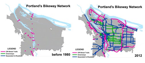
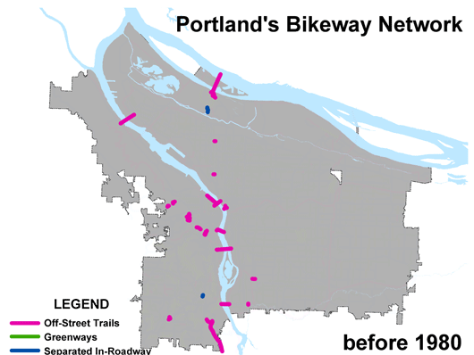
A few hours after it went up, Geller got in touch to share an updated set of images. The images not only provide more detail on what the various colors represent, but there are also many more of them. Geller has shared a year-by-year snapshot of how Portland’s bike network has evolved since “pre-1980” to all the projects currently funded past 2011.
In the new images, you’ll see three colors: Pink is for dedicated, off-street trails (also known as multi-use paths); green is for neighborhood greenways (also known as bike boulevards); and blue is for everything else (bike lanes, cycle tracks, buffered bike lanes).
Thanks to help from reader Spencer Boomhower (the same guy who did amazing animations showing an alternative vision for the Columbia River Crossing project and an explanation of the Idaho Stop Law), I can share these new images with you…
Check them out via GIF below (it starts automatically, so make sure you watch it all the way through):
And for your convenience, Spencer also uploaded it to Vimeo (it’s handy because you can stop it whenever you’d like):
Portland’s growing bike network from Spencer Boomhower on Vimeo.
A few things stand out for me while watching this:
- Our off-street path network has been stagnant for the past decade.
- From before 1980 to 1995, bikeways trickled in (about 114 total miles built*), then there was a big boom between 1996 and 2002 (when we added 139 miles during what some might consider the Mia Birk era).
- Between 2003 and 2009, we added only about 3.5 miles of new “separated in roadway” facilities (bike lanes and the like) per year.
- After 2009, the vast majority of additional bikeway miles has come in the form of neighborhood greenways.
- Despite the boom in bikeways in the 1990s, bike ridership in Portland didn’t really spike until 2005. Why? Perhaps it’s a sign that beyond just the physical infrastructure, culture plays a large role in getting people on bikes.
- *For reference, we have about 307 bikeway miles as of 2011.
For the numbers behind some of the data represented in these graphics, see this chart from PBOT: Bicycle Traffic across Four Main Portland Bicycle Bridges Juxtaposed with Bikeway Miles (JPEG opens in new window).
Geller has also shared some interested charts and stats on how bike ridership in Portland relates to U.S. Census tracts. I’ll put that together for a post soon.
")


Thanks for reading.
BikePortland has served this community with independent community journalism since 2005. We rely on subscriptions from readers like you to survive. Your financial support is vital in keeping this valuable resource alive and well.
Please subscribe today to strengthen and expand our work.
Thanks for passing this along. Stats are one thing, but a good graphic really does provide the big picture of what is, from my central Illinois perspective, a huge success story.
“Despite the boom in bikeways in the 1990s, bike ridership in Portland didn’t really spike until 2005. Why?”
I would have to think gas prices played a pretty big role in that. 2005 was the first time we really saw prices go over $3/gallon.
http://www.GasBuddy.com/gb_retail_price_chart.aspx?city1=USA Average&city2=&city3=&crude=n&tme=96&units=us
I think the collective dimension shouldn’t be overlooked. Once enough people bike, joining them is, for some people, easier than being the vanguard.
This is a huge deal, actually. Just the other day my wife and I were biking down SE Stark St, and I noticed there were about 12 of us cyclists vs 2 cars on the street. And I noticed that since we totally outnumbered the cars, the vehicle drivers were very non-aggressive, even for the time of day.
Good guess, and I think the factors outlined in Malcolm Gladwell’s book “The Tipping Point” were in full force as well.
if you change the chart to Portland you get a much different graph…
and I don’t remember seeing any dip in prices in the last month… although it’s less than a gallon to fill up the scooter every hundred miles so I rarely pay attention to the price of gas…
Two things that may be relevant:
1. In 2005, PBOT started their large-scale SmartTrips program. Since then, they’ve systematically reached the entire city with a friendly, successful campaign to help people bike (and walk & take transit) more often. It’s easy to forget about the importance of outreach and education when you’re just looking at bikeway miles on maps.
2. IMHO, I would characterize the recent focus on Neighborhood Greenways as an attempt to balance out a system that, in the past, relied too heavily on bike lanes on busier streets. I would warn other communities that want to emulate Portland’s success that you need a well balanced network that includes shared use paths, bike lanes/cycle tracks, AND bike boulevards/neighborhood greenways in order to achieve maximum mode shift. And as much as possible, I’d encourage people to develop redundant networks that allow people to select from a range of facility types for any trip. For example, if I want to commute fast I might take the Naito Parkway bike lane, but if I’m dooling around with my kid, I might take the Waterfront pathway; this is the hallmark of a resilient and attractive system.
Naito Parkway isn’t always the great option to “commute fast”. I typically make better time on the Waterfront pathway, because the lights on Naito are not timed for bike speeds and have long cycle times. (and I don’t ride Waterfront all that fast, either)
Good points.
Just over the past 2 weeks I have convinced 3 of my coworkers @Portland State, who have never bike commuted, to start bike commuting. So I think that everyone can give a little “friendly peer pressure” to help do their part!
I noticed that we’re all using cursive here in this conversation.
Which reminds me, is there somewhere those of us who don’t know html can go to learn a few tricks helpful in writing our comments, like italics, bold face, etc.?
In my experience, bold and italics are 90% of the html you’ll want to use in comment threads. You just need to put these short tags on either side of the text you want to format:
Bold your bold text
Italics your italic text
Remove the spaces and your tags will disappear and the text will be formatted:
Bold
Italics
Oops, I guess spaces don’t help. Try this:
your bold text
your italic text
Remove the dashes.
Thanks, Elliot.
I can see the hypertext (if that is the correct term) in the e-mailed version of your comment.
Looks like there’s an extra <em> tag on the second-to-last paragraph of the article that’s causing the italics. I included a closing tag for it in this post…donno if that will work or not.
Here’s some help with the limited HTML used by many blogs:
http://support.google.com/blogger/bin/answer.py?hl=en&answer=42069
The data strains for credibility if all of the city’s bridges (excluding I405) are counted as having “off-street trails” for the last 30+ years. If we’re counting sidewalks, let’s just paint the whole city magenta and declare victory.
And once again I’ll quickly flog my dead horse about Portland’s actual off-street trails being too few and too narrow. Minneapolis absolutely wins there.
Because the sidepaths on bridges don’t cross driveways, they are fundamentally different (from a safety and flow perspective) than sidewalks. They can be perfectly reasonable bikeways as long as they are adequate in terms of width and ingress/egress.
To your point, I think a lot of the bridges have had adequate bike facilities for most the last 30 years, with notable exceptions. The Ross Island Bridge, for example, should not be shown in magenta prior to the 2001 renovation which greatly widened its sidepath. Previously it was VERY narrow, and not something I’d want to ride on right next to all the truck and bus traffic — let alone, heaven forbid, meet another bicyclist or a pedestrian while crossing it. IIRC it was barely there, and narrower than the current inadequate path on the Sellwood Bridge.
You are absolutely right that Mpls absolutely embarrasses Portland when it comes to MUPs. And maybe it isn’t just Minneapolis: a few years ago I had a coworker who had just moved here from Boulder/Denver, and he kept saying “where are all the bike paths I thought Portland was supposed to have?”
Off street path over St. John’s bridge? makes me wonder how many other parts of the map are false.
Why does it seems to me like there were a ton more off street paths than are shown in the 1980 map.
Upon checking my facts I found that about 1/3 of Portland has been annexed after 1980-1990. So we are not really comparing apples to apples.
I also discovered that, oops, I didn’t really live in Portland at that time. We had a Portland mailing address but were not actually inside the city limits.
It seems to me that connectivity and comfort may be big factors in why biking took off after 2005. If you look at what I’ll call the “high-comfort” network, which includes greenways and shared-use paths (Green and pink on the map), there wasn’t much of a connected network until the early 2000s. Gaps in comfortable bike facilities mean that the majority of cyclists, who do not fall into the “confident” category, cannot get to where they are going without having to use streets that make them uncomfortable, effectively preventing them from making those trips.
The more places you link to the “high-comfort” network, the more biking will explode in those places. In places like downtown and along busy streets, where Greenways and shared-use paths are not really possible, cycle tracks can be used to extend the “high-comfort” network, and allow people to reach their destinations without having to use less comfortable bike lanes adjacent to high-speed traffic.
This is really awesome!
My only gripe is that it doesn’t really reflect the *quality* of the bike facilities. Of course, I don’t really know how a map would go about achieving this.
Many bikelanes in our fair city are incredibly narrow, have their markings & stripings completely worn away, & are chok-full of potholes. Many of the neighborhood greenways are mediocre facilities at best, with too much motor traffic, and aren’t super pleasant to ride on unless you are a pretty confident rider.
Don’t forget folks, it’s not just about quantity. Quality also counts for a great deal! Platinum all the way! Not say, uh, tin!
Thanks, Spencer and Jonathan. The animation and video are excellent visualizations. While Portland isn’t a perfect city for bicyclists or pedestrians (yet), I appreciate being reminded of how far we’ve come. In 1980, when I moved to Portland from Anchorage, it was difficult for me to commute by bicycle from my apartment to my job downtown. The distance was less than 1.5 miles. (My apartment building was/is located across from the then Washington-Monroe High School.) To avoid the bicycling commute hassle, I usually just walked or took the bus. Not bad options, they were just a little slower.
Side note: In 1983, I returned to live in Alaska for a few years. Having recently lived in Portland, Corvallis and Eugene, I had reservations about living in Anchorage again because of the auto-centric culture. However, to the credit of the mayor (Tony Knowles) and many citizen volunteers, I returned to find an extensive network of paved and unpaved trails throughout the city. Today, although Anchorage is still very automobile-oriented, the city’s trail system extends hundreds of miles. If you visit Anchorage, regardless of the season, I encourage you to check out their trails and parks.