
Welcome to the first of a new feature on BikePortland: a brief look at the life or work of an extraordinary local person.

(Photo by J.Maus)
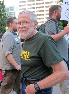
When Jim Howell was 37, he organized the first demonstrations that eventually turned Harbor Drive into Waterfront Park. At 40, working as an independent architect, he drew up the design for Northeast Portland’s Woodlawn Park. At 41, he sat on the citizens’ committee that recommended Portland’s first MAX line. At 48, while working for TriMet, he engineered the west-side bus node now known as Beaverton Transit Center. At 51, he co-founded a private van service between Portland and the Oregon coast, a predecessor to today’s Wave bus. At 77, he co-created the plan that became the most prominent alternative to the Columbia River Crossing.
Now, two months before his 80th birthday, Howell has designed his first transportation concept that puts bikes front and center.
It’s a double-decker rail/bike corridor that would, Howell says, dramatically improve transportation through Portland’s central east side while literally creating a car-free second-story commercial district out of thin air.
And as usual, he’s got the renderings to explain it, handbuilt in PowerPoint on his Windows Vista laptop.
“Are you familiar with the High Line in New York?” Howell asks in his soft, thin voice. “We could call this our own High Line.”
“The idea here is to combine light rail and an express bikeway… My off-the-cuff guess is that you’re looking at a $200 million project, which is roughly half what they want to spend to add another damn lane to the freeway.”
— Jim Howell
In an interview Thursday in the kitchen of the Beaumont house he bought for $8,000 after returning from Army service in postwar Germany, Howell sipped Hefeweizen and explained the details of his latest audacious plan.
“I call it ISE-BREW,” he said. He chuckled. “Inner SouthEast Bike-Rail ExpressWay, you see?”
It’s a play on ISTEA, the 1991 federal transportation bill.
Howell likes acronyms. A lot. In 1971, he coined one that stuck: Sensible Transportation Options for People, the group Ron Buel formed with him, Betty Merten and a few friends. Over the next five years, they stopped the proposed Mount Hood Freeway from bulldozing Division Street.
Howell’s new concept isn’t so different: instead of widening Interstate 5 through the Rose Quarter for $400 million, it’d find cheaper ways to move people quickly through the area.
“The idea here is to combine light rail and an express bikeway,” Howell said. “From the Springwater Corridor, it’ll take you directly, fast, right up to the Rose Quarter.”
The most interesting trick: for 12 blocks, from Stark to Clay streets, Howell’s light rail line and bikeway would run directly above the Union Pacific Railroad tracks.

“These are just conceptual – nothing engineering about them,” Howell said as he flipped through the glossy renderings he’s prepared. “But I know they can be done.”
A few years ago, when TriMet was making plans for its Orange Line, Howell conspired with a friend at TriMet to survey whether a raised platform like this could thread through the Rose Quarter’s bramble of overpasses. It could.
At its north end, the bikeway and light rail line would connect directly to Wheeler Avenue, then run between Interstate 5 and the railroad line until just north of the Burnside Bridge:

At the rapidly developing Burnside Bridgehead, ramps and maybe elevators would connect the bikeway and a new Burnside Street MAX stop to the bridge and bus lines above:

South of the Burnside, the bike path and light rail would climb at a 3 percent grade to above the Morrison and Belmont viaducts, then descend again to the level of the Hawthorne-Madison viaducts and finally connect to the new Orange Line light rail bridge.


The adjoining buildings, Howell said, would then be able to open storefronts that open onto the new bike-rail path and the bridges themselves.
The result would be a connected loop of criscrossing rail, bus and bikeways that Howell says could move at least 2,000 people an hour — about as many as a freeway lane can carry.

“My off-the-cuff guess is that you’re looking at a $200 million project, which is roughly half what they want to spend to add another damn lane to the freeway,” Howell said. “It will reduce the traffic demand on I-5, MLK and Grand and it would provide a true north-south, traffic-free cycle track. And it would also provide a north-south rapid transit line from Vancouver south to Tualatin, which is sorely needed because there is no south leg to that. And it provides far better connections between MAX and buses. The heaviest ridership in the system is on the east side.”
I asked Howell how this would be different from the nearby Eastbank Esplanade, along the river.
(Photo by M.Andersen)
“Its purpose is not recreation, just like the purpose of the freeway is not recreation — this is a bicycle freeway,” he said. “The Esplanade suffers from its popularity. It’s such a great thing that there are so many people using it in their wheelchairs, their strollers, their kids. Think back in the 60s when we started putting freeways in because roadways got clogged up. You might say this is kind of a parallel situation. It becomes so popular that we need an alternative.”
Howell said he hasn’t been able to ride a bike himself for 40 years, when he developed chest pains during a long ride and wound up in bypass surgery. Today he gets around by transit, car and foot. He moves with a stoop, his shoulders pushed forward by years of leaning over sketches, keyboards and committee tables.
Howell said he spends maybe 10 hours a week on his transportation advocacy. It’s been volunteer-only since he left his TriMet job in 1985, sick of working inside a bureaucracy. His only official title these days, which he can’t remember without looking at his business card, is “director, strategic planning” for AORTA, a volunteer citizens’ rail and transit advocacy group.
“My wife thinks I’m crazy, and my kids,” he said.
It hasn’t stopped him.
“There’s always a project,” Howell said quietly, finishing his beer. “You can’t be too impatient, because it takes 10 years to get anything done. That’s been my theory, anyway.”
Corrections 11/25: An earlier version of this post inaccurately described the line’s proposed crossing of the Morrison Bridge and the quadrant of Woodlawn Park.


Thanks for reading.
BikePortland has served this community with independent community journalism since 2005. We rely on subscriptions from readers like you to survive. Your financial support is vital in keeping this valuable resource alive and well.
Please subscribe today to strengthen and expand our work.
so how do we get the money away from ODOT?
I doubt any one funding source would cover this. State,Federal, local and regional monies combined over a fairly long term would make it happen, incrementally. The City would have to meld the features of the various district master plans with trimets and metros vision for transportation and economic goals for the central eastside as well as the city and region as a whole.
Not to suggest Howells suggestion is faulty. I see it as halfway there..rail being undergrounded is a great idea for the city..but would it work for the RR? I like light rail being undergrounded too.. turning it into a real subway , not only in SE, but downtown too.
It’s breathtaking how much Portland owes to this man. I had no idea. Thank you for this fine profile, and Jim, if you’re reading this, thank YOU for your amazing contribution to my home town.
Looks awesome! Would be a great way to add transit and commercial space to the east side without taking way the industrial and recteational space there.
That being said, I have concerns. What are the laws regarding “air space” over privately owned railroad tracks? Can we really build an elevated double tracked light rail line plus cycle path for just $200 million?
And what about the interaction between pedestrians and bicycles? If they have to cross two bike lanes to get on the light rail, that could cause accidents. Would it have traffic signals?
Still seems like an amazing idea though.
Anyone that rides on the Springwater (which this is going to connect to) or any MUP path for that matter usually has a pretty good understanding that there are going to be pedestrians. I have yet to hear about a high number of ped/bike collisions on the 205 path since Max has been there.
Yeah, I pushed Howell about the space too. He says there are 60 feet between the buildings. Of that, you need 24 for two light rail tracks. The two-way bike path would be 16 feet (enough for passing and riding side by side). Assuming you can put your infrastructure right up against the buildings, that leaves 20 feet for sidewalk space and (at some points) shelters. This might force some mixing at the shelters.
As for the railroad air rights, Howell says they’re not an issue because his understanding is that in this case, it’s actually city land that the railroad has been given indefinite right to use. See my reply to Todd Hudson below.
The RR will still want 30-40 ft of vertical clearance for tall rail cars.
And I’m sure UPRR will instantly say no!
Howell thought they would, too, but he said a UP representative was surprisingly positive.
I didn’t want to bog down the story with these details, but there are a few things in this for UP:
– Because you could go up and over the track, the city could plausibly remove some of the at-grade street crossings of their track. That’s a safety hazard and a delay risk for UP.
– It’d make it easier for them to add a third set of tracks, which is required for long-term passenger rail plans already.
– It’d invest the public further in preserving this right-of-way … which, unlike with most other tracks, Howell says UP doesn’t actually own. I haven’t been able to verify this, but he says it’s his understanding that the land is actually owned by the city (it’s technically 1st Avenue), while UP has an indefinite right to use it.
Another issue looming here is the fact that the central eastside is facing a lot of economic pressure to go residential. For this to happen, landlords would presumably need the trains to stop blowing their horns, and would pursue a quiet zone like the one in the Pearl. By law, a quiet zone requires a bunch of new stuff at all the rail crossings, which is expensive (though not UP’s responsibility). Reducing the number of rail crossings cuts those costs sharply.
just make sure we get the cement road for npGreenway in exchange for any improvements to UPRR tracks.
Yes, please!!
Great idea, if you are focussed on the inner east side. It increases access while creating three demensional pedestrian space. It would also have the needed side effect of an earthquake ready mass transit connection. No one likes to talk about it, but in a major quake the Steel is a goner.
I want to buy this man a beer.
I’d trade the eastside freeway for this any day.
“South of the Burnside, the bike path and light rail would climb at a 3 percent grade to the level of the Morrison Bridge and Hawthorne-Madison viaducts, then descend again to connect to the new Orange Line light rail bridge.”
Minor clarification, Michael – Jim’s diagrams indicate that the the guideway would cross above the grade of the Morrison Bridge viaducts – due to conflicts with I-5 ramp traffic, I presume. It would, however, cross the Hawthorne Bridge viaducts at-grade.
Right you are. Corrected and thanks.
Fantastic idea. I’d love to see it happen. In the interim can we turn Water Avenue into a cycle track, and connect it along the UP tracks to the Steel cycling bridge?
This man is a local treasure. I can’t think of anyone else who is more deserving of having their name on the new Trimet Bridge.
Thank you, Bike Portland, for running this story. I have only been in Portland for a few years and love hearing about how the City got to where it is now.
How’s about over the 405 as well…..
As much as I want to like this idea, I just don’t get it. For far less money, we could have a multi-use path bridge over I-84 and a great bikeway on SE 7th. We could also afford a fully grade-separated Sullivan’s Gulch Trail, improvements to the North Greenway Trail, and many more bike improvements.
I’m not sure it makes sense to add a light rail line through here prior to the I-5 mess being resolved.
No. Please. The reason I live on the Yellow Line is because it goes to PSU.
It could still have PSU Service, it could provide as a split route type train. ie a north south through train and a downtown train. One could be called the Yellow Line and go where it goes now, and one could be a through train and be called the Orange Line or something … easy fixes. As for going downtown, Trimet is also a big fan of keeping trains going that way because PSU is their busiest stop in town ( last I checked ).
Really great profile. I didn’t know the extent of Jim’s work outside of his work on the Mt Hood Freeway and Waterfront Park (and the Common Sense Alternative of course), and a vague sense that this city owes much of its livability to him.
Just imagine SE Division, SE Clinton and all the blocks in between them turned into a gigantic trench with a freeway running down it, like I-5 through North Portland. What a loss that would have been. That plan was scrapped thanks in part to Jim and his friends. Something should be named after those guys.
This new “Portland’s own High Line” idea is really compelling. This is the kind of transportation infrastructure that injects life into the heart of a city. (As opposed to, say, freeway infrastructure that eats away at the value of anything that surrounds it, largely for the sake of providing sometimes-speedy access to the urban core to the most far-flung, sprawling parts of the region.) It’s worth building. Time to get that ten-year process rolling!
> That plan was scrapped thanks in part to Jim and his friends. Something should be named after those guys.
“The Howell High Line”.
Wouldn’t it make more sense to trench the rail line between Stark and Clay? This would remove all of the at-grade crossings and eliminate all of the horn-blowing in the area. The 3-track trench could be capped, and a MUP or LRT along the line would just run at grade.
> Wouldn’t it make more sense to trench the rail line between Stark and Clay?
Note that to put the rail low enough, you have to start descending quite a ways back. In an ideal world, the rail would drop down much further south so the grid of streets could be maintained.
There is plenty of room between the Steel Bridge and Stark for the tracks to descend. South of Clay, it would likely take until at least SE 8th Ave for the tracks to ascend back up. This section has MAX line crossings anyway, so little would be gained by extending the trench.
Just realize that a steep grade for a railroad is 1%. Thats means it takes 1000 ft to rise/drop 10ft. They may So it’s easily going to take 4000 ft at each end if you want to drop the railroad 40 ft. The Steel bridge to Stark is a little over 3000 ft. so that limits it to a 30ft drop. And that may also put it below the water table. The railroad would possibly want a lesser grade to the slope as at 1% you need twice as much power to move the same number of cars, and they may not want to tie up extra locomotives for that.
This looks appealing only if you ignore the vertical aspects of the alignment. Clearance above a railroad needs to be at least 24 feet with about another 15 for the structure supporting the MAX/cycle track above. You’re talking about a path and MAX line about 40 feet above the RR tracks. That’s third floor, not second floor access.
Above the Morrison ramps and various other roadways you need clearances of at least 17 feet plus structure depth of at least 10 feet. Morrison is already high above Water Avenue. The Howell proposal would be above that – maybe 60 to 70 above the surface. I think the concept needs a lot more work.
And another issue not addressed here is the ventilation the locomotives would need to operate. A typical diesel-electric has a 4400hp turbocharged diesel (roughly a 12,000 cu.in engine). And most trains I’ve seen pass through there have 3 to 4 locomotives pulling them. Theres a lot of exhaust coming out of each one of those so good airflow would be necessary for the locomotives and for the people above them.
Not to mention you cannot simply attach LRT platforms to the existing buildings – the vibration would tear the buildings apart. You also can’t sink support columns right next to the existing railroad tracks – federal law stipulates there can’t be structures within a rail right-of-way.
This is a very fascinating design, but for the most part, it’s a pipe dream.
Woodlawn Park is in NE Portland
Yup. Thanks. Fixed.
Fantastic vision.
As long as it still works when we finally get around to demolishing the Marquam Bridge and I-5 from there up to the Rose Quarter (with the current I-405 renamed to I-5), I’m all for it.
Hmm, my initial reaction is that wow, this is great, it would mean that two LRT alignments would serve Interstate Avenue — the one headed directly downtown, and the new one that would continue south along the eastside. This would get headways on Interstate down to 7.5 minutes from 15, which would be wonderful!
However, I do remember that urbanists have been complaining for years about skybridges, the complaint being that putting pedestrians above the street removes them from participating in street-level activity. This removes the potential to add their eyes on the street, activate ground-floor retail, etc… so, it would seem preferable for all of this to shift down, i.e. bury the railroad in a cut-and-cover box (preferably electrifying it in the process), then put all of this on a new (car-free?) 1st Avenue at ground level.
And yes — remove I-5 from the east side, such as to add that additional full block of real estate development potential to the station areas that could be activated by this new alignment….