Bike Score (the same folks that created the more widely-known Walk Score) have ranked Portland as the #1 “most bikeable” large city in the United States. In their rankings, which were released today to coincide with National Bike to Work Week, Portland squeaked into first place, just 0.3 points ahead of San Francisco. Denver, Philadelphia, and Boston rounded out the top five spots.
When these same rankings came out last year, Portland was #2 behind Minneapolis, but this year cities above 500,000 people competed against each other while smaller cities were put on a separate list.
And for the first time ever, the Bike Score team also scored individual neighborhoods. In Portland, the Lloyd neighborhood was found to be the most bikeable, receiving a 98.2 out of 100 points. The Bike Score methodology ranks locations based on four equally weighted components: Bike lanes, hills, destinations and road connectivity, bike commuting mode share.
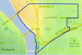
ike Score found to be the most bikeable in Portland.
We got an early peek at the neighborhood rankings and I’ve pulled out the top 20 Portland neighborhoods:
- Lloyd – 98.2 (pop. 1,354)
- Old Town/Chinatown – 97.9 (pop. 3,656)
- Pearl District – 96.8 (pop. 6,053)
- Hollywood – 95.3 (pop. 1,339)
- Sullivan’s Gulch – 94.9 (pop. 3,193)
- Buckman – 94.7 (pop. 8,472)
- Eliot – 92.8 (pop. 3,573)
- Arbor Lodge – 92.8 (pop. 6,126)
- Hosford-Abernethy – 92.0 (pop. 7,371)
- Downtown – 91.9 (pop. 12,675)
- Boise – 90.6 (pop. 3,269)
- Kerns – 90.1 (pop. 5,301)
- Humboldt – 89.9 (pop. 5,156)
- Laurelhurst – 89.6 (pop. 4,721)
- Richmond – 89.5 (pop. 11,659)
- Irvington – 88.6 (pop. 6,655)
- Kenton – 88.1 (pop. 7,228)
- Sunnyside – 88.0 (pop. 7,233)
- Overlook – 86.7 (pop. 6,114)
- Piedmont – 86.4 (pop. 7,018)
These Portland neighborhood results are surprising. Lloyd is not the first place we think of when they hear the phrase “bike-friendly.” In fact, “avoid the Lloyd” is something of a rallying cry among locals frustrated with that area’s bikeway connectivity. However, in recent years additions to the bike network in the Lloyd area might be changing that. In the past few years we’ve seen the new, wide (and in some places protected) bike lane on NE 7th adjacent to the new streetcar line, the improvements on and around the NE 12th Avenue overcrossing, and of course the protected bike lane on NE Multnomah.
That being said, it’s impossible for any ranking system like this to include subjective information about riding in a particular area. Numbers alone cannot quantify how a place feels while riding through nor can they measure stress levels. It’s also important to note that Portland’s network of bike boulevards/neighborhood greenways don’t impact the rankings because they are not captures as “bike lanes” or bike infrastructure.
Bike Score also announced today that their data is available in 100 U.S. cities. Bike Score uses their data primarily as a way to encourage and inform the real estate industry about how biking and walking trends impact housing values. Learn more at WalkScore.com.



Thanks for reading.
BikePortland has served this community with independent community journalism since 2005. We rely on subscriptions from readers like you to survive. Your financial support is vital in keeping this valuable resource alive and well.
Please subscribe today to strengthen and expand our work.
The ranking itself probably seems a little off because the official borders of neighborhoods is somewhat arbitrary. I’d be more interested to see where the ‘hotspots’ are. That’s where the magic happens.
The light yellow band shows a need for a N-S connector in the 20s-30s vicinity.
NE, SE, North, and the Pearl—only four of the six quadrants get any representation (yes, it’s time to call East Portland a quadrant, they have their own Parkways)…
I pretty much see: NE, NE, NE. Can definitely see where Portland’s priorities are!
thanks for clarifying that although it’s ranked high on BikeScore it’s ranked low by locals… there’s still too much crazy car traffic for it to be pleasant… but yes, it’s getting better…
I also wouldn’t qualify streetcar tracks adjacent to a bike lane as an improvement… I’d call it a detriment to cycling access… streetcar tracks generally slow down bike traffic and completely scare some people away… I saw many people crash on streetcar tracks during the MMR this last weekend…
Honestly- their metrics seem totally useless to me. How can low-traffic neighborhood streets not be marked green? the idea of being near a marked bike lane as making you a hotspot is weak in my opinion
If the algorithm thinks it’s bike friendly, maybe reality needs to change to catch up with the analysis…
sepahu said…
“The light yellow band shows a need for a N-S connector in the 20s-30s vicinity.”
Quoted for truth. There’s a real dearth of solid, enjoyable, relatively direct north-south routes in Portland in general. I was about to type “on the east side,” but really, they’re pretty bad everywhere; going from south to north through downtown is a pain too, and there’s way fewer good bike crossings across Banfield than I would like.
I think it’s great that Walk Score is grading neighborhoods on bikeability, and I look forward to them perfecting their methodology over time. Their walking ratings have improved over time, and I’m sure the biking ratings will, too. That bike boulevards — in my opinion by far the best and most enjoyable way to get around Portland on bike — aren’t factored into the scores yet indicates that they have a ways to go.
That said, as someone who kind of lives at the intersection of Lloyd, Irvington, and Sullivan’s Gulch, I’ll speak up for my neighborhood a bit. Between the new Multnomah lane (and hell, even the old one was at least decent), the dual lanes on Broadway and Weidler, Tillamook, the 12th Avenue crossing across Banfield, the Broadway Bridge and its quick downtown access, and the decent retail density of the neighborhood and neighborhoods adjacent, I think it’s a pretty good part of town to live in if you’re a cyclist. There’s hardly a destination in central Portland that takes me more than 20 minutes to get to. It’s not necessarily the hippest neighborhood, but I find it pretty damn livable.
Hear, hear. Any I-84 crossing that doesn’t have freeway ramps is a crucial part of the low-stress bike network. 12th, 21st, 28th, 47th, 53rd, 74th — all of these should connect seamlessly to good bike facilities, but they generally don’t. 53rd and 74th are OK.
Yep. 12th is better than it *was*, but if you’re trip extends to or from further north of the I-84 overcrossing, then the connection is non-intuitive at best. At least the folks who re-did the Lloyd Cinema parking lot were gracious enough to install a lovely raised cycle path running diagonally right through :^)
I did not know that! Thanks.
It’s a sidewalk, not a dedicated bike path, but it works okay…
Yup, I was being facetious ;^)
This is kinda funny since getting from the Steel to the Broadway bridge is no easy task on the East side. In fact, that entire area is very very bike unfriendly.
As a Richmond / Sunnyside resident, I say the fix is in – clearly the Man is keeping my neighborhood down. I’ll be picketing the Bike Score offices later this week, demanding a higher score, who’s with me?
Hey, at least they made the list. My beloved Montavilla neighborhood is nowhere to be found.
Maybe there aren’t enough hills? ;-P
not so fast, dan.
I’m a Sunnyside resident too, but wouldn’t you know, Lloyd has the second-lowest car ownership rates of any neighborhood in the city. I wonder… hm… if that could have anything to do with this? If Sunnyside got it’s car ownership rates down that low we might be a contender. Ha.
Census tract 24.02 includes everything from I-84 to Thompson and from 9th to 20th (the Eastern half of Lloyd but probably a higher share of it’s population). 22% of homeowners and 34% of renters in that census tract did not own a car in 2000, for a total rate of carfree households of 31%. I’d need to dig up the 2010 numbers but my suspicion would be they’d be a tad higher.
Yep, I’d rather ride Sunnyside’s quieter roads than the Pearl or Old Town/Chinatown! Also, totally agree with Granpa that Sellwood is terribly omitted from the list.
Meanwhile, the Sellwood neighborhood, which was not even in the top 20, has a separate, multi-use path running through a wildlife refuge all the way into down town. The neighborhood generally has low volume, slow traffic and grid system street layout making for easy low stress riding. Although Sellwood does not have sharrows, sharrows only validate conditions that already exist, and Sellwood riders and drivers share the road constantly. AND the grades in that neighborhood are gentle, And there are no streetcar tracks to snag wheels. Just say’n that the methodology may not be considering what constitutes a quality bike riding experience.
Isn’t SE Spokane, the first modern neighborhood greenway, in Sellwood and sharrowed up?
Oh yea, they have been there so long that I don’t even notice them, along with the traffic calming and vehicle restrictions.
The neighborhood ranks show that the standards are set way too low compared to international standards. No way that the Pearl would rank above a 54 (Hamburg / Paris) on the Copenhagenize index: http://www.copenhagenize.com/2013/04/copenhagenize-index-2013-bicycle.html
I wonder if they deduct points for streetcar or Max tracks. Probably not. It sounds like the algorithm is a bit “off”.
The BikeScore methodology may be a bit more balanced, but I’ve noticed that the WalkScore figures go up anywhere you’re near a big shopping center, and even more so around a huge mall.
So they’re rewarding areas where lots of retail amenities are within easy walking (or biking) distance, even when the area isn’t that easy to get around by foot or bike.
Also (Lloyd District being an exception), areas around big malls tend to be pretty sparse in terms of housing options, so it can be hard to take advantage of the high Scores there.
If you took Sunnyside out of the mix, you could make an argument that the list is upside down.
Downtown beats out Irvington. Right.
Why would ya take Sunnyside out of the mix? The neighborhood is narrow and has great local destinations. Access to other areas is quite good and getting better w/ the 50s going in. N/S access suffers as much as any SE neighborhood. It might not be #2, but it’s certainly not #18…
Wow. I would not say the Lloyd district was all that bike-friendly at all. I-84 cuts right through it, and the only options for crossing it are NE Grand Ave (no bike access, aka cr*p); NE MLK (no bike access, aka cr*p); or NE 12th (too scared to ride on road with traffic southbound here).
Am I the only person that thinks this area is CRYING OUT for a bike/ped bridge at NE 7th, across I-84. The lack of connectivity in this area is frightening.
Oh, everyone who rides S/N through Lloyd wants a 7th Ave. bike/ped overcrossing. 12th got a major improvement , considering what it started like, but it feels like an interim fix. Anyone wants to join me in advocating for 7th, please let me know.
mh
ha, what a joke! go to the site and you can see that they weight bike lanes, but apparently only MUPs and cycle tracks. Cully with it’s new “cycletrack to nowhere” is bright green when you click on the bike lanes tab. Same with the airport.
too bad there’s no way to get any actual BikeScore numbers from their web site… from the BikeScore map all you can get is a WalkScore… useless…
Wow. I don’t know about this bikescore business. I think there is a fundamental problem with the scores, which is accounted for by the role “Walk Score” plays in neighborhoods. The idea of a walk score is to grade the ability to walk to amenities WITHIN an area. Can you walk to the grocery? Can you walk to restaurants? Biking, however, as a form of TRANSPORTATION has to be about connectivity. If the bike score is only about the number of bike lanes (with no understanding where they go–or don’t) then bike scores will not be all that useful. I live in Sunnyside and I think directness should be considered. Getting *through* the Lloyd is very confusing (streets stop, run into the mall, highways, max tracks….) and clearly there are some serious problems with the algorithm. Sellwood probably suffers because the Springwater is down the hill from the residential areas. Of course we don’t think much of that hill, but compared to Lloyd, Pearl, Old Town…even the hill at 30th and Salmon must seem daunting to the computer.
Ha. Is this is a joke?
Don’t tell Weidler from the 1-84 off-ramp all the way up to the mall.. which is by far the worst/most dangerous stretch of pavement that you can ride over in the entire city.
Oops… meant the 1-5 off ramp.