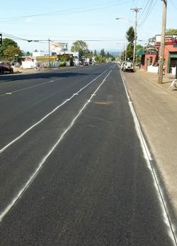
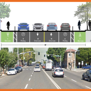
(brown area is parking lane).
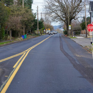
(Photo: PBOT)
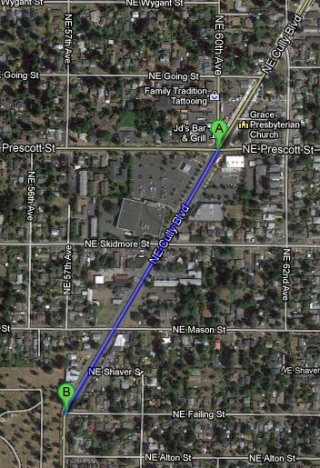
The Bureau of Transportation (PBOT) is taking advantage of a paving project to improve bicycle access on a major street in northeast Portland. On Friday, PBOT announced a new buffered bike lane is coming to NE Cully Blvd between Prescott and Failing streets.
This 1/3 mile stretch of road is being repaved and PBOT is taking the opportunity to re-stripe the road in order to make the bicycle lane wider and more comfortable. PBOT will add a three-foot wide buffer to the existing five-foot wide bike lanes. The start of this project is just south of the existing physically separated cycle-tracks on Cully Blvd which were completed nearly two years ago. According to PBOT, when coupled with the cycle-track, “the buffered bike lane will provide people riding bicycles with nearly one mile of separated bikeway.”
This new buffered lane will also help smooth out the jarring emotional transition from the cycle-track to a standard, door-zone bike lane. It’s important to note that there are two schools nearby: Harvey Scott and Rigler.
To get the space for the wider bike lane, PBOT reduced the center turn lane from 15 to 10 feet and narrowed the two standard vehicle lanes (total road width is 66-feet).
As with many small-scale bikeway improvements throughout Portland over the years, the money to fund this re-striping — a whopping (sarcasm) $4,000 — comes from PBOT’s “Missing Links” program. This program is funded to the tune of just $50,000 per year; but its strategic investments add up to make significant enhancements to our bike network. Since 2000, the Missing Links program has developed over 40 miles of bikeways throughout the city. The program specifically focuses on creating and improving bikeways in conjunction with other projects (like paving).
With Mayor Hales putting a greater focus on paving and maintenance, it makes it more important than ever to have PBOT’s planners working closely with maintenance and paving crews. We can’t afford not to make these types of improvements wherever — and whenever — possible.
Read more from PBOT’s Active Transportation division.


Thanks for reading.
BikePortland has served this community with independent community journalism since 2005. We rely on subscriptions from readers like you to survive. Your financial support is vital in keeping this valuable resource alive and well.
Please subscribe today to strengthen and expand our work.
Thanks for sharing this great news, Jonathan! This stretch of NE Cully was perfect for such a project, and I love that it’s just south of the amazing cycle track (of which which we need many more!)
Gah!
The wall of cars blocking view of cyclists prior to intersections and the bizarre curves are a complete fail. It does make a fine sidewalk, however.
Fantastic. I’ve seen riders cruising along in the cycle track, and then transition on the sidewalk south of Prescott presumably because the bike lane wasn’t comfortable enough. I wonder if the buffered bike lane will be attractive enough for those riders to use.
Want to stop sidewalk riding? Cycle tracks are one answer.
I love that they are doing this, I just noticed it yesterday! I am sad that it stops short of the curve in the road where cars always cut into the bike lane… I also have come to dislike the cycle track down on cully because cars on cross streets don’t even think to stop until past the sidewalk, cycle track AND the street parking on the other side.. If I was not always aware of this and keeping an eye out, I probably would not be typing this right now.
“I also have come to dislike the cycle track down on cully because cars on cross streets don’t even think to stop until past the sidewalk, cycle track AND the street parking on the other side.. ”
On the original cycle track thread I was quite positive. Unfortunately, I have often seen motorists whip through the cycle track without any hesitation (both through traffic and right hook scenarios). If you read the original thread this is exactly what “are” predicted.
…as well. Not on my regular commute, although friends live out that way and I have ridden enough through there to know staying vigilant of vehicles merging from the east is prudent.
I have no skills in offering suggestions for improvement….but,..
I am not shy to take the lane going north (down hil), as I feel it is safer for me.
The downhill track headed north seems dangerous at the speeds I ride (25ish). I take the shoulder, as do others.
I love that this is happening. I wonder if there are any studies to show that a narrow painted buffer attracts additional cyclists to a given route, as compared to a physically separated facility.
I say “narrow” because I’ve got a Streetfilms image burned in my brain of a generously wide NYC painted buffer (PLUS parking separation), after seeing it in the latest Momentum Mag issue’s profile on Mark Gorton.
The replacement of cycle tracks with buffered bike lanes has been a huge success in Munich:
Munich mode share 1996: 6 %
Munich mode share 2012: 17%
Good reference, spare_wheel. What is the profile of those Munich buffered bike lanes? Wide buffer + narrow lane? The reverse? Equal wideth? Are the lanes themselves differentiated by color or grade? I wasn’t able to find info on the ‘net.
I couldn’t find any information about these results in Munich, either; I’m very curious about this! I looked at videos and pictures of cycles tracks from around the world, and they are ALWAYS much, much nicer, safer and more appealing than any bike lanes appear, at least to me. So I’m super curious to know why buffered bike lanes attracted (apparently) so much more bike traffic in Munich. We need to do whatever it takes to vastly increase the bike mode share in Portland–including suburban areas.
They are super wide 2-3 meter lanes separated by a big white line.
New bike lanes (you can see the old narrow cycle track in the back):
http://goo.gl/maps/itbXt
perm link
I’m not surprised that a wide bike lane is more popular than a door zone cycle track. Measuring in google maps, both the bike lane and the old cycle track are about 6.5 feet. Given only 6.5 feet to play with a bike lane wins, hands down.
also frequently blocked by trash cans, construction, parked cars, delivery vehicles, and wandering peds. 🙁
Wow, this (Munich location) looks no different from what we already have on N Williams. Wider bike lane, no painted buffer. I can’t fathom that this model is responsible for a big increase in the bicycle mode split.
If we shift the view just a couple blocks to the north or south, we see that the exposed un-buffered section lies in between sections to the north and south, where lanes are otherwise physically separated from auto traffic, either by grade, auto parking, planters, and in some cases by all of the above.
to the north: http://tinyurl.com/ctjxlc2
to the south: http://tinyurl.com/cmvruqb
Is there something published somewhere that describes the mode split improvement since 1996 and attempts to analyze/identify the supposed drivers of that change? I’m just after the source for your assertion that replacing physically separated bike facilities with unprotected bike lanes drove up the bike mode split.
I agree, Craig! Look at Alta’s “Cycle Tracks: Lessons Learned” PDF that’s referenced from this page: http://www.altaplanning.com/cycle+tracks.aspx. There’s nothing as enticing, beautiful, safe and urbane/sophisticated-looking as a well-made cycle track; In college, I road the incredible cycle track on University Ave. in Madison at least 2000 times, and I loved every second of it. I would go blocks out of my way just to use that cycle track.
Plus, the bike lanes in those shots of Munich look awful. I’m sorry, but there absolutely has to be some other explanation for the increase in cycling in Munich; that is the worst bike infrastructure I’ve ever seen in Europe–it’s exactly like ours!
Bike lanes, whether buffered or not, always put cyclists inches away from either a parked car (and an eventual dooring incident), a car about to pull out, or fast-moving cars. I just don’t see any possible way that bike lanes can ever be preferred by the overwhelming “interested but concerned” percentage of our population. Again, WE are the 2% who feel safe riding anywhere, but 98% of suburbanites won’t go for stripes painted inches from cars & trucks.
Look at the incredible transformation of Hornsby & Dunsmuir in Vancouver. Those cycle tracks are incredible! Even I was scared to use the bike lanes before, but anyone from 8 to 80 would feel comfortable riding in those amazing cycle tracks!
There’s another horrible thing about bike lanes: they fill up with debris like crazy! You actually *need* cars (how ironic) to help force all the debris to the very edge of the road; without them, the dirt, glass and other debris collects just beyond the cars’ tires–in, you guessed it, the bike lane! This is yet another of the dozens of reasons to have (at least several well-placed) concrete-separated corridors purely for cyclists.
correlation is not causation. many of those cycle tracks are older infrastructure that were present when mode share was in the single digits or low double digits. i think its naive to assume that infrastructure alone is sufficient.
the german cycling federation has been very critical of cycle tracks because they are often blocked and in bad repair. moreover, the federation conducted studies of german and dutch traffic data and found that cycletracks/paths were associated with a far higher rate of injury. this is, of course, controversial with the dutch fietsbarad arguing that the majority of cyclepath injuries involve non-motorist collisions.
i’d post links now but i am too busy.
Very cool! I’m not sure I ever made the connection that buffered bike lane = separated infrastructure. Seems a bit of a leap to me, but I’ll take it!
What’s missing is the connection north from here to the airport; this points right at the airport, but there is a big mess of nasty in the middle for bicyclists…
This is terrific, but I have a question about the process. Is there any way to know ahead of time what PBOT and other transportation organizations are going to do? I live very close to this project, and I’m very active in the neighborhood, and I had no idea that this was going to happen until the stripes appeared. Was there an opportunity for public input? Jonathan, did you know ahead of time?
Hi William,
No. I didn’t know about this until I read about it on PBOT’s website. But I don’t expect there to be much warning because I realize these are very opportunistic projects. Often, the Active Transportation folks within PBOT have little time to react themselves… It’s a matter of timing and coordinating planning with the pavement and maintenance crews. That being said, I wonder if there’s a more formal way these things can be planned for. Like one more box to check on the paving project work order that asks.. “Have you asked Active Transportation division if there are any opportunities for re-striping?” or something like that. Overall, I sort of like that PBOT just goes out and does these little improvements without making much noise about it. These type of projects should be seen as nothing more than standard routine… just like doing an ADA curb ramp or filling a crack in the pavement.
The “missing links” program usually operates under the radar – filling gaps as opportunities arise. A similar lack of public process got them in hot water along outer SE Holgate Blvd a few years ago, although that project was paired with a significant travel lane reduction. In this case, no lanes are removed, so it seems like a win-win.
And.. not to say the missing links program lacks a public process completely…just that it isn’t near the same scale of a WIlliams or 50s Bikeway type project.
Thanks for the responses, Jonathan and NF. So what IS the public process? Is there any way for someone to know ahead of time what PBOT will be doing? I’d love to be able to see what the upcoming projects are (and ideally be able to comment on them).
Great news. The bike lanes really need to be widened all the way south to Sandy Blvd. And of course the mess to the north if you are trying to get across Columbia.
To get across Columbia I just give up being a cyclist and turn into a pedestrian walking a bike…It’s a lot faster than waiting for a gap in traffic. Talk about ‘jarring emotional transitions’!
Rose City Park School, just south of Fremont and 57th is reopening next year. Access Academy is moving from Sabin to here. This will be a big help for kids biking to Access/RCPS as well.
It is unfortunate that the wider lanes are still in a door zone and don’t continue up to klickitat to tie into the neighborhood greenway there. The parking on cully in this section is barely used due to the abundance of off street parking lots, I have to think that a complete redesign of the street that removed some of the onstreet parking especially on the Northbound side where cyclist speed is going to be greater would have been a safer solution in the long term.
A rider on the left line or edge of the bike lane is clear of the door zone, except for mis-parked or unusually wide vehicles. With this street re-striping, that rider will still have a buffer zone to his or her left, before the traiffc lane starts. That usually makes for a nicely rideable situation, in my experience. Especially when the street parking is barely used, which reduces door worries even more.
Exactly. Which is why the section south of Fremont needs to be restriped as well. 57th between Fremont and Sandy is not safe. Riders have to ride in the door zone next to relatively high-speed traffic. The city needs to remove parking on one side and add buffers. This should extend all the way south to the bike boulevard at Tillamook.