TriMet announced today that construction of their Portland-Milwaukie Light Rail Transit Project will mean traffic detours beginning this month.
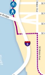
Of particular interest is the closure of the SE Powell overcrossing and a detour near the south end of the Eastbank Esplanade.
Beginning June 15th and continuing for “about a year” TriMet will be working on the demolition of the SE Powell Blvd overpass. The overpass will be closed through the summer of 2013 while a new structure is built in its place.
Below are more details from TriMet about the work they’re doing as well as detour maps for both areas:
Here’s the map for the SE Powell/17th issues:
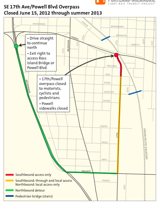
This section of SE Powell is harrowing in both motor vehicle speed and volumes and not having this dedicated bicycling and walking bridge will make it that much harder. TriMet spokeswoman Mary Fetsch says, “Bikes can cross at signalized crossings at SE Milwaukie, 13th or 21st, or use the overcrossing at SE 9th.”
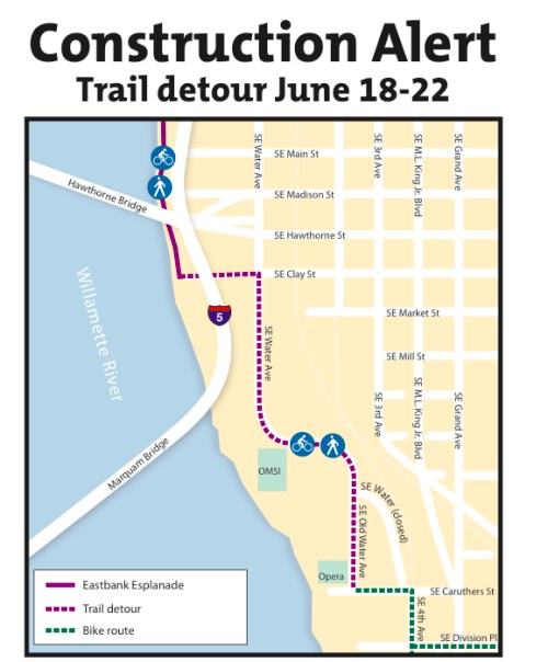
TriMet will also need to close the southern end of the Eastbank Esplanade from June 18th through June 22nd and then another closure in the area will begin on June 25 and last through July or so.
If you are leading a Pedalpalooza ride or otherwise using this popular bike thoroughfare, take note of the map below:
And here’s more from TriMet about these closures:
“Beginning Monday, June 18 through Friday, June 22, utility relocation will close the Willamette Greenway Trail between SE Clay and Caruthers streets. Cyclists and pedestrians will be rerouted onto SE Clay Street and SE Old Water Avenue.
For about three weeks beginning Monday, June 25, cyclists and pedestrians on SE Caruthers Street west of Old Water Avenue will be routed onto the sidewalk and around isolated work areas (phases include closure of the cul-de-sac and flagger-controlled access at the intersection at SE Caruthers and Old Water Avenue). Minor delays expected.”



Thanks for reading.
BikePortland has served this community with independent community journalism since 2005. We rely on subscriptions from readers like you to survive. Your financial support is vital in keeping this valuable resource alive and well.
Please subscribe today to strengthen and expand our work.
The top photo is the over-crossing at 9th, which, thankfully, is not going to close, according to the story.
They _are_ going to close “the octopus” at 17th. But that was a horrible interchange due to the homeless population (dogs, knives, glass, etc). It was an embarrassment as infrastructure, and I’m fairly angry at the police and city crews for allowing such disarray. I knew numerous cyclists who refused to use it. So good riddance, and I hope the replacement is way better.
doh! thanks RyNO Dan. Got rid of that photo. Sorry for any confusion.
I rode that once when I was new in town. It’ll be great to see one of those “never again” problem spots go away.
Haha, beat me to it. Never heard it called “the octopus” that’s pretty hilarious, and yes there are many, many homeless people living down there. But even with as sketchy as that passage is it is a huge time saver for me, you can reach a lot of places quicker by bike than car if you’re heading north coming from 17th.
…because homeless are so dangerous, like ski-bowl owners….
….ha! That’s a good one!… and BTW, I rode the spaces under the tracks every day for 3-4 years. The second summer I lived here someone in an authoritative position had all the wonderful trees removed to thwart the “neighbors” from camping under them. There was a regular named “Randy” who for years was sorta the hall monitor of the area and was able to drive out anyone who happened to not behave like a good Johnson.
(that being the 19th century slang, not the current interpretation)
For many folks that I saw regularly there, it was their home, sad as that is. To be honest, I never encountered anything horribly unsavory all the times I passed through,while keeping alert, of course. IMO, the city and police also did little to help improve it.
WHYYYYYY!!! The agony of trail and bike lane closures during Pedal Palooza [and the summer].
Cannot they do this work in the dark rainy months!!!! Oh the humanity.
It would have been nice if they synchronized this closure with that Oaks Bottom project that will also shutdown the trail to the south.
According to the Bureau of Environmental Services website, the Oaks Bottom habitat enhancement project has been rescheduled (again) — to 2013.
I hope they do something to tame motor vehicles traveling under the tracks through that Powell underpass… they’re usually traveling around 45 mph through there and it’s scary when I’m going 35 mph on the scooter…
I live in Brooklyn, and will be directly impacted by these closures on a near-daily basis. But I’m willing to live with them, knowing what we’ll be getting in return.
same here. I will gladly put up with some temporary detours and traffic for what I hope to be long term gain.
I believe the upcoming 19th St greenway is the work-around
Tri Met blows….
This is the first I’ve heard of the SE Powell overpass demolition. I’m surprised it hasn’t been a big story – this is going to cause a LOT more traffic on 21st, through Seven Corners, and on 12th / Milwaukie. How will this affect the link from Powell to SE 17th? More importantly, how will this area look when it’s done?
I don’t think it’s permanent.
“The reconstructed 17th Avenue crossing of Powell Boulevard will include a wide multi-use path for pedestrians and cyclists that directly connects the Brooklyn neighborhood to the north side of Powell Boulevard. This path will also provide a direct connection from the Rhine Street station to the Clinton Street station via Gideon Street. ”
From here – http://trimet.org/pdfs/pm/stations/Station-Area-Fact-Sheets/PMLR_17th_Ave_Fact_Sheet_August2011.pdf
From the same link Greg posted above, south of Powell 17th Avenue is going to be massively transformed. Pavement for motor vehicles will be narrower than today, but the overall right of way will be widened considerably.
“Bike lanes will be added to SE 17th Avenue to create a safe north-south connection through this area, and sidewalks will be rebuilt with 12 feet in width to create a higher quality pedestrian environment. A new crosswalk will be added on McLoughlin at 17th Avenue.”
“Green corridor: SE 17th Avenue will be transformed from gray to green with an infusion of vegetation that improves water quality and wildlife habitat and provides a signature feature for this corridor. Many new trees and significant stormwater features along the corridor from SE McLoughlin to Powell Boulevard will enhance the streetscape.”
Good visuals at http://trimet.org/pdfs/pm/stations/Station-Area-Plans/Rhine_SAP.pdf
Also, the 11th/12th/Milwaukie/Clinton cluster is going to be completely redesigned too, with a light rail station and much better bike facilities. What’s not clear to me is if bike lanes will extend all the way south to Powell, gateway to my neighborhood and a problematic intersection for bikes.