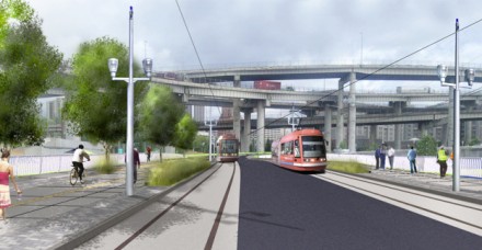
Tomorrow, the Portland Bureau of Transportation will lift the lid on their SW Moody Project that includes what will be downtown’s first-ever cycle track.
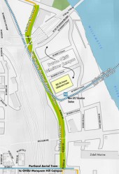
Dotted blue line is
forthcoming Portland-Milwaukie
Light Rail/bridge.
The new cycle track will handle two-way bike traffic on a 16-foot wide path separated from cars, foot traffic, and streetcar tracks (unlike the curbside buffered bike lane on SW Broadway near Portland State University that’s not technically a cycle track). The total cost to construct 0.6 miles of SW Moody from SW River Parkway to SW Gibbs was $66 million and it was funded through a variety of federal, city and state funds (including $23 million from a TIGER stimulus grant).
(Please note: This amount is for the entire project, which includes streetcar/rail tracks, standard vehicle lanes, sidewalks, and more. Based on estimates by PBOT in the Bike Plan for 2030, the cycle track itself probably cost around $600,000.)
Moody’s facelift (literally, they raised the road 14 feet) is part of a larger initiative known as “Portland’s Innovation Quadrant” — a 120-acre section of the South Waterfront area officials say is slated for redevelopment and to, “facilitate new job creation and provide access for people and goods.”
Here’s more from the SW Moody project website:
“As the main access point to the South Waterfront Innovation Quadrant, SW Moody Avenue will be improved to include three traffic lanes, dual streetcar tracks, and pedestrian and bicycle facilities. The new construction will increase roadway capacity and introduce urban development standards such as fiber optic, sewer, stormwater and water infrastructure to support future development. This investment in roadway and streetcar facilities supports the Portland-Milwaukie Light Rail extension, “Complete the Loop” streetcar line extensions, and the Portland to Lake Oswego streetcar line.”
The completion of this project will also be welcome news to folks that have dealt with an annoying bicycle detour during the construction period.
I’m very eager to see how the bicycle traffic lanes have turned out in this project and how they connect with the rest of the system. To get an idea of what it looks like, check out the video simulation (with neat before/after shots) below:
Stay tuned for my “First Ride” report with photos and video. See some very recent construction photos on Portlandize.com.


Thanks for reading.
BikePortland has served this community with independent community journalism since 2005. We rely on subscriptions from readers like you to survive. Your financial support is vital in keeping this valuable resource alive and well.
Please subscribe today to strengthen and expand our work.
I have some aerial view photos of the road between the Ross Island Bridge and CHH on my blog here, at the very bottom (taken yesterday): http://portlandize.com/2011/10/its-almost-here/
About the first photo in your post here – I think the two dark areas on the left of the trees are the two-way cycle track, and the dark area on the right of the trees is the sidewalk (if I understand correctly).
Thanks Dave. I liked the drawing from your site better so I swapped it out. Also added link to your site.
I say! I like you blog, and would like to subscribe to your newsletter! (Actually, what I wanted was an RSS link)
Randall, thanks! You should be able to subscribe just by putting the URL (http://portlandize.com) into an RSS reader, but I’ll see if I can find a widgety thing too, for convenience 🙂
Woot! You’re the best!
Added links at the bottom of the sidebar to RSS and Atom feeds. Cheers 🙂
Key words: “…separated from…foot traffic…”
For any separated “bike path” to be truly viable for transportation purposes, we must move away from MUPs.
I’m glad to see this, but it would have been better if this treatment was done to existing infrastructure that sorely needs it, like the entire length of the Springwater Corridor and the Willamette Greenway in downtown.
good news. I’m pretty tired of maneuvering through pedestrians and cyclists on the sidewalk.
Of course, this is downtown, so bicyclists shouldn’t be on the sidewalk at all.
no Paul, technically Moody is not “downtown” as the law states.
This project site is away from the downtown sidewalk exclusion zone. During construction, cyclists have been “instructed” to use the crummy, dangerous sidewalk, along with those on foot (an arrangement that neither group must be happy about, but it has kept transportation options open). I’ve been taking the adjacent nice, fast southbound lane of Moody. Looking forward to trying the cycle track tomorrow morning – if it’s open when I roll in just before 6 AM.
Interesting thing about that: the “Detour” signs, as well as the flaggers, direct cyclists onto the (dreadful) footpath. However, there is at least one sign that states “Bicycles in Roadway,” implying that we are at least allowed to ride on the road section.
Nevertheless, tomorrow it ends!
yet that’s where the city and construction teams have been telling us to go since January. Its been lovely.
Very good news indeed! Besides the congestion on the sidewalks, that all cyclist were forced onto, the jarring bumps, cracks, pot holes, heavy equipment, and other unforeseen dangers will be in our past. I’m really glad to see this wrapping up.
I hope that people don’t get the idea that $66 million was spend on the cycle track, which is what I originally thought. In careful reading I see that it is only part of what was done but trolls will see that number and scream that bicycles are getting too much.
That might need to be clarified in the article; it certainly threw me off. Jonathan, what’s the cost of the cycletrack alone?
Noted!
South Waterfront can hardly be considered “downtown”… I was bummed to find out this cool new facility is in such an out-of-the-way area rather than actually in downtown proper.
Wow, that’s the most expensive piece of bicycle infrastructure I’ve heard of. 26 miles of the Banks Vernonia Trail was $1.4 million. ~30 miles of the Springwater was just under $15 million as a repave. And now this…barely over half a mile for $66 million, and puts cyclists in one direction in a location motorists aren’t going to expect. I think that almost doubles the lane-mile cost of the Inner Dispersal Loop rebuild project on Tulsa’s downtown freeway circuit.
Paul…the total cost of the project included raising the street 14 feet, building 2 new lightrail tracks, paving, routing and burying new water, sewer, and electric utilities for all of the new south waterfront construction planned over the coming decade. The street was raised to help eliminate conflicts between construction vehicles that will be inundating the area and the general flow of traffic on Moody. It was HARDLY for bike infrastructure alone and the cycle track is a minimal piece of the entire project.
Does that $66 million include the cost of the streetcar or just the cycle track?
If it’s just for the cycle track, man is that a huge waste of money that should have been spread out over more than a 0.6 mile facility.
Pretty sure the $66 million is the entire road construction.
you’re right. Most here are confused and probably havent’ even layed eyes on the project. I’ve ridden by it every day since it started.
and that detour during construction hugely sucked…
That video is totally unrealistic. Come on… a blue sky? Really?
South Waterfront is not “downtown”. Sorry.
OK OK… i wasn’t sure what area to say this is in. At first I had “central City” but that didn’t sound good. I’ve changed the headline. Cheers.
So when will this be connected to the future Naito cycle track?
and how do you get to this thing easily from downtown?
To arrive from downtown (or at least, how I go): ride down Stark to Naito, take a right on Naito. Naito continues up to… ah… I’m not sure what street it is, but it’s right before the underpass. There’s a crosswalk there. Talk the crosswalk across the path to the greenbelt. Follow the greenbelt up to the hotel turnaround, and exit the path there. Take a left at the next street and follow that road up to the next light. Take a left at the light. You’re there!
That sounds a lot more complicated than it actually is.
Ride south on 5th (or 1st or Naito) to Harrison, left on Harrison and just keep trucking all the way there. I guess technically it’s a right turn on Moody when you get to it, but it’s obvious.
Naito’s getting a cycletrack?
That was a joke, but it’s not really funny ;-).
Educating the public that the cycle track is not intended for pedestrians is going to be a HUGE task. Even in places like Amsterdam, where cycle tracks have been around awhile, I personally witnessed mode conflicts with the cycle tracks quite frequently…different colored paving, signs, stencils…nothing seemed to prevent this.
With that said, why is the cycle track next to the street car line? Why isn’t the sidewalk next to the street car line instead? Placing the cycle track next to the street car line is going to create conflicts with pedestrians. Without fail, pedestrians will both walk along and stand in the cycle track, especially near the street car stops. For example, this already happens at the transit centers along the I-205 MUP. Hell, this is even represented in the video above at about at the 2:17 mark!
Cycle tracks will be an interesting lesson about sharing the “road” for us cyclists.
A few years ago it appeared this was going to cost a whoppingly stupid 7 million dollars a block.
Now it seems to have surpassed this…
Reality is we do not need streetcars, nor cycle tracks.
Could have saved a whole lot of money here….
you’re confusing the new I-5 footbridge from Moody into Lair Hill with this project. Yes, they’re adjacent. No, they’re not the same project nor did they have the same budget.
Let’s just stay in the 1970s with are big, gas guzzling cars and complete lack of complete streets while we’re at it! Rabble rabble!
Ahhh, perhaps I am wrong about the respective cycle track and sidewalk placements. It appears that in some of the material regarding the project that the alignments are with the sidewalk closest to the street car line and the cycle path furthest away. I hope so!
Thanks for the update. I live in SWF and cannot wait to see this finished. I think it will really open up SWF area to the rest of downtown.
Unfortunately, many will soon discover that separating pedestrians and cyclists doesnt actually mean anything. Pedestrians will walk anywhere.
It’d be nice if we passed an ordnance to make such a separation legally enforceable. It works out much better in places where this is done. Anybody who’s taken Riverparks East in Tulsa on a cool, sunny fall weekend afternoon knows exactly what I mean.
They just announced that the cycle track and sidewalk portions are open as of 3pm today! Can’t wait to leave work now!
Woo! I am so DONE with that sidewalk!
One thing about the horrible detour, is that it seemed to change at least once per week. Every week a different way to crash!
Cool project, although two-way cycle track, seems to overstate the case a bit. This is hardly along a typical city street, since there are basically no crossings. It’s more like a greenway that happens to be next to a street. The same is true of the Broadway cycle track (or protected bike lane, if you want to get snooty), which also doesn’t deal with turning conflicts. The only cycle track project in Portland that actually addresses this issue is the NE Cully project, which does a good job but is located in a super low-traffic area with few conflicts anyway.
This project seems symptomatic of how conservative Portland is when it comes to actually figuring out how to install cycle tracks on its streets. You guys are getting left in the dust by New York and Chicago, which are blazing ahead with new cycle tracks. Granted, those cities need them more, with their crazier congestion, but there are certainly Portland streets which could use much better cyclist protection. In my opinion, those cities are catching up really quickly, as they are fighting the tough political battles to build their infrastructure. Portland has started to see such conflict, but has largely shied away from many of the difficult projects that truly transform streets.
To put things into perspective, when this project opens, Portland will have 1.5 miles of protected lanes, while NYC will have 23 miles by the end of next year, many cutting through the heart of the CBD. Chicago will have 25 by the end of next year and 100 miles in four years. Obviously these don’t tell the whole story, and Portland is still way way ahead on most other regards and has may exciting projects in the works. That said, infrastructure is really important. The most bike friendly cities in Europe are known for their extensive cycle tracks which allow cyclists to bike comfortably on otherwise busy streets. Unless Portland starts tackling the tough street space reallocation problems, it may someday lose its status as the most bike-friendly city in the US.
Rode it on the way home tonight, and it is wonderful. I did not know it was there, but the nice traffic control people directed me onto it.
Rode it last night and this morning. Very nice ride. Especially, after a year of a kind of sucky commute. Hope that they add more pavement signage, though. Even if it’s not always adhered to, it’s helpful to let riders and walkers how they are expected to share the path.
So looking forward to construction being over. As a pedestrian, I get clipped on the shared sidwalk often enough that I should wear hockey equipment on my daily commute.
*sidewalk
Would be interested if someone could take a GPX track of the new cycleway and it’s approaches both directions and email it to me or submit it to OSM and let me know the track number so I can update OpenStreetMap.
Had an appointment at OHSU this morning and rode the new cycletrack. Nice, except the crossover near the OHSU/Tram streetcar stop makes ZERO sense to me … what, again, is the reasoning behind moving the bike track closer than the pedestrian track to the streetcar platform!? What I saw this morning was lots of pedestrians walking in the bike zone, oblivious to the markings and signage. This was NOT a problem further north, where the cycletrack is on the other side of the ped track as it belongs.
And speaking of oblivious, so are the construction workers taking up residence at several points along the path. They’re still acting as if the thing is closed to the cycling public, and I can guarantee there will be an injury-producing collision involving one of those guys before this thing is finished.
BTW (and echoing some comments above about Portland falling behind other cities), this whole thing is nice, but I just spent a week in #1 cycling city Minneapolis where I grew up. They have lots of two-way cycletracks, and have for many years. Funny how Portland can be in some ways leading and in some ways years behind, all at the same time.