The plan to create a new district surrounding the Oregon Museum of Science and Industry (OMSI) has been in the works for almost 15 years. Tomorrow, proponents of the plan to redesign 34 acres of land in Portland’s central eastside will ask the city’s Design Commission to review their proposal – the most concrete action yet toward breaking ground on the transformative development project.
If all goes according to OMSI’s plans, the project would come with a major new bikeway.
OMSI is a favorite destination for Portland tourists and locals, located near a slew of multimodal transportation options – including MAX light rail, streetcar, bus, bikeways and even a (dormant) submarine. But the museum is located in an industrial part of town with few other nearby attractions.
If it comes to fruition as project boosters want, the OMSI District will include a new waterfront education park and create new access to the Willamette River. It will also be the site of major new residential and mixed-use development, with plans to build up to 1,200 new housing units alongside new restaurants and businesses.
The success of these plans hinges on a major redesign which project proponents say will allow the district to safely accommodate people biking, walking and rolling through the neighborhood while also maintaining car and freight access.
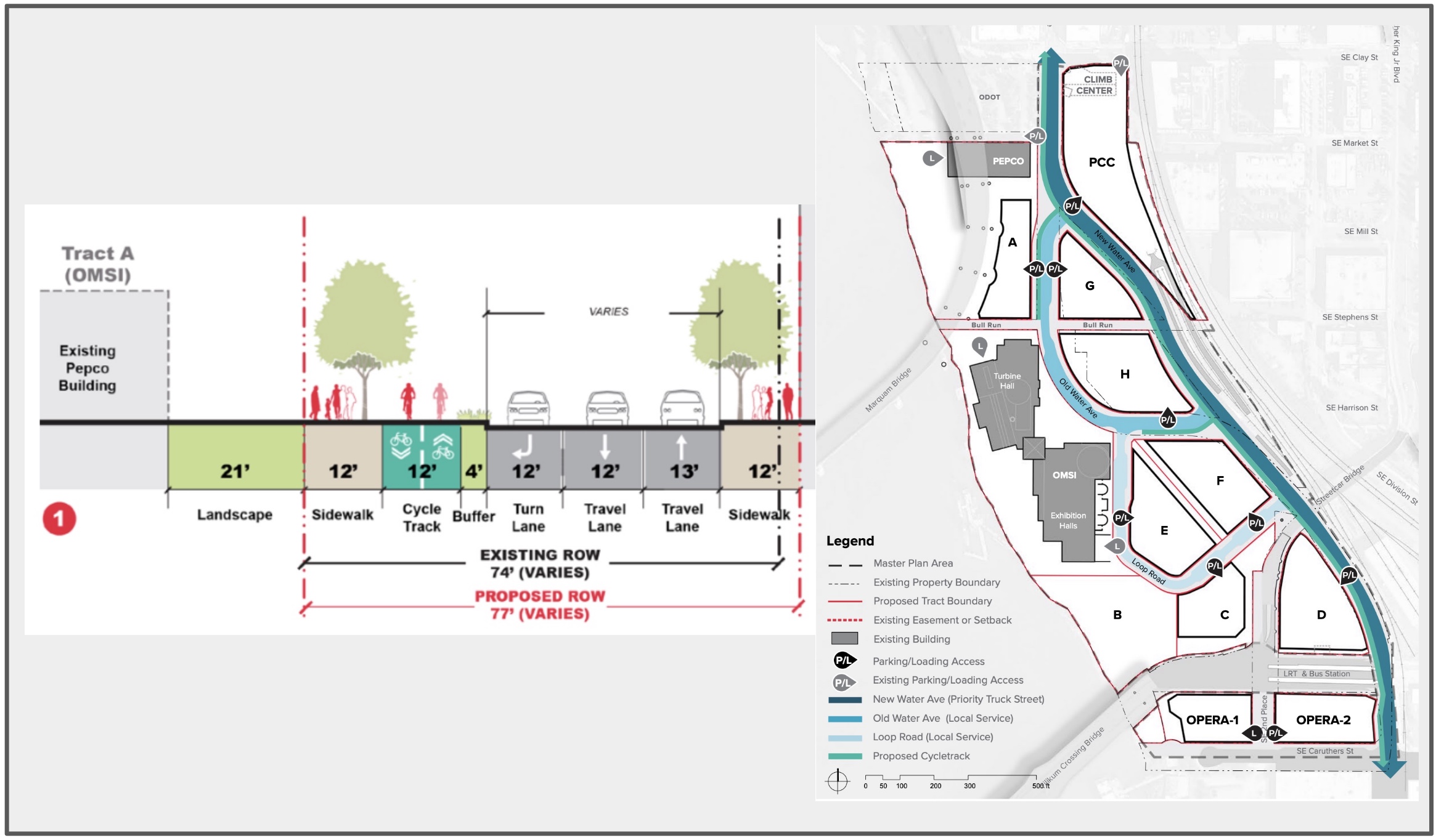
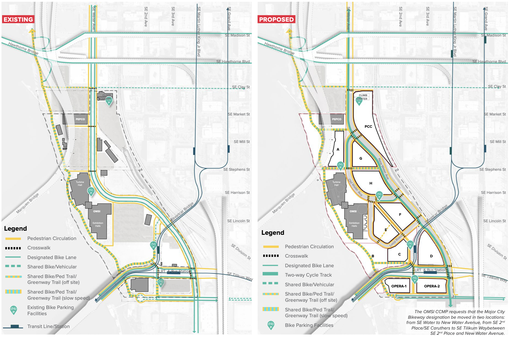
OMSI wants to realign SE Water Avenue, which forms the district’s spine, to the eastern edge of the plan area. This would split the street into two – “New” and “Old” Water Aves – which would serve different purposes for people traveling through the area. There would also be a Loop Road to the south of Old Water Ave and a “central pedestrian spine” running through the district.
“New Water Avenue will allow freight and vehicular traffic heading through to points north or south the center of the plan area on a street with softer curves and fewer access points, while Old Water Avenue is prioritized for pedestrian activity and local service and loading access,” OMSI’s land use review application states. Plans for New Water Ave show 12-feet of dedicated cycling space split between 2 bicycle lanes (six feet each) next to 37-feet split between three, 12-13-foot wide standard travel lanes (which seems excessively wide for a road like this).

New Water Avenue will be “the most direct and convenient route” for through car and truck traffic and include a two-way bikeway along the west side of the street. This new bike route would provide a connection from the central eastside to the Tilikum Crossing Bridge and would also connect the Hawthorne Bridge with the Springwater Corridor path.
Old Water Ave will also have the two-way, 12-foot bikeway — except for one block in front of the main plaza where the plans show the bikeway vanishes and is replaced with a bus lane.
But as we’ve pointed out before, the existence of this New Water Ave wouldn’t be a deterrent to people biking on the Eastside Esplanade or within the OMSI district. Old Water Ave will integrate a two-way cycle track as well, and the plan is to include 12-foot-wide sidewalks with 8-foot through pedestrian zones, street trees, and landscaping.
Advocates for the Green Loop around Portland’s central city foresee the OMSI district playing a key role in the future active transportation circle. With two carfree bridges on either side of the district – the Tilikum Crossing and the new Blumenauer Bridge – its in a good position to offer active transportation connections to the rest of the city.
Because this project is so large, it won’t be able to receive approval without significant conversation between the involved city bureaus and organizations. There is already some design pushback beginning to emerge: a staff report released earlier this month includes a skeptical memo from PBOT’s engineering department, which states “while the layout and general geometry of the existing and new public streets acceptable, the details including lane widths, stacking lanes depth, location and design of protected bike lanes, and the number and location of new traffic signals is still under review.” They note a particular concern with how cyclists will enter the new district just south and north of the site. All of this will be up for conversation at Thursday’s hearing.
The Design Commission plans to review the OMSI district plan from 4-6 pm at tomorrow’s hearing. You can register to testify here, and stay tuned for updates as the plan moves forward.


Thanks for reading.
BikePortland has served this community with independent community journalism since 2005. We rely on subscriptions from readers like you to survive. Your financial support is vital in keeping this valuable resource alive and well.
Please subscribe today to strengthen and expand our work.
If all goes according to plan, this and the Albina Vision, along with the planned ODOT blocks up north, will dramatically transform Portland’s Eastside downtown in a equitable manner.
Really? Reality check time. How much of the new housing they build in the CEID-OMSI area do you think is going to be low income vs. market rate? Do you think losing the Flint Ave. I-5 crossing is a desirable tradeoff for the ODOT project? IMO, my answers are very little and no. But thanks for playing! 😉
Okay look, obviously every development/infrastructure project has its strengths and weaknesses. To answer your question on the amount of affordable housing it is 20% of the 1,200 total units. I would agree in saying that there should be much more affordable housing (at least half of the provided units) but this is better than nothing at all.
At least 20% of housing units in a new building are required to be set for low-income. This comes at the expense of increasing the cost of the remaining 80% of units.
Developers can pay a fee to get out of the inclusionary zoning requirements. Most do.
I thought the Hybrid 3 option agreed upon preserved the Flint Ave I-5 crossing. Am I wrong?
Shoot, I’d be happy with a better connection from Water to the Hawthorne bridge that didn’t go down on the Eastside Esplanade.
Most of this is good, but note that the plan shows that they are also requesting to remove the Major City Bikeway designation from the block of SE 2nd Place, south of the train station, and from the two blocks of SE Caruthers between the Opera and Water Ave.
Instead bikes would be routed east along both sides of the train station and then south on Water Ave.
I think this would be a disadvantage.
Yep. Looks like everyone would be forced through the cattle chute by the Orange Line station.
That doesn’t mean you can’t ride your bike on it anyway.
I’ve never understood why people don’t ride straight up Water from the Springwater anyway – way faster than going down to the esplanade then dealing with the crowds.
Every once in a while at 4pm (ish) I have a car go by me. Most of the time the traffic is so light I don’t see one before turning into the far northern part of the OMSI parking lot to get to the esplanade (for as short a time as possible – /shudder) and up onto the bridge.
Yesterday I saw *2* cars – they were stopped in front of me for a very large group crossing the crosswalk into OMSI (lots O’ kids).
I’m also concerned about having a 2-way bike path on only 1 side of Water street. Unless this is continued all the way north and south for the whole length of Water, it will mean bikes will have to switch sides of the street once or even 2 times in a few blocks. This will also increase the risk of collisions with vehicles crossing Water Avenue since some bikes will be going the “wrong way” on that side of the street.
A better plan would have grade-separated bike paths on both sides of the street, rather than only one side. This would allow easy merging into the bikes lanes to the north and south.
I agree, two way bike facilities are only useful when/where there are no cross streets.
The Central City in Motion plan includes a 2-way bike path all the way along SE Water, and up SE Stark as far as SE 3rd.
I am pretty confident that the 2-way MUP design is to appease the freight/driving interests in the CEID. This is an effort to get bikes out of the way of people driving at the expense of biking comfort, dfety and utility- typical PBOT these days.
While that makes sense with the current configuration, I think the current proposal for a 2 way path makes the most sense going forward. CCIM has a two way path on Water up to Stark on the north end and the Springwater is just two blocks south which PBOT could and should do a really easy restripe of 4th to connect them. Basically extending the Springwater into OMSI and the Central Eastside.
I agree – 2 way cycle paths increase the risk of left hooks.
IE – when the cyclist is going opposite the direction of the closest lane, vehicles approaching from behind and turning left are a big danger (witness the collision on the 17th ave path a while back).
That driver is turning across a lane of traffic before going through the path and their focus is usually on oncoming traffic, not the path.
Additionally it’s hard for a cyclist to pick them up because they are 15 feet to the right as well as behind. Even when riding something with a righthand mirror I don’t see them over there.
That’s how come I don’t ride the southern part of the 17th ave path with it’s driveways. I ride the bike lane instead up to Millport before hoping on the path.
I agree- 2-way paths do not work well as part of a tranportaion grid. They to too difficult to connect to and from. dedicated lanes with some separation are much more useful
When the first two-way track appeared in Portland, I was surprised but willing to give it a go. Now, there’s not one I’ve tried (and I use a few regularly) that I like. I find them awkward and ill-designed for multiple bikes – transitions at intersections is where I find them especially bothersome (especially when I’m riding a cargo bike or when another bike is approaching from the other direction).
Come on PBOT, let’s have a one-way cycle track in each direction, that would be truly worthy of this highly congested area. Remember, this area is a gateway to the Springwater Corridor and bike use is high most times of the day.
Wouldn’t building a new Water Ave trigger the bicycle bill requirements for bike facilities, regardless of the presence of the Esplanade? If so there shouldn’t even be any debate about it (but remember last time, the BTA had to sue the city to get bike facilities on the new roads in the Rose Quarter).
I’m not a huge fan of the 2-way bicycle paths… can anyone make a case for why they’re good here?
The CCIM plan has a two way path on Water up to Stark on the north end and the Springwater is just two blocks south of the OMSI district which PBOT do a really easy restripe of 4th to connect them together, extending the two way Springwater path into OMSI and the Central Eastside.
dedicated lanes for bikes with separation would be better
With a 4′ buffer between the bikes and cars, why not?
Or would you rather have the bikes lanes each side with only a 2′ buffer?
Bike lanes on each side is preferable and safer in my opinion. I don’t think 2 extra feet of buffer increases safety, but forcing more people to cross 2 lanes of car traffic more frequently is less safe.
Riding along the river is lovely, but it will be great to have this new high-speed bicycle route that avoids pedestrian conflicts! Regarding the OMSI district in general, I’m cautiously optimistic. It will be nice to make the OMSI area more of a destination, anchored by the museum and lined with science-themed shops and cafes. There’s also a lot of opportunity to improve the pedestrian experience between the Orange Line stop and the museum.
It is crazy to me that there is not a plan to add bike/ped accommodations to the streetcar bridge to connect to Grans/MLK! That would really connect this new district tothe Central Eaastside and provide a a great option for people walking/biking to avoid train delays.
The bridge is too steep to meet ADA, so no sidewalks for you. But yes, it would be great, as would be adding bike facilities to the viaduct going from OHSU up the hill (try riding down it someday, and you’ll see what an awesome bike connection it would make).
So many lost opportunities.
By the time this project is completed, let’s say 2030+, the city expected bike traffic to increase by a lot. So this design is already outdated, adequate perhaps for today’s traffic, but definitely doesn’t take into account future use patterns. I would take off at least one car lane and replace it with another bike lane. Three car lanes make for a noisy polluted road, hardly appropriate for the proposed use of this area.
It would seem most of our societal issues stem from our inability to think long term when making critical decisions.
That was then, this is now. Hardesty utterly dismissed that plan at her infamous Bicycle Advisory Committee presentation, and I don’t know any serious people who think we’ll be anything near achieving those goals. I’ll be surprised if we are even close to our past peak bike commute rate in 2030.
So while I want the facility to be bigger, the expectation that bike traffic will increase by “a lot” seems largely fanciful, and runs counter to the about a decade of mode share decline.