“It seems once again that the burden of safe behavior is being placed entirely on pedestrians and bicyclists. Nothing is being asked of drivers.”
-Tiel Jackson, Portland Pedestrian Advisory Committee
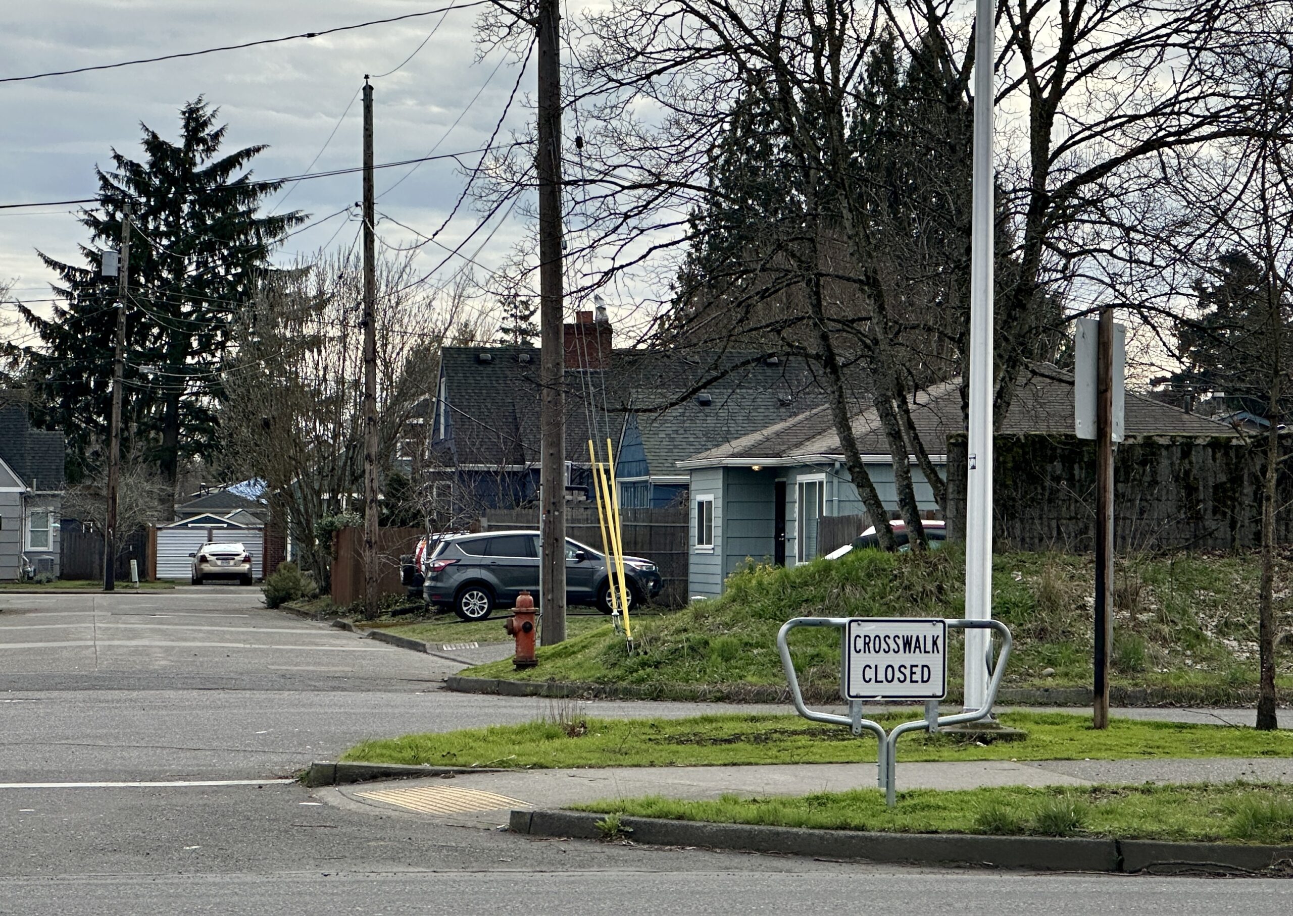
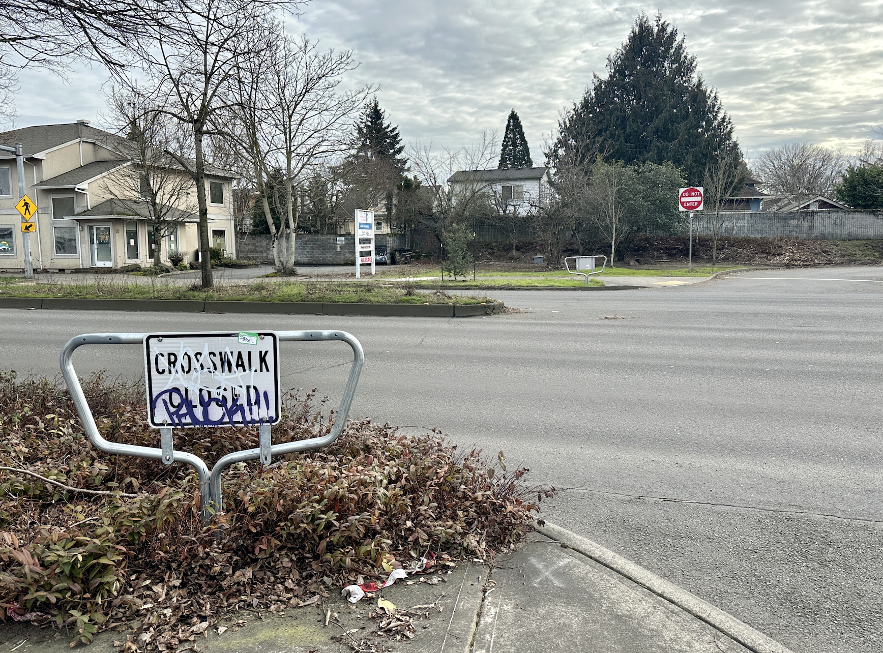
When the Oregon Department of Transportation quietly released the news that they planned to shut down 181 crosswalks in the Portland metro area two weeks ago, people had a lot of questions — like which exact crosswalk legs were on the chopping block and why ODOT was making this decision. Transportation advocates were also confused and frustrated about the agency’s lack of transparency and public involvement in the process.
“There was no public process, no public notification, no public input of any kind. All of these crosswalk closures just started popping up,” said Tiel Jackson, co-chair of the Portland Pedestrian Advisory Committee (PAC) at a meeting earlier this week. “And that makes it really difficult to build a climate of trust with ODOT, especially with these other major projects that we have going forward.”
These “major projects” include the I-5 Rose Quarter expansion and subsequent plan to cap the freeway and reconnect north Portland’s Albina neighborhood, which has faced scrutiny and backlash for a long time. Given the particularly dangerous conditions for people biking and walking on ODOT-owned streets in Portland, transportation advocates are asking the agency to refocus their financial priorities away from increasing freeway capacity and toward making their streets safer.
To ODOT, these crosswalk closures are essentially a formality — the agency says the crosswalks they’re blocking off have been closed in essence long before now — and keeping them open would pose safety problems.
“The whole point of this is a safety question to make sure we’re directing pedestrians to the safety possible crossing at each state road. We don’t want people crossing at unsafe places across the highway,” ODOT Public Information Officer Don Hamilton said to BikePortland. “We want to make sure that they get to the safest possible crossing specifically on Powell Blvd, where we’ve had some problems in the past.”
Active transportation advocates say this strategy is misguided and puts the onus of safety on vulnerable road users instead of traffic engineers and planners who could make these streets safer with more ambitious — and less car-centric — redesigns. But ODOT is going ahead with their plan — many of the crosswalks are already closed. And without any pushback against ODOT from other local transportation agencies, it’s unclear what the path forward is for fighting these closures.

Reasons for closure
The initial information ODOT provided about the crosswalk closures was sparse in details, but the agency has now released a full list of crosswalk closures in Portland with specifics about which leg of the crossing will be closed and the criteria for the decision.
Some of the criteria ODOT outlines for closing these crosswalks include: median obstructions in the middle of the street with no cut-throughs; lack of pedestrian facilities or shoulders; inadequate sight distance for people driving to see people walking across the street and crossings aligned into driveways.
Portland Bureau of Transportation (PBOT) staff were caught off-guard by the announcement, as ODOT staff didn’t inform them about it ahead of time. But they ultimately came to the consensus that these criteria were acceptable and well-informed.
At a Pedestrian Advisory Committee (PAC) meeting this past Tuesday, PBOT Interim Pedestrian Coordinator Gena Gastaldi gave an update regarding PBOT’s temperature on the crosswalk closures.
“We didn’t know this was coming — we were not briefed on it beforehand, either. It came as just as much of a surprise to us as it did to everyone,” Gastaldi said. “What my colleagues and I found looking at the list of crossing closures is that a lot of them were just formalizing crossings that were already closed…I think there was some room for improvement with the unveiling or messaging around [ODOT’s decision], but from what we’ve all discussed at PBOT, these are all locations we would probably be closing as well.”
This may not be sufficient reasoning to people who have also criticized PBOT for closing crosswalks in the past.
Another reason ODOT cites for closing a crosswalk is if there’s a crossing nearby they deem safer that they want people to use instead.
This is the case for several crosswalk closures on Powell Blvd, including at 45th, 57th and 70th Aves. ODOT also cites this as a reason for closing the westerly crosswalk on Powell and 61st, an intersection due for an enhanced crosswalk on its eastern side through a TriMet plan. (ODOT has already shut down the western crosswalk at this intersection — but TriMet has yet to deliver on its planned crossing on the other side of the street. TriMet planners didn’t know about ODOT’s plan ahead of time.)
The ADA lawsuit
When ODOT announced their decision to close the crosswalks, they said it was a way to comply with Americans with Disabilities Act (ADA) curb ramp standards at crosswalks that are “unsafe and inaccessible.” But the decision raised eyebrows among people involved in the lawsuit, who thought it may have been ODOT’s attempt to get out of their legal responsibilities.
In 2016, a group of Oregonians sued ODOT, alleging the state hadn’t build ADA-compliant curb ramps while constructing and maintaining state highways. They later settled out of court. Per the settlement agreement, ODOT completed a survey of curb ramps on state highways and found that 97% of the 26,000 ramps they inspected didn’t meet ADA standards. Ten Oregon counties didn’t have a single compliant ramp.
According to the terms of the settlement, ODOT needed to remediate 7,770 curb ramps statewide by December 31, 2022 (30% of the total ramps that need work statewide). Per a 2021 audit report of the ADA Settlement Agreement (pdf), the agency had completed 3,744, leaving about 4000 more to be done in 2022.
Tom Stenson, a senior attorney with Disability Rights Oregon who has been involved in the lawsuit, believes part of why ODOT decided to close the 181 crosswalks is because they weren’t meeting the timeline for fixing the ramps, and he is skeptical about the other reasons the agency cited for the crosswalk closure plan.
“I think what’s troubling is under their own rules, they can’t just close a whole swath of crossings. There are actually pretty specific rules that they have to follow,” Stenson told BikePortland. “And it seems unlikely that they’ve been able to follow the very exacting requirements for closing in this context for hundreds of crosswalks in one go.”
Closing crosswalks is a legally acceptable way to comply with ADA requirements, and ODOT has done this to fulfill ADA standards at a variety of crossings across the state. But Stenson said he doesn’t think this is a good faith reading of the settlement agreement.
At the PAC meeting on Tuesday, Portland ADA Coordinator Lisa Strader — who was ODOT’s ADA Coordinator in the aftermath of the lawsuit settlement — offered a different perspective. She said the locations ODOT chose to close are genuinely unsafe and can’t be remedied, and many of them have already been closed for a long time. The formalizing of the closures is to meet the ADA settlement requirements, but not due to nefarious reasons.
“One of the ways that they can make a corner or the curb ramp compliant is by closing a crossing…ODOT recognized that they already had closers in place, but they didn’t have all the documentation because the process changed over time,” Strader said. “It’s mostly a clean-up process to be sure that they’ve formally done everything they need to do under their under their settlement agreement related to where they close a crosswalk and effectively then close the curb ramp.”
BikePortland reached out to ODOT’s communications team for a comment on the relationship between the settlement and the lawsuit, but haven’t heard back.
What advocates are thinking
A press statement issued last week from advocacy non-profit Oregon Walks states the organization’s intent to keep fighting these crosswalk closures.
“For pedestrians in Oregon, crossing the street is more dangerous than it has ever been. In just the month of January, three pedestrians in Portland were killed on streets that the public has begged ODOT and PBOT to make safer for years,” the statement reads. “Be assured that we are reviewing these closures and where appropriate will advocate for not only the reversal of the closures, but an investment in their improvement.”
Per Oregon law, a crosswalk exists at every public road intersection, whether or not it’s marked. Many of the crosswalks ODOT is closing are genuinely unsafe for a variety of reasons. But advocates still want to know why those problems couldn’t have been remediated instead of just shutting the crossings down entirely.
“It seems once again that the burden of safe behavior is being placed entirely on pedestrians and bicyclists. Nothing is being asked of drivers,” said PAC co-chair Tiel Jackson at Tuesday’s meeting. “What problem is this really trying to solve and it’s the best way to go about solving it? In what world does giving us fewer walking options actually make us safer?”
PAC member Mary Lee Turner, an accessibility advocate who is blind and uses a white cane to help her get around the city on foot, pointed out another safety concern about the crosswalk closures.
“What if I’m out there and I go across the street and the crosswalk is closed? How am I going to know it as a person traveling who’s blind?” Turner asked. “Now it’s getting even scarier [to walk in Portland].”
Jackson said the way ODOT went about this process is only contributing to the feelings of distrust many advocates have about the state transportation agency. Above everything else about the specific qualms with the crosswalk closures, this is the big takeaway many advocates appear to be getting from this situation.
“I started off very challenged with trusting ODOT,” Jackson said. “And I continue to be very challenged.”