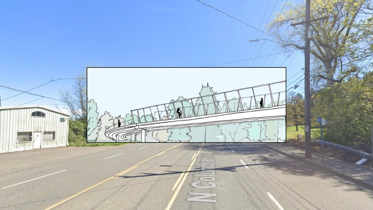
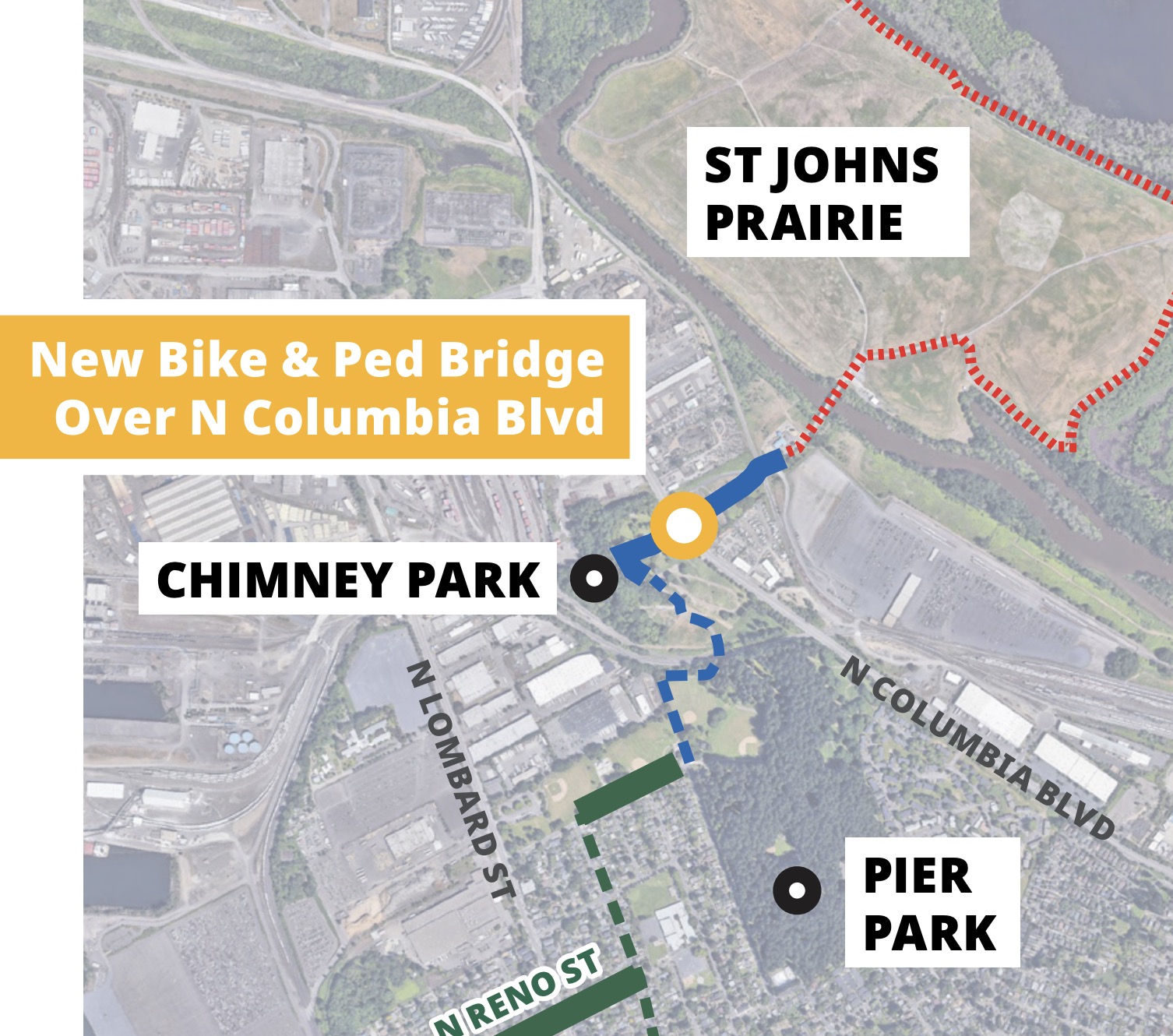
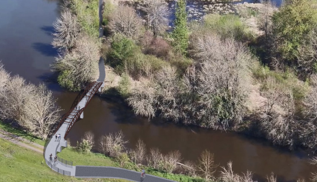
A project that will build a carfree bridge over Columbia Boulevard in north Portland is officially back on track. The project is a vital link in the North Portland Greenway Trail and the 40-Mile Loop and it will connect St. Johns neighborhoods with existing paths in and around Kelley Point Park.
Portland Parks and Recreation says they’ve restarted the design and public outreach process after previous setbacks resulted in a pause on the project. The initial process to design the bridge kicked off in 2019, but a budget snafu emerged in 2023 which forced Parks to put the project on the shelf. That delay led to widespread disappointment and frustration.
Last year I reported that Parks remained committed to the project. Now we know they’ve kept their promise.
Parks, working with Metro and the Oregon Department of Transportation, has lined up additional funding to see the project through. Estimated to cost $11-$15 million, Parks is using a $2.7 million grant from Metro to continue designing the project and will host an open house on July 16th. According to a spokesperson, Parks is also in the final stages of accepting an additional, $6 million grant from ODOT’s Oregon Community Paths program.
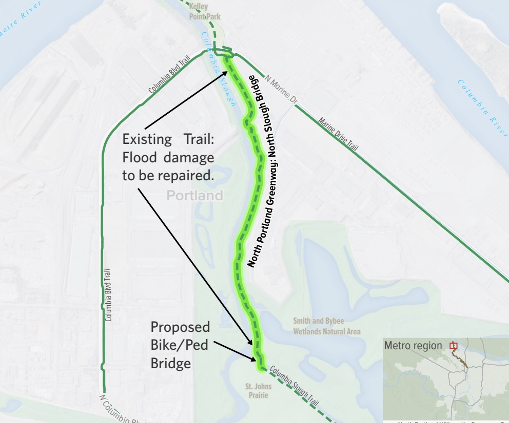
The bridge will go up and over Columbia Blvd (an ODOT-owned freight corridor) between Chimney Park and what used to be the St. Johns Landfill. Thanks to Metro, the landfill has been restored into prairie land. Northeast of Chimney Park, the path will run along the Columbia Slough toward Kelley Point Park. (A related project to complete the final, 1.3-mile gap between Chimney Park and Kelley Point is already in the works. The North Slough Bridge project (see below) is estimated to cost $14 million and would build another bridge over the Columbia Slough and renovate an existing path alignment that’s been effectively closed for years due to flood damage.)
According to Parks, the Bridge Over Columbia project is in 60% design phase and a public survey seeking feedback on the design will be released on July 17th.
If you’d like to learn more, join a bike ride from downtown Portland to the July 16th open house. Parks staff will share updated design drawings and the project team will be available for questions.
Final design is scheduled for completion in late 2026, with an anticipated two-season construction schedule (due to steel procurement) pushing the completion date to 2028.
Learn more at the official project website.


Thanks for reading.
BikePortland has served this community with independent community journalism since 2005. We rely on subscriptions from readers like you to survive. Your financial support is vital in keeping this valuable resource alive and well.
Please subscribe today to strengthen and expand our work.
Slight correction: I’m like 95% sure that Columbia is owned by PBOT
Correct
According to Portland Maps it’s owned and maintained by PBOT. https://pdx.maps.arcgis.com/apps/webappviewer/index.html?id=322fb44af46e48de9345dd491f5dc437
I am 100% sure that Columbia Blvd is owned by PBOT. It has never been a state highway. People get this wrong all the time. Highway 30 Bypass is St Johns Bridge, then N Ivanhoe St east of the bridge, then a wee bit of N Richmond Ave, then Lombard St east of Richmond Ave all the way out to NE Sandy Blvd. At no point is Columbia Blvd a state highway or under ODOT control.
I am very excited about this and very proud the PP&R and Metro lived up to their promises. Metro was supposed to have trail around the east side of the landfill open a couple of years ago, any idea what happened to that? It has mostly removed from their website.
Just a minor quibble about this line
The landfill is certainly more than memory! It is fully intact and has to be actively monitored to avoid contaminating the slough and river. The landfill produces methane gas that Metro captures and repurposes. The landfill is capped with a waterproof liner and a couple of feet of soil to avoid water getting into it and to support a native prairie. Metro has done a great job of establishing a native prairie, but the necessity of a cap is a permanent limitation to uses on top of the landfill.
Exactly. It’s basically the Fire Swamp, so the public still isn’t allowed to even gaze in it’s general direction. These environmental atrocities aren’t a memory, they’re our legacy. 1) The flame spurts? No problem, there is a popping preceding each and Metro has a lattice of methane gas collection flares to take care of that. 2) Industrial contamination run-off? That will never go away, but at least we are all mostly upstream so in the future we can avoid that too (except for the RV camp). 3) Horned larks? I don’t think they exist.
Y’all are describing every modern landfill. Geosynthetic linings and gas capture are *good* things.
The landfills aren’t environmental atrocities. They are necessary infrastructure that preserves the environment.
I used to monitor the landfill gas and maintain the gas extraction system at the Home Depot in Oregon City, which was built on an old illicit landfill.
Under the store was properly capped. But just off site, you didn’t have drill down more than 6 feet to find landfill gas bubbling through groundwater.
This is no “modern” landfill. It’s a plastic cover. It needs to be monitored in perpetuity with no public access — right near the confluence of our two ancient rivers and abutting the beautiful Smith and Bybee wetland. It only plays second fiddle in the news because of the myriad surrounding Superfund sites and the occasional greenwashing about potential access. Using quotes or asterisks around the word good is quite telling, or perhaps it’s the six fingers?
Yeah. Modern landfills are lined at the bottom and top. Some circulate bacteria-laden water throughout the waste to help it breakdown faster, which generates more gas. Leachate management from within the waste is a challenge too. The QA/QC process of welding the liners together is pretty cool too.
Restricting access is pretty common if only because of all the technology involved, but also to manage air quality around the flares.
I agree, and thanks for the additional information. I raised the point to add some context for the article’s original claim that the landfill is effectively gone. It t very much still in place and will be managed for the foreseeable future. That said, it looks attractive and is safe and pleasant to be near. The landfill itself may be able to support some very limited access and activities, but the bike bike access will be limited to the road around the perimeter.
How about ROUSs though. My understanding is they don’t exist.
Great news! Can’t wait to ride over this. Combined with all the improvements on Willamette and the nice lanes on Smith and Fessenden, the Peninsula Crossing Trail, etc., riding through St. Johns is getting better and better.
I had a time delay of about half a minute between seeing “River”, then re-reading the title and seeing that it says, quite clearly, “Blvd.” Anyone else? 😎
So great to see really meaningful projects like this one in other parts of town.
Here in SW, we only get really dumb projects like the Red Electric bridge, which goes nowhere.
Huh? As far as I can tell, this new ridge literally goes nowhere. On the other side is some heavy industrial and then a prairie with no trails that doesn’t connect with the trail near Wapato without a another bridge being built.
I’m assuming this project was ‘attainable’ but working on connecting Swan Island to the path at Steel Bridge would have been way more valuable.
Oh wait: the way JM described the new bridge, I thought it would be useful (I don’t live in that part of town, obvs). Thanks for the clarification.
There is currently a (delux) bridge to nowhere across the train tracks between the park (Chimney) and Columbia. One can take Columbia west from this project (for a couple of blocks) ot get on the ‘normal’ Lombard route between Cathedral and Kelly Point Parks. I frequently encounter folks on bikes commuting home at Columbia and Portsmouth (a very unpleasant crossing). I presume some of them would get some utility from this crossing. I assume PBOT will get it together to connect to Kelly Point, but that may be giving them too much credit.
It can take a while to piece together a trail that is projected to run several miles through existing, developed neighborhoods. That bridge won’t be isolated forever: https://www.portland.gov/parks/construction/red-electric-trail
last time I tried to ride through here (a couple years ago) I found the bridge over the slew to the former landfill had a fence and barbed wire over it. That is the real obstacle to cycling, not this bridge.
Maybe PBOT could work on getting that fence removed to allow public access
https://www.google.com/maps/@45.6099238,-122.7546894,93a,35y,15.55h,36.53t/data=!3m1!1e3?entry=ttu&g_ep=EgoyMDI1MDcwNi4wIKXMDSoASAFQAw%3D%3D
The fence belongs to Metro not PBOT. Metro has already designed a path and overlook that starts at this gate and wraps around the east side of the former landfill. I agree they should open it today! There is already a nice gravel road around the base of landfill that would allow valuable recreation (biking, walking) and birdwatching on the adjacent prairie and lakes.
I’m confused about this. I took a screenshot from http://portlandbikemap.com/ and drew a red line where it looks like the bridge will be and it looks like it’s disconnected from other bike infrastructure.
https://ibb.co/xSwXkrq6
Hi Adam,
Yes I should have added more context here. There are other projects that will be triggered by this, including another bridge over the Columbia Slough that will connect to an existing piece of paved path that isn’t shown on maps because it’s a dead end and is effectively closed for years due to flood damage.
Metro and Parks are already working on this final, 1.3-mile gap and you can learn more about it here.
Ah, very cool! Thanks for clarifying.
There’s a bridge connecting Pier Park to Chimney Park over the railroad line. This will connect to that.
I really hope a proper job is done to connect a path through the old landfill to the current, dilapidated path that runs south from Kelly point. Unfortunately it’s currently very easy to access this path from marine drive with a car.. the last time I was out here – about a year ago – there were more drivers on the path than recreational users.
Restoring the current path, connecting it to the dump, and making it all motor vehicle inaccessible are what will make this project successful.
Final Design is scheduled for completion in late 2026, with an anticipated 2-season construction schedule, due to steel procurement. Will you please update to Bridge and Trail Opening 2028? Thanks